
リスク対応策 2022.09.15
RM75 史上最大級の地震の痕跡発見(和歌山「橋杭岩」)
目次
For those who prefer to read this column in English, the Japanese text is followed by a British English translation, so please scroll down to the bottom of the Japanese text.
本コラムでは、「キャプティブの有効活用によって企業のリスクマネジメント態勢を強靭化すること」を目的として、その効用を大きく高めるリスクである「地震リスク」を中心にキャプティブの活用法を記してきた。
本年、2022年6月30日投稿した「RM74『地名に潜むリスク』へ備えるキャプティブ 9(「紀伊大納言」和歌山)に「和歌山市の南の方に青く湾曲した一帯が見える、和歌浦に面した『海南市』である。その場所に次の『自然災害伝承碑(地震・津波)』がある。」と、その概要を以下のように記した。
概要
碑名: 南海道地震津波浸水水位
災害名: 昭和南海地震
(1946年12月21日)
災害種別 : 地震・津波
建立年: 1991
所在地: 和歌山県海南市名高
伝承内容 :
昭和21年(1946)12月21日に発生した昭和南海地震により襲来した津波の到達と水位を示している。
海南地区では地震後40分で第1波が到達し、その後第2波が最大となり、津波の高さは湾奥で3.21mにのぼった。
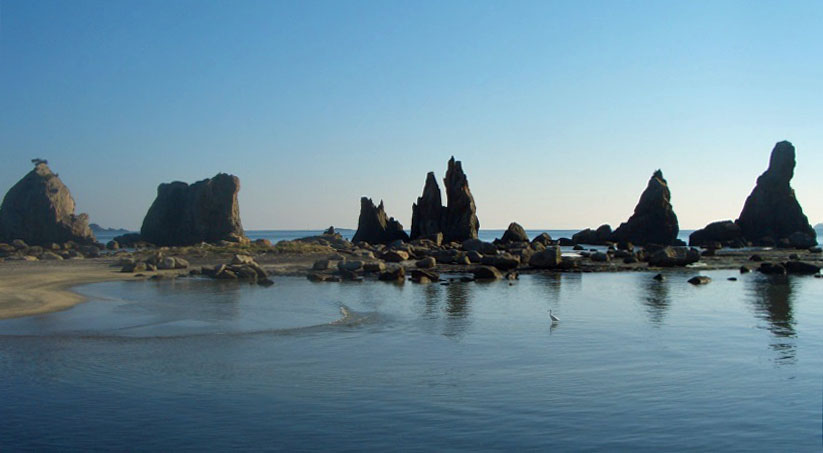
「橋杭岩」
(出典:「南紀熊野ジオパーク推進協議会」ホームページより)
1.和歌山で新たな津波の痕跡を発見
日本最大級の地震と推定されている、1707年に起きた「宝永地震」は、「東海、東南海、南海」の三連動地震が発生したものと考えられている。しかし、文献上の記録が無いため、あくまでも「推測」の域を出なかった。近年、過去に津波を経験した土地の歴史を示す「津波堆積物」の調査がおこなわれ、その推定エネルギーは、「マグニチュード:M8・6)を上回る地震」と解明された。
今週、2022年9月12日、国立研究開発法人 産業技術総合研究所(「産総研」)を中心にした研究チームは、和歌山県串本町にある名勝「橋杭岩」(はしぐいいわ)周辺の地質の痕跡を調査、「南海トラフ沿いで史上最大とも呼ばれる、この1707年に発生した宝永地震の津波よりも大きな津波がこの地域に来襲したことを解明した」と同研究所ホームページに掲載、各メディアが一斉に報道した。
この「橋杭岩」とは、海岸沿いに大小40余りの岩柱が立ち並ぶ名勝地であり、これが崩れてできたとみられる、推定・最大85トン規模の巨岩が陸側に約100メートルにわたって散乱している。産総研を中心とした研究チームは、巨岩は津波などで陸側に流されたものと推定、その数1300個に及ぶ岩の位置、大きさを計測して、津波のシミュレーションをおこなった。
産総研のホームページには、その研究成果の概要が次のように掲載されている。
「海岸に一直線に並んだ巨岩列で知られる橋杭岩はマグマの貫入によってできた岩石です。橋杭岩の周辺には、多数の巨礫が散らばっており巨礫も同じマグマ由来の岩石からなるので、橋杭岩から分離して周囲に移動したものと考えられます。その移動の原因について過去に大きな津波や高潮などで巨礫が橋杭岩から運ばれたためと推定しました。そこで、これらの巨礫の位置や大きさを測定し、どのくらいの規模の津波によって巨礫が動くか計算しました。
この結果、南海トラフ沿いで歴史上最大とされる1707年宝永地震の津波の規模でも動かない巨礫が存在することがわかりました。これは、1707年津波を超える大きな津波がかつてこの地を来襲し、巨礫を動かしたことを意味しています。全ての巨礫が動くためには、1707年地震に加えて沖合のプレート境界の分岐断層が大きくすべることや、あるいは1707年地震の断層面上が2倍を超えて大きくすべることなどが考えられます。なお、研究の詳細は2022年9月6日にTectonophysics誌に掲載されました。」
2.南海トラフ地震
気象庁のホームページには、「南海トラフ地震」について次の通り記されている。
南海トラフ地震は、駿河湾から日向灘沖にかけてのプレート境界を震源域として概ね100~150年間隔で繰り返し発生してきた大規模地震です。前回の南海トラフ地震(昭和東南海地震(1944年)及び昭和南海地震(1946年))が発生してから70年以上が経過した現在では、次の南海トラフ地震発生の切迫性が高まってきています
「南海トラフ地震」は、記録の乏しかった中世以前では200年、その後は100~150年の間隔で発生してきた。ごく最近では、1944(昭和19)年12月7日に発生、東海地方に大きな被害をもたらした「昭和東南海地震」がある。しかし、戦時中のため報道されることはなかった。
以前から「震度7相当の地域がある」と推定はされていたが、2019年末、この地震による各地の震度分布を名古屋大のチームが再評価した結果、「愛知県の西尾市、静岡県の菊川市と袋井市の3カ所が『震度7』と判明、揺れが大きかった地域は(今後の大地震への)注意が必要だ」と報道された。
この南海トラフ地震の想定震源域は、3つに分かれている。静岡地方を想定震源域とする地震が「東海地震」であり、愛知、三重、和歌山を想定する地震が「東南海地震」、その以西宮崎沖まで伸びる想定震源域を持つ地震が「南海地震」である。時間差があっても、前述のとおり、これら3つの震源域が連動する可能性が高いと言われており、「東日本大震災を遙かに凌ぐ、超巨大震災になる」と予測されている。
その被害予想に関して、以前、内閣府は南海トラフ巨大地震の被害想定について、揺れが最大になる場合には、震度6強以上のエリアが太平洋岸に広範に広がり、「死者は32万人を超え、経済被害も220兆円を超える」との想定をしていた。しかし、2019年5月、このうち死者の想定数を23万人強に引き下げた、理由としては「東日本大震災の後に住民の津波避難の意識が向上したことが影響した」と述べていたが、「今後の調査結果によっては再び想定が増えることもある」とも付言している。
従来の地震の被害想定では、「揺れによる物的損害」が最も重視されていたが、東日本大震災の津波被害の巨大さから、南海トラフ巨大地震対策として種々の「津波対策」の手が打たれている。ただ、これらは、あくまでも「人命救助によって、被害者の数を減らすことが最優先された対策」であり、経済対策の点では保険を含めて、十分な対応がなされているとは言い難い状況である。
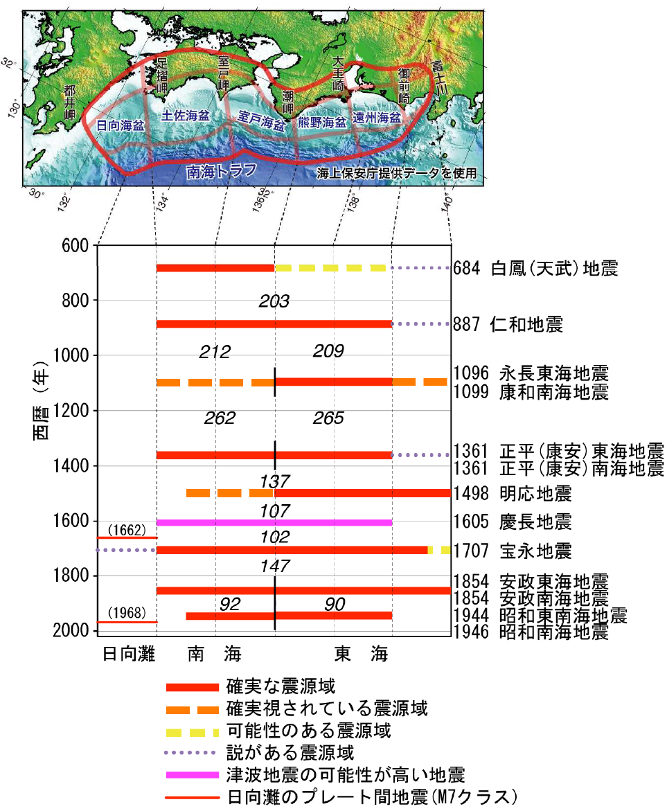
過去に発生した南海トラフ地震の震源域の時空間分布
Spatial and temporal distribution of the epicenter areas of past Nankai Trough earthquakes
(出典:「気象庁ホームページ」・「南海トラフの地震活動の長期評価(第二版)」(地震調査研究推進本部))
(Source: Japan Meteorological Agency (JMA )website,
“Long-term Evaluation of Seismic Activity in the Nankai Trough (Second Edition)” (Headquarters for Earthquake Research Promotion))
今回のまとめ
地震保険は、地震によって損失を被る「不確定な可能性」を保険料というコストとして「確定させる仕組み」である。この地震保険を活用することによって「企業経営の不確実性」を減じていくことは、重要な経営戦略である。
しかし、「地震保険」を利用したとしても、単なる地震による建物等の損壊というリスクだけではなく、南海トラフ巨大地震では、「建物の損壊にともなう、インフラの破壊、事業の長期中断による企業業績の落ち込み等の巨大な二次的リスクが発生する可能性」がある。このため、地震保険の「補償内容」も十分に吟味検討しなければならない。
また、日本の損害保険会社で引受けられる地震リスクの総量(引受キャパシティ)にも限界がある。政府が地震保険を最終的に引受ける、「個人の住宅・家財に関わる地震保険」でも、その総量は約11兆円と南海トラフ巨大地震で予想される損害額220兆円の20分の1、僅か5%にしか過ぎない規模だからである。「企業向け地震保険」に至っては、政府の補償はまったくの手付かずである。
だからこそ、「企業には、海外の地震保険の引受キャパシティを日本に持ってくる手段であるキャプティブが必要だ」と言える。東日本大震災のとき飛び交った「想定外」という言葉を地震後の役員会で発しないためにも、この「キャプティブ」という仕組みを上手く活用して、「地震保険を補償金額、補償内容、補償範囲の面から充実させること」が、今後30年以内に70~80%の確率で起きると政府が言明している「南海トラフ巨大地震」への対応としては、非常に重要な経営戦略になっているのである。
今回の和歌山での新たな発見は、「その対応をキャプティブによって迅速におこなうこと」を求めているのではないだろうか。
執筆・翻訳者:羽谷 信一郎
English Translation
RM75ー Discovery of traces of one of the largest earthquakes in history (Wakayama”The Hashigui-iwa”)
In Captive 9 (‘Kii Dainagon’ Wakayama), posted in this column on 30 June 2022, RM74 Preparing for ‘Risks Hidden in Place Names’, “A blue curved area can be seen to the south of Wakayama City, which is ‘Kainan City’ facing Wakanoura. On that spot is the following ‘Natural Disaster Lore Monument (Earthquake and Tsunami)’.” The following is an overview of the monument.
Outline
Monument name: Nankaido Earthquake Tsunami Inundation Level
Disaster name: Showa Nankai Earthquake
(21 December 1946)
Type of disaster: Earthquake/tsunami
Year erected 1991
Location :Nadaka, Kainan City, Wakayama Prefecture
Description of legend: This map shows the arrival and water level of the tsunami caused by the Showa Nankai Earthquake that occurred on 21 December 1946. In the Kainan area, the first wave arrived 40 minutes after the earthquake, followed by the second wave, which was the largest, with the tsunami reaching a height of 3.21 m deep in the bay.
1. new tsunami traces found in Wakayama
The 1707 Hoei Earthquake, estimated to be one of the largest earthquakes in Japan, is thought to have been caused by a triplet of earthquakes in the Tokai, Tonankai and Nankai seas. However, as there are no written records, it was only a ‘guess’, but an investigation of ‘tsunami deposits’ showing the history of land that experienced tsunamis in the past has led to the estimation that the estimated energy of the earthquake was greater than the magnitude (M8.6) of the earthquake.
On 12 September this year, a research team led by the National Institute of Advanced Industrial Science and Technology (AIST) investigated geological traces around the Hashigui-iwa, a scenic spot in the town of Kushimoto, Wakayama Prefecture, and “clarified that a tsunami larger than that of the 1707 Hoei Earthquake, which is also called the largest ever experienced along the Nankai Trough, hit this area. The institute’s website states that it “clarified that a tsunami larger than the 1707 Hoei Earthquake, the largest tsunami ever recorded along the Nankai Trough, hit this area”, and the media reported on this.
The Hashigui-iwa is a scenic spot where more than 40 rock pillars of various sizes stand along the coast, and huge rocks, estimated to weigh up to 85 tonnes, are scattered over 100 metres on the land side, presumably formed by the collapse of these pillars. A research team led by AIST estimated that the giant rocks were washed ashore by the tsunami and measured the location and size of some 1,300 rocks and conducted a tsunami simulation.
AIST’s website outlines the results of the research as follows.
The Hashigui-iwa, known for the rows of huge rocks that line the coast, is a rock formed by magma intrusion. The rocks are also composed of rocks derived from the same magma, so it is thought that they were separated from the Hashigui-iwa and moved to the surrounding area. The cause of the movement was assumed to be that the giant debris had been carried away from the piles by large tsunamis or storm surges in the past. Therefore, we measured the position and size of these large debris and calculated how large a tsunami would cause them to move. As a result, it was found that some of the giant debris along the Nankai Trough did not move even when subjected to a tsunami of the magnitude of the 1707 Hoei Earthquake, the largest tsunami in history. This means that a tsunami larger than the 1707 tsunami once struck the area and moved the giant debris. In order for all the giant debris to move, in addition to the 1707 earthquake, the branch fault at the offshore plate boundary would have to slip significantly or slip more than twice as much on the fault plane of the 1707 earthquake. Further details of the study were published in Tectonophysics on 6 September 2022.”
2. Nankai Trough giant earthquake
The JMA website describes a ‘Nankai Trough Earthquake’ as follows.
Nankai Trough earthquakes are large-scale earthquakes that have occurred repeatedly at intervals of approximately 100 to 150 years, with the epicentre area at the plate boundary between Suruga Bay and off the coast of Hyuga Sea. More than 70 years have passed since the last Nankai Trough earthquakes (Showa Tonankai Earthquake (1944) and Showa Nankai Earthquake (1946)) occurred, and the imminence of the next Nankai Trough earthquake is increasing.
‘Nankai Trough earthquakes’ have occurred at intervals of 200 years before the Middle Ages, when records were scarce, and at intervals of 100 to 150 years afterwards. A very recent example is the ‘Showa Tonankai Earthquake’, which occurred on 7 December 1944 and caused extensive damage in the Tokai region. However, it was not reported because of the wartime situation. It has long been estimated that there were areas with an intensity equivalent to intensity 7, but at the end of 2019, a team from Nagoya University reassessed the distribution of intensity in various regions due to this earthquake and found that “Nishio City in Aichi Prefecture, Kikugawa City and Fukuroi City in Shizuoka Prefecture had an intensity of ‘intensity The team’s result was reported as “Nishio City in Aichi Prefecture, and Kikugawa City and Fukuroi City in Shizuoka Prefecture were at ‘intensity 7’, and areas with large tremors require caution (for future major earthquakes)”.
The assumed epicentre of the Nankai Trough earthquake is divided into three areas. The Tokai earthquake has an assumed epicentre in the Shizuoka region, the Tonankai earthquake in Aichi, Mie and Wakayama, and the Nankai earthquake with an assumed epicentre extending westwards to off Miyazaki. Despite the time difference, as mentioned above, there is a high probability that these three epicentre regions will interlock, and it is predicted that this will be “a super earthquake of far greater magnitude than the Great East Japan Earthquake”.
The Cabinet Office has previously estimated that, in the event of the maximum shaking, an area with an intensity of 6 or higher on the Japanese seismic intensity scale would be spread over a wide area along the Pacific coast, with “more than 320,000 people killed and economic damage exceeding 220 trillion yen”. This was assumed to be the case. However, in May 2019, the number of deaths assumed out of this number was lowered to just over 230 000, stating that the reason was “influenced by the improved awareness of residents of tsunami evacuation after the Great East Japan Earthquake”, but also adding that “the assumption may increase again depending on the results of future surveys”.
In conventional earthquake damage estimates, the greatest emphasis was placed on ‘physical damage from shaking’, but due to the enormity of the tsunami damage caused by the Great East Japan Earthquake, various ‘tsunami countermeasures’ have been put in place to prepare for a massive Nankai Trough earthquake. However, these are only “measures that place the highest priority on reducing the number of victims by saving lives”, and it is difficult to say that sufficient measures, including insurance, have been taken in terms of economic countermeasures.
Summary of this issue
Earthquake insurance is a mechanism that “fixes” the “uncertain possibility” of losses due to earthquakes as a cost in the form of insurance premiums. It is an important management strategy to reduce the ‘uncertainty of corporate management’ by utilising earthquake insurance.
However, even if earthquake insurance is used, it is not just the risk of damage to buildings and other structures caused by earthquakes, but also the possibility of “huge secondary risks such as damage to buildings, destruction of infrastructure and a decline in corporate performance due to long-term business interruption” in the event of a major Nankai Trough earthquake, and therefore the contents of this earthquake insurance coverage must also be thoroughly examined. The contents of the insurance coverage must also be thoroughly examined and considered.
There are also limits to the total amount of earthquake risk (underwriting capacity) that can be underwritten by Japanese non-life insurance companies. Even in the case of earthquake insurance for individual houses and household goods, which is ultimately underwritten by the Government, the total amount is only about 11 trillion yen, or one twentieth of the 220 trillion yen in losses expected from a major Nankai Trough earthquake, or a mere 5% of the total amount of losses. Government compensation for “earthquake insurance for companies” is untouched.
This is why captives are needed, as a means of bringing “overseas earthquake insurance underwriting capacity” to Japan. In addition, in order to avoid the word ‘unforeseen’, which flew around at the time of the Great East Japan Earthquake, being uttered at post-earthquake board meetings, it is important to make good use of this ‘captive’ mechanism to ‘enhance earthquake insurance in terms of coverage amount, coverage content and coverage’, as the government has stated that there is a 70-80% probability that an earthquake will occur within the next 30 years. This should be a very important management strategy in response to the ‘Nankai Trough Earthquake’, which the Government has stated has a 70-80% probability of occurring within the next 30 years. The new findings in Wakayama may call for a rapid response.
Author/translator: Shinichiro Hatani