
キャプティブ 2023.12.03
CA55 フィリピンでの地震による津波が意味すること
Copyright © Shinichiro Hatani 2023 All rights reserved
For those who prefer to read this column in English, the Japanese text is followed by a British English translation, so please scroll down to the bottom of the Japanese text.
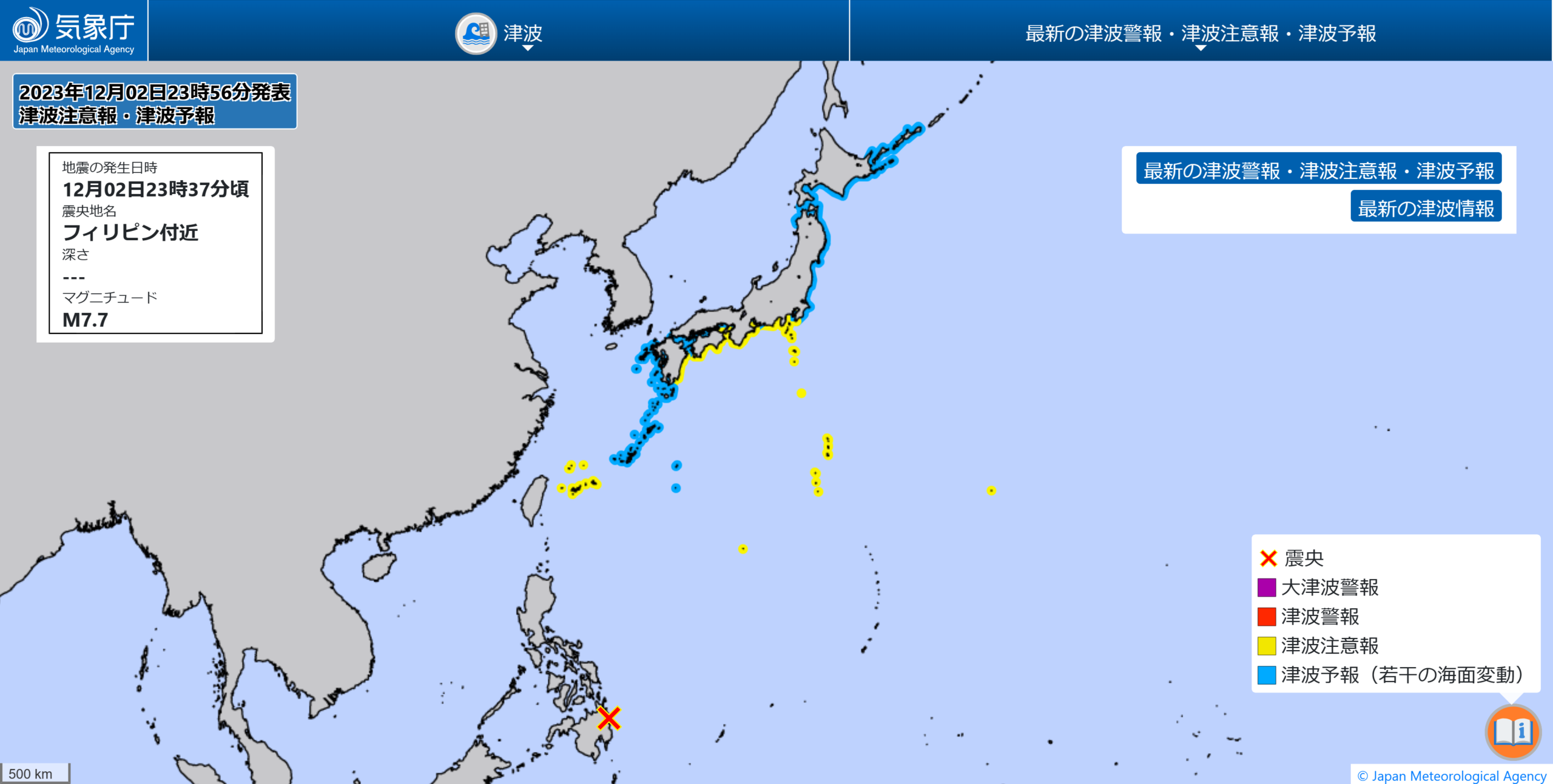
昨日、2023年12月2日、午後11時40分過ぎ、テレビ各局は一斉に「フィリピンで大規模な地震が発生したため、日本の太平洋沿岸部では津波が発生しますので注意してください」との津波注意報をテロップで流し始めた。
「時事通信」によると、「米地質調査所(USGS)がフィリピン南部のミンダナオ島で12月2日午後10時37分(日本時間同11時37分)ごろ、同島東部を震源とするマグニチュード(M)7.6の地震が発生した。」というものであった。その後、気象庁のホームページには以下が記載された。
令和5年12月2日23時37分頃のフィリピン付近の地震について(第2報)
報道発表日
令和5年12月3日
本文
地震の概要 発生時刻
(地震が発生した時刻)12月2日23時37分頃 マグニチュード 7.7(速報値) 場所及び深さ フィリピン付近 深さ不明 発震機構 東西方向に圧力軸を持つ逆断層型の地震(速報) 津波警報等の発表状況 津波注意報 千葉県内房 伊豆諸島 小笠原諸島 静岡県 愛知県外海 三重県南部 和歌山県 徳島県 高知県 宮崎県 鹿児島県東部 奄美群島・トカラ列島 宮古島・八重山地方 (防災上の留意事項)
津波が発生しており海の中や海岸付近は危険です。海の中にいる人はただちに海から上がって、海岸から離れてください。潮の流れが速い状態が続きますので、注意報が解除されるまで海に入ったり海岸に近付いたりしないようにしてください。
同ホームページの「地震情報 一覧」を見ると、今年5月に入って鹿児島県種子島、屋久島の南方、トカラ列島近海を震源とするマグニチュード3~4程度、震度1~3程度の地震がひっきりなしに起きているのが解る。震源の深さは「10km」、「プレート」が「マントル」に接すると考えられている深さで起きている、つまり「プレートの沈み込みによる地震」と推測できるものである。
また、同月、東京都新島、神津島近海を震央とする震源の深さ10kmでもマグニチュード5.3の地震が発生した。下の「2.ユーラシアプレート」の図に明らかなように、フィリピン海プレートが日本列島、伊豆半島に接する場所が震源である。

(出典:USGS, Washiucho) (Source: USGS, Washiucho)
1.フィリピン海プレート
これらの地震の前、本年2023年1月18日には、フィリピンの南にある、インドネシア中部のモルッカ海を震源とするマグニチュード(M)7.2の地震が起きている、そして昨日またマグニチュード(M)7.6ないし7.7の大地震が起きたのである。
これらの大地震が起きた「モルッカ海」は、上図の通り「フィリピン海プレートの最南端の尖った場所周辺の海域のこと」であるが、気になるのはこのフィリピン海プレートが、日本列島と接している場所が「南海トラフ」と言われる場所ということである。このマグニチュード7を越える大地震は、南海トラフが存在するフィリピン海プレート全体に少なからず波及することが予測できる規模の地震である。
以前、何度かこのコラムにも投稿したが、「テーブル」の一方に、ある力が加われば、そのエネルギーは同じテーブルに乗っているあらゆる食器に影響を与えることが容易に推測できる事象だからである。
上図のとおり、フィリピン海プレートは太平洋プレートと小笠原海溝、マリアナ海溝で、その北は日本海溝、ユーラシアプレートと接する西側は、南海トラフ、琉球海溝、フィリピン海溝、これらに囲まれた小さな海洋プレートである。
このフィリピン海プレートがユーラシアプレートに沈み込む日本列島の和歌山沖から九州宮崎沖までの一帯が南海トラフと言われる場所であり、懸念されている海溝型巨大地震、「南海トラフ巨大地震」の震源と目されている場所なのである。また、今年発生から100年を迎えた関東大震災も、フィリピン海プレートが北アメリカプレートに沈み込むことによって発生した地震である。
関東地方は北アメリカプレートに、フィリピン海プレート、太平洋プレート、この2つのプレートが沈み込む場所であり、そのため「大きな海溝型(プレート型)地震のリスクがある場所」である。プレートは時々刻々と動いている、小さな沈み込みの動きであっても地球規模のプレートが動く以上、地上には大きな影響、そのほとんどが「大地震」となって現れる。
「伊豆半島の合体活動」は現在でも続いている、その延長線上にある巨大な活火山が富士山である。富士山のマグマ溜まりに影響を与えないはずがない、富士山噴火の危険性は伊豆半島の動きと連動して高まっているのである。
筆者が大きな地震リスクへの対策として、「早急なキャプティブの設立」を声高に言い続けている理由の背景はここにある。
2.フィリピン海プレート周辺の地震
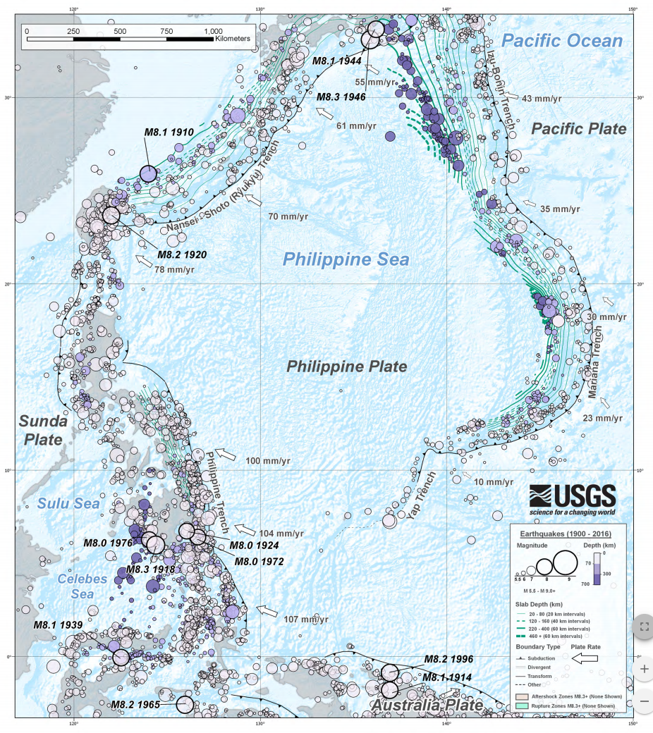
(出典:USGS) (Source: USGS)
上図は、米国内務省傘下の調査機関の一つ、1879年に設立された米国地質調査所(United States Geological Survey: USGS)が公開している、「1900年から2016年に掛けてフィリピン海プレート周辺で発生したマグニチュード(M)5.5以上の地震を記した図」である。北部(図の上部)に日本列島が見えるが、このフィリピン海プレートが他のプレートと接する場所で大きな地震が発生しているのが一目瞭然である。
日本列島周辺に記された「M8.1 1944」とは1944年12月7日発生した「昭和東南海地震」であり、「太平洋戦争中で、報道管制が引かれ『隠された』と言われているマグニチュード8.1の大地震」のことである。「南海トラフ巨大地震」の予測震源域の東半分一帯、駿河トラフと南海トラフ沿いを震源とする地震であった。また、「M8.3 1946」とは、終戦後の混乱のなか和歌山県沖を震源として1946年12月21日に発生したマグニチュード8.3の巨大地震、「昭和南海地震」のことである。
3.ユーラシアプレート
このフィリピン海プレートが大陸側のプレート、ユーラシアプレートに沈み込んでいる場所を更に詳しい図で見ると、このところ立て続けに起きている地震の発生要因が更に良く解る。
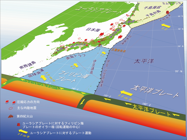
この図は、「国立研究開発法人 産業技術総合研究所(「産総研」)」のホームページから、「日本列島周辺のプレート運動と頻発する内陸地震 本州の広い範囲は東西方向に押されている(図中の赤矢印)」と題する図を引用したものである。
本年5月11日未明千葉県南部を震源とするマグニチュード5.4、震度5強の大きな地震でたたき起こされた方も多いのではないだろうか。上図を見ると、千葉県南部の地震、頻発しているトカラ列島近海の地震がフィリピン海プレートの動きによって起きているのが明確に解る。
問題は、千葉県とトカラ列島の間にある場所、「南海トラフ」である。小刻みなプレートの動きが小さな地震をフィリピン海プレートの北と北西部で発生させていて「地震のエネルギー」が少しずつ放出されているさまが見て取れるが、その間「南海トラフ」では地震の発生はこのところ無い。つまり「地震のエネルギーは放出されていない=溜まっている」ということが予測される。
今回のまとめ
「テーブル」で食事をしている時、急に誰かテーブルにドンと手を突いて立ち上がるとテーブル上のモノに何が起きるのだろうか。頑丈なテーブルであれば多少の振動が他の家族の方にある程度だろうが、もしそのテーブルが「柔らかな素材のテーブル」であればどうだろうか。みんなの前のテーブルはその影響で大きく持ち上がることになるだろう。
地球の外殻を構成するプレートは、表面は頑丈な岩石で構成されているが、乗っている土台は「マグマ=液状化した柔らかい岩石」である。上述の「テーブルの話」から、プレートのどこで起きた地震であってもそのプレートが接している日本列島の場所には確実に影響を与えるということが予測できる。
南海トラフ巨大地震の想定震源域は、3つに分かれている。静岡地方を想定震源域とする「東海地震」、愛知、三重、和歌山を想定震源域とする「東南海地震」、その以西宮崎沖まで伸びる想定震源域を持つ地震が「南海地震」である。時間差があっても、これら3つの震源域が連動する可能性が高く、更には「東日本大震災を遙かに凌ぐ、超巨大震災になる」と予測されている。
「災害は忘れた頃にやってくる」と言われている。今回のフィリピンの大地震は天の啓示ではないだろうか。
執筆・翻訳者:羽谷 信一郎
English Translation
Captive (CA)52- What the tsunami caused by the earthquake in the Philippines means
Yesterday, 2 December 2023, shortly after 11:40pm, television stations began simultaneously broadcasting a tsunami alert warning that a tsunami would be generated along the Pacific coast of Japan due to a major earthquake in the Philippines.
According to Jiji Press, “The US Geological Survey (USGS) reported a magnitude (M) 7.6 earthquake centred in the eastern part of Mindanao Island in the southern Philippines at around 10:37pm on 2 December.” This was the first time the earthquake had occurred. Subsequently, the JMA website made the following statement
Earthquake near the Philippines at 23:37 on 2 December 2023 (2nd report)
Date of press release
3 December 2023
Main text
Outline of the earthquake
Time of occurrence
(Time of earthquake) 23:37, 2 December
Magnitude 7.7 (preliminary)
Location and depth Near Philippines Depth unknown
Mechanism of occurrence Reverse fault earthquake with a pressure axis in the east-west direction (preliminary)
Tsunami warnings and other announcements
Tsunami warning Chiba Prefecture Uchibo Izu Islands Ogasawara Islands Shizuoka Prefecture Aichi Prefecture Outer Sea Mie Prefecture Southern part Wakayama Prefecture Tokushima Prefecture Kochi Prefecture Miyazaki Prefecture Eastern part Kagoshima Prefecture Amami Islands and Tokara Islands Miyako Island and Yaeyama Region
(Disaster prevention precautions)
A tsunami has been generated and it is dangerous in the sea and near the coast. People in the sea should get out of the sea and away from the coast immediately. The tidal currents will continue to be fast, so do not enter the sea or approach the coast until the warning is lifted.
The ‘Earthquake Information List’ on the website shows that since the beginning of May this year, earthquakes of magnitude 3-4 and intensity 1-3 have been occurring incessantly in the seas around Tanegashima and Yaku Island in Kagoshima Prefecture and the Tokara Archipelago, with epicentres in the southern part of Yaku Island. The epicentre is 10 km deep, at the depth at which the plate is thought to contact the mantle, which means that the earthquakes can be assumed to be caused by plate subduction.
In the same month, a magnitude 5.3 earthquake also occurred at a depth of 10 km with an epicentre near Niijima and Kozushima, Tokyo. As the ‘2. Eurasian Plate’ diagram below clearly shows, the epicentre is where the Philippine Sea Plate meets the Japanese Islands and the Izu Peninsula.
1. the Philippine Sea Plate
Prior to these earthquakes, on 18 January 2023, a magnitude (M) 7.2 earthquake centred in the Molucca Sea in central Indonesia, south of the Philippines, occurred, and yesterday another major earthquake of magnitude 7.6 to 7.7 occurred.
The Molucca Sea, where these major earthquakes occurred, is “the sea area around the southernmost tip of the Philippine Sea Plate”, as shown in the diagram above, but what is of interest is that the area where the Philippine Sea Plate meets the Japanese Islands is known as the Nankai Trough. A major earthquake of this magnitude over 7 can be expected to spread to the entire Philippine Sea Plate, where the Nankai Trough exists, in no small part.
As I have posted in this column several times before, this is because it can be easily assumed that if a certain force is applied to one side of a household ‘table’, for example, the energy will affect all the dishes on the same table.
As shown in the diagram above, the Philippine Sea Plate is surrounded by the Pacific Plate, the Ogasawara Trench and the Mariana Trench, with the Japan Trench to its north and the Nankai Trough, Ryukyu Trench and Philippine Trench to its west where it meets the Eurasian Plate, all of which are small oceanic plates.
The area from off Wakayama in the Japanese archipelago to off Miyazaki in Kyushu, where the Philippine Sea plate subducts into the Eurasian plate, is known as the Nankai Trough and is considered to be the epicentre of the Nankai Trough giant earthquake, a trench-type earthquake of great concern. The Great Kanto Earthquake, which marked the 100th anniversary of its occurrence this year, was also caused by the subduction of the Philippine Sea Plate into the North American Plate.
The Kanto region is a subduction zone of two plates, the Philippine Sea Plate and the Pacific Plate, on the North American Plate, and is therefore “at risk of major trench earthquakes”. The plates are moving from moment to moment, and even small subduction movements have a major impact on the ground, mostly in the form of ‘major earthquakes’, as long as the global plates are moving.
The Izu Peninsula is still undergoing coalescing activity, and a huge active volcano, Mt Fuji, is an extension of this activity. Fuji’s magma pools, and the risk of a Mt Fuji eruption is increasing in tandem with the movements of the Izu Peninsula.
This is the background to why the author has been vocal about the urgent establishment of a captive as a countermeasure against major seismic risks.
2. Earthquakes around the Philippine Sea Plate
The figure above is a chart showing earthquakes of magnitude (M) 5.5 or greater that occurred around the Philippine Sea Plate between 1900 and 2016, published by the United States Geological Survey (USGS), one of the research agencies under the US Department of the Interior, which was established in 1879. earthquakes of magnitude (M) 5.5 or greater that occurred around the Philippine Sea Plate between 1900 and 2016″, published by the USGS. The Japanese islands can be seen in the north (top of the diagram), and it is clear at a glance that major earthquakes have occurred where the Philippine Sea Plate meets other plates.
The ‘M8.1 1944’ marked around the Japanese Islands refers to the ‘Showa Tonankai Earthquake’ that occurred on 7 December 1944, ‘a major earthquake of magnitude 8.1 during the Pacific War, which is said to have been ‘hidden’ due to media control measures. The earthquake was centred along the Suruga Trough and Nankai Trough, in the eastern half of the predicted epicentre of the ‘Nankai Trough Earthquake’. The ‘M8.3 1946’ refers to the Showa Nankai Earthquake, a massive earthquake of magnitude 8.3 that occurred on 21 December 1946 with its epicentre off Wakayama Prefecture amid the chaos following the end of the war.
3. the Eurasian plate
A more detailed diagram of where the Philippine Sea Plate is subducting into the continental plate, the Eurasian Plate, provides further insight into the causes of the recent spate of earthquakes.
This diagram is taken from the website of the National Institute of Advanced Industrial Science and Technology (AIST), entitled ‘Plate movement around the Japanese Islands and frequent inland earthquakes: large areas of Honshu are being pushed in an east-west direction (red arrows in the diagram)’.
Many of you may have been shaken awake by a major earthquake with a magnitude of 5.4 on the Richter scale and a seismic intensity of 5 or more, centred in southern Chiba Prefecture in the early hours of 11 May this year. The diagram above clearly shows that the earthquake in southern Chiba Prefecture and the frequent earthquakes near the Tokara Archipelago are caused by the movement of the Philippine Sea Plate.
The problem is the Nankai Trough, the area between Chiba Prefecture and the Tokara Islands. Small plate movements are causing small earthquakes in the north and north-west of the Philippine Sea Plate, and it can be seen that ‘seismic energy’ is being released little by little, while there have been no earthquakes in the ‘Nankai Trough’ at the moment. In other words, it is predicted that “seismic energy is not being released = it is accumulating”.
Summary of this issue.
When eating at a ‘table’, what would happen to the objects on the table if someone suddenly stands up and puts their hand on the table with a thud? If the table is sturdy, there will be some vibration to the rest of the family, but what if the table is a ‘soft material table’? The table in front of everyone would be lifted significantly by the effect.
The plates that make up the outer shell of the Earth are made up of solid rock on the surface, but the base on which they rest is ‘magma = liquefied soft rock’. From the above-mentioned ‘table talk’, it can be predicted that an earthquake occurring anywhere on a plate will certainly affect the location of the Japanese Islands where that plate touches.
The assumed epicentre area of a major Nankai Trough earthquake is divided into three parts. The Tokai earthquake has an assumed epicentre in the Shizuoka region, the Tonankai earthquake has an assumed epicentre in Aichi, Mie and Wakayama, and the Nankai earthquake has an assumed epicentre extending westwards to off Miyazaki. Even though there is a time difference, there is a high possibility that these three epicentre areas will be linked, and furthermore, it is predicted that “this will be a supermassive earthquake, far greater than the Great East Japan Earthquake”.
It is said that “disasters come just when we have forgotten about them”. The recent major earthquake in the Philippines may be a sign from heaven.
Author/translator: Shinichiro Hatani