
キャプティブ 2024.04.18
CA 59「中央構造線」上、豊後水道で起きた4月17日の地震
目次
Copyright © Shinichiro Hatani 2024 All rights reserved
For those who prefer to read this column in English, the Japanese text is followed by a British English translation, so please scroll down to the bottom of the Japanese text.

(出典:USGS, Washiucho) (Source: USGS, Washiucho)
上図は 、United States Geological Survey、略称: USGS)、日本では「米国地質調査所」と呼ばれている、米国内務省に属する科学的研究機関が作成した図である。この図の左側、南から北に掛け、台湾方面から日本列島に掛るように拡がっている地球上のプレートがフィリピン海プレートと呼ばれているものである。
昨日、2024年4月17日(水)午後9時過ぎ、このフィリピン海プレートの南側下部、インドネシアのルアング火山で大規模な噴火があり、オーストラリアのダーウィンにある航空路火山灰情報センター(VAAC)によると、「噴煙が高度約1万9000mに到達していると推定される」と報告された。
そして、午後11時14分頃、フィリピン海プレートの北側、愛媛県南予と高知県西部で「最大震度6弱」を観測する地震があった。愛媛または高知で震度6弱以上の揺れが観測されたのは、1919年の統計開始以来初めて。気象庁は、「震源は豊後水道で、震源の深さは約50キロ、地震の規模はマグニチュード(M)6.4」と「速報値」を発表、後に、震源の深さは38キロ、マグニチュード(M)はマグニチュード(M)6.4の地震規模の2倍のエネルギーを持つ、マグニチュード(M)6.6と訂正された。
この地震による津波の心配はなく、「南海トラフ沿いの地震に関する評価検討会は開催しない」との報道が様々なメディアでなされた。

(出典:気象庁ホームページ)
1.南海トラフ巨大地震を引き起こすフィリピン海プレートの動き
本コラムでは、南海トラフ巨大地震の主因と見做されている、フィリピン海プレートの動きによる地震発生の可能性について何度か取り上げてきた。
フィリピン海プレートは、上図のように、太平洋プレートと接する東側は、小笠原海溝、マリアナ海溝その北は日本海溝、ユーラシアプレートと接する西側は、南海トラフ、琉球海溝、フィリピン海溝、これらに囲まれた小さな海洋プレートである。
フィリピン海プレートがユーラシアプレートに沈み込む、日本列島の和歌山沖から九州宮崎沖までの一帯が南海トラフと言われる場所であり、海溝型巨大地震「南海トラフ巨大地震」の震源域と懸念されている場所である。また、1923年発生した関東大震災も、フィリピン海プレートが北アメリカプレートに沈み込むことによって発生した地震である。
関東地方は北アメリカプレートに、フィリピン海プレート、太平洋プレート、この2つのプレートが沈み込む場所であり、そのため「大きな海溝型(プレート型)地震のリスクが存在する場所」である。プレートは時々刻々と動いている、小さな沈み込みの動きであっても地球規模のプレートが動く以上、地上には大きな影響、そのほとんどが「大地震」となって現れる。
何度か、このプレートを「テーブル」に例えてきたが、テーブルの動きはテーブル全体に影響を及ぼす。「インドネシアの火山活動がプレート及びその境界を刺激したのではないか」と筆者は懸念している、予測されている超巨大地震、南海トラフ地震を強く懸念しているからである。
南海トラフ地震の想定震源域は、3つに分かれている。静岡地方を想定震源域とする地震「東海地震」、愛知、三重、和歌山を想定する地震「東南海地震」、その以西宮崎沖まで伸びる想定震源域を持つ地震「南海地震」である。時間差があっても、これら3つの震源域が連動する可能性が高いと言われていて、「東日本大震災を遙かに凌ぐ、超巨大震災になる」と予測されているものである。
2.「中央構造線」上で起きた地震
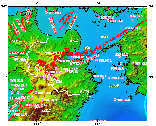
(出典:政府「地震調査研究推進本部」のホームページ内「大分県の地震活動の特徴」)
日本列島の真ん中にある大地溝帯、「フォッサマグナ」を境にして、西半分は「ユーラシアプレート」、東半分は「北米プレート」とその「土台」が別れている。
更に、RM73「地名に潜むリスク」へ備えるキャプティブ 7(「瓜生島沈没」大分)に詳しく記したが、大分県の有名な温泉地である由布院に源を発し別府湾に注ぎ込む「大分川」の下を日本列島の背骨のように、この長さ1,000kmに及ぶ長大な大断層帯「中央構造線」が通っている。
中央構造線は、茨城から関東を通り、諏訪を経て、三重、和歌山、さらに四国を縦断して大分に入り、九州の八代、熊本を経て太平洋へ抜ける長大な大断層帯である。九州、大分県から熊本県に至る一帯を走る中央構造線上には、別府温泉をはじめ湯布院と有名な温泉地が連なっていて、この温泉地熱現象には新しい火山活動や地震が活発な地域である。
「古代地名語源辞典」(楠原祐介ほか(編著) 東京堂出版(刊))には、大分(おおいた)は「おほいた」と読み「オホは美祢(みね)イタはキダの転で、『刻まれたような地形』、つまり段丘を呼んだ地名である。」と記されている。
この「段丘」とは、地殻変動等によってもともと海底や川底であった場所が隆起することによって形成される「隆起地帯」に発達した地形であり、プレートが複雑に入り組んでいて地震の多い地域で多くみられる地形である。
上図は、政府「地震調査研究推進本部」のホームページにある「大分県の地震活動の特徴」のページから引用したものであるが、真ん中にある「別府湾」下に「中央構造線断層帯」と赤字で記されているものである。
その上に、「1596 M7.0」とあるものが「慶長豊後地震」と呼ばれるものであり、「南蛮船の見える町―わがバテレン・宗麟・瓜生島 加藤 知弘 (著) 石風社(刊)」には、「湯布院の奥から、大分市内、そして別府湾に注ぐ大分川、この河口の沖合に陸地と砂州で繋がった島、南蛮貿易で栄えた『瓜生島』と『久光島』があったが、この2島が、1596年9月発生した『慶長豊後地震』で、一夜にして海に沈み、島の住人の多くが犠牲になった」という「伝説」が記されている。
別府湾に沈んだ「瓜生島」のこの話が語りつがれてきたが、歴史的資料が乏しく、あくまでも「瓜生島沈没」は伝説の域を出なかった。しかし、近年様々な研究者によってその実態が解き明かされつつあり、かなりの角度でその信憑性が論議されるようになってきている。
昨日、4月17日の「震源:豊後水道、震源の深さ:約50キロ、地震の規模:マグニチュード(M)6.4の地震」はこの場所で起きたのである。
今回のまとめ
グローバル・リンクは、「地震リスクへの対応を主目的とするキャプティブ」の設立を推奨し続けてきた。その理由は、地震リスク以外の大半のリスクであれば、世界的にも評価の高い日本の損害保険会社であれば相応の保険料で十分に補償できるからである。
しかし、地震リスクは、日本の損害保険会社の引受力(キャパシティ)では、企業が求める補償を十分に受けることは非常に困難である。また、そのコスト(保険料)はかなりのレベルとなり、「キャプティブを設立して世界的規模を有する信用のおける海外の再保険会社から引受力(キャパシティ)を得た方が、遙かに廉価な保険料で、遙かに大きな金額の地震リスクの補償を受けることができるから」である。
キャプティブの設立までには、通常数ヶ月以上掛かるという現実がある。大地震が起きてから、「やっておけば良かった」と後悔しないためにも、一刻も早く取り組むことが肝要ではないかと感じている。
2011年3月11日の東日本大震災から13年を経過して、またぞろ企業が「想定外」との言葉を発することはできない。ステークホルダーへの責務を果たす役割を担うのが経営陣だからである。その「参謀役」の部門が果たさなければならない喫緊の責務は「巨大地震リスクへの対応」であると筆者は考えている。
「南海トラフ巨大地震」の足音が近づいてきたと考えられる今こそ、キャプティブの設立によって海外の巨大再保険会社のキャパシティ(保険引受力)を得てリスクマネジメント態勢を固める時期ではないだろうか。
しかし、近年では、この地震リスクに加えて場合によってはそれをしのぐ規模の損害になる可能性のあるリスク、サイバーリスクの発生及び巨大な損害の報告なされるようになってきた。
このためグローバル・リンクでは、本年2024年7月1日から、世界最大級の再保険会社との緊密な業務提携関係のもと、「サイバー保険キャプティブ」の設立を強力に推進していくこととなった。
欧米と比べると、地震保険分野より、更に再保険確保が大きく劣後していて、非常に狭い補償内容、また小さな補償金額でしか提供されてこなかった、その為に、サイバー保険の普及が非常に遅れていると様々なメディアで報道されてきたが、キャプティブを活用して、大きなサイバー保険の補償枠を確保、また補償内容の大きな充実を図れると考えている。
執筆・翻訳者:羽谷 信一郎
English Translation
Captive (CA) 59 – 17 April earthquake in the Bungo Channel on the ‘Median Tectonic Line’ion
The map above was produced by the United States Geological Survey (USGS), known in Japan as the ‘US Geological Survey’, a scientific research organisation affiliated with the US Department of the Interior. The plate on the left side of the diagram, which extends from south to north, from Taiwan to the Japanese islands, is called the Philippine Sea Plate.
Yesterday, 17 April 2024 (Wednesday), shortly after 9pm, there was a major eruption at the lower southern part of the Philippine Sea Plate, the Luangue volcano in Indonesia, and the Volcanic Ash Information Centre (VAAC) in Darwin, Australia, reported that the plume was estimated to have reached an altitude of about 19 000 m. The report said.
Then, at around 11:14pm, an earthquake measuring ‘maximum intensity 6’ occurred on the northern side of the Philippine Sea Plate, in Nanyo, Ehime Prefecture, and western Kochi Prefecture. The JMA announced that the epicentre was in the Bungo Channel, with an epicentre depth of about 50 km and an earthquake magnitude (M) of 6.4. There was no concern about tsunamis from this earthquake, and it was reported in various media outlets that ‘the evaluation study group on earthquakes along the Nankai Trough will not be held’.
1. Movement of the Philippine Sea Plate causing a huge Nankai Trough earthquake
This column has discussed several times the possibility of earthquakes occurring due to the movement of the Philippine Sea Plate, which is regarded as the main cause of the Nankai Trough giant earthquake.
As shown in the diagram above, the Philippine Sea Plate is a small oceanic plate bounded by the Ogasawara Trench and Mariana Trench to the east where it meets the Pacific Plate, the Japan Trench to the north, and the Nankai Trough, Ryukyu Trench and Philippine Trench to the west where it meets the Eurasian Plate.
The area from off Wakayama in the Japanese archipelago to off Miyazaki in Kyushu, where the Philippine Sea plate subducts into the Eurasian plate, is known as the Nankai Trough, and is feared to be the epicentre of a trench-type giant earthquake, the Nankai Trough Giant Earthquake. The Great Kanto Earthquake of 1923 was also caused by the subduction of the Philippine Sea Plate into the North American Plate.
The Kanto region is a subduction zone of two plates, the Philippine Sea Plate and the Pacific Plate, on the North American Plate, and is therefore “at risk of major trench earthquakes”. The plate is moving from time to time, and even small subduction movements, as long as the global plate is moving, have a significant impact on the ground, most of which will manifest themselves as ‘major earthquakes’.
The plate has been likened to a ‘table’ on several occasions, and movements of the table affect the whole table. The author is concerned that “volcanic activity in Indonesia may have stimulated the plate and its boundaries”, because he is strongly concerned about the predicted super-mega earthquake, the Nankai Trough earthquake.
The assumed epicentre area of the Nankai Trough earthquake is divided into three parts. The Tokai earthquake, with an assumed epicentre in the Shizuoka region; the Tonankai earthquake, with an assumed epicentre in Aichi, Mie and Wakayama; and the Nankai earthquake, with an assumed epicentre extending westwards to off Miyazaki. Even if there is a time lag, there is a high probability that these three epicentre regions will interlock, and the earthquake is predicted to be “a super earthquake of far greater magnitude than the Great East Japan Earthquake”.
2. Earthquakes occurring on the Median Tectonic Line
The Great Rift Valley in the middle of the Japanese archipelago, the “Fossa Magna”, separates the western half from the “Eurasian Plate” and the eastern half from the “North American Plate” and their “foundations”.
Furthermore, as described in detail in Captive 7 (‘Uryu Island sinking’ Oita https://glc-tokyo.com/news_column/p7936/) in preparation for RM73 ‘Risks hidden in place names’, the ‘Oita River’, which originates in Yufuin, a famous hot spring resort in Oita Prefecture, and flows into Beppu Bay, runs under the Japanese archipelago. Like a backbone of the Japanese archipelago, the Median Tectonic Line, a great fault zone 1,000 km long, runs beneath the Oita River, which originates in the famous hot springs of Yufuin in Oita Prefecture and empties into Beppu Bay.
The Median Tectonic Line is a great fault zone that runs from Ibaraki, through the Kanto region, through Suwa, Mie and Wakayama, across Shikoku, into Oita, through Yatsushiro and Kumamoto in Kyushu and out into the Pacific Ocean. On the Median Tectonic Line, which runs through the area from Oita to Kumamoto prefectures in Kyushu, there is a series of famous hot spring resorts such as Beppu Onsen and Yufuin, and this hot spring geothermal phenomenon is an active area with new volcanic activity and earthquakes.
In the Dictionary of the Etymology of Ancient Place Names (edited by Yusuke Kusuhara et al., Tokyo Do Publishing), Oita is read as Ohoita, “Oho is a transcription of Mine and Ita is a transcription of Kida, a place name for a ‘landform like a carved terrain’, or terrace.” It is written as follows.
Terraces are landforms that develop in uplift zones, which are formed by the uplift of areas that were originally the seabed or river bottom due to tectonic movements, etc., and are often found in regions where plates are intricately interconnected and earthquakes are frequent.
The figure above is taken from the ‘Characteristics of seismic activity in Oita Prefecture’ page on the website of the government’s Headquarters for Earthquake Research Promotion, where ‘Median Tectonic Line Fault Zone’ is marked in red below ‘Beppu Bay’ in the middle.
Above that, the ‘1596 M7.0’ is called the ‘Keicho-Bungo Earthquake’, and in ‘A Town with a View of Nanban Ships – My Bateren, Sorin and Uryu Island’, Tomohiro Kato (author), published by Ishikaze-sha, states that ‘From behind Yufuin, Oita City and the Oita River flowing into Beppu Bay, the land and the island connected to the land offshore of this river mouth are located. These two islands sank into the sea overnight during the Keicho Bungo Earthquake of September 1596, killing many of the island’s inhabitants.
This story of Uryu Island sinking in Beppu Bay has been passed down through the ages, but due to a lack of historical data, the ‘sinking of Uryu Island’ has remained a legend. In recent years, however, various researchers have begun to uncover the reality of the story, and its veracity is being debated from a number of angles.
Yesterday, 17 April, an earthquake of epicentre: Bungo Channel, epicentre depth: 50 km, magnitude (M) 6.4 occurred at this location.
Summary of this issue
Global Link has continued to recommend the establishment of ‘captives whose primary purpose is to address seismic risk’. The reason for this is that most risks other than earthquake risk can be adequately covered at reasonable premiums by Japanese non-life insurance companies, which have a good reputation worldwide.
However, for earthquake risks, it is extremely difficult for Japanese non-life insurers to provide sufficient compensation for the risks that companies require, given their underwriting capacity. The costs (premiums) are also quite high, and “it would be far cheaper to establish a captive and obtain underwriting capacity from a reputable overseas reinsurer with a global scale, which would provide a much larger amount of earthquake risk coverage at much lower premiums”.
The reality is that it usually takes several months or more to set up a captive. We feel that it is essential to work on this as soon as possible to avoid regretting what we should have done after a major earthquake has occurred.
Thirteen years after the Great East Japan Earthquake of 11 March 2011, companies cannot again utter the words ‘unexpected’. This is because it is the management team that is responsible for fulfilling its responsibilities to stakeholders. The author believes that the most urgent responsibility that the ‘General Staff’ department must fulfil is to ‘respond to the risk of a major earthquake’.
It is widely known that the capacity (underwriting capacity) of Japanese non-life insurance companies is not sufficient to cope with the risk of a major earthquake. It may be time to consolidate the risk management posture by gaining the capacity of giant overseas reinsurers through the establishment of a captive.
However, in recent years, in addition to earthquake risk, there have been reports of the occurrence of cyber risk, a risk that could in some cases be even larger than earthquake risk, as well as reports of huge losses.
For this reason, Global Link has decided to strongly promote the establishment of a ‘cyber insurance captive’ from July 2024, in close cooperation with one of the world’s largest reinsurers.
Compared to Europe and the US, the reinsurance sector has been significantly inferior to the earthquake insurance sector, with very narrow coverage and small amounts of compensation, which has led to various media reports that cyber insurance has been very slow to spread. The captive will be used to secure a large cyber insurance coverage and to greatly enhance the coverage.
Author/translator: Shinichiro Hatani