
キャプティブ 2022.11.30
CA44 なぜキャプティブを持つべきなのか(迫り来る超巨大地震への備え)
目次
For those who prefer to read this column in English, the Japanese text is followed by a British English translation, so please scroll down to the bottom of the Japanese text.
11月24日配信された「AERA dot.」に、「巨大地震、津波から逃れても『寒さ』が敵に 低体温症の危険から身を守る備えとは?」(筆者:野村昌二氏)が掲載されていた。このところ各地で地震が続いており、「日本海溝・千島海溝地震」に関するこの記事を興味深く読んだ、その一部を引用する。
■東日本大震災を上回る
二つの地震を巡っては昨年12月、内閣府が公表した被害想定が衝撃を与えた。
冬の深夜に日本海溝でM9.1の地震が発生した際、北海道えりも町や岩手県宮古市で高さ約30メートルの巨大津波が襲い、最大で約19万9千人が死亡すると試算したのだ。死者数は北海道が最も多く約13万7千人、青森県は4万人超、岩手県は1万人超を数える。建物全壊は22万棟、経済被害は31兆3千億円に及ぶ。一方、千島海溝地震でも、M9.3の地震で死者は最大約10万人とされる。これらの規模は、死者1万5900人を出した東日本大震災をはるかに上回る。
死者のほとんどは津波に起因するが、被害を増幅させる要因に「寒さ」と「積雪」がある。北海道東部の太平洋に面した浜中町。防災対策室の串田之宣(ゆきのり)係長は言う。
「わずか10分の避難開始の遅れが、生死を分けかねない」
町は、国の想定では最大23メートルの津波が襲うとされている。昨年10月、町では徒歩で高台に逃げる津波避難訓練を実施した。町民約500人が参加し、そのうち10~90代の50人に全地球測位システム(GPS)端末を携帯してもらい避難にかかる時間を分析した。その結果、地震発生から5分以内に避難を開始すれば、津波到達前に全員が安全に避難できた。だが、避難行動が10分遅れ15分後に開始した場合、ほとんどの避難者が浸水区域を脱することができなかったのだ。
このシミュレーションを作成した、地方独立行政法人「北海道立総合研究機構」の戸松誠研究主幹(地域防災)は指摘する。
「冬場の避難は、暖かい格好で避難しなければいけないなど、相対として避難時間が遅くなります」
一般的に日中の避難は、地震発生から避難開始まで約5分といわれる。だが、寒冷地の場合、防寒着など上着を着るための時間がかかる。また、いざ避難を始めても積雪の影響で時間がかかることになる。
(出典:AERA dot.:「巨大地震、津波から逃れても『寒さ』が敵に 低体温症の危険から身を守る備えとは?」(筆者:野村昌二氏))
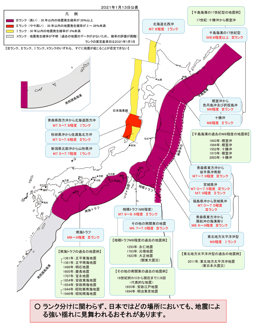
出典:「主な海溝型地震の評価結果」(地震調査研究推進本部)
Source: “Evaluation Results of Major Trench-Type Earthquakes”
(Earthquake Research Promotion Headquarters)
1.日本海溝・千島海溝巨大地震に対してキャプティブが果たす効用
「キャプティブ」は、「地震リスクに対するリスクマネジメント・ツールとして大きな効用を発揮する存在」であるが、対応する地震リスクの規模が大きければ大きいほどその効用は高くなる、理由は地震が発生した場合の損害額、被害額が大きくなるからである。
さらに、地震の規模が大きくなると、直接的な損害だけではなくインフラが受ける被害も大きくなり、地震から復興しようとする企業にとっては、企業業績回復への足枷になるリスクが大きくなり、「地震リスクへの十分な備えと補償」が必要となるからである。
こうしたことから、キャプティブは、日本海溝・千島海溝巨大地震、南海トラフ巨大地震等、これら「海溝型地震」に備えようとする企業にとっては、必須の企業戦略、リスクマネジメント・ツールと言われている。
大きな被害をもたらした1995年の阪神・淡路大震災は、マグニチュード(M)7.3の地上の断層が揺れた「断層型地震」であったが、「海溝型地震」であった2011年の東日本大震災のマグニチュード(M)は9.0であった。この「海溝型地震」の規模・エネルギー量は阪神・淡路大震災の300倍以上の数値である。海溝型地震が如何に巨大な地震になるかが解る。
いま、冒頭の図、「主な海溝型地震の評価結果」(地震調査研究推進本部)に明らかなように、南海トラフ巨大地震とともに、危惧されているもう一つの海溝型巨大地震は、政府中央防災会議が昨年2021年12月21日にその被害想定を発表した、「日本海溝・千島海溝沿いの巨大地震 」である。地震規模の想定は「M8.8以上」であり、同報告の中で「地震の発生確率が高く30年以内の地震発生率が26%以上」とされている地震である。
17世紀に、同じ千島海溝で巨大地震が発生したことが、津波堆積物の調査から判明したが、それ以前にも、300~400年の周期で大津波を伴う巨大地震が千島海溝では発生していた。
一方、日本海溝で起きた巨大地震の筆頭は、2011年の東日本大震災であるが、政府が発表した、「令和3年 12 月 21 日」付け「中央防災会議 防災対策実行会議 日本海溝・千島海溝沿いの巨大地震 対策検討ワーキンググループ」には、以下のような被害想定が記されている。
「日本海溝モデル」、つまり震源が日本海溝の場合、北海道の沖合から岩手県沖にかけてM9.1の巨大地震が発生、岩手県宮古市では29.7mの大津波が発生すると想定している。地震の発生時期、住民の避難状況から、6つのシナリオを想定しているが、冬の深夜に地震が起きた場合には、住民の早期避難も難しいため、犠牲者は北海道で13万7千人、青森県4万1千人、岩手県1万1千人、宮城県8500人、他県も合わせて合計19万9000人と推定、経済被害は31兆3千億円に及ぶと推計している。
「千島海溝モデル」では北海道襟裳岬の東沖合を震源域と想定している。このモデルでは、日本海溝モデルよりも地震の規模は更に大きく東日本大震災を上回るM9.3の地震が発生するとしている。この巨大地震によって、最大で27.9mの大津波が押し寄せ、犠牲者は北海道で8万5千人、他県も含めて合計で10万人と推定、経済被害は16兆7千億円に及ぶと推定するものである。
甚大な被害を引き起す「日本・千島海溝巨大地震」が、30年以内に26%以上の確率で地震が発生するという被害予測を国が出しているのである。果たして、その「備え」は十分であろうか。
2.「津波の語り部」
「国立研究開発法人産業技術総合研究所」(産総研)は、東日本大震災の前、2010年に「450〜800年間隔で東北地方を津波が襲っていたこと」、そしてそのために「今後も津波を伴う大地震が発生する可能性があること」を予見して、その研究結果を国に報告していた。しかし、この研究報告が広く人々の目に触れることになったのは、残念ながら東日本大震災が起きた後であった。それ以前の政府の「中央防災会議」に於ける「地震予知」では、数理的な解析を主とする地震学に偏重する傾向が強かったため大きく取り上げられることはなかったからである。
この反省から、その後の「中央防災会議」では、「古文書の分析や津波堆積物・海岸・地形調査によって、想定地震や津波被害を設定すること。地震学、地質学、考古学、歴史学などあらゆる見地から地震研究を充実させることを検討すべき」という趣旨の提言がまとめられた。
一般的に、地震の中長期予測については、地震学を基に、古来の文献記録や活断層の調査等を加えてなされてきたが、東日本大震災を「予見」した産総研では、それまであまり注目されてこなかった津波堆積物の調査をおこなうことによって、「その地質構成から過去に発生した地震の規模や津波の大きさ」を見極めた。「津波堆積物」とは、津波によって海底の砂などが陸上に押し上げられ、陸上の地層に「砂層」として残されたものである。この津波堆積物のボーリング調査をおこない、発生した地震の津波の高さ、浸水域等の被害の状況を「文献に記されていない過去の地震の証拠」として明示するものである。
平安時代、菅原道真を中心に編纂された「日本三代実録」には、東北地方で869年に発生した「貞観地震」と「貞観津波」について記されている。30年以上前には、既に貞観津波による津波堆積物が発見されていたが、「どこが震源なのか」が不明だったため、「地震調査研究推進本部」による海溝型地震の長期評価からは外されていた。その後、産総研は、仙台平野の地層の堆積物から、1000年以上に渡るこの土地の様子を調べ、貞観津波によるおおよその浸水域を推測、その結果、その浸水域は、それまでに観測されたどの津波よりも巨大であったことが判明した。
1707年に起きた「宝永地震」は、「東海、東南海、南海」の三連動地震が発生したものと考えられている。しかし、文献上の記録が無いため、あくまでも「推測」の域を出なかったが、役だったのが過去に津波を経験した土地の歴史を示す「津波堆積物」の調査であった。2011年から産総研が実施した静岡県西部の太田川流域での調査の結果、7世紀末、9世紀末に東海地震が起きたことを示す津波堆積物を発見することができたのである。
また、「津波堆積物の分布状況」から浸水域を見極めることができ、その結果過去の津波の規模も推定できるようになった。さらに、浸水域、津波堆積物の量等から、津波の規模も推定でき、この津波の大きさによって、「震源を推測、特定できる」ようになったのである。このように、津波堆積物は、「過去の地震の語り部」として、地震のリスクを現代の人々に伝えている。

3.地震の大きさ
地震の規模、大きさ、エネルギーを表わす単位にマグニチュードがある。このマグニチュードは、1つ大きくなると地震のエネルギーは約30倍、マグニチュードが2つ違うと地震のエネルギーは約1,000倍(≒30×30倍)、マグニチュードが3つ大きくなると地震のエネルギーは約30,000倍(≒30×30×30倍)になる。
マグニチュード0.1の差はエネルギーでは約1.4倍の差、マグニチュードが0.2違うだけでその地震の規模は約2倍(101.5×0.2 = 100.3 ≒ 1.995)となる。「日本・千島海溝巨大地震」の規模は東日本大震災を超える規模の巨大地震と言われている理由は、東日本大震災のマグニチュードは9.0に対して、「千島海溝モデル」のマグニチュードは9.3、つまり「日本・千島海溝巨大地震」(千島海溝モデル)の地震エネルギー量は、未曾有の被害をもたらした「東日本大震災」の約2.8倍ものエネルギー量の超巨大地震となるのである。
4.キャプティブの必要性
このような超巨大地震の場合、当然その被害も甚大になるため、地震保険の備えとしては、「超巨大地震による損害額へも対応した地震保険を準備する必要」がある。しかし、日本の3メガ損保グループと言えども、それほど巨額の補償額を提供することは極めて困難、つまり「日本国内では十分な地震保険キャパシティ(引受力)の確保が困難である」のが実状なのである。
だからこそ、損保会社任せにせず、企業の自助努力として、キャプティブを介して海外の保険市場へのアプローチをおこなうことが企業戦略の上からは重要だと言われているのである。キャプティブを設立して、海外の再保険会社からできるだけ多くの再保険サポートを得て、日本の損害保険会社が自ら提供できる補償額(キャパシティ)を補完していくことで、巨大な損害額に対応していくことができるからである。
今回のまとめ
より多くの地震保険キャパシティを確保するためには、一社ではなく、複数以上の再保険会社のサポートを確保する必要がある。
そのためには、「単純な地震保険の再保険手配」ではなく、「レイヤリング」という損害保険の専門的な引受技法によっておこなう必要がある。こういう大規模なキャパシティを確保するキャプティブの設立には、再保険マーケットにも通暁する非常に専門的なキャプティブの設立・運営コンサルティング会社を起用する必要と言われる所以がここにある。
損害保険には、必ず付帯されている契約条件に「免責金額」がある。損害保険に関わることの無い方にとって、「なぜこんな小さな金額を免責金額として付けているのか」と疑問に思うことも多いであろう。しかし、この免責金額を付けるか付けないかが、「その保険の引受の可否さえ決めてしまう要素」になる。
損害保険業では、「保険会社が受け取る保険料から、万が一の事故の際に支払う保険金、そしてそのための人件費等の事業費を差し引いてプラス」になっていれば、「事業から収益があがっている=事業継続への青信号」となるが、これがマイナスであれば「その事業からの撤退も視野」に入れなければならなくなる。
勿論、事故が起きた際に支払われる「保険金」が、この「収支の計算式」では一番大きな要素となるが、次は「人件費」である。営業は、インターネット等を介することを含めて省力化、省コスト化ができる分野であるが、「保険金の支払い」に関する業務、「査定(損害サービス)業務」は、なかなかこうはいかない。どうしても「人間の目が必要」な業務分野である。AIに取って代わられる部分が、非常に少ない分野なのである。特に企業保険分野に於いては。だからこそ、「免責金額」を付帯することによって、「小損害を保険支払いの対象から外す=損害サービスの人件費のカット」ということをしているのである。
「レイヤリング(レイヤー方式)」とは、この「免責金額を非常に大きくする」という考え方に似ている手法である。引受保険会社が、単独で引受が難しいリスク、また保険金額やてん補限度額が大きくて、一社では引受けられないリスクに関して、「保険金額やてん補限度額を数段階の階層(レイヤー)に分け、再保険を引受ける各再保険会社が独立して階層(レイヤー)の引受条件を決め、その階層部分を引き受けてもらう方式」である。
レイヤリング(レイヤー方式)は、それぞれの再保険会社の考え方(引受姿勢)を見極めて、レイヤー上層部または下層部かを引受けてもらうかを決めていく。こうすることにより、保険料率や提供できる保険引受枠に大きな差が出ることが多く、各保険会社の特長を活かしながら保険プログラム全体を低廉な再保険料で構築できる方式にすることができるのである。
単純に「割合(%)を出す再保険」(クオーター・シェア方式)で、キャプティブからの再保険をロンドン・マーケットで探しても、「日本・千島海溝巨大地震」に備えるような高額の補償枠を見つけることは難しい。その時に、活かせる保険技術、再保険技術がこのレイヤリングなのである。
キャプティブからのロンドン・マーケットへの再保険は、この「レイヤリング」方式を使って何層にも別けてそれぞれ得意とする再保険会社を選択、交渉することが重要であり、このためには、「世界最大の再保険市場である、ロンドン・マーケットに関する、確かな、また豊富な知見がキャプティブ・コンサルティング会社には必要である」ということである。
執筆・翻訳者:羽谷 信一郎
English Translation
Captive (CA) 44 -Why you should have a captive (Preparing for a massive oncoming earthquake)
The 24 November issue of AERA dot. carried the article “Even if you escaped a huge earthquake and tsunami, the cold can still be your enemy: How can you prepare to protect yourself from the dangers of hypothermia? (Author: Shoji Nomura). The article on the “Japan Trench and Kuril Islands Trench Earthquakes” was interesting to read as earthquakes have been occurring in many places recently.
■Exceeding the Great East Japan Earthquake.
The Cabinet Office’s damage estimates for the two earthquakes released in December last year were shocking.
It estimated that if a 9.1 magnitude earthquake struck the Japan Trench late in the winter, a huge tsunami of about 30 metres high would hit the towns of Erimo in Hokkaido and Miyako in Iwate Prefecture, killing up to 199,000 people. Hokkaido had the highest death toll at around 137,000, Aomori over 40,000 and Iwate over 10,000. The total number of buildings destroyed is estimated at 220,000 and the economic damage at 31.3 trillion yen. Meanwhile, the maximum death toll from a 9.3 magnitude earthquake in the Kuril Trench is also estimated at around 100,000. These figures far exceed those of the Great East Japan Earthquake, which caused 15,900 deaths.
Most of the deaths were caused by the tsunami, but factors that amplified the damage included “cold weather” and “snowfall”. The town of Hamanaka faces the Pacific Ocean in eastern Hokkaido. Yukinori Kushida, head of the Disaster Prevention Office, said.
“10-minute delay in the start of evacuation could mean the difference between life and death.”
The town was hit by a tsunami of up to 23 metres, according to national estimates. In October last year, the town organised a tsunami evacuation drill in which people had to escape on foot to higher ground. About 500 town residents participated, 50 of whom were in their teens to 90s, and the time taken to evacuate was analysed by asking them to carry a global positioning system (GPS) device. The results showed that if they started evacuating within five minutes of the earthquake, they could all safely evacuate before the tsunami reached them. However, if the evacuation was delayed by 10 minutes and started 15 minutes later, most evacuees were unable to escape the inundation zone.
Makoto Tomatsu, Research Director (Regional Disaster Prevention) at the Hokkaido Research Organisation, which prepared the simulation, points out.
” Evacuation in winter is relatively slower, for example, because people have to dress warmly.”
Generally, evacuation during the daytime is said to take about five minutes from the occurrence of an earthquake to the start of evacuation. However, in cold climates, it takes longer to put on warm clothes and other jackets. In addition, even when evacuation does start, it will take longer due to snow accumulation.
1. Captives’ role in the Japan Trench and Kuril Islands Trench earthquakes
Captives are “highly effective risk management tools against seismic risks”, and the larger the seismic risk, the more effective they are, because the amount of damage and loss is greater in the event of an earthquake.
Furthermore, the larger the earthquake, the greater the direct damage as well as the damage to infrastructure, and the greater the risk of a stumbling block to the recovery of corporate performance for companies trying to recover from the earthquake, and the greater the need for “adequate preparation and compensation for earthquake risk”.
For this reason, captives are said to be an essential corporate strategy and risk management tool for companies seeking to prepare for trench-type earthquakes, such as the Japan Trench and Kuril Trench earthquakes and the Nankai Trough earthquake.
The 1995 Great Hanshin-Awaji Earthquake, which caused extensive damage, was a ” fault earthquake ” in which a fault line shook with a magnitude (M) of 7.3, while the magnitude (M) of the 2011 Great East Japan Earthquake, which was an ” ocean-trench earthquake “, was 9.0. The magnitude and energy of this trench earthquake was more than 300 times greater than that of the Great Hanshin-Awaji Earthquake. This shows how huge a trench earthquake can be.
As the diagram at the beginning of this article, “Assessment Results of Major Trench-Type Earthquakes” (Earthquake Research Institute), shows, along with the Nankai Trough earthquake, another trench-type earthquake that is feared is the “Japan Trench and Kuril Islands Trench Earthquake”, for which damage estimates were announced on 21 December 2021 by the government’s Central Disaster Prevention Council. The earthquake size is assumed to be “M8.8 or greater”, and the report states that “the probability of an earthquake occurring within 30 years is 26% or greater with a high probability of occurrence”.
It was found from a survey of tsunami deposits that a giant earthquake occurred in the same Kuril Trench in the 17th century, but even before that, giant earthquakes with large tsunamis had occurred in the Kuril Trench with a period of 300-400 years.
The largest earthquake that occurred in the Japan Trench was the Great East Japan Earthquake of 2011, and the following damage assumptions were made in the “Central Disaster Prevention Council, Executive Committee on Disaster Prevention Measures, Working Group to Study Measures against Large Earthquakes along the Japan Trench and the Kuril Islands Trench”, dated 21 December 2021, published by the Government of Japan. The following damage assumptions are made in the “Japan Trench Model”, i.e. the “Japan Trench Model”.
The Japan Trench Model assumes that, if the epicentre is in the Japan Trench, a massive earthquake of M9.1 will occur from off the coast of Hokkaido to off the coast of Iwate Prefecture, with a massive tsunami of 29.7 metres in Miyako City, Iwate Prefecture. Six scenarios are assumed based on the timing of the earthquake and the evacuation of the population, but if the earthquake occurs late at night in winter, it will be difficult to evacuate the population as soon as possible. The economic damage is estimated at 31.3 trillion yen.
The Chishima Trench model assumes the epicentre to be off the east of Cape Erimo in Hokkaido. This model assumes an earthquake of magnitude 9.3, which is even larger than the Japan Trench Model and larger than the Great East Japan Earthquake. The giant earthquake is estimated to cause a tsunami of up to 27.9 metres, with 85,000 victims in Hokkaido and 100,000 in total, including those in other prefectures, and economic damage estimated at 16.7 trillion yen.
The government has forecast that there is a 26% or greater probability of a massive earthquake in the Japan-Chishima Trench within 30 years, which would cause enormous damage. Are you sufficiently prepared?
2. “Tsunami storytellers”.
In 2010, before the Great East Japan Earthquake, the National Institute of Advanced Industrial Science and Technology (AIST) predicted that tsunamis had been hitting the Tohoku region at intervals of 450-800 years, and that this had led to the “possibility of major earthquakes with tsunamis occurring in the future” and reported the results of this research to the government. Unfortunately, however, it was not until after the Great East Japan Earthquake that this research report became widely available to the public. This is because, prior to that, the government’s ” Central Disaster Prevention Council” had tended to focus more on seismology, which is mainly concerned with mathematical analysis, and therefore did not focus much on earthquake prediction.
Based on this reflection, the subsequent ” Central Disaster Prevention Council” stated that ” Assumed earthquakes and tsunami damage should be determined by analysing ancient documents and surveying tsunami deposits, coastlines and topography.” A recommendation was compiled to the effect that “the government should consider enhancing earthquake research from all perspectives, including seismology, geology, archaeology and history”.
In general, medium- to long-term forecasts of earthquakes have been made on the basis of seismology, in addition to ancient documentary records and surveys of active faults, etc. However, AIST, which “foresaw” the Great East Japan Earthquake, conducted a survey of tsunami deposits, which had not attracted much attention until then, to determine “the scale of earthquakes that have occurred in the past based on their geological composition and the size of tsunamis”. The AIST determined “the scale of past earthquakes and the magnitude of tsunamis from their geological composition” by investigating tsunami deposits, which had not previously received much attention. Tsunami deposits are sand layers left on land by tsunamis that pushed sand and other materials from the seabed up onto land. Borehole investigations of these tsunami deposits were carried out to determine the height of tsunamis, inundation areas and other damage caused by the earthquake, as “evidence of past earthquakes not recorded in the literature”.
The ” Nihon sandai jitsuroku “, compiled during the Heian period (794-1185) mainly by Michizane Sugawara, describes the “Jogan earthquake” and the “Jogan tsunami” that occurred in 869 in the Tohoku region, and tsunami deposits from the Jogan tsunami were already discovered over 30 years ago, but as it was unclear “where the epicentre was”, it was decided that the “Headquarters for Earthquake Research and Promotion” would conduct a long-term evaluation of trench earthquakes. Subsequently, the AIST studied the geological deposits in the Sendai Plain over a period of more than 1,000 years and estimated the approximate inundation area caused by the Jogan tsunami, which turned out to be larger than any tsunami observed up to that time.
The 1707 Hoei Earthquake is thought to have been caused by a triplet of earthquakes in the Tokai, Tonankai and Nankai regions. The results of a survey of the Ota River basin in western Shizuoka Prefecture, conducted by AIST since 2011, have shown that the area was the site of the first tsunami in the world at the end of the 7th century and the first tsunami in the 9th century. The research has led to the discovery of tsunami deposits that indicate that Tokai earthquakes occurred at the end of the 7th century and at the end of the 9th century.
The “distribution of tsunami deposits” also enabled us to determine the inundation zone and, as a result, to estimate the scale of past tsunamis. Furthermore, the size of tsunamis could be estimated from the inundation area and the amount of tsunami deposits, and the size of the tsunami could be used to “estimate and identify the epicentre”. Thus, tsunami deposits serve as a ‘storyteller of past earthquakes’ and convey the risk of earthquakes to people today.
3. magnitude.
The magnitude is a unit that expresses the size, magnitude and energy of an earthquake. When the magnitude increases by one, the energy of an earthquake is approximately 30 times greater; when the magnitude differs by two, the energy of an earthquake is approximately 1,000 times greater (≈30 x 30 times greater); and when the magnitude increases by three, the energy of an earthquake is approximately 30,000 times greater (≈30 x 30 x 30 times greater).
A difference of 0.1 in magnitude is about 1.4 times greater in energy, and a 0.2 difference in magnitude is about twice the size of an earthquake (101.5 x 0.2 = 100.3 ≈ 1.995). The reason why the scale of the Japan-Chishima Trench Giant Earthquake is said to be a giant earthquake of a scale exceeding that of the Great East Japan Earthquake is that the magnitude of the Great East Japan Earthquake is 9.0, while the magnitude of the Chishima Trench Model is 9.3, meaning that the seismic energy of the Japan-Chishima Trench Giant Earthquake (Chishima Trench Model) is about 2.2 times that of the Great East Japan Earthquake that caused unprecedented damage. In other words, the seismic energy of a ‘Japan-Chishima Trench Mega Earthquake’ (Chishima Trench model) would be approximately 2.8 times the energy of the Great East Japan Earthquake, which caused unprecedented damage.
4. Necessity of captives
In the event of such a super-mega earthquake, the damage would naturally be enormous, so earthquake insurance should be prepared to cover the amount of damage caused by a super-mega earthquake. However, even Japan’s three mega non-life insurance groups would find it extremely difficult to provide such huge amounts of coverage, meaning that “it is difficult to secure sufficient earthquake insurance capacity (underwriting capacity) in Japan”.
This is why it is said to be important from the perspective of corporate strategy for companies to approach overseas insurance markets through captives as a self-help effort, rather than leaving it up to non-life insurance companies. By establishing captives and obtaining as much reinsurance support as possible from overseas reinsurers to supplement the coverage (capacity) that Japanese non-life insurers can provide themselves, they will be able to cope with huge losses.
Summary of this issue.
In order to secure more earthquake insurance capacity, it is necessary to secure the support of more than one reinsurance company.
This should not be done through ” simple earthquake reinsurance arrangements”, but through a specialised non-life underwriting technique called ” layering”. This is why the establishment of such a large-capacity captive requires the use of a highly specialised captive establishment and management consulting company that is also familiar with the reinsurance market.
A condition of every non-life insurance policy is a ” deductible “. Those who are not involved in non-life insurance may often wonder why such a small amount is attached as a deductible. However, whether or not to attach this deductible is “a factor that even determines whether or not the insurance is underwritten”.
In the non-life insurance industry, if “the premiums received by the insurance company are positive after deducting insurance payments in the event of an accident and business expenses such as personnel costs”, then “the business is profitable = a green light to continue business”, but if this is negative, “withdrawal from the business is also a consideration”. However, if it is negative, then the company has to “consider withdrawing from the business”.
Of course, the ” insurance payout ” in the event of an accident is the biggest factor in the income/expenditure formula, followed by the ” labour costs “. Sales is an area where labour and costs can be reduced, including through the use of the internet, but this is not the case for work related to the payment of insurance claims and assessment (loss service) work. These are areas of business that inevitably require the human eye, and where there are very few areas where AI can replace the human eye. This is especially true in the field of corporate insurance. This is why the ” deductible ” is attached to the policy, which excludes minor losses from insurance payments, thus cutting labour costs for loss services.
“Layering” is a method similar to this concept of “making the deductible very large”. It is a method whereby an underwriter divides risks that are difficult to underwrite alone, or risks that cannot be underwritten by a single company due to large amounts of insurance or coverage limits, into several layers of insurance or coverage limits, and each reinsurance company underwriting the reinsurance independently determines the underwriting conditions for each layer and underwrites its own portion of the layer. The layering method is a method whereby each reinsurance company underwriting reinsurance independently determines the underwriting conditions of the layer and underwrites the layer portion.
In the layered system, each reinsurance company determines whether the upper or lower layer is underwritten based on its own approach (underwriting attitude). This often results in large differences in premium rates and the underwriting quota that can be offered and allows the entire insurance programme to be structured at low reinsurance premiums while utilising the features of each insurer.
It is difficult to find high coverage quotas for a ” Japan – Thousand Islands Trench Earthquake” if reinsurance from captives is sought in the London market on a simple “percentage reinsurance” (quarter share basis). This layering is an insurance and reinsurance technology that can be utilised at such times.
The key to captive reinsurance to the London market is to use this ” layering ” method to select and negotiate with reinsurers with different layers of expertise, which requires ” solid and extensive knowledge of the London market, the largest reinsurance market in the world. Captive consulting firms need to have solid and extensive knowledge of the London market, the world’s largest reinsurance market”.
Author/translator: Shinichiro Hatani