
リスク対応策 2023.03.15
RM78 南海トラフ巨大地震は東日本大震災2つ分
目次
- 1.「南海トラフ巨大地震」に対応するキャプティブ
- 2.平安時代の「南海トラフ巨大地震」の甚大な被害
- 3.その後平安時代に起きた、新たな「南海トラフ巨大地震」
- 今回のまとめ
- 1. Captives for the “Nankai Trough Earthquake”.
- 2. the enormous damage caused by the “Nankai Trough Earthquake” in the Heian Period.
- 3. a new “Nankai Trough earthquake” in the Heian period (794-1185).
- Summary of this issue
For those who prefer to read this column in English, the Japanese text is followed by a British English translation, so please scroll down to the bottom of the Japanese text.
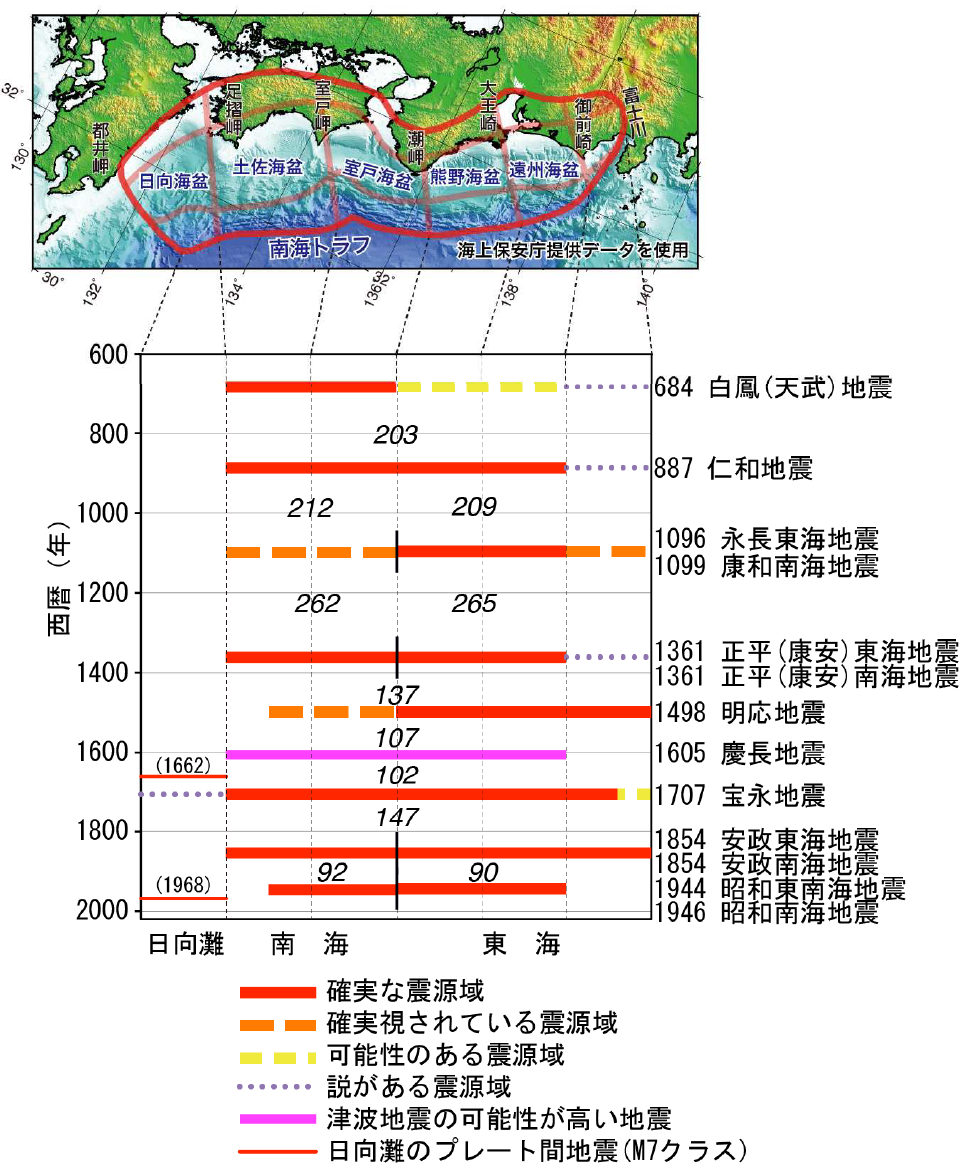
過去に発生した南海トラフ地震の震源域の時空間分布
(出典:「気象庁ホームページ」・「南海トラフの地震活動の長期評価(第二版)」(地震調査研究推進本部))
筆者は、また筆者が出張で不在にするときは家人が、毎朝、我が家のお風呂を綺麗に洗ってお湯を張る。これで、夜お風呂に入ってから朝の起床までの時間は何かに使える水が、それ以外の時間は綺麗な防災対策用水が、約200L我が家には貯まっていることになる。リスクマネジメントに関わる人間の端くれとしての心構えの一つである。
本年2023年3月、南海トラフ巨大地震をテーマにしたドラマが、4日「第1部ドラマ前編・後編」、5日「第2部 “最悪のシナリオ”にどう備えるか」と題した「NHKスペシャル」で、合計3時間以上放映された。
近い将来、確実に起こるとされる「南海トラフ巨大地震」を地震科学の面で捉えるのではなく、「身近な防災対策」の視点からフォーカスした大変見応えのある秀逸な番組であった。
大阪で町工場を経営する一家、高知で暮らす両親、東京で気象庁の地震関係部署に勤務している妹、この3つの場所の被災前、被災後の状況を人間の心模様を交えながら描いたドラマであった。「何気ない一日が地震の発生によって大きく変わっていく姿」を観ながら、自分の身に置き換えながらドラマに触れている自分にふと気づかされていた。
このドラマのなかで、「南海トラフ巨大地震」は和歌山県南方沖を震源地としてマグニチュード8.9の大地震の発生として描かれていたが、これまで色々な番組で取り上げられた南海トラフ巨大地震と少し違った取り上げ方であった。
最初の大地震で西日本が震源で日向海盆から室戸海盆まで、次の大地震は東日本が震源となり熊野海盆と遠州海盆、このように南海トラフが半分ずつ割れて大地震を発生させる「半割れ」を背景としてドラマが描かれていたからである。
政府が南海トラフ巨大地震として想定しているものは、東日本大震災と同程度の地震、マグニチュード9.0の大地震を想定しているが、多くの地震の専門家が警戒しているのは、時間差をおいて2度、M8から9を越える巨大地震が起こる、この「半割れ」と呼ばれる南海トラフ巨大地震である。
1.「南海トラフ巨大地震」に対応するキャプティブ
キャプティブという最先端の「リスクマネジメント手段」がその威力を遺憾なく発揮するリスクは、「リスクの発生頻度は低いが、一旦発生すると非常に大きな損害をもたらすリスク」であり、そのリスクの筆頭にあげられるのは「地震リスク」である。
気象庁のホームページでは、「南海トラフ地震」については、次のように記されている。
南海トラフ地震は、駿河湾から日向灘沖にかけてのプレート境界を震源域として概ね100~150年間隔で繰り返し発生してきた大規模地震です。前回の南海トラフ地震(昭和東南海地震(1944年)及び昭和南海地震(1946年))が発生してから70年以上が経過した現在では、次の南海トラフ地震発生の切迫性が高まってきています
「南海トラフ地震」は、冒頭の図にあるとおり、記録の乏しかった中世以前では200年、その後は100~150年の間隔で発生してきた。
また、「半割れ」よりも更に大きな被害を与える可能性のある、東海地震、東南海地震、南海地震が数時間から数年の期間をおいてあるいは時間を置かずに同時に3つの地震が連動していること(3連動地震)が多かったことが併せて解る。
このような、東日本大震災の何倍ものリスクに対応することは、もはや通常の地震保険では非常に困難であり、「地震保険キャプティブ」を設立すべき大きな理由がここに存在する。
2.平安時代の「南海トラフ巨大地震」の甚大な被害
地震の本格的な記録、観測、予知等の歴史は100年あまり、その土地の成り立ちや古来の地震のデータが、今後の地震予知にとって非常に重要であることは、誰しも認めることである。
平安時代の歴史書「日本三代実録」には、現在の神奈川県、東京都、埼玉県などで大地震があり、「圧死者は数え切れない」などと記載されている。869年に起きた貞観(じょうがん)地震である。この大地震の後さらに2つの大地震、878年に元慶(がんぎょう)地震、887年に仁和(にんな)地震が起きている。
「貞観地震」は、東北の太平洋沖合で起きた巨大地震であり大津波が押し寄せたことなどから、2011年の東日本大震災が、この貞観地震の再来ではないかと言われている。その9年後に起きたのが、当時の相模国、武蔵国(今の関東南部地域)に大きな被害を与えた、関東を震源とする推定マグニチュード7.4以上の「元慶地震」である。
「貞観地震」を2011年の「東日本大震災」と仮定すると、「元慶地震」の再来、「令和の関東大震災」の発生を懸念する声もある。さらに、この「元慶地震」の9年後には南海トラフを震域とする推定マグニチュード8.6と言われる巨大震災、「仁和地震」が起きたことからも、「南海トラフ大地震」が非常に懸念される。
3.その後平安時代に起きた、新たな「南海トラフ巨大地震」
「中世の巨大地震 (歴史文化ライブラリー)」矢田 俊文(著)によると1099年2月(承徳3年1月) 康和南海地震が、「南海トラフ」で起きたことが解る。
「後二条師通記」には、「奈良の興福寺、大阪の天王寺に大きな被害が出た」とあり、自然科学研究機構国立天文台編「理科年表」には「興福寺・摂津天王寺で被害、土佐で田千余町みな海に沈む津波があったらしい」と記されている。そして、この大地震の発生と同時期に発生した疫病により、承徳3年8月28日承徳は「康和」へ改元された。
冒頭記したNHKスペシャルで舞台の一つとなった高知県に関して、同書には土佐(現在の高知県)での大津波被害について次のように記されている。
土佐の被害
先に示した「理科年表」の「土佐で田千余町みな海に沈む」という記事の根拠は、何であろうか。それは次の記事である。
康和二年正月□四日地震の刻、国内の作田千余町、皆もって海底となりおわんぬ。社領□江御荘、海浜に近きに依り、またもって同前。
記事は、兼仲証紙背文書(国立歴史民俗博物館所蔵自筆本弘安六年(1283)十一月~十二月巻紙背文書)である土佐国宛の官宣旨(弁官が署名して勅命を伝えるために発布された文書)に記載されているものである。
記事に見える「社領」とは、鴨御祖社領のことである。鴨御祖社領潮江荘は、現在の高知県高知市のJR高知駅の南にある。その辺りは、中世では海浜に近い場所であった。この潮江荘をはじめとした土佐国の千余町の田地は海に沈んだと記される。
1090年(寛治4年)鴨御祖神社は「荘園」として、現在の高知市に「潮江荘」を設けたが、この地震でその田園千余町、つまり約「10㎢」が海没して、潮江荘も大きな被害を受けた。「10㎢」とは、現在の高知市の海岸沿いの地域のほとんどが地震の地殻変動によって「海没する壊滅的な被害を受けた」と記されているのである。単なる「津波被害」ではなく、「千余町の田地田地が海に沈む=大地震によって引き起こされた地盤沈下が広範な地域に及び、10㎢余りの広大な田地が海の底に没した」ということに注目しなければならない。
日本列島が位置する大陸の「ユーラシアプレート」の下に、南側から海洋プレートである「フィリピン海プレート」が接して年間数㎝の割合で沈み込んでいる場所を「南海トラフ」というが、その大変動が「南海トラフ大地震」として、100~150年間隔で繰り返し発生しているのである。
冒頭の図また下図でも解るとおり、その「南海トラフ」変動の影響を直接、そして非常に受けやすい場所に高知県が存在しているため、高知県の沿岸部には、地震によって水没した集落の伝承や、海底に沈んでいる人工物の情報が各地に残されている。なかでも有名な伝承が「黒田郡」という集落が「一夜にして海の底に沈んだ」というものである。壬申の乱に勝利して即位した天武天皇の時代、684年に発生した白鳳(天武)地震によって一夜にして海の底に沈んだ集落の伝承も各地に残っている。

(出典:「気象庁ホームページ」)
今回のまとめ
現在の地球物理学の定説では、3億年前、地球上には、「パンゲア」と呼ばれる1つの大陸が存在、それが2億年前分裂を始めたとされている。その後の分裂により、10数枚になった地球を覆う「プレート」であるが、1つのプレート内で移動速度が異なる部分があるため考え出された理論が「小規模な40数枚の小規模プレートが存在する」という考え方である。更に最近では、この小規模なプレートも細かく「ブロック分け」されていて、「その境目で大地震が発生する」ということも解ってきた。
このプレートの移動に応じて、上に乗った陸地も同じく移動している。ハワイは、1年間に約8cmずつ日本に近づいていると言われている。そして、このプレートが移動する理論「プレートテクトニクス(プレート理論)」こそが「プレート型大地震発生の有力な理論的裏付け」となっているのである。
このプレートには、「大陸側のプレート」と「海側のプレート」がある。日本を囲むプレートでは、大陸側が「ユーラシアプレート」と「北米プレート」であり、海側が「太平洋プレート」と「フィリピン海プレート」である。この4つのプレートの上に「乗っている」のが日本である。移動する「プレート」が4つもある世界でも希な場所が日本列島である、だから地震が頻発する。
海洋プレートは、大陸プレートよりも強固で密度が高いため、2つのプレートが衝突すると海洋プレートは大陸プレートの下に沈んでいく。太平洋プレートが北米プレートの下に沈み込んでいく際に発生した地震が「東日本大震災」であり、フィリピン海プレートがユーラシアプレートの下に沈み込んでいる接地面を「南海トラフ」と言い、その沈み込みの際に発生する現象が、発生が強く懸念されている「南海トラフ巨大地震」である。
「温故知新」とは言い古された言葉であるが、「満足な予知ができない事象」に対してはこれほど重要な言葉はない。古来起きた事象を知り、今後起こる可能性のあることを予測してその事態に備える。過去にどんな地震があり、どんな損害が発生したか、これを識ることは重要な「将来への備え」になる。
損害保険の世界では、「事故などで対象物が物理的影響を被ること」を「損害」といい、「損害を被った結果、その対象と一定の関係がある人に与える経済的影響のこと」を「損失」というが、「地震リスク」という「損失を被る可能性」である不確定な要素を保険料というコストとして確定させる仕組みである「地震保険」を活用することによって「企業経営の不確実性」を減じていくことは、重要な経営戦略である。
しかし、「地震保険」を利用したとしても、単なる地震による建物等の損壊というリスクだけではなく、「平安時代に高知で起きた大規模な地殻変動が起き陸地が海底する」ことにも対応できる地震保険でなければその意味を成さない。一般的に手に入る地震保険は単なる物的損害のみを補償する地震保険である。そのために必要なものが欧米では一般的なリスクマネジメント策と言われて、ほとんどの大企業、団体では「当り前に設立されている仕組み」がキャプティブである。
東日本大震災のとき飛び交った「想定外」という言葉を発しないためにも、「キャプティブ」という仕組みを上手く活用して、通常得られる地震保険を「補償金額、補償内容、補償範囲の面から充実させていくこと」、また地震保険を単なるコストにせず「リスクを収益にさえ変えていくこと」、これらもまた重要な経営戦略になるのではないだろうか。
キャプティブに眼を注がない企業は、コーポレート・ガバナンスを放棄した企業、団体と言われ、欧米では当然のごとく役員の責任が厳しく追及される。
地震大国と言われながら、米国の企業が有するキャプティブは5000社、一方日本企業が有するキャプティブは100社足らずという現状がなぜあるのであろうか。国難とも言われている南海トラフ巨大地震、その発生に対応しない企業、団体の役員は、また「想定外」という言葉を発するのだろうか。その時は「もはやすべてが手遅れ」となっている。
「半割れ」が起きた場合、南海トラフ巨大地震は東日本大震災が二つ起きるエネルギーを発する超巨大地震と想定されているからである。「一刻も早い、全国ベースでの地震保険キャプティブの設立が必要だ」と緊急地震速報が流れる度に思っている。
執筆・翻訳者:羽谷 信一郎
English Translation
Risk Management (RM) 78 – Nankai Trough giant earthquake is equivalent to two Great East Japan Earthquakes
Every morning, and when the author is away on business, the family washes our bathroom clean and fills it with hot water. This means that from the time we take a bath at night until we get up in the morning, we have water that can be used for something, and the rest of the time we have about 200 litres of clean water stored in our home for disaster preparedness. It is one of the ways in which I am prepared to be on the fringe of those involved in risk management.
In March 2023, a drama on the theme of a huge Nankai Trough earthquake was broadcast for a total of more than three hours on the 4th (Part 1: Drama First and Second) and on the 5th (Part 2: How to prepare for the” worst-case scenario”) in an NHK Special.
It was an excellent and highly worthwhile programme that focused on the Nankai Trough giant earthquake, which is certain to occur in the near future, not from the perspective of earthquake science, but from the perspective of “disaster-prevention measures in our daily lives”.
The drama depicted the situation of a family, who run a factory in Osaka, their parents living in Kochi and their younger sister working in the earthquake department of the Japan Meteorological Agency in Tokyo, before and after the disaster, while also showing the human emotions of these three places. As I watched the drama, I was suddenly aware that I was watching it from my own experience, as an ordinary day was drastically changed by the earthquake.
In the drama, the Nankai Trough Earthquake was depicted as a major earthquake of magnitude 8.9 with its epicentre off the southern coast of Wakayama Prefecture, but the way it was depicted was slightly different from the Nankai Trough Earthquakes that have been featured in various programmes.
The first major earthquake had its epicentre in western Japan, from the Hyuga Basin to the Muroto Basin, while the next one had its epicentre in eastern Japan, in the Kumano Basin and the Enshu Basin, thus depicting the Nankai Trough as a half-split, which causes a major earthquake when the trough is split in half.
The government’s assumption of a huge Nankai Trough earthquake is a magnitude 9.0 earthquake, the same magnitude as the Great East Japan Earthquake, but many earthquake experts are on the lookout for this “half-crack” Nankai Trough megathrust earthquake, which will be followed by two massive earthquakes of M8 to M9 magnitude or greater, separated by a time gap.
1. Captives for the “Nankai Trough Earthquake”.
Risks for which the state-of-the-art risk management tools of captives can demonstrate their full potential are “risks that occur infrequently but, once they do occur, can cause very large damage”. The first of these risks is the risk of earthquakes.
The JMA website describes a “Nankai Trough Earthquake” as follows.
Nankai Trough earthquakes are large-scale earthquakes that have repeatedly occurred at intervals of approximately 100 to 150 years, with their epicentre located at the plate boundary between Suruga Bay and off the coast of Hyuga Sea. More than 70 years have passed since the last Nankai Trough earthquakes (Showa Tonankai Earthquake (1944) and Showa Nankai Earthquake (1946)) occurred, and the imminence of the next Nankai Trough earthquake is increasing.
“Nankai Trough earthquakes”, as shown in the diagram at the beginning of this issue, occurred at intervals of 200 years before the Middle Ages, when records were scarce, and at intervals of 100 to 150 years afterwards.
It can also be seen that Tokai, Tonankai and Nankai earthquakes, which have the potential to cause even greater damage than a “half-crack”, often occurred within a period of a few hours to a few years, or that three earthquakes were linked together at the same time without a time interval (triple-linked earthquake). It is extremely difficult for ordinary earthquake insurance to cope with risks many times greater than those of the Great East Japan Earthquake, and this is a major reason why an “earthquake insurance captive” should be established.
2. the enormous damage caused by the “Nankai Trough Earthquake” in the Heian Period.
The history of full-scale recording, observation and prediction of earthquakes is only about 100 years old, and everyone agrees that data on the origins of the land and ancient earthquakes are extremely important for the prediction of future earthquakes.
In the Heian-period history book Nihon sandai jitsuroku, it is stated that there were major earthquakes in present-day Kanagawa, Tokyo, Saitama and other prefectures, and that “the number of people crushed to death was countless”. This was followed by two more major earthquakes, the Gangyou earthquake in 878 and the Ninna earthquake in 887.
The Jogan earthquake was a massive earthquake that occurred off the Pacific coast of the Tohoku region and caused a massive tsunami, leading some to speculate that the Great East Japan Earthquake of 2011 may be a reoccurrence of the Jogan earthquake. Nine years later, the Genkei Earthquake, with an estimated magnitude of over 7.4 on the Richter scale, struck the Kanto region, causing extensive damage in the then Sagami and Musashi provinces (now the southern part of the Kanto region).
Assuming that the Jogan Earthquake was the Great East Japan Earthquake of 2011, some fear a return of the Genkei Earthquake and the Great Kanto Earthquake of 2022. Furthermore, there is great concern about a major Nankai Trough earthquake, given that nine years after the Genkei Earthquake, the Ninna Earthquake, a massive earthquake with an estimated magnitude of 8.6 on the Richter scale, occurred in the Nankai Trough.
3. a new “Nankai Trough earthquake” in the Heian period (794-1185).
According to the book “Giant Earthquakes in the Middle Ages (Rekishi Bunka Library)” by Toshifumi Yada, the February 1099 (January 3, Shotoku 3) Kowa Nankai Earthquake occurred in the Nankai Trough.
The Go Nijo Shih-tsuki states that “Kofuku-ji Temple in Nara and Tenno-ji Temple in Osaka were severely damaged”, while the National Astronomical Observatory of Japan, National Institutes of Natural Sciences, states that “Kofuku-ji Temple and Settsu Tenno-ji Temple were damaged and in Tosa there was a tsunami that submerged more than a thousand towns of rice fields in the sea”. Due to an epidemic that occurred at the same time as the earthquake, the name of Shōtoku was changed to Kōwa on 28 August in the 3rd year of Shōtoku.
In relation to Kochi Prefecture, which was one of the settings for the NHK special mentioned at the beginning of this article, the book describes the damage caused by the tsunami in Tosa (present-day Kochi Prefecture) as follows.
Damage in Tosa
What is the basis for the article in the Rika Nenpyo, “All of Tosa’s 1,000 paddies and towns sink into the sea”, as indicated above? It is the following article.
At the time of the earthquake on the 4th day of the 4th month of the 2nd year of the 1st year of the Kouwa Era, all the rice paddies in the country, more than 1,000 towns, were submerged under the sea. The company’s domain, Sukue Goso, is close to the seashore, and therefore also in front of the same.
The article is from a kanenaka shoshi-hai document (a document signed by the benga and issued to convey imperial orders) addressed to the Tosa Province, which is an autograph copy of a kanenaka shoshi-hai document (an autograph copy of a shoshi-hai document in the collection of the National Museum of Japanese History, November – December, 1283).
The “shrine domain” visible in the article refers to the Kamo-miso-sha domain. The Kamo-miso-sha-ryo Ushioe-so is located south of JR Kochi Station in present-day Kochi City, Kochi Prefecture. The area was close to a seaside beach in the Middle Ages. It is recorded that this Ushioe-so and more than 1,000 other towns in Tosa Province were submerged in the sea.
In 1090, the Kamo-miso-sha established Ushioe-so in present-day Kochi City as a “manor”, but the earthquake submerged a thousand paddies and towns of its fields, or about “10㎢”, and Ushioe-so was also severely damaged. The “10㎢” means that most of the area along the coast of present-day Kochi was “devastated by the submergence of the sea” due to the tectonic movements of the earthquake. It should be noted that this is not mere “tsunami damage”, but that “more than a thousand rice fields and rice paddies sank into the sea = the subsidence caused by the great earthquake covered a wide area and submerged a vast area of rice paddies of more than 10㎢ into the seabed”.
The Nankai Trough is the area where the Philippine Sea Plate, an oceanic plate, is subducting at a rate of several centimetres per year under the Eurasian Plate, the continental plate on which the Japanese islands are located, and the Nankai Trough is the place where the plate is touching from the south. The Nankai Trough is a place where the subduction of several cm of land is present at the same time.
As can be seen in the diagram above, Kochi Prefecture is located in a place that is directly and extremely vulnerable to the effects of the Nankai Trough, so there are legends of settlements submerged by earthquakes and information on artifacts that have sunk to the sea floor in the coastal areas of Kochi Prefecture in many places. One of the most famous traditions is that the settlement of Kuroda-gun “sank to the bottom of the sea overnight”. Traditions of settlements that sank to the bottom of the sea overnight as a result of the Hakuho (Temmu) Earthquake of 684 during the reign of Emperor Temmu, who ascended to the throne after winning the Jinshin War, remain in many places.
Summary of this issue
According to current geophysical theory, 300 million years ago, there was one continent on the Earth, called Pangaea, which began to break up 200 million years ago. The theory that was devised to explain the existence of more than 40 small plates, which move at different speeds within a plate, is based on the idea that there are more than 10 plates covering the Earth. More recently, it has become clear that these small plates are also finely divided into blocks, and that major earthquakes occur at the boundaries between them.
As these plates move, the land on top of them moves as well. Hawaii is said to be moving closer to Japan by about 8 cm per year. The theory of plate tectonics (plate theory), the theory of plate movement, is a ‘strong theoretical support for the occurrence of large plate earthquakes’.
There are two types of plate: continental plates and oceanic plates. The plates surrounding Japan are the Eurasian Plate and the North American Plate on the continental side, and the Pacific Plate and the Philippine Sea Plate on the ocean side. Japan “rides” on these four plates. The Japanese islands are one of the few places in the world where there are four moving plates, which is why earthquakes occur so frequently.
Oceanic plates are stronger and denser than continental plates, so when the two plates collide, the oceanic plates sink beneath the continental plates. The earthquake that occurred when the Pacific Plate subducted under the North American Plate was the Great East Japan Earthquake, while the Philippine Sea Plate is subducting under the Eurasian Plate and its contact surface is called the Nankai Trough, and the phenomenon that occurs during subduction is the highly feared Nankai Trough Giant The phenomenon that occurs when the ground sinks is called the Nankai Trough, and is the subject of strong concern.
The term “new knowledge of the past” is an old saying, but there is no more important word for events that cannot be satisfactorily foreseen. Knowing what has happened in the past and predicting what is likely to happen in the future, we must prepare for such events. Knowing what earthquakes have occurred in the past and what kind of damage they have caused is an important ‘preparation for the future’.
In the world of non-life insurance, “damage” refers to the physical impact of an object due to an accident, etc., and “loss” refers to the economic impact on people who have a certain relationship with the object as a result of the damage. It is an important management strategy to reduce “uncertainty in corporate management” by utilising “earthquake insurance”, which is a mechanism to determine the “possibility of suffering losses” as a cost in the form of insurance premiums.
However, the use of earthquake insurance is meaningless unless it covers not only the risk of buildings being damaged by earthquakes, but also the risk of land being undermined by large-scale crustal movements that occurred in Kochi in the Heian Period. The earthquake insurance policies that are generally available are merely earthquake insurance policies that cover only physical damage. What is needed for this is a captive system, which is considered a common risk management measure in Europe and the US, and is established as a matter of course by most large companies and organisations.
In order to achieve this, and in order to avoid the term “unexpected” that flew around at the time of the Great East Japan Earthquake, it is necessary to make good use of the captive mechanism, to “enhance the normally available earthquake insurance in terms of coverage amount, coverage content and coverage”, and to “turn risk into profit” rather than making earthquake insurance a mere cost. These are also important management strategies.
Companies that do not focus on captives are said to be companies or organisations that have abandoned corporate governance, and in Europe and the US, directors and officers are rightly held accountable.
Is it the fact that, despite being called an earthquake-prone country, the number of captives held by US companies is 5,000, while Japanese companies have less than 100? Will the executives of companies and organisations that do not respond to the Nankai Trough earthquake, which is said to be a national disaster, again utter the words ‘unforeseen’? By then, it will be “too late for everything”.
This is because, in the event of a “half-crack”, a giant Nankai Trough earthquake is assumed to be a super-mega earthquake emitting energy that could cause two Great East Japan Earthquakes.”We need to establish an earthquake insurance captive on a national basis as soon as possible,” I think every time an earthquake early warning is issued.
Author/translator: Shinichiro Hatani