
キャプティブ 2024.08.26
CA 63 2024年8月8日「南海トラフ地震臨時情報」発表
目次
- 1.「東日本大震災」の2日前に発表された「2011年2月の月例報告書」
- 2.2024年4月17日、豊後水道で発生したM6.6の地震
- 3.2024年8月8日「南海トラフ地震臨時情報(巨大地震注意)」発表
- 4.2024年8月22日気象庁の発表
- 今回のまとめ
- 1. the ‘February 2011 Monthly Report’ published two days before the ‘Great East Japan Earthquake’.
- 2. The M6.6 earthquake that occurred in the Bungo Channel on 17 April 2024
- 3. On 8 August 2024, the ‘Nankai Trough Earthquake Special Information (Warning of a Major Earthquake)’ was announced.
- 4. 22 August 2024 Japan Meteorological Agency Announcement
- Summary of this Issue
Copyright © Shinichiro Hatani 2024 All rights reserved
For those who prefer to read this column in English, the Japanese text is followed by a British English translation, so please scroll down to the bottom of the Japanese text.
今から13年前、2011年、政府の「地震調査研究本部 地震調査委員会」が2月の「月例報告」を発表したのは、翌月の3月9日であった。その「2.各地方別の地震活動 (2)東北地方」の箇所には、以下のように記されている。
○ 2月10日に福島県沖の深さ約50kmでマグニチュード(M)5.4の地震が発生した。この地震の発震機構は西北西-東南東方向に圧力軸を持つ逆断層型で、太平洋プレートと陸のプレートの境界で発生した地震である。
○2月27日に福島県沖の深さ約45km で M5.2の地震が発生した。この地震の発 震機構は西北西-東南東方向に圧力軸を持つ逆断層型で、太平洋プレートと陸の プレートの境界で発生した地震である。
更に、「2011年2月の地震活動の評価についての補足説明」のページには、「2.各地方別の地震活動」の「(2)東北地方」として、次のように記されている。
三陸沖で2月 13 日から M5.0 以上の地震が4回発生するなどのまとまった地震活動があった。最大の地震は、16日に発生した M5.5であった。発震機構はいずれも西北西-東南東方向に圧力軸を持つ逆断層型で、太平洋プレートと陸のプレートの境界で発生した地震である。

1.「東日本大震災」の2日前に発表された「2011年2月の月例報告書」
この「2011年2月の月例報告書」のどこにも、「大震災の発生」を予見するような言葉は記述されていない。そして、この発表の2日後、3月11日、三陸沖で、日本の観測史上最大と言われるM9.0の東日本大震災が発生した。
死者・行方不明者2万人以上という、史上稀に見る巨大地震であった。最大震度は、震度階級の最高である「7」を観測、北海道地方、東北地方、関東地方の太平洋沿岸すべてで、大津波を観測、東京湾をはじめ多くの場所で液状化が発生するなど甚大な被害を生じさせたが、その2日前ですら日本の英知を集めた地震の専門家達でも全く予見できなかったのである。
この時、マスコミを賑わしたのは「想定外」という言葉であった。一躍「時の言葉」となったこの言葉を多くの人々は憶えていることだろう。
2.2024年4月17日、豊後水道で発生したM6.6の地震
南海トラフ地震の想定震源域は、3つに分かれている。静岡地方を想定震源域とする「東海地震」、愛知、三重、和歌山を想定する「東南海地震」、その以西、宮崎沖まで伸びる想定震源域を持つ「南海地震」である。時間差があっても、これら3つの震源域が連動する可能性が高いと言われ「東日本大震災を遙かに凌ぐ、超巨大震災になる」と予測されている地震である。
日本列島の真ん中にある大地溝帯、「フォッサマグナ」を境にして、西半分は「ユーラシアプレート」、東半分は「北米プレート」とその「土台」が別れている。この「日本列島の背骨」とも言われる、長さ1,000kmに及ぶ長大な大断層帯「中央構造線」は、茨城から関東を通り、諏訪を経て、三重、和歌山、さらに四国を縦断して大分に入り、九州の八代、熊本を経て太平洋へ抜ける長大な大断層帯である。九州、大分県から熊本県に至る一帯を走る中央構造線上には、別府温泉をはじめ湯布院と有名な温泉地が連なっていて、この温泉地熱現象によって、新しい火山活動や地震が活発な地域である。
1596年には、「島を水没させた」と伝承が残る、マグニチュード7.0の「慶長豊後地震」が起きた一帯が豊後水道である。4月17日のM6.6の地震はこの場所で起きたのである。
3.2024年8月8日「南海トラフ地震臨時情報(巨大地震注意)」発表
その約4ヶ月後、8月8日、日向灘を震源とするマグニチュード7.1の地震が発生した。このことを受けて、気象庁は初の「南海トラフ地震臨時情報(巨大地震注意)」を発表した。
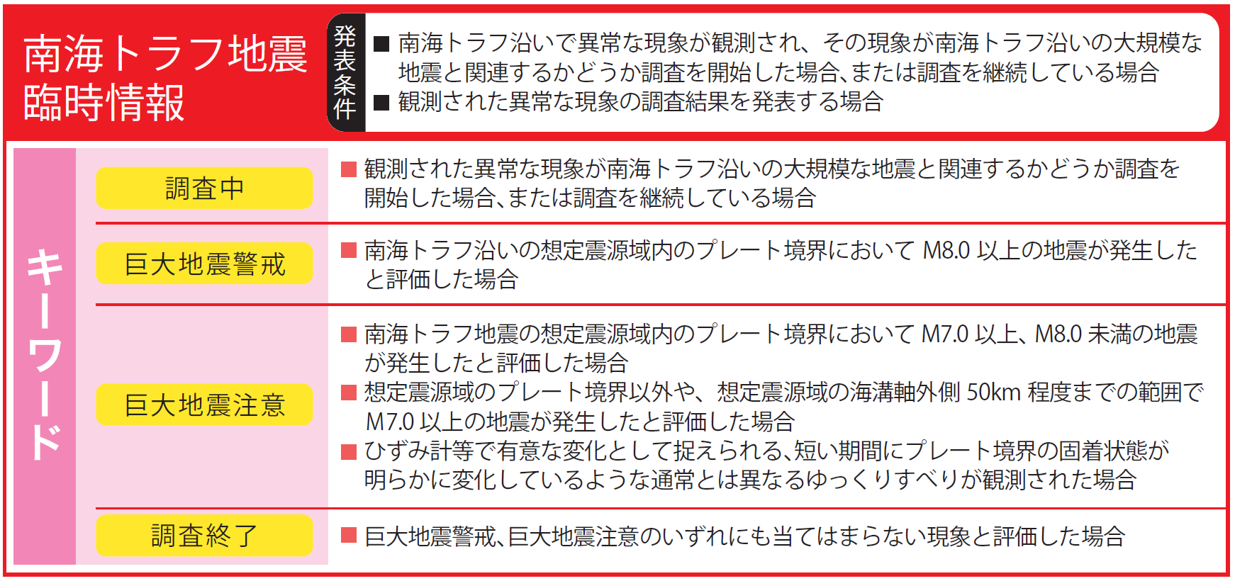
内閣府の公式WEBサイトの「防災情報のページ」には、以下のように「南海トラフ地震臨時情報とは?」という記述がある。
3.南海トラフ地震臨時情報とは?
「南海トラフ地震臨時情報」は、南海トラフ沿いで異常な現象を観測された場合や地震発生の可能性が相対的に高まっていると評価された場合等に、気象庁から発表される情報です。情報名の後にキーワードが付記され「南海トラフ地震臨時情報(調査中)」等の形で情報発表されます。
気象庁において、マグニチュード6.8以上の地震等の異常な現象を観測した後、5~30分後に南海トラフ地震臨時情報(調査中)が発表されます。その後、「南海トラフ沿いの地震に関する評価検討会」の臨時会合における調査結果を受けて、該当するキーワードを付した臨時情報が発表されます。
政府や自治体から、キーワードに応じた防災対応が呼びかけられますので、呼びかけの内容に応じた防災対応をとってください。
4.2024年8月22日気象庁の発表
気象庁は、「南海トラフ地震臨時情報(巨大地震注意)」発表の2週間後、8月22日、以下のように発表した。
令和6年8月22日15時30分
気象庁南海トラフ地震関連解説情報(第8号)
** 見出し **
8月8日16時43分頃に日向灘を震源とするマグニチュード7.1の地震が発生しました。この地震の発生後、南海トラフ地震の想定震源域ではプレート境界の固着状況に特段の変化を示すような地震活動や地殻変動は観測されていません。南海トラフ沿いでは、いつ大規模地震が発生してもおかしくないことに留意し、「日頃からの地震への備え」を引き続き実施してください。** 本文 **
8月8日16時43分頃に日向灘を震源とするマグニチュード7.1(モーメントマグニチュード7.0)の地震が発生しました。この地震の発生に伴って、南海トラフ地震の想定震源域では、大規模地震の発生可能性が平常時に比べて相対的に高まっていると考えられたことから、8月8日19時15分に南海トラフ地震臨時情報(巨大地震注意)を発表しました。この地震の震源付近の地震活動は、当初は活発でしたが、時間の経過とともに低下しています。しかし、日向灘では過去に、最初の地震の1ヶ月半後にそれと同程度の規模の地震が発生したこともあります。
8月8日16時から本日(8月22日)12時までに南海トラフ地震の想定震源域(8月8日の地震の震源域周辺を含む)で発生した震度1以上を観測した地震の回数(速報値)は次の通りです。
8月 8日16時から8月15日24時まで 24回(震度6弱:1回、震度3:2回、震度2:5回、震度1:16回)
8月16日00時から8月22日12時まで 0回また、ひずみ観測点では、マグニチュード7.1の地震に伴うステップ状の変化が観測されていますが、地震後に通常みられる変化以外は今のところ観測されていません。東海から紀伊半島及び四国の深部低周波地震(微動)活動に伴う変化が付近のひずみ計等で観測されていますが、従来からも繰り返し観測されてきた現象です。8月8日21時頃から、日向灘及び九州地方南東沖で浅部超低周波地震を観測しています。この現象は従来からも繰り返し観測されてきた現象ですが、発生頻度・規模等発生様式については今後も観測・研究が必要です。また、8月8日の地震発生後、宮崎県南部を中心に、地震後の余効変動と考えられる地殻変動を観測しています。余効変動自体はM7クラス以上の地震が発生すると観測されるものですが、今回の余効変動は、そのような地震後に観測される通常の余効変動の範囲内と考えられます。なお、地震直後に余効変動のメカニズムを見極めることは困難であり、ある程度の期間、観測を続ける必要があります。
そのほか、8月5日頃から、紀伊半島沖で地殻変動に起因するとみられる孔内間隙水圧の変化を観測しています。この現象は従来からも繰り返し観測されてきた現象です。このように、8月8日の地震の発生後、南海トラフ地震の想定震源域ではプレート境界の固着状況に特段の変化を示すような地震活動や地殻変動は観測されていません。
政府では、8月8日16時43分頃の日向灘を震源とする地震の発生から1週間経過したことから、8月15日17時をもって、南海トラフ地震臨時情報(巨大地震注意)発表に伴う政府としての「特別な注意の呼びかけ」を終了しています。
過去の世界的な事例をみると、大規模地震の発生の可能性は、最初の地震(8月8日の地震)の発生直後ほど高く、時間の経過とともにその可能性が低下していく傾向がありますが、最初の地震から1週間以上経過した後に大規模地震が発生した事例もあります。
南海トラフ沿いの大規模地震(マグニチュード8から9クラス)は、「平常時」においても今後30年以内に発生する確率が70から80%であり、昭和東南海地震・昭和南海地震の発生から約80年が経過していることから切迫性の高い状態です。
南海トラフ沿いで異常な現象が観測されず、突発的に南海トラフ地震が発生することもあります。
南海トラフ沿いでは、いつ大規模地震が発生してもおかしくないことに留意し、「日頃からの地震への備え」については、引き続き実施してください。気象庁では、引き続き注意深く南海トラフ沿いの地殻活動の推移を監視します。
※モーメントマグニチュードは、震源断層のずれの規模を精査して得られるマグニチュードです。気象庁が地震情報等で、お知らせしているマグニチュードとは異なる値になる場合があります。
今回のまとめ
弊社ホームページの「代表メッセージ」に「2011年3月11日の東日本大震災発生時、補償が及ばないリスクによる損害のため、企業が支払う保険料に対して日本の保険会社から支払われる保険金があまりにも少ないという日本の損害保険制度の限界を思い知らされました。」と記したとおり、2011年3月11日(金)午後2時46分に発生した東日本大震災の状況映像がテレビによって繰り返し映される、津波によって流される何千台もの自動車を見て、損害保険の限界を強く感じ、それが後に「キャプティブ事業」へ自らを駆り立てるきっかけとなったことを強く憶えている。
8月22日、南海トラフ地震臨時情報の上記「終了発表」では、「政府では、8月8日16時43分頃の日向灘を震源とする地震の発生から1週間経過したことから、8月15日17時をもって、南海トラフ地震臨時情報(巨大地震注意)発表に伴う政府としての「特別な注意の呼びかけ」を終了しています。」とある。
しかし、その後には、上記のとおり、以下の言葉が続いている
過去の世界的な事例をみると、大規模地震の発生の可能性は、最初の地震(8月8日の地震)の発生直後ほど高く、時間の経過とともにその可能性が低下していく傾向がありますが、最初の地震から1週間以上経過した後に大規模地震が発生した事例もあります。
南海トラフ沿いの大規模地震(マグニチュード8から9クラス)は、「平常時」においても今後30年以内に発生する確率が70から80%であり、昭和東南海地震・昭和南海地震の発生から約80年が経過していることから切迫性の高い状態です。
南海トラフ沿いで異常な現象が観測されず、突発的に南海トラフ地震が発生することもあります。
南海トラフ沿いでは、いつ大規模地震が発生してもおかしくないことに留意し、「日頃からの地震への備え」については、引き続き実施してください。
気象庁では、引き続き注意深く南海トラフ沿いの地殻活動の推移を監視します。
気象庁、地震調査研究本部、関係者の方々の「注意喚起は(決まったことなので)止めますが、地震発生の状況は変っていません」という思い、その判断に至るまでの苦悩が現われていると筆者は感じた文章であった。
観測史上最大の地震、東日本大震災の2日前でもその予兆を測定することができなかった。その後、政府は「南海トラフ海底地震津波観測網(N-net)の構築」等、鋭意、南海トラフ地震の観測・予知に努めてきてはいるが、地球規模のプレート、それも何枚もの巨大なプレートが引き起こす大地震、その予知、予測が簡単にできるかどうかは、少し地震に関係することを学べば分かることである。
しかし、国民は日本の叡智に多くを期待している。ただ、言えることは、南海トラフ地震が発生した場合、その損害は東日本大震災の比ではないということ、日本の国家予算を遙かに上回る規模であり、東日本大震災の何十倍もの損害になる可能性が高いということである。
政府、地方公共団体の努力だけではあがなうことができない事態であり、国民、特に多くの資金を有し、大きな資産を抱えている企業の努力が求められるところではないだろうか。
筆者が、企業へ「キャプティブを活用した補償プログラムの構築」を本コラムで強くお勧めしている理由でここにある。「起きてからでは遅い」からである。
執筆・翻訳者:羽谷 信一郎
English Translation
CA 63 ー 8 August 2024 ‘Temporary Information on the Nankai Trough Earthquake’ announced on 8 August 2024
Thirteen years ago, in 2011, the government’s Earthquake Research Institute Headquarters, Earthquake Research Committee, released its Monthly Report for February on 9 March the following month. In its ‘2. Seismic Activity by Region (2) Tohoku Region’ section, it stated the following.
On 10 February, a magnitude (M) 5.4 earthquake occurred at a depth of approximately 50 km off the coast of Fukushima Prefecture. The seismic mechanism of this earthquake was a reverse fault type with a pressure axis in the west-northwest-east-southeast direction, and the earthquake occurred at the boundary between the Pacific Plate and the land plate.
On 27 February, an earthquake of M5.2 occurred off the coast of Fukushima Prefecture at a depth of about 45 km. The earthquake was of a reverse fault type with a pressure axis in the west-northwest-east-southeast direction and occurred at the boundary between the Pacific Plate and the land plate.
Furthermore, on the page ‘Supplementary Explanation of the Assessment of Seismic Activity in February 2011’, the following is described as ‘(2) Tohoku Region’ in ‘2.
There was a coherent seismic activity, with four earthquakes of M5.0 or greater occurring off the coast of Sanriku from 13 February. The largest earthquake was an M5.5 on 16 February. All of the earthquakes were of reverse fault type with a pressure axis in the west-northwest-east-southeast direction and occurred at the boundary between the Pacific Plate and the land plate.
1. the ‘February 2011 Monthly Report’ published two days before the ‘Great East Japan Earthquake’.
Nowhere in this ‘February 2011 Monthly Report’ is the word ‘giant earthquake’ predicted. However, two days after this announcement, on 11 March, the Great East Japan Earthquake of 9.0 magnitude, said to be the largest ever recorded in Japan, occurred off the coast of Sanriku. More than 20 000 people were killed or missing, making it one of the most massive earthquakes in history.
The maximum intensity of the earthquake was 7, the highest on the seismic scale, and massive tsunamis were observed along the Pacific coast of Hokkaido, Tohoku and Kanto regions. The earthquake was not foreseen even two days earlier by Japan’s most knowledgeable earthquake experts.
At the time, the word ‘unexpected’ was all over the media. Many people will remember that it became the ‘word of the hour’.
2. The M6.6 earthquake that occurred in the Bungo Channel on 17 April 2024
The expected epicentres of the Nankai Trough earthquake are divided into three areas. There is the Tokai earthquake, which has its expected epicentre in the Shizuoka region, the Tonankai earthquake, which has its expected epicentre in Aichi, Mie and Wakayama, and the Nankai earthquake, which has its expected epicentre stretching west to Miyazaki. Even if there is a time difference, it is said that there is a high possibility that these three source regions will be linked, and it is predicted that it will be a super-giant earthquake that far surpasses the Great East Japan Earthquake.
The western half of the Japanese archipelago is on the Eurasian Plate, and the eastern half is on the North American Plate, with the ‘fossa magna’ (a large rift valley) in the middle of the Japanese archipelago acting as a boundary between them. This long, 1,000km-long fault line, known as the backbone of the Japanese archipelago, runs from Ibaraki through Kanto, then through Suwa, Mie, Wakayama and Shikoku, before entering Oita and continuing on to Yatsushiro and Kumamoto in Kyushu, where it finally reaches the Pacific Ocean. The Chuo Tectonic Line runs through the area from Oita to Kumamoto Prefecture in Kyushu, and is home to a series of famous hot spring resorts, including Beppu Onsen and Yufuin Onsen. This hot spring area is also an area where new volcanic activity and earthquakes are particularly active.
The area where the 1596 Keicho Bungo Earthquake, which is said to have caused the sinking of an island, occurred was the Bungo Channel. The 17 April earthquake of magnitude 6.6 occurred in this area.
On 8 August, an earthquake of magnitude 7.1 occurred with its epicentre in Hyuganada. In response to this, the Japan Meteorological Agency issued its first ‘Nankai Trough Earthquake Special Information (Warning of a Major Earthquake)’.
On the Cabinet Office’s official website, the ‘Disaster Prevention Information’ page includes the following description of ‘What is the Nankai Trough Earthquake Temporary Information?
3. On 8 August 2024, the ‘Nankai Trough Earthquake Special Information (Warning of a Major Earthquake)’ was announced.
3. What is the Nankai Trough Earthquake Temporary Information?
‘Nankai Trough Earthquake Temporary Information’ is information released by the Japan Meteorological Agency when an abnormal phenomenon is observed along the Nankai Trough or when the possibility of an earthquake occurring is assessed as having increased. The information is released with a keyword added after the name of the information, in the form of “Nankai Trough Earthquake Temporary Information (under investigation)”, etc.After the Japan Meteorological Agency observes an abnormal phenomenon such as an earthquake of magnitude 6.8 or greater, a Nankai Trough Earthquake Temporary Information (under investigation) is announced 5 to 30 minutes later. After that, a temporary information with the relevant keyword is announced based on the results of the investigation at the extraordinary meeting of the ‘Nankai Trough Earthquake Evaluation Study Group’.
The government and local governments will call for disaster prevention measures in response to the keywords, so please take disaster prevention measures in accordance with the content of the call.
4. 22 August 2024 Japan Meteorological Agency Announcement
Two weeks after the release of the ‘Nankai Trough Earthquake Special Information (Warning of a Major Earthquake)’, the Japan Meteorological Agency made the following announcement on 22 August.
22 August 2024 at 15:30
Japan Meteorological Agency
Nankai Trough Earthquake Related Commentary Information (No. 8)
** HEADING **
At 16:43 on 8 August, an earthquake of magnitude 7.1 occurred with its epicentre in Hyuganada. Following this earthquake, no earthquake activity or crustal deformation has been observed in the assumed epicentral region of the Nankai Trough Earthquake that would indicate any particular change in the state of fixation of the plate boundaries. Please continue to take ‘everyday earthquake precautions’ with the understanding that a large-scale earthquake could occur at any time along the Nankai Trough.
** Main text **
At around 16:43 on 8 August, an earthquake of magnitude 7.1 (moment magnitude 7.0) occurred with its epicentre in Hyuganada. Following this earthquake, the possibility of a large-scale earthquake occurring in the Nankai Trough Earthquake Hypocentral Region was considered to be relatively higher than usual, so at 19:15 on 8 August, we issued a Nankai Trough Earthquake Temporary Information (Warning of a Large Earthquake).
Earthquake activity in the area around the hypocentre of this earthquake was initially high, but has since decreased with the passage of time. However, in the Hyuganada area, there have been cases in the past where an earthquake of a similar scale to the first earthquake occurred a month and a half later.
The following is a preliminary count of the number of earthquakes of intensity 1 or greater that occurred in the assumed epicentral area of the Nankai Trough Earthquake (including the area around the epicentre of the 8 August earthquake) between 16:00 on 8 August and 12:00 today (22 August).
From 16:00 on 8 August to 24:00 on 15 August: 24 times (Intensity 6-lower: 1 time, Intensity 3: 2 times, Intensity 2: 5 times, Intensity 1: 16 times)
From 00:00 on 16 August to 12:00 on 22 August: 0 times
In addition, at the strain observation points, step-like changes associated with the magnitude 7.1 earthquake have been observed, but so far no changes other than those normally seen after an earthquake have been observed. Changes associated with deep low-frequency earthquake (microtremor) activity in the Tokai to Kii Peninsula and Shikoku regions have been observed using nearby strainmeters, etc., but this is a phenomenon that has been observed repeatedly in the past.
Since around 21:00 on 8 August, shallow very low-frequency earthquakes have been observed in the Hyuganada and southeast off the Kyushu region. This phenomenon has been observed repeatedly in the past, but the frequency, scale, and other characteristics of the occurrence will need to be observed and studied in the future. In addition, after the earthquake on 8 August, crustal deformation thought to be post-earthquake residual deformation has been observed, mainly in southern Miyazaki Prefecture.
After an earthquake of magnitude 7 or greater, post-seismic deformation is observed, but the post-seismic deformation observed this time is thought to be within the normal range of post-seismic deformation observed after such earthquakes. It is difficult to determine the mechanism of post-seismic deformation immediately after an earthquake, so it is necessary to continue observations for a certain period of time.
In addition, since around 5 August, we have been observing changes in pore water pressure in boreholes, which are thought to be caused by crustal deformation off the Kii Peninsula. This phenomenon has been observed repeatedly in the past.
As you can see, since the earthquake on 8th August, there has been no seismic activity or crustal deformation in the assumed source region of the Nankai Trough earthquake that would indicate any particular change in the state of plate boundary locking.
As a week has passed since the earthquake with its epicentre in the Hyuganada Sea occurred at around 16:43 on 8 August, the government has ended its ‘call for special caution’ in conjunction with the announcement of the Nankai Trough Earthquake Special Information (Warning of a Major Earthquake) as of 17:00 on 15 August.
Looking at past global examples, the possibility of a large-scale earthquake occurring is highest immediately after the first earthquake (the earthquake on 8 August), and the likelihood of this decreases over time, but there are also cases where a large-scale earthquake has occurred more than a week after the first earthquake.
The probability of a large-scale earthquake (magnitude 8 to 9) occurring along the Nankai Trough within the next 30 years is 70 to 80%, even in ‘normal times.
Since about 80 years have passed since the Showa Tonankai Earthquake and the Showa Nankai Earthquake, the situation is highly urgent.
Please be aware that a large-scale earthquake could occur at any time along the Nankai Trough and continue to take steps to prepare for earthquakes on a daily basis.
The Japan Meteorological Agency will continue to carefully monitor the progress of crustal activity along the Nankai Trough.
The moment magnitude is a magnitude obtained by carefully examining the scale of the fault displacement. It may differ from the magnitude announced by the Japan Meteorological Agency in earthquake information, etc.
Summary of this Issue
As I wrote in the ‘Message from the President’ section of our website, ‘The Great East Japan Earthquake that occurred on 11 March 2011 reminded me of the limitations of Japan’s non-life insurance system, in which the insurance payouts from Japanese insurance companies were far too small in relation to the insurance premiums paid by companies for damage caused by risks that are not covered by compensation. As I wrote in the ‘Message from the President’ section of our website, I remember very clearly seeing the images of the Great East Japan Earthquake that occurred at 2:46pm on Friday 11th March 2011, and seeing the thousands of cars swept away by the tsunami, and being struck by the limitations of non-life insurance, which later became the catalyst for me to start my own captive insurance business.
In the above ‘End of Announcement’ for the Nankai Trough Earthquake Temporary Information on 22 August, it says, ‘As a week has passed since the earthquake with its epicentre in Hyuganada at around 16:43 on 8 August, the government has ended its “special call for caution” in conjunction with the announcement of the Nankai Trough Earthquake Temporary Information (Caution: Major Earthquake) as of 17:00 on 15 August.
However, the following words follow.
Looking at past global examples, the possibility of a large-scale earthquake occurring is as high immediately after the first earthquake (the earthquake on 8 August) as it is after a period of time has passed, but there are also cases where a large-scale earthquake has occurred more than a week after the first earthquake.
The probability of a large-scale earthquake (magnitude 8 to 9) along the Nankai Trough occurring within the next 30 years is 70 to 80%, even in ‘normal times’, and as 80 years have passed since the Showa Tonankai Earthquake and the Showa Nankai Earthquake, the situation is highly urgent.
There have been no abnormal phenomena observed along the Nankai Trough, and a Nankai Trough earthquake could occur suddenly.
Please continue to be prepared for earthquakes at all times, bearing in mind that a large-scale earthquake could occur at any time along the Nankai Trough.
The Japan Meteorological Agency will continue to carefully monitor the progress of crustal activity along the Nankai Trough.
I felt that the text expressed the thoughts of the Japan Meteorological Agency, the Headquarters for Earthquake Research Promotion, and the people involved, that ‘we will stop issuing warnings (because it is a fixed decision), but the situation regarding the occurrence of earthquakes has not changed’, and the anguish that led to that decision.
Even two days before the Great East Japan Earthquake, the largest earthquake in recorded history, it was not possible to measure any signs of it, and since then, the government has been working hard to observe and predict earthquakes in the Nankai Trough earthquakes, and whether it is possible to predict and forecast earthquakes caused by multiple huge plates on a global scale, is something that can be understood by studying a little about earthquakes.
However, the public has high expectations of Japan’s wisdom. However, what can be said is that if a Nankai Trough earthquake were to occur, the damage would be far greater than that of the Great East Japan Earthquake, and it is highly likely that the damage would be many tens of times greater than that of the Great East Japan Earthquake, far exceeding the national budget of Japan.
This is a situation that cannot be remedied by the efforts of the government or local public bodies alone, and it is here that the efforts of the people, and in particular the companies that hold a lot of assets, are required.
This is the reason why the author strongly recommends in this column that companies ‘establish a compensation programme using captives. It is because ‘it is too late once it has happened’.
Author/translator: Shinichiro Hatani