
リスク対応策 2022.06.30
RM74「地名に潜むリスク」へ備えるキャプティブ 9(「紀伊大納言」和歌山)
目次
Copyright © Shinichiro Hatani 2022 All rights reserved
For those who prefer to read this column in English, the Japanese text is followed by a British English translation, so please scroll down to the bottom of the Japanese text.
2012年、グローバル・リンクがキャプティブ事業を船出させる際、最も悩んだことが「キャプティブ」の邦語訳であった。背景にあったのは、企業の経営陣は保険やリスクマネジメントの専門家ではないことが多く、経営陣にも容易に概念を理解して頂く必要があると考えたからである。それまで一般的に使われていた「自家保険会社」という言葉を「キャプティブの訳語」として家族に話すと、「自家?って何」と言われ、「全然分からない」と、にべもなかった。
色々と考えて辿り着いたのが、「キャプティブは自分の会社専用の保険会社だから、それをそのまま使ったらどうか」と案出した言葉、「自社専用保険会社」であった。当時インターネットを検索してもどこにも出てこない言葉であったが、「なんとかこの言葉を独り立ちさせたい」と努めてきた。
本コラムを書くにあたって、「キャプティブ」をネット検索をしてみようと日頃コラム記事を英訳する際にいつもお世話になっている「英辞郎on the web(株式会社アルク)」を見てみたら以下のとおり記されていた。苦節10年の結果であろうか。
captive
名
- 捕虜、人質
〔恋などの〕とりこ- キャプティブ◆自社専用保険会社
形
捕らわれの、監禁された
事ほどさように、「新たな概念」を世に問う途は平坦ではない。
長い群雄割拠、戦国の世が徳川家康の天下統一によって開かれた江戸時代は、「それまでの世、また人々の考え方を根本的に変える時代」になった。2020年7月26日、本コラムに投稿した「RM40 パラダイムシフトを乗り切る武器は?」に記した「パラダイムシフト」、つまり、それまでの考え方や価値観が180度変わることが起きたのである。
この「パラダイム」とは、「ある一つの時代の考え方を根本的に変える」という概念であるが、日本語に翻訳する際、相応しい言葉は無く、「パラダイム」という言葉のまま浸透していった。自社専用保険会社と苦心惨憺その訳を考えても、「キャプティブ」という言葉の方が「しっくりくる」と一般的に使われているようなものである。
そんなパラダイムシフトを表わす、江戸時代になって登場した言葉に「藩」がある。
「藩とは何か『江戸の泰平』はいかに誕生したか 」(藤田達生 (著) 中央公論新社(刊))には、「江戸時代には藩という表現は稀で、『国』や『家中』などと呼んだことを、あらかじめ断っておきたい。『藩』とは、一般的には幕末から明治四年(一八七一)の廃藩置県の時期に普及した呼称」とある。
江戸時代を舞台にした時代劇では「我が藩は・・」という台詞がよく出てくるが、時代考証の上からはどうも疑問符が付くもののようであり、江戸時代の支配体制を指して幕藩体制と呼ぶことも一般的であるが、実際には江戸時代を通して「藩」という言葉が広く用いられることはなかったのである。
1.「藩」とは何か
高校時代の「日本史」の授業で、「藩とは、江戸時代、一万石以上の領国を与えられていた大名が支配した領域」と学んだ記憶がある。
「藩」という言葉は、古代中国で「封建諸侯の支配領域を意味する言葉」として使われていた。江戸時代、儒学者が「将軍家から領地を与えられた大名を『諸侯』、その領国を『藩』と呼んだことに由来する」とされているが、冒頭のとおり、江戸時代、公式には「藩」と称されたことは無く、大名の領国は、「国」、「家中」と呼ばれており、「幕藩体制」の終焉近くに歴史の上に顕われてきた言葉なのである。
同様に、「幕府の直轄領」が「天領』と呼ばれているが、これも藩と同じく、明治時代以降使用されている言葉である。「当り前」と思って使っていた言葉にもこういう「真実」が隠されているのである。
この「藩」のなかでも別格な「藩」が、徳川一門のなかで最高位の家柄であり「徳川」性を名乗ることができ、「三つ葉葵の家紋使用」が許されていた、尾張、紀伊、水戸の「徳川御三家」であった。この御三家は、地図を見ると明らかであるが、「関ヶ原の戦い」の折に「敵側」となった、西国、東北から江戸に向かう街道及び海路の要衝に領土を有し幕府を護る「砦」としての機能を求められていた。
2.紀州徳川家
安土桃山時代、豊臣秀吉の弟である豊臣秀長は、豊臣政権の中枢として秀吉を支え、内外の政務および軍事面を握り、大和(現在の奈良県)、紀伊(現在の和歌山県)、和泉(現在の大阪府南部)、河内(現在の大阪府東部)を領する110万石あまりの大大名であった。秀長の治世時には「若山」と呼ばれていた場所が現在の和歌山であるが、秀吉は秀長に対してこの地に築城を命じ、その城が完成した後、秀吉はこの地を「和歌山」と呼び、地名として書状に残している。
「和歌山県誕生150年」のホームページには、「和歌山の名前の由来」が次のように記されている。
和銅6年(713年)に、二字の好字を用いて国名をつけるようにとの中央官令があり、この時から「紀伊国」と表記されるようになりました。『日本書紀』ではこれを「きのくに」と訓よみ、これは本県がはじめ「木の国」と呼ばれていたことに由来します。
また、「和歌山」の名の由来ですが、元々、和歌山というのは上代の国府、藩政時代の藩主の居住地であった地の呼び名で、その名の由来については諸説あるうち、昔から和歌浦の名が最も知られていたので和歌山の名ができたという説が有力です。藩政時代には「若山」に統一された時期もありましたが、再び「和歌山」に改められました。
※本文は「和歌山県政史 第1巻」を参考にしています。
江戸時代に入り、豊臣家滅亡後の1619年には、徳川家康の第10子徳川頼宣が55万5千石の城主として和歌山城に入り、それ以降、和歌山は、紀州徳川家の城下町として栄えていった。「和歌山市のホームページ」には、「街には『大水道』と呼ばれる下水道設備が完備、江戸後期には約9万人の人口を擁する全国8位の近世都市となった。」とある、徳川御三家の威光を背景に街が大きく栄えていったことが解る。
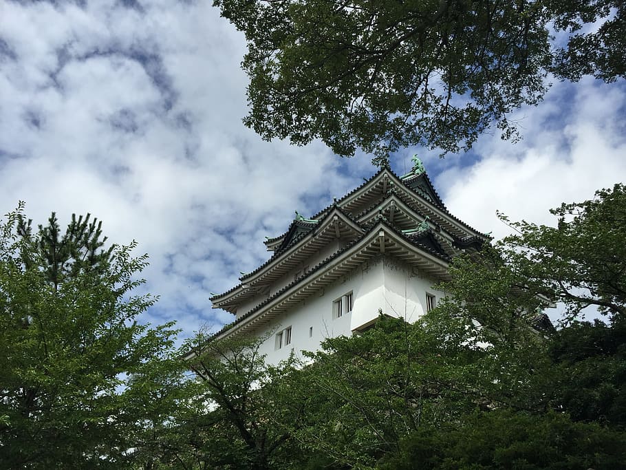
(和歌山城)(Wakayama Castle)
3.和歌山城
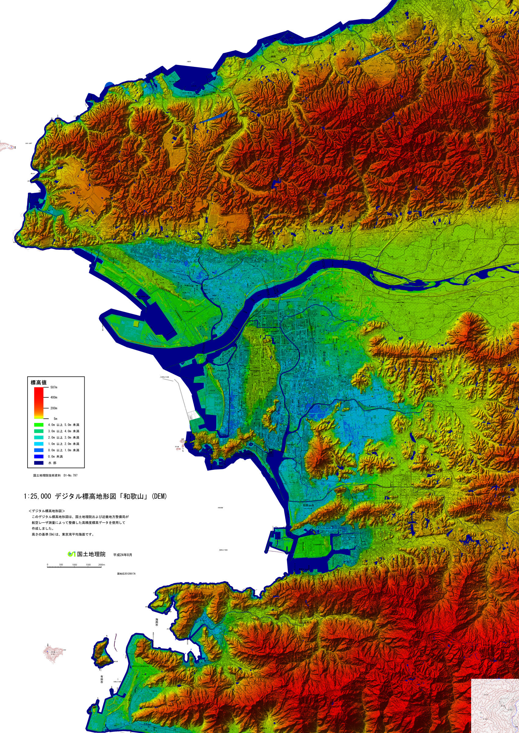
上の地図は「国土地理院」の「デジタル標高地形図(和歌山)」から引用した地図である。
地図の上方に大きく蛇行しながら和歌山湾に注ぐ「紀ノ川」、その中流あたりに南側を山地として和歌山湾に突き出す、南北に走る台地が「緑色」で描かれている。その台地の北端付近、紀ノ川に至る手前、台地の右側に小さな「城の地図記号」のような形をした「濃い青色」が見える、これが和歌山城を囲む「内堀」である。これまで見てきた江戸城、大阪城、名古屋城と同じように和歌山城は、市の中心部に位置する小高い台地、標高48.9mの「虎伏山」(とらふすやま)の山頂に築かれいる。城の北部を流れる紀の川の支流を天然の「外堀」とした堅固な城である。
「藩祖」である徳川頼宣は、第二代将軍徳川秀忠に駿府(静岡)から紀伊(和歌山)に転封されたのも「秀忠が自らの力を見せつけるためであった」と言われているように、幕府将軍家とは微妙な関係にあった。そのような関係にありながら、徳川頼宣は1621年より城の大改修と城下町の拡張を始めた。しかし、その規模が非常に大きく、堀も拡張しようとしたため、幕府将軍家より謀反の嫌疑をかけられ中止させられてしまった場所には「堀止」という地名がある。
このように「地名には歴史上の出来事が残されている」のである、「地名は『歴史の語り部』」と筆者が感じる所以である。
4.昭和南海地震
下の地図は「国土地理院」のホームページで公開されている「デジタル標高地形図(近畿地方)」から引用したものである。
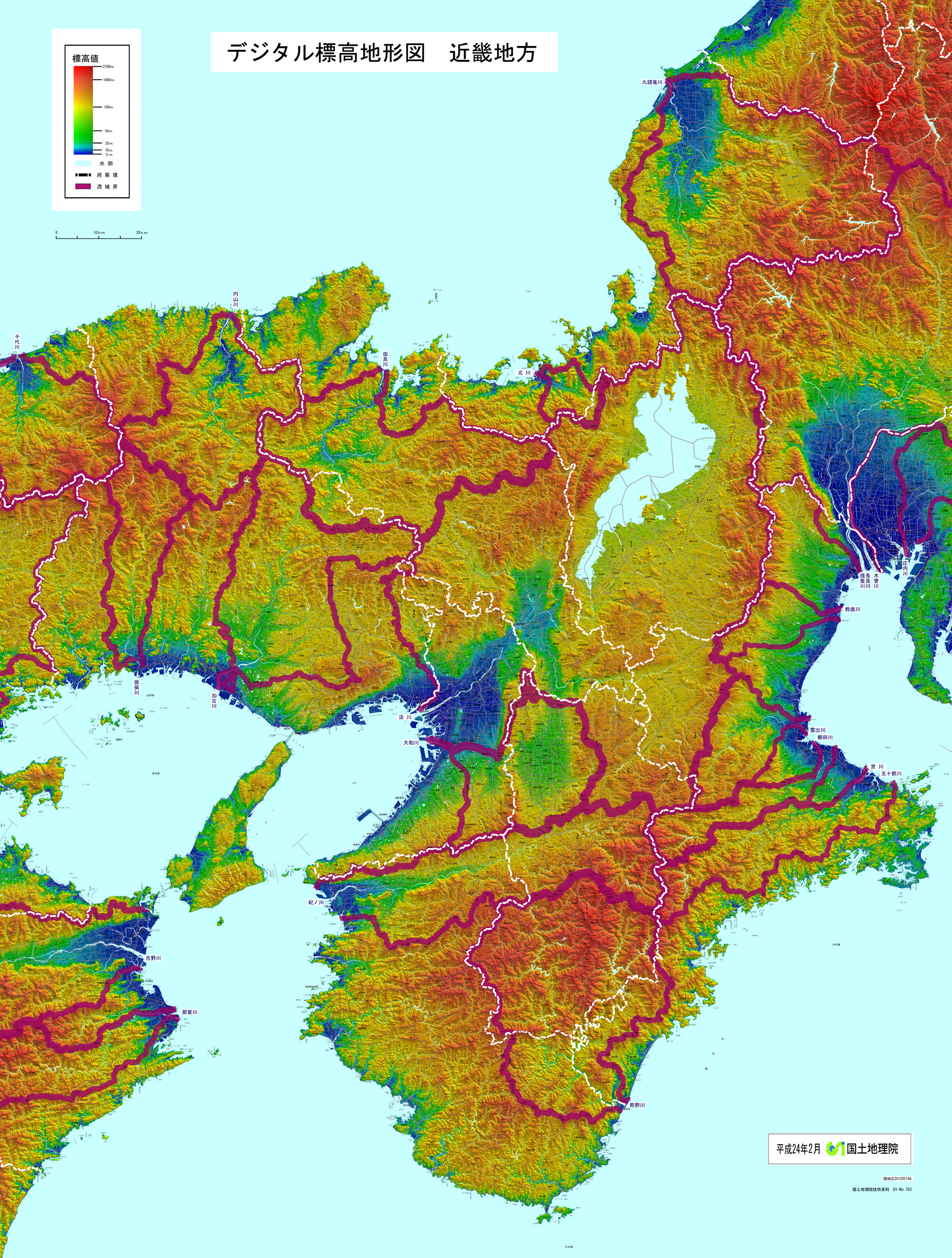
和歌山市の真ん中を東西に流れる紀ノ川に沿う三重県から連なる山地が、淡路島を通り四国の徳島県に繋がっているのが明確に解る、これが世界最大級の断層帯、日本列島を横切り九州に繋がる「中央構造線」である。
前述「3.和歌山城」に引用した「国土地理院のデジタル標高地形図(和歌山)」を見ると、和歌山市の南の方に青く湾曲した一帯が見える、和歌浦に面した「海南市」である。その場所に次の「自然災害伝承碑(地震・津波)」がある。
| 概要 | |
| 碑名 | 南海道地震津波浸水水位 |
| 災害名 | 昭和南海地震 (1946年12月21日) |
| 災害種別 | 地震・津波 |
| 建立年 | 1991 |
| 所在地 | 和歌山県海南市名高 |
| 伝承内容 | 昭和21年(1946)12月21日に発生した昭和南海地震により襲来した津波の到達と水位を示している。海南地区では地震後40分で第1波が到達し、その後第2波が最大となり、津波の高さは湾奥で3.21mにのぼった。 |
「理科年表」(国立天文台(編)丸善出版(刊))によるとこの昭和南海地震による被害状況は「死者1,330人、家屋の全壊11,591棟、半壊23,487棟、流出1,451棟、焼失2,598棟」であった。
1944年12月7日起きた地震が、懸念されている南海トラフ巨大地震の予想震源域の東側部分、「東南海」で発生したマグニチュード7.9の「海溝型地震(プレート境界型地震)」であった「昭和東南海地震」であったが、この2年後、1946年12月21日には予想震源域の西側部分、「南海」で発生した、和歌山県南方沖、深さ24キロを震源とするマグニチュード8.0の「海溝型(プレート境界型)」の巨大地震の自然災害伝承碑(地震・津波)である。
この地震に関する自然災害伝承碑は海南市にのみ建てられているが、この地震の規模から、先に引用した「デジタル標高地形図(和歌山)」の地図にも和歌山平野の低地の広がりからも明らかなように、和歌山市にも、その奥の大阪にも被害を与えたことが想像できる。1854年12月24日に発生した「安政東南海地震」では、津波が大阪湾の奥、神戸にまで達し、兵庫県明石市には「自然災害伝承碑」が建てられているからである。
5.「液状化」と「津波避難の盲点」に備えるキャプティブ
南海トラフ巨大地震の予想震源域は、陸地に非常に近い場所である。そのため、早いところでは津波が数分以内に押し寄せる危険性がある。また、震度6弱程度の揺れでも、沿岸部では液状化や地盤沈下が発生すると言われていることから、液状化が発生して、避難を困難にする危険性がある。30cm程度の浸水でも歩行は困難であり、クルマも動かないと数々の報道にもある。
「大地震=津波リスク」と津波ばかりに目が行くが、大きな揺れは川の堤防を決壊させ浸水させる危険性が大きい。こういった事態を見据えた対応策を練っているか。身の回りにどんなリスクがあるのか、避難所までの道のりは大丈夫なのか、ハザードマップでの確認が求められる。これが企業の場合、更に事前の対策は重要になるが果たして、そういう事態に備えたプランになっているのであろうか。
「RM68 地名に潜むリスクに備えるキャプティブ 3(「干拓地」東京)」で記した「表層地盤増幅率」(地震の揺れの強さは、その地盤が堅固かどうか、「表層地盤」(土地の表層近くの浅い部分)の揺れの大きさを数値化したもの)を「国立研究開発法人防災科学技術研究所」(NIED)が公表している「地震ハザードステーション」、その「地震ハザードカルテ」で、「和歌山県庁」(和歌山市小松原通一丁目 付近)を「診断」してみたら、液状化が懸念されるような、次のような結果となった。
表層地盤増幅率
Surface ground amplification factor
地盤増幅率 1.85 微地形区分 砂丘 30m平均S波速度 194m/s
ゆれやすさ全国上位5%
Ground amplification factor 1.85
Microtopography: Sand dunes
30m average S-wave velocity 194m/s
Top 5% of the country in terms of susceptibility to tremor
これまで本コラムで何度も触れてきたが、液状化リスクは「生産設備の回復遅れ」や「製品の搬出困難」を引き起こし企業業績に大きなマイナスの影響を与える可能性が高いリスクである。しかし、日本で販売されている一般的な地震保険では、直接の「物的損害:PD (Property Damage(プロパティ・ダメージ)」のみが補償される、「事業の中断による収益低下リスク:BI(Business Interruption)(ビジネス・インタラプション)」は補償されていない。
欧米の地震保険では、「物的損害:PD(Property Damage)」に加え、この地震による「事業の中断による収益低下リスク」(「Business Interruption(ビジネス・インタラプション):BI」)が補償されているのが普通である。「事業の中断による収益低下リスクへの対応」が無ければ「地震保険として意味が無いから」である。
ここにキャプティブを設立する大きなメリットが存在する。日本では得ることが難しい「地震保険の補償:事業の中断による収益低下リスク」をキャプティブからの再保険(保険契約者から見れば再々保険となる)を引き受けるロンドン・マーケットの再保険会社で確保して日本の元受保険会社に提供することによって、地震による「事業の中断による収益低下リスク」も補償することができるからである。
今回のまとめ
損害保険会社の経営コンサルタントを委嘱されていた頃、営業部隊である親会社の法人部門のスタッフと全国の企業を廻る機会が多くあった。「地震の際のBCP」に関して話を聞くことも多かったが、「地震が起きたときの態勢はどうされているのですか?」と尋ねても、「こうやって電話の連絡網を作成して」と説明をされるので、「執務時間外に地震が発生した場合には多くの方々はご自宅ですが、自宅からこの本社までの距離はどのくらいあるのか把握されていますか?」と質問したことがある。
「連絡網があると『連絡が付く』という前提でモノゴトが始まってしまう危険性」は大きいからである。本来のコンティンジェンシープランというものは、「プランA」が機能しない場合には「プランB」、それでも機能しない場合には「プランC」といくつもの「代替プラン」を構築して初めて完全に近い形で機能していくものである。
ところが、筆者がインタビューをおこなった、その多くが名だたる企業であったが、こういう企業でもこのような代替プランを構築していた企業は一社も無かった。「プランの見直し」を定期的におこなっている企業も少なく、「BCPができたらそのまま」の企業がほとんどであったことを記憶している。
その背景にあるのは、「リスクマネジメントの専門企業を起用してBCPが作成されていないこと」が挙げられるであろう。社内で集めたスタッフがマニュアル本を見ながらBCPを構築しているケースがほとんどであった記憶がある。これでは、「その企業特有のリスク」を含めた的確なリスクマネジメントをおこなうことが難しく、当然「対応策」も的確に案出することは困難である。
中小企業庁のホームページには、「BCP(事業継続計画)とは、企業が自然災害、大火災、テロ攻撃などの緊急事態に遭遇した場合において、事業資産の損害を最小限にとどめつつ、中核となる事業の継続あるいは早期復旧を可能とするために、平常時に行うべき活動や緊急時における事業継続のための方法、手段などを取り決めておく計画のことです。」とある。
「計画を立てるためには綿密な分析が必要である」はずであるが、この分析がどこまで詳細に、また入念になされているのであろうか、多くの企業の経営企画部門と方々とお話をしてきたが、その多くでは「まず計画有りき」という印象であったことは否めない。「計画が先行して、分析が後追い」になっていることを感じることが多く、計画の実効性に疑問符が付くBCPが多かったと記憶している。
「事象の分析」はできていても、「その背後にある、その事象を発生させる『リスクの分析』」という視点が抜けているからである。この「リスクの分析」という視点とスキルを得るためには日々リスクマネジメントを業務としておこなうことが必要であり、「自社でリスクを取る」というコンセプトで設立されるキャプティブが大きな効用をもたらすと言えるのではないだろうか。
執筆・翻訳者:羽谷 信一郎
English Translation
Risk Management (RM) 74 – Captives prepared for “Risk in place names” 9 (“Kii-Dainagon”, Wakayama)
When Global Link launched its captive business in 2012, the most difficult part was the translation of the word ” captive ” into Japanese. When I told my family that the term “private insurance company”, which had been commonly used until then, was a translation of captive, they said, “Private? I have no idea”. The reason for this was that corporate management is often not an expert in insurance and risk management, and the concept needed to be easily understood by them.
After a lot of thought, I arrived at the term “own insurance company”, which was proposed by saying that a captive is an insurance company dedicated to its own company, so why not use it as such? At the time, the term did not appear anywhere when searching the internet, but I have been trying to make the term stand on its own.
In writing this column, I decided to search for captives on the internet and checked Eijiro on the web (ALC Co., Ltd.), which I always use to translate my column articles into English, and found the following information. The result of 10 years of hard work?
captive
Noun
Prisoner of war, hostage
Captive (of love, etc.)
Captive ◆ insurance company dedicated to its own use
Adjective
Captive, imprisoned.
As one might expect, the road to introducing a ” new concept ” to the world is not a smooth one. The Edo period, which opened up the long, warring, warring states period with the unification of Japan under Ieyasu Tokugawa, became “an era that fundamentally changed the world and the way people thought about the world up until then”.
In a contribution to this column on 26 July 2020, entitled “RM 40: What weapons will survive the paradigm shift?” , a “paradigm shift” – in other words, a 180-degree change in the way of thinking and values that had previously existed – has taken place.
The term “paradigm ” is a concept meaning ” a fundamental change in the way of thinking of an era “, but there was no suitable word when translating it into Japanese, and the term ” paradigm ” permeated the language. It is as if the word “captive” is more commonly used as it “fits” better, even though the translation was painstakingly worked out with the company’s own dedicated insurance company.
One word that emerged in the Edo period that represents such a paradigm shift is “clan”.
In “What is a clan and how was ‘Edo no Taihei’ born?”(Tatsuo Fujita (author), Chuokoron Shinsha) states that “It should be noted in advance that the expression ‘han(clan)’ was rarely used in the Edo period and was called ‘kuni’ or kachu.” The term “clan” generally became popular from the end of the Edo period to the time of the abolition of feudal domains in 1871″.
In historical dramas set in the Edo period, the line “My clan was…” is often used, but from the perspective of historical research, it seems to be questionable, and although it is common to refer to the ruling system of the Edo period as the bakuhan system, in fact the term “clan” was never widely used throughout the Edo period.
1. what is a “han (clan)”?
I remember learning in my Japanese History class in high school that a clan was a territory controlled by a feudal lord who was granted a fiefdom of 10,000 koku or more during the Edo period.
The word “han ” was used in ancient China as a term for the territory ruled by feudal lords. In the Edo period, Confucian scholars are said to have derived the term from the fact that feudal lords who were given fiefdoms by the shogunate were called “lords” and their fiefdoms were called “han”, but as mentioned at the beginning of this article, during the Edo period the term “han” was never officially used and the fiefdoms of the lords were called “kuni” or “kachu”, and the term became apparent near the end of the “shogunate-han system”. The term has only emerged in history near the end of the “bakuhan system”.
Similarly, the term “shogunate’s direct domain” is called “tenryo”, which, like han, has been in use since the Meiji era. The truth is hidden even in words that we use because we think they are “commonplace”.
Among these clans, the three most prestigious were the three Tokugawa clans of Owari, Kii and Mito, which were the highest-ranking families in the Tokugawa clan and were allowed to call themselves Tokugawa, and to use the crest of the three-leaf hollyhock. As is clear from the map, these three families were the ” enemy ” at the time of the Battle of Sekigahara, and had territories at strategic points on the highways and sea routes from the west and north-east to Edo, and were required to function as a “fortress” to protect the shogunate.
2. the Kishu Tokugawa family
During the Azuchi-Momoyama period, Hidenaga Toyotomi, the younger brother of Hideyoshi Toyotomi, supported Hideyoshi as the centre of the Toyotomi administration and controlled domestic and foreign political and military affairs, and was a feudal lord of about 1.1 million koku, covering the Yamato (present Nara Prefecture), Kii (present Wakayama Prefecture), Izumi (present southern Osaka Prefecture) and Kawachi (present eastern Osaka Prefecture) areas. During Hidenaga’s reign, Wakayama was called Wakayama, which is now Wakayama, but Hideyoshi ordered Hidenaga to build a castle here, and after the castle was completed, he called the area Wakayama and left it as the name of the place in a letter.
The website of the “150th anniversary of Wakayama Prefecture” states the following about the origin of the name Wakayama:
In 713 (6th year of the Wado Period), there was a central government decree to name the country using two favoured characters, and from this time onwards, the name was written as “Kii-no-kuni “. In the Nihon Shoki (Chronicles of Japan), it is called “Kinokuni”, which derives from the fact that this prefecture was first called “Ki no Kuni”.
The origin of the name Wakayama was originally the name of a place where the feudal lords lived during the feudal government era, and there are various theories as to the origin of the name, but the prevailing theory is that the name Wakayama was formed because Wakaura was the best known name from olden times. The name was unified to “Wakayama” for a time during the domain period, but was changed again to “Wakayama”.
*This text is based on the “History of Wakayama Prefecture, Vol. 1”.
In the Edo period, after the fall of the Toyotomi family, Yorinobu Tokugawa, the tenth son of Ieyasu Tokugawa, entered Wakayama Castle in 1619 as the lord of the 555,000-koku castle, and from then on Wakayama flourished as the castle town of the Kishu Tokugawa family. According to the Wakayama City website, “The city was equipped with a sewerage system called ‘Daisuidou(Great Sewerage System)’, and by the late Edo period it was the eighth largest modern city in Japan, with a population of about 90,000.”
3. Wakayama Castle
The map above is taken from the Digital Elevation Topographic Map (Wakayama) of the Geographical Survey Institute.
The Kino River, which meanders widely and flows into Wakayama Bay, is shown in the upper part of the map, and a plateau running north-south with mountains on its southern side jutting out into Wakayama Bay is drawn in green around its middle reaches. Near the northern end of the plateau, just before the Kino River, on the right side of the plateau, you can see a “dark blue ” area shaped like a small “castle map symbol”, which is the “inner moat” surrounding Wakayama Castle. Like Edo Castle, Osaka Castle and Nagoya Castle, Wakayama Castle was built on a small plateau in the centre of the city, on top of the 48.9m-high Torafusuyama mountain. It is a solid castle with a natural “outer moat ” made from a tributary of the Kino River, which flows through the northern part of the castle.
Yorinobu Tokugawa, the “founder of the clan”, had a delicate relationship with the shogunate family, as it is said that he was transferred from Sunpu (Shizuoka) to Kii (Wakayama) by the second shogun, Hidetada Tokugawa, “so that Hidetada could show his power”. Despite this relationship, Yorinobu Tokugawa began a major renovation of the castle and expansion of the castle town in 1621. However, the scale of the project was so large and the moat so extensive that the shogunate was forced to cancel the project after being accused of treason by the shogunate family, and the place was named “Horidome”.
In this way, “place names contain historical events”, which is why the author feels that “place names are ‘storytellers of history'”.
4.Showa Nankai Earthquake
The map below is taken from the Digital Elevation Topographic Map (Kinki Region) published on the website of the Geographical Survey Institute.
It can be clearly seen that the mountain range from Mie Prefecture along the Kino River, which runs east-west through the middle of Wakayama City, passes through Awaji Island and connects to Tokushima Prefecture on Shikoku Island.
The GSI’s digital elevation topographic map (Wakayama), quoted in “3. Wakayama Castle” above, shows a curved blue area to the south of Wakayama City, which is Kainan City, facing Wakaura. The following “Monument of Natural Disaster Lore (Earthquake and Tsunami)” is located there.
Outline.
Monument name Nankaido Earthquake Tsunami Inundation Level
Name of disaster Showa Nankai Earthquake
(21 December 1946)
Type of disaster Earthquake/tsunami
Year erected 1991
Location Nadaka, Kainan City, Wakayama Prefecture
Description of legend This map shows the arrival and water level of the tsunami caused by the Showa Nankai Earthquake that occurred on 21 December 1946. In the Kainan area, the first wave arrived 40 minutes after the earthquake, followed by the second wave, which was the largest, and the tsunami reached a height of 3.21 m deep in the bay.
According to the “Chronological Table of Science” (National Astronomical Observatory of Japan (ed.), Maruzen Publications), the Showa Nankai Earthquake caused “1,330 deaths, 11,591 houses totally destroyed, 23,487 houses half destroyed, 1,451 houses swept away and 2,598 houses destroyed by fire”.
The 7 December 1944 earthquake was the Showa Tonankai Earthquake, a magnitude 7.9 trench-type earthquake (plate boundary earthquake) that occurred in the eastern part of the expected epicentre of the Nankai Trough giant earthquake, the Tonankai, but two years later, on 21 December 1946, an earthquake occurred in the western part of the expected epicentre area, the Nankai. This is a monument to natural disasters (earthquakes and tsunamis) from a massive magnitude 8.0 trench-type (plate boundary type) earthquake with its epicentre off the southern coast of Wakayama Prefecture at a depth of 24 km.
Although the only natural disaster legend monument for this earthquake was erected in Kainan City, it can be imagined from the scale of this earthquake that it caused damage to Wakayama City as well as to Osaka, which is located behind it, as is clear from the lowland extent of the Wakayama Plain on the “Digital Elevation Topographic Map (Wakayama)” map quoted earlier. The “Ansei Tonankai Earthquake” of 24 December 1854 caused a tsunami that reached Kobe, deep in Osaka Bay, and a monument to the legacy of natural disasters has been erected in Akashi City, Hyogo Prefecture.
5. captives to prepare for “liquefaction” and “blind spots for tsunami evacuation”.
The expected epicentre of the Nankai Trough giant earthquake is very close to land. Therefore, there is a risk of tsunami surging within minutes at the earliest point. There is also a risk of liquefaction, which could make evacuation difficult, as even an earthquake of intensity 6 or lower is said to cause liquefaction and land subsidence in coastal areas; even 30 cm of flooding would make walking difficult and cars immobile, according to numerous reports.
The risk of tsunamis is the focus of many people’s attention, but there is a great risk that large tremors could cause rivers to burst their banks and flood the area. Are you preparing for this kind of situation? It is necessary to check hazard maps to see what risks are around you and whether the path to evacuation centres is safe. In the case of companies, it is even more important to take precautionary measures, but is there a plan in place for such a situation?
The National Research Institute for Earth Science and Disaster Prevention (NIED) has published the “surface ground amplification factor” (the strength of earthquake shaking is quantified by the magnitude of shaking of the “surface ground” (the shallow part of the land near the surface) to determine whether the ground is solid), as described in RM68 Captive 3 (“Reclaimed land”, Tokyo). The following results were obtained from the “Earthquake Hazard Station” published by the National Institute for Earth Science and Disaster Prevention (NIED) and its “Earthquake Hazard Chart” for the Wakayama Prefectural Government (near Komatsubaradori 1-chome, Wakayama City), which indicated that liquefaction was a concern.
Surface ground amplification factor
Ground amplification factor 1.85
Microtopographic classification Dune
30 m average S-wave velocity 194 m/s
Top 5% of the country in terms of ease of shaking
Ground amplification factor 1.85
Microtopography: Sand dunes
30m average S-wave velocity 194m/s
Top 5% of the country in terms of susceptibility to tremor
As has been mentioned many times in this column, liquefaction risk is a risk that is highly likely to have a significant negative impact on corporate performance, causing “delays in the recovery of production facilities” and “difficulties in transporting products out of the country”. However, general earthquake insurance policies sold in Japan only cover direct “Property Damage (PD) ” and do not cover ” Business Interruption (BI) (Business Interruption) risk (risk of loss of earnings due to business interruption) “. is not compensated.
In Europe and the US, earthquake insurance policies usually provide coverage for “risk of loss of earnings due to business interruption (Business Interruption: BI)” in addition to “Property Damage (PD)” caused by the earthquake. This is because “earthquake insurance is meaningless” if it does not “address the risk of loss of earnings due to business interruption”.
This is a major advantage of establishing a captive. By securing “earthquake insurance coverage: risk of loss of earnings due to business interruption”, which is difficult to obtain in Japan, through a reinsurance company in the London market that underwrites reinsurance from the captive (from the policyholder’s perspective, this would be reinsurance), and providing it to the Japanese primary insurer, “risk of loss of earnings due to business interruption” due to earthquakes can be covered. This is because it also compensates for the “risk of loss of earnings due to business interruption” caused by earthquakes.
Summary of this issue
When I was commissioned as a management consultant for a non-life insurance company, I had many opportunities to visit companies across Japan with staff from the parent company’s corporate division, which was the sales force. I often asked them about their BCPs in the event of an earthquake, but when I asked them, “What are you doing about your preparedness in the event of an earthquake?” I asked, “If an earthquake occurs outside office hours, many of you are at home.
The reason is that there is a great risk that if there is a network of contacts, things will start on the assumption that ‘we can be contacted’. A contingency plan should function in a near-perfect form only after a number of alternative plans have been constructed, such as Plan B if Plan A does not work, and Plan C if Plan C still does not work.
However, none of the companies interviewed by the author, many of which were well-known companies, had established such alternative plans. Few companies regularly reviewed their plans, and most of the companies I interviewed simply left their BCPs as they were.
One of the reasons behind this may be that BCPs were not prepared by employing a company specialising in risk management. In most cases, the BCPs were prepared by staff gathered within the company, looking at manual books. This makes it difficult to carry out accurate risk management, including ‘company-specific risks’, and of course it is also difficult to accurately draft ‘countermeasures’.
The website of the Small and Medium Enterprise Agency states that “BCP (Business Continuity Plan) refers to the activities that should be carried out under normal circumstances and the methods and means for business continuity in an emergency, in order to enable the continuation or early recovery of core business operations while minimising damage to business assets in the event of an emergency situation such as a natural disaster, major fire or terrorist attack. It is a plan that defines the activities to be carried out under normal circumstances and the methods and means for business continuity in the event of an emergency, in order to minimise damage to business assets and enable the continuation or early recovery of core business operations.” The following is a summary of the plan.
However, I have spoken to people in the corporate planning departments of many companies, and I can’t deny that in many cases, the impression I have had is that ‘the plan comes first’. I remember that I often felt that “planning comes first and analysis follows”, and that there were many BCPs with question marks over the effectiveness of the plan.
This is because, although the ‘event analysis’ is completed, the perspective of “analysing the risks behind the event that could cause the event to occur” is missing. In order to acquire this ‘risk analysis’ perspective and skills, it is necessary to carry out risk management on a daily basis, and it can be said that captives established on the concept of “taking risks on their own” can be of great benefit.
Author/translator: Shinichiro Hatani