
リスク対応策 2022.06.15
RM73「地名に潜むリスク」へ備えるキャプティブ 7(「瓜生島沈没」大分)
目次
Copyright © Shinichiro Hatani 2022 All rights reserved
For those who prefer to read this column in English, the Japanese text is followed by a British English translation, so please scroll down to the bottom of the Japanese text.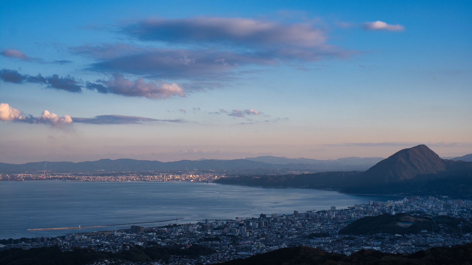
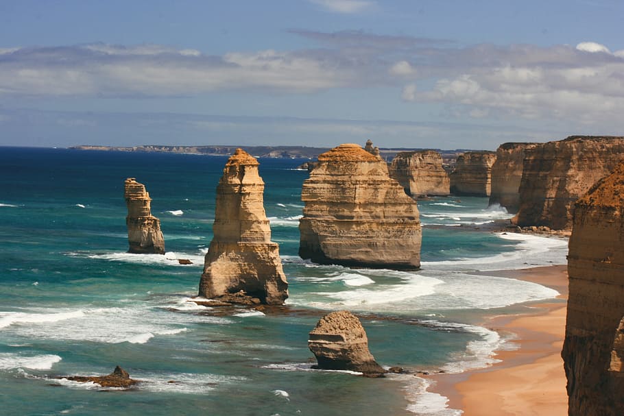
(本年2月第70回の記念大会となった「別府大分毎日マラソン」のコース、別府湾に面し、手前に別府市、右手に高崎山、遠くに大分市を一望する。)
(The course of the Beppu Oita Mainichi Marathon, which celebrated its 70th anniversary in February this year, facing Beppu Bay, with Beppu City in the foreground, Mt Takasaki on the right and Oita City in the distance.)
筆者がこの世に生を受けた地は大分県大分市。曾祖父が別府に開いた旅館を長男である祖父が継ぐことになっていた。しかし、私にそのDNAが見事に受け継がれているが「海外雄飛の夢」を持っていたようで、大学を出ると満州大連市に渡り「満鉄(南満州鉄道)」に就職、そこで父が生まれたが、「本籍地」は別府から動かさず、終戦とともに引き揚げて来たときも大分に居を構えたため「別府市が本籍地のまま」であった。
父は国家公務員として全国を転々としたが、「大分への想い」があったためか本籍地は動かさなかった。そんな父が30年前鬼籍に入った後も「父への想い」からか、筆者も本籍地を動かしていない。そのため、「戸籍謄本等が必要になると別府市役所に手紙で依頼」している。そんなこともあってか、大分には3歳までしかいなかったが大分への想いには募るものがある。母も別府市の隣、国東半島の豊後高田市出身であり、数年前「母の米寿の記念」にと、母が居る岐阜県に行き、クルマで大阪へ、そこからフェリーで別府へ。別府「鉄輪」(かんなわ)の旅館に宿泊しながら、従兄弟家族が住んでいる母の実家訪問や墓参りをおこなった。
そんな別府に縁もあるためか、たまたま気になって読んだ本に「南蛮船の見える町―わがバテレン・宗麟・瓜生島 加藤 知弘 (著) 石風社(刊)」があったが、最近、本コラムに「地震のこと」を記しているので取り出して再読してみた。「湯布院の奥から、大分市内、そして別府湾に注ぐ大分川、この河口の沖合に陸地と砂州で繋がった島、南蛮貿易で栄えた『瓜生島』と『久光島』があったが、この2島が、1596年9月発生した『慶長豊後地震』で、一夜にして海に沈み、島の住人の多くが犠牲になった」という「伝説」が綴られていたのを記憶していたからである。
グローバル・リンクは、「キャプティブ」、とりわけ「地震保険キャプティブ」の設立コンサルティングを事業の柱としているため、この伝説に強い関心を持ち、種々調べてみると「瓜生島沈没」を発生させた「リスクの正体」に辿り着くことができた。
由布院に源を発し別府湾に注ぎ込む「大分川」の下を長さ1,000kmに及ぶ長大な断層「中央構造線」が通っている。政府「地震調査研究推進本部」のホームページにある「大分県の地震活動の特徴」のページには、この「慶長豊後地震」に関して「歴史の資料によると、1596年別府湾の地震(M7.0)では別府湾周辺の各地に大きな被害が生じました。」という記述がある。そのページに記されている「大分県の地震活動の特徴」を記したものが下図である。
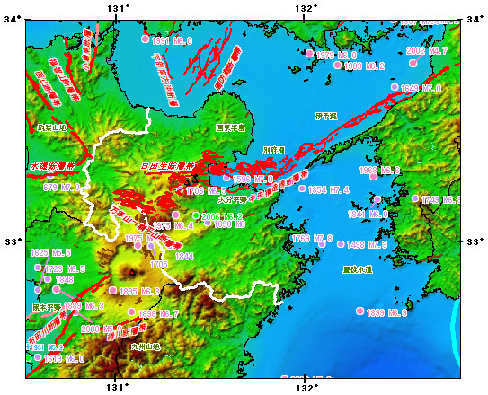
(出典:政府「地震調査研究推進本部」のホームページ内「大分県の地震活動の特徴」)
(Source: “Characteristics of seismic activity in Oita Prefecture” on the website of the Government’s Headquarters for Earthquake Research Promotion).
1. 大分県を走る「中央構造線」
関東から新潟にかけての大地溝帯「フォッサマグナ」を境に、日本の西半分は「ユーラシアプレート」、東半分は「北米プレート」とその「土台」が別れている。中央構造線は茨城から関東に入り、諏訪を経て、三重、和歌山、さらに四国を縦断、上図のように大分に入り、九州の八代、熊本を経て太平洋へ抜ける長大な大断層帯である。
九州、大分県から熊本県に至る一帯を走る中央構造線上には、別府温泉をはじめ湯布院と有名な温泉地が連なっていて、この温泉地熱現象には新しい火山活動や地震の予兆を感じさせる。
冒頭記したとおり、400年前の「慶長豊後地震」によって、別府湾に沈んだ「瓜生島」の話が語りつがれてきたが、歴史的資料が乏しく、あくまでも「瓜生島沈没」は伝説の域を出なかった。しかし、近年様々な研究者によってその実態が解き明かされつつある。
「古代地名語源辞典」(楠原祐介ほか(編著) 東京堂出版(刊))には、大分(おおいた)は「おほいた」と読み「オホは美祢(みね)イタはキダの転で、『刻まれたような地形』、つまり段丘を呼んだ地名である。」と記されている。
この「段丘」とは、地殻変動等によってもともと海底や川底であった場所が隆起することによって形成される「隆起地帯」に発達した地形であり、プレートが複雑に入り組んでいて地震の多い地域で多くみられる地形である。
2.段丘のリスク
「平野が語る日本史(角川ソフィア文庫)」(日下 雅義(著)KADOKAWA(刊))には、 「段丘は平野の一部といえるが、地形の細かい特徴や開発の歴史の面からは、やはり特殊なものとしてとらえる必要がある」と記されている。段丘はその形成過程によって包含するリスクは異なっている。
この段丘は「周囲の地形によって分類されること」は、一般的には次のとおり分類されている。
河川の近くに形成される「河岸段丘」、海岸の近くに形成される「海岸段丘」、湖沼の近くに形成される「湖岸段丘」。
「おほいた」に由来する「大分」は地図にも明らかなとおり「海岸段丘」であり、その形成には次のような過程が考えられる。
(1) 波による海岸侵食が発生
(2) 侵食された砂が堆積
(3) 地殻変動により海岸が隆起
(4) 海底の段丘面が出現
このような過程を辿るが、地殻変動の起きやすい断層近くのためこの動きが何度も繰り返されるのが一般的である。つまり、「段丘のある地域」は地殻変動、地震が起きやすい地域なのである。
下の地形図は、国土地理院のホームページで公開されている「デジタル標高地形図」の「大分県」のページから引用したものである。
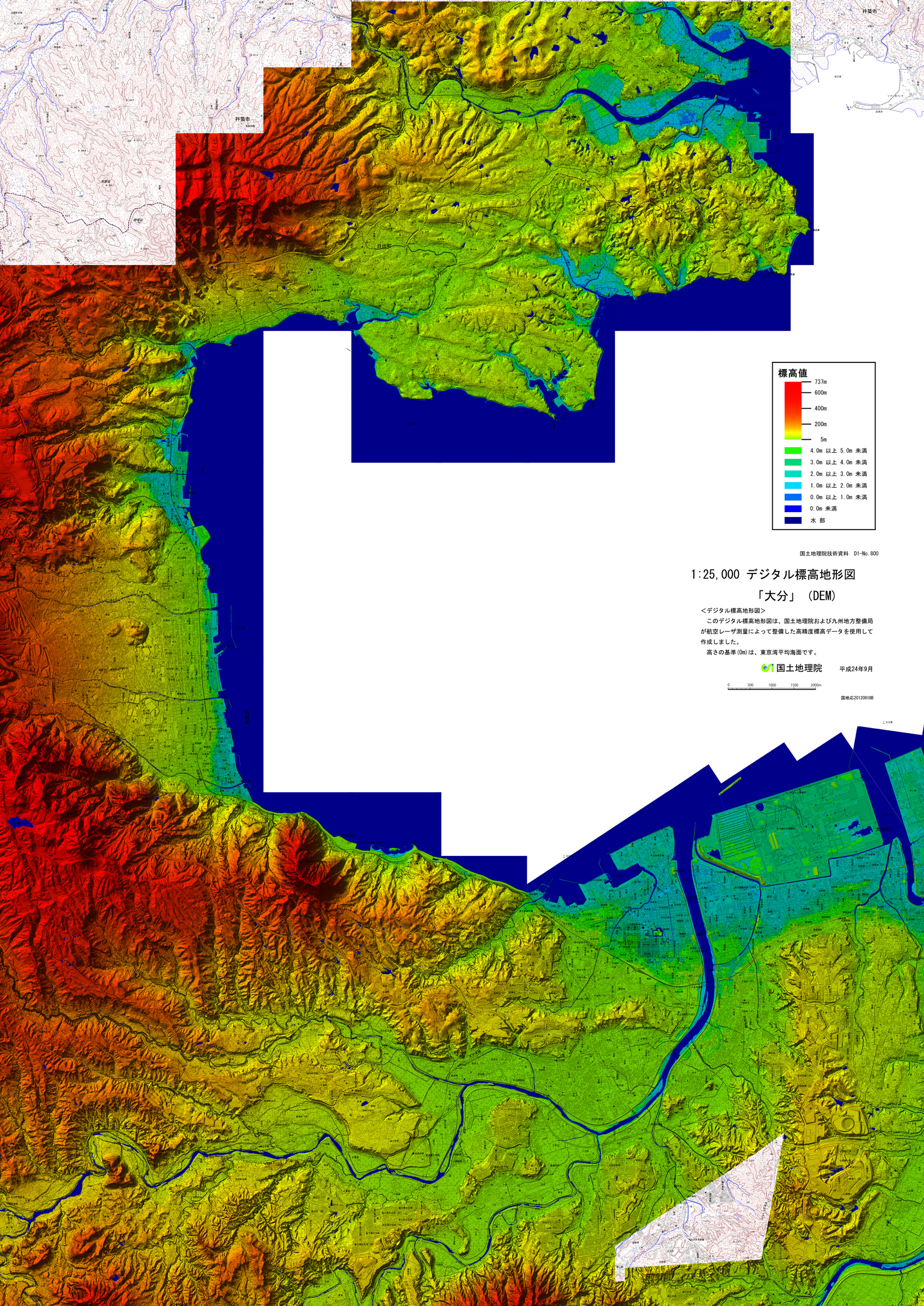
(出典:国土地理院のホームページ「デジタル標高地形図」「大分」)
(Source: GSI’s website ‘Digital Elevation Topographic Map’ ‘Oita’)
別府湾の北方、別府市から大分川が別府湾に注ぎ込む大分市にかけて「海岸段丘」の地形が広がっているのがよく解る。
3.活断層
「中央構造線」が陸地に入り込む場所のためか、大分県のホームページの「大分県の活断層調査」には、下図のように多くの活断層帯の存在が示されている。
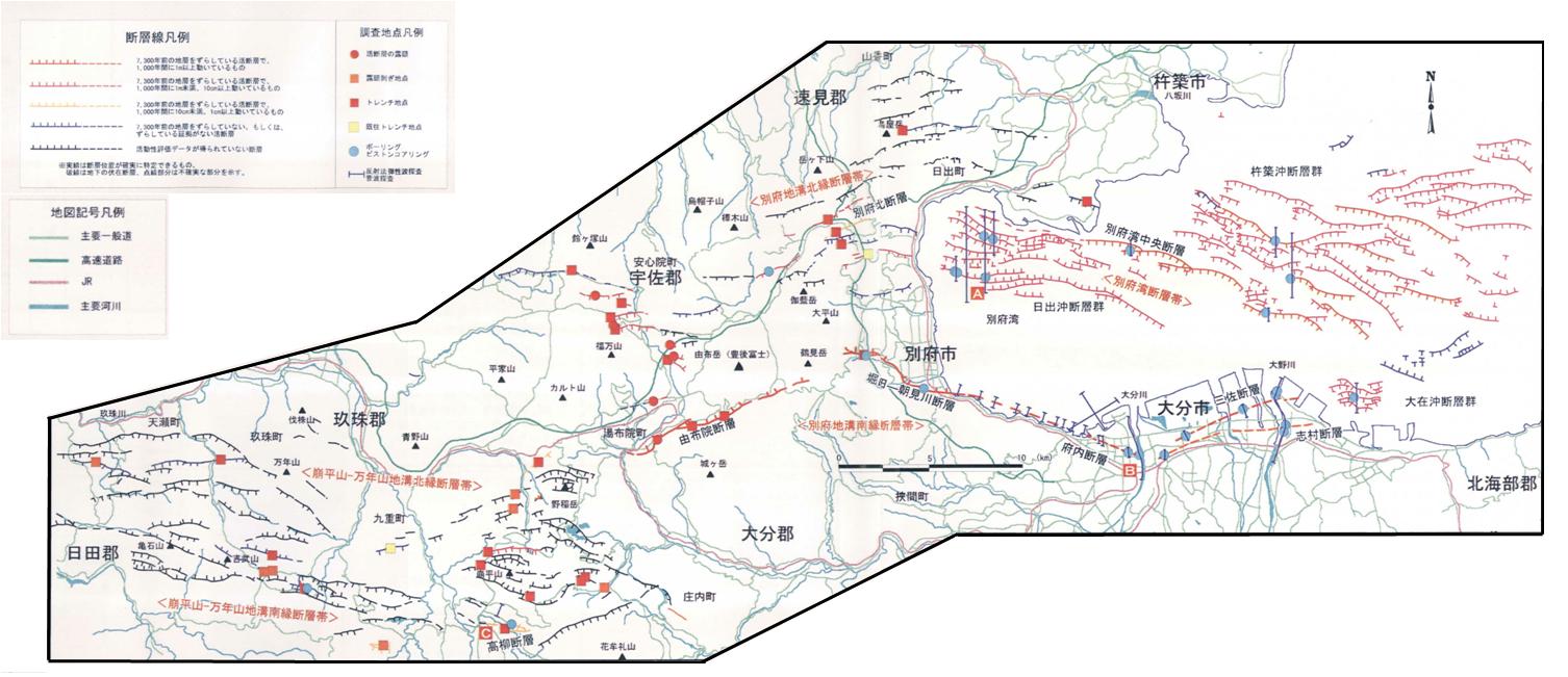
(出典:大分県ホームページ「大分県の活断層調査」)
(Source: Oita Prefecture website, ‘Survey of Active Faults in Oita Prefecture’)
同ホームページには「今回の調査により、調査地域内の活断層は、共通する性格をもつ次の5つのグループに分けられることがわかりました。」とあり、次のとおり記されている。
別府湾断層帯:
「別府湾中央断層」を中心とした海域の断層群
別府地溝南縁断層帯:
湯布院町から別府市にかけて調査地域の南端付近に分布する「由布院断層」と「堀田―朝見川断層」、そして今回の調査で大分市内の地下に存在していることが確認された「府内断層」「三佐断層」「志村断層」
別府地溝北縁断層帯:
玖珠町から日出町にかけて調査地域の北部に分布している断層群
崩平山-万年山地溝南縁断層帯:
九重町から玖珠町、天瀬町にかけての調査地域の南部に分布している断層群
崩平山-万年山地溝北縁断層帯:
九重町から玖珠町、天瀬町にかけての調査地域の南部に分布している断層群
大分県は「地震が起きやすい地」とは一般的には見られていないが、これほどの数の断層がある。「中央構造線」のなせる業である。
4.「瓜生島沈没」が教えるキャプティブの必要性
上図の九重町から玖珠町、天瀬町にかけての断層帯「崩平山-万年山地溝北縁断層帯」、この「崩平山」を読めるであろうか。「くえんひらやま、くえのひらやま」と読む、上から何かで押しつぶしたような「平板な山の形」をしているが、「朝日長者伝説」の一つで、「一夜にして崩れて平になった」から名付けられた名前とされている。読んで字のごとく、地震で「山体崩れ」を起こしたと推定される形の山である。
これだけの断層帯が存在する大分県である。そのことを物語るように、「大地震が起きた場合には大分市及び別府市の大半、由布市と日出町では震度6強以上、大分市及び別府市の一部では震度7」となる想定がなされている。大分県の想定では、海岸沿い及び干拓地では、「揺れそのもの」よりも被害が大きくなる可能性のある「広範な液状化現象」が1,000戸を越える家屋で起きる可能性が指摘されている。
企業が工場で生産した製品は、できるだけ安価な輸送手段で消費地に届けたいと考えるものである。そのため、工場は、一般的には港湾に近い場所に建設されるものであるが、このことは「液状化」に遭うリスクを高めることにもなっている。地震が発生して工場の建屋や製品、半製品等が受ける直接的な損害のみならず、この液状化による損害は、東日本大震災の際に関東地域で発生した大規模な液状化現象によって、「工場の生産回復及び製品の搬出」に大きな影響を与え、その損害額が大きかったことは記憶に新しい。「キャプティブ」を介した地震保険プログラムの必要性が強く叫ばれる所以である。
この液状化リスクは「生産設備の回復遅れ」や「製品の搬出困難」を引き起こす。そのため、企業業績に大きな影響を与え、企業収益の低下をきたす可能性が高いリスクである。しかし、日本で企業向けに販売されている一般的な地震保険では、直接の「物的損害:PD (Property Damage(プロパティ・ダメージ)」のみが補償される傾向が強く、損害保険会社がこの「事業の中断による収益低下リスク:BI(Business Interruption)(ビジネス・インタラプション)」を積極的に引き受けることはないと言われている。
一方、欧米では、ごく普通に販売されている地震保険は「物的損害:PD(Property Damage)」に加え、この地震による「事業の中断による収益低下リスク」(「Business Interruption(ビジネス・インタラプション):BI」)が補償されている、「物的損害リスク対応」だけでは片手落ちで「事業の中断による収益低下リスクへの対応」が無ければ「地震保険としての意味が無いから」である。
ここにキャプティブを設立する大きなメリットが存在する。日本では一般的ではない「地震保険の補償:事業の中断による収益低下リスク」をキャプティブからの再保険(保険契約者から見れば再々保険となる)を受けるロンドン・マーケットの再保険会社で確保して日本の元受保険会社に提供する、このことによって、地震による「事業の中断による収益低下リスク」を補償することができるからである。
「地震ハザードステーション」で大分市中心部の「表層地盤増幅率」を見ると以下の通りであった。
表層地盤
地盤増幅率(Vs=400m/s~地表) 2.07 微地形区分 三角州・海岸低地 30m平均S波速度(微地形) 170m/s
Surface ground
Ground amplification factor (Vs=400 m/s to surface) 2.07
Microtopographic classification Delta and coastal lowlands
30 m average S-wave velocity (microtopography) 170 m/s
ゆれやすさ全国上位3%
Top 3% in the country for ease of shaking
表層地盤増幅率は2を超えている、地震が発生した場合、「揺れが大きく増幅される、かなり地盤の弱い地域」と推定される数字である。
今回のまとめ
冒頭記した「南蛮船の見える町―わがバテレン・宗麟・瓜生島 加藤 知弘 (著) 石風社(刊)」にはこうある。
現在の別府湾に島影は全くない。円形の海面には、高崎山と臨海工業地帯の高煙突が影を落としているだけである。約三百八十年前(執筆当時から)まで、この別府湾に「瓜生島」「久光島」といった島々が浮かんでいたという。「瓜生島」は沖の浜とも言った。東西に伸びる三筋の町並みがあって、家数は千軒、威徳寺や住吉社、天満社、蛭子社、それに島津勝久の居館などがあった。沖の浜は府内の港で、全国の船舶が昼も夜も行き交う大きな港であった。
一五九六年九月四日(慶長元年閏七月十二日)午後、大地震があり、しばらくしてやんだので、住民がようやく安心したところに、海が鳴動を始め、人々は四方に逃げた。村里の水が干上がり、しばらくして山のような怒濤が押し寄せてきた。府内の町や近辺の村々、長浜神社なども流没し、「瓜生島」も沈没してしまった。
この伝説の伝える”沖の浜”港は、信頼できる史実として記録されており、一五九六年九月四日、大地震・津波に襲われて海没したのも史実である。
昨年、2021年9月10日、本コラムに投稿した「CA31 南海トラフ大地震(高知「黒田郡」沈没」)に記した「陸地の沈没」である。前述のとおり、別府湾に面する大分平野は、「地殻変動」が起きやすい場所であり、かつ「地盤の弱い地域」ということもあって、「瓜生島沈没」の伝説があると言われている。
しかし、この「瓜生島」を沖にある「岩盤でできた島」ではなく、大分川が堆積させた大量の土砂が形成した「砂州」と考えると、地震によって軟弱な地盤に「液状化現象」が起こり「土砂の中に埋没していった」と考えることができる。実在したかどうかについては諸説ある「瓜生島」であるが、そう考えていくと同書の著者、故加藤大分知弘大学名誉教授が記されているとおり、「伝説」ではなく「史実」の可能性が高いと考えられる。
このような「陸地の沈没」が考えられる地域は全国各地に存在する。日本は、国土の約75%が山地であり、 山地は谷が細かく入り組み、その斜面は急傾斜となり「段丘」が多くの地で見られるからである。懸念されている「南海トラフ巨大地震」が発生した場合、その影響を受ける地域では建物の揺れによる倒壊だけではなく、「東日本大震災」の際、東京湾沿岸を中心に液状化に依る被害が広く発生したように、「大規模な液状化現象」が起きる可能性が高い。
液状化は、堆積した砂の地盤が、干拓地等で水を多く含んでいる場所で起こり、地盤が液体状となるため建物は沈み込んでいく。東日本大震災の際、千葉県浦安市の多くの住居に発生したことはマスコミでも多く取り上げられたが、東京湾の沿岸部にある多くの「工場」「事務所」等でも大きな損害が発生したことはあまりメディアには出ていないため知られていない。
埋没しないまでも、工場が傾くと無論収容、装備されている機械類も傾く、そうなると生産が長期間不可能になり、企業収益に大きなマイナスの影響を与える。「地震リスク」と言うと多くの人が「建物が倒壊する、壊れるリスク」を考えるが、建物は土台さえしっかりしていればその復興に要する時間は短い、しかし「地盤の整備、強化」からおこなっていかなければならない「液状化リスク」は復興までの期間が長期化するという点で企業の収益に与える影響が実は大きいのである。
ただ、日本では「地震保険=物的損害リスクへの補償」と見なされてきたため、損害保険会社が、この「事業の中断による収益低下リスク」(英文では「Business Interruption(ビジネス・インタラプション):BI」を引き受けることは一般的ではない。ただでさえ不足がちな「地震保険キャパシティ(引受力)」を広範なリスクに適用して「地震保険キャパシティ」を払底させたくないからである。
一方、欧米で、ごく普通に販売されている地震保険は「物的損害:PD(Property Damage)」に加え、この地震による「事業の中断による収益低下リスク」(英文では「Business Interruption(ビジネス・インタラプション):BI」)も補償するものである、「物的損害リスク」だけでは片手落ちで「事業の中断による収益低下リスク」が無ければ「地震保険としての意味が無いから」である。
ここにキャプティブを設立する大きなメリットがある。この日本では一般的に手に入らない「地震保険の補償:事業の中断による収益低下リスク」をキャプティブからの再保険を受けるロンドン・マーケットの再保険会社で確保して日本の元受保険会社に提供する、このことによって、日本の元受保険会社は、地震による「事業の中断による収益低下リスク」を補償することができるからである。
「本当に怖いリスク、対処しなければならないリスク、経営に大きな影響を与えかねないリスク」に焦点を当てリスクマネジメント対応をするためには、この大きなメリットを活用する必要がある。そのリスクが顕在化する前に、「コロナ禍以上の日本にとっての最大級のリスク、巨大地震リスクに備える」ため、早急にキャプティブの設立を検討する必要があるのではないだろうか。
執筆・翻訳者:羽谷 信一郎
English Translation
Risk Management (RM) 73 – Captives prepared for “Risk in place names” 7 (“Sinking of Uryu Island”, Oita)
The author was born into this world in Oita City, Oita Prefecture. My grandfather, the eldest son, was supposed to take over the Japanese inn that his great-grandfather had opened in Beppu. However, he seemed to have had a dream of “flying abroad”, which I have successfully inherited from my DNA, and after leaving university he went to Dalian, Manchuria, to work for the Manchurian Railway (South Manchuria Railway), where my father was born, but he did not move his “domicile of origin” from Beppu, and when he returned to Japan after the war, he settled in Oita, so “Beppu City remained his “domicile of origin”.
My father moved around the country as a national civil servant, but he never moved his “domicile of origin”, perhaps because of his “love for Oita”. Even after my father joined the majority 30 years ago, the author has not moved “domicile of origin” either, perhaps because of the “love he had for Oita”. For this reason, “whenever I need a copy of “domicile of origin”, I write to the Beppu City Hall to request it”. Perhaps this is why, although I was only in Oita until I was three years old, my feelings for Oita are growing. My mother is also from Bungotakada City on the Kunitachi Peninsula, next to Beppu City, and a few years ago, to commemorate her ”88 years old”, I went to Gifu Prefecture where she lives, drove to Osaka and took a ferry from there to Beppu. While staying at a ryokan in “Kannawa”, Beppu, we visited my mother’s parents’ house where my cousins and their families live and visited their graves.
Perhaps because of my connection to Beppu, I happened to be interested in a book I read, “A Town with a View of the Nanban Boat – My Bateren, Sorin and Uryu Island”, written by Tomohiro Kato and published by Sekifu-sha, which I have recently taken out and re-read as I wrote about earthquakes in this column. The book describes the legend of Uryu-jima and Hisamitsu-jima, islands connected to the land by a sandbar off the mouth of the Oita River, which flows from the back of Yufuin into Oita City and Beppu Bay, and which prospered through the trade of the southern barbarians. The island’s inhabitants had been killed in the ”legend” that the island was destroyed in the ”Keicho Bungo Earthquake” in September 1596.
As Global Link’s core business is captives, particularly earthquake insurance captives, I took a keen interest in this legend, and after some research I was able to discover the true nature of the risk that caused the sinking of Uryu Island.
The Median Tectonic Line, a 1,000 km long fault line, runs under the Oita River, which originates in Yufuin and empties into Beppu Bay. The “Characteristics of seismic activity in Oita Prefecture” page on the website of the government’s Headquarters for Earthquake Research Promotion states that, regarding the Keicho-Bungo Earthquake, “According to historical data, the 1596 Beppu Bay earthquake (M7.0) caused major damage in various areas around Beppu Bay.” The description on that page reads. The figure below shows the characteristics of seismic activity in Oita Prefecture, as described on that page.
1. the Median Tectonic Line running through Oita Prefecture
Bordered by the Fossa Magna, the great rift valley from Kanto to Niigata, the western half of Japan is divided by the Eurasian Plate and the eastern half by the North American Plate and its ” foundation “. The Median Tectonic Line is a large, long fault zone that enters the Kanto region from Ibaraki, passes through Suwa, traverses Mie, Wakayama and Shikoku, enters Oita as shown in the diagram above, passes through Yatsushiro and Kumamoto in Kyushu and then passes into the Pacific Ocean.
On the Median Tectonic Line, which runs through the area from Oita to Kumamoto prefectures in Kyushu, there is a series of famous hot spring resorts, including Beppu Onsen and Yufuin, and this hot spring geothermal phenomenon is a sign of new volcanic activity and earthquakes.
As noted at the beginning of this article, the story of Uryu-jima, which sank in Beppu Bay 400 years ago as a result of the Keicho-Bungo Earthquake, has been passed down through the ages, but due to a lack of historical data, the sinking of Uryu-jima was never more than a legend. In recent years, however, various researchers have begun to uncover its true nature.
In the Dictionary of the Etymology of Ancient Place Names (edited by Yusuke Kusuhara et al., Tokyo Do Publishing)is written as follows;
Oita is read as Ohoita, “Oho is a transcription of Mine and Ita is a transcription of Kida, a place name for a “‘ carved landform’, in other words, a terrace.”
Terraces are landforms that develop in uplifted zones, which are formed by the uplift of areas that were originally the seabed or river bottom due to tectonic movements, etc. They are often found in earthquake-prone areas with a complex plate trenching.
2. risk of terraces
According to “The History of Japan as Told by Plains (Kadokawa Sophia Bunko)” (written by Masayoshi Kusaka, published by KADOKAWA), “Terraces can be considered part of plains, but from the perspective of detailed topographical features and development history, they must still be regarded as something special”, but the risks associated with terraces vary depending on their formation process. However, the risks associated with terraces vary according to the process of formation.
These terraces are generally “classified according to the surrounding topography” and the types are as follows.
“river terraces”, which form near rivers; “coastal terraces”, which form near the coast; and “lakeshore terraces”, which form near lakes.
Oita, which is derived from “Ohota”, is a “coastal terrace”, as is clear from the map, and the following processes can be considered in its formation.
(1) Wave-induced coastal erosion occurs.
(2) Eroded sand accumulates
(3) Tectonic movements cause coastal uplift
(4) The appearance of terraces on the seabed.
This process is generally repeated many times because of the proximity of tectonically active faults. In other words, “areas with terraces” are prone to tectonic movements and earthquakes.
The topographic map below is taken from the Oita Prefecture page of the Digital Elevation Topographic Maps published on the GSI’s website.
(Source: GSI’s website ‘Digital Elevation Topographic Map’ ‘Oita’)
It can be clearly seen that the topography of the “coastal terrace ” extends from Beppu City in the north of Beppu Bay to Oita City, where the Oita River empties into Beppu Bay.
3. active faults
The Oita Prefecture website’s “Survey of Active Faults in Oita Prefecture” shows the existence of many active fault zones, as shown in the diagram below, possibly due to the location where the “Median Tectonic Line” enters the land.
(Source: Oita Prefecture website, ‘Survey of Active Faults in Oita Prefecture’).
The website states that “The survey has shown that the active faults in the survey area can be divided into the following five groups with common characteristics.” It states as follows
Beppu Bay Fault Zone:.
A group of faults in the sea area centred on the ‘Beppu Bay Central Fault’.
Beppu Rift Southern Margin Fault Zone: a group of faults in the sea area centred on the ‘Beppu Bay Central Fault’.
The Yufuin Fault and the Hotta-Asamigawa Fault, which are distributed around the southern edge of the study area from Yufuin Town to Beppu City, and the Fuchai Fault, the Misa Fault and the Shimura Fault, which were confirmed to exist beneath Oita City during this survey
Beppu Rift North Rim Fault Zone:.
Faults distributed in the northern part of the study area from Kusu-cho to Hiji-cho.
Kadairazan-Mannenyama rift southern margin fault zone:.
Fault zones in the southern part of the study area from Kokonoe Town to Kuju Town and Amase Town.
Kappeirayama-Mannensan Rift North Rim Fault Zone: A group of faults distributed in the southern part of the study area from Kokonoe Town to Kusu Town.
Fault group distributed in the southern part of the study area from Kokonoe Town to Kuju Town and Amase Town.
Oita Prefecture is not generally regarded as an ‘earthquake prone area’, but it has such a large number of faults. This is the result of the Median Tectonic Line.
4. “The sinking of Uryu Island” teaches us the necessity of captives.
The fault zone from Kokonoe-cho to Kusu-cho and Amase-cho in the above diagram is called the ‘Kadaihirayama – Mannenyama Rift North Rim Fault Zone’. The name is said to be derived from one of the legends of Asahi Choja, which states that the mountain “collapsed overnight and became flat”. As the name suggests, the mountain is shaped like a mountain that is presumed to have ‘collapsed’ due to an earthquake.
Oita Prefecture is home to so many fault zones. As a testament to this, it is assumed that in the event of a major earthquake, the intensity of the earthquake would be six or higher in most of Oita City and Beppu City, Yufu City and Hinode Town, and seven on the intensity scale in Oita City and parts of Beppu City. Oita Prefecture’s assumptions point to the possibility of ‘extensive liquefaction’ of more than 1,000 houses along the coast and in reclaimed land, which could cause more damage than the ‘shaking itself’.
Companies want to deliver the products they produce in their factories to the point of consumption by the cheapest possible means of transport. Therefore, factories are generally built close to ports, which also increases the risk of suffering ‘liquefaction’. In addition to direct damage to factory buildings, products and semi-finished goods caused by earthquakes, this damage caused by liquefaction is fresh in the memory of the large-scale liquefaction that occurred in the Kanto region during the Great East Japan Earthquake, which had a significant impact on ‘factory production recovery and product removal’ and the amount of damage. This is why the need for an earthquake insurance programme via a ‘captive’ has been strongly emphasised.
This liquefaction risk causes “delays in the recovery of production facilities” and “difficulties in transporting products out of the plant”. It is therefore a risk that is likely to have a significant impact on corporate performance and cause a decline in corporate profits. However, general earthquake insurance policies sold to companies in Japan tend to cover only direct ‘property damage’ (PD), while non-life insurance companies tend to cover this ‘risk of loss of earnings due to interruption of business: BI (Business Interruption)’. Interruption (Business Interruption)” is not covered by non-life insurance companies.
On the other hand, in Europe and the US, earthquake insurance policies commonly sold in the US and Europe cover not only “Property Damage (PD)” but also “Business Interruption (BI) (Business Interruption) (BI)”, the risk of loss of revenue due to business interruption caused by the earthquake. This is because “the risk of damage to property alone is not enough” and without “the risk of loss of earnings due to business interruption”, “earthquake insurance is meaningless”.
Herein lies the major advantage of establishing a captive. The London Market reinsurers who receive reinsurance from the captive (from the policyholder’s perspective, this would be reinsurance) will secure the “earthquake insurance coverage: risk of loss of earnings due to business interruption”, which is not common in Japan, and provide this to the Japanese primary insurers. This is because it compensates for the ‘risk of loss of earnings due to business interruption’ caused by earthquakes.
The “surface ground amplification factor” in the Seismic Hazard Station is as follows;
Surface ground
Ground amplification factor (Vs=400 m/s to surface) 2.07
Microtopographic classification Delta and coastal lowlands
30 m average S-wave velocity (microtopography) 170 m/s
Top 3% in the country for ease of shaking
Surface ground amplification factor exceeds 2; estimated to be a “fairly weak ground area where shaking is amplified” in the event of an earthquake.
Summary of this issue
In the book “Nanban Ship no Mieru Machi – Waga Bateren, Sorin, Uryu Island by Tomohiro Kato, published by Sekifu-sha”, it is stated that.
There are no islands in present-day Beppu Bay. The only shadows on the circular sea surface are cast by Mount Takasaki and the tall smokestacks of the coastal industrial area. Until about 380 years ago (at the time of writing), islands such as “Uryu-jima ” and “Hisamitsu-jima ” were said to have floated in Beppu Bay. ”Uryu-jima” was also called Oki no Hama (beach off the coast). There were three streets stretching from east to west, with 1,000 houses, and the residences of Itokuji Temple, Sumiyoshi Shrine, Tenmansha Shrine, Hiruko Shrine and Katsuhisa Shimazu’s residence. Oki no Hama was the Prefecture’s harbour, a large port where ships from all over the country came and went day and night.
On the afternoon of 4 September 1596 (12 July in the Keicho era), there was a major earthquake. The water in the villages dried up, and a short while later a mountain of angry waves came rushing in. The town, nearby villages and Nagahama Shrine were swept away, and ”Uryu Island” sank.
The legendary “Oki no Hama” harbour is a reliable historical record, and it is also a historical fact that on 4 September 1596, it was hit by a massive earthquake and tsunami, causing it to sink into the sea.
This is the “sinking of land” described in “CA31 Nankai Trough Earthquake (Sinking of Kochi ‘Kuroda County’)”, which was posted in this column last year, on 10 September 2021. As mentioned above, the Oita Plain facing Beppu Bay is said to be the site of the legend of the sinking of Uryu Island, partly because it is prone to ”crustal movement” and partly because it is a ”weak ground area”.
However, if we consider Uryu-jima as a ”sandbar” formed by the large amount of sediment deposited by the Oita River, rather than an ”island made of bedrock” offshore, we can consider that the earthquake caused ”liquefaction” of the soft ground, which ”buried the island in sediment”. There are various theories as to whether or not Uryu Island actually existed, but if this is the case, as the author of the book, the late Professor Emeritus Kato of Oita University, wrote, it is highly likely to be a ”historical fact” rather than a ”legend”.
Such possible ”land sinking” areas exist throughout the country. This is because approximately 75% of Japan is mountainous, with valleys in the mountainous regions finely interwoven and their slopes steeply inclined, and ”terraces” can be seen in many places. In the event of a major Nankai Trough earthquake, which is a cause for concern, there is a high possibility of not only collapsed buildings in the affected areas but also large-scale liquefaction, as was the case in the Great East Japan Earthquake, when damage caused by liquefaction was widespread, particularly along the Tokyo Bay coast.
Liquefaction occurs in areas where the ground is made up of accumulated sand and contains a lot of water, such as reclaimed land, and the ground becomes liquid, causing buildings to sink. The fact that liquefaction occurred in many residences in Urayasu City, Chiba Prefecture, during the Great East Japan Earthquake was widely reported in the media, but it is not well known, as it is not often mentioned in the media, that many ”factories”, ”offices” etc. in the coastal areas of Tokyo Bay also suffered significant damage.
If a factory tilts, even if it is not buried, the machinery in which it is housed and equipped will of course also tilt, making production impossible for a long period of time and having a significant negative impact on company profits. Many people think of earthquake risk as the risk of buildings collapsing or being destroyed, but if a building has a solid foundation, the time required for reconstruction is short. In fact, the impact on corporate profits is significant.
However, in Japan, non-life insurers do not generally underwrite the risk of business interruption (Business Interruption: BI), as earthquake insurance has been regarded as compensation for the risk of property damage. This is because insurers do not want to exhaust their ”earthquake insurance capacity” by applying it to a wide range of risks, which is often inadequate even for such risks.
On the other hand, earthquake insurance policies commonly sold in Europe and the US cover not only ”property damage” (PD) but also ”business interruption risk”(BI in English), i.e. the risk of loss of revenue due to business interruption caused by the earthquake. This is because ”property damage risk” alone is not enough, and without ”risk of loss of revenue due to business interruption”, ”earthquake insurance is meaningless”.
This is a major advantage of establishing a captive. This is because the “earthquake insurance coverage: risk of loss of earnings due to business interruption”, which is generally not available in Japan, is secured by London market reinsurers who receive reinsurance from the captive, and provided to the Japanese primary insurers. This is because the Japanese primary insurers are compensated for the “risk of lower earnings due to business interruption” caused by the earthquake.
This is a major advantage that needs to be exploited in order to focus risk management responses on “the really scary risks, the risks that need to be addressed, the risks that could have a major impact on business”. It may be necessary to consider the establishment of a captive as soon as possible to “prepare for one of the biggest risks for Japan, the huge earthquake risk, more than the covid-19 disaster”, before that risk becomes apparent.
Author/translator: Shinichiro Hatani