
リスク対応策 2022.02.28
RM69「地名に潜むリスク」へ備えるキャプティブ 4(「水都」大阪)
目次
Copyright © Shinichiro Hatani 2022 All rights reserved
For those who prefer to read this column in English, the Japanese text is followed by a British English translation, so please scroll down to the bottom of the Japanese text.
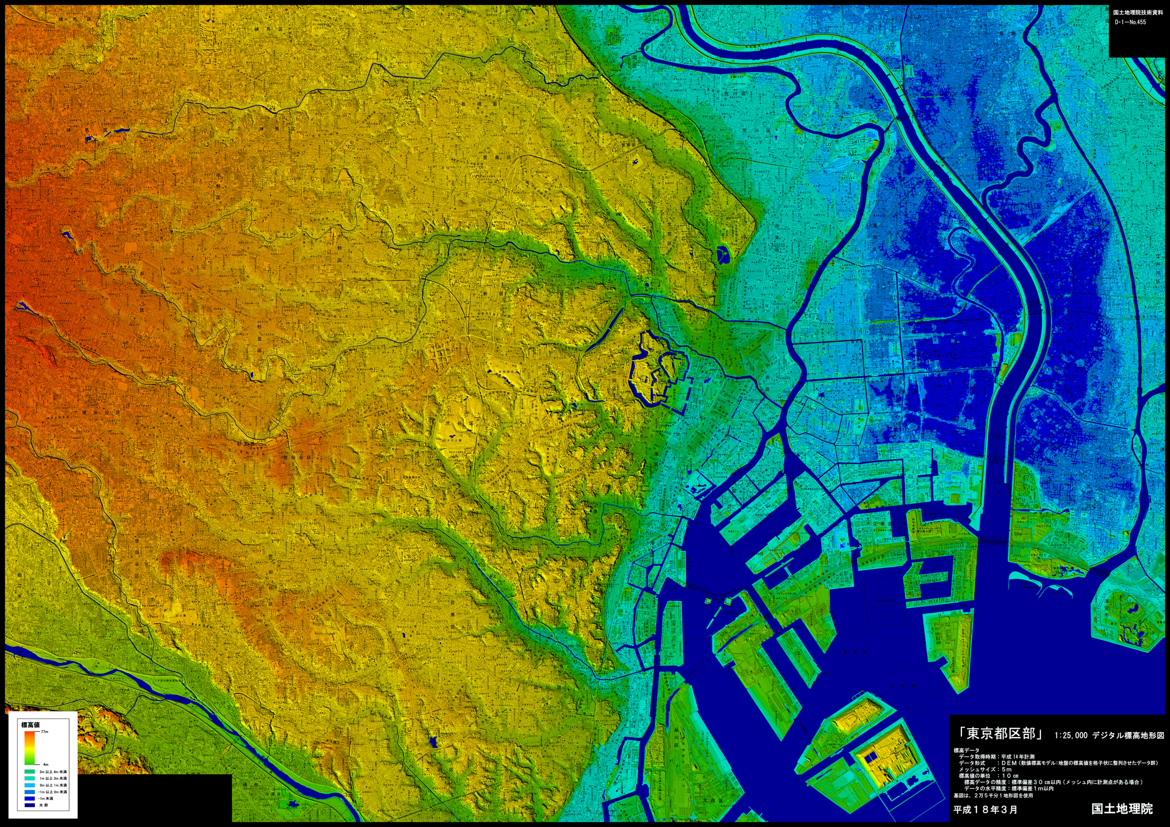
下図は、本年2022年1月21日投稿した「RM68 地名に潜むリスク 3(「干拓地」東京)」に引用した「国土地理院のホームページで公開されている『デジタル標高地形図』の『東京都区部』のページ」である。
The figure below is from the “Tokyo metropolitan area” page of the “Digital Elevation Topographic Map” available on the Geospatial Information Authority of Japan (GSI) website, which was quoted in the article “RM 68 A captive prepare for Risk in place names 3 (“Reclaimed land”, Tokyo)”posted on 21 January 2022.
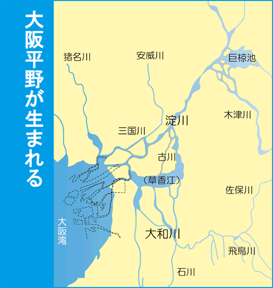
下図は、その国土地理院の「デジタル標高地形図」の「大阪」のページから引用したものである。
The following figure is quoted from the page of “Osaka” of the “Digital Elevation Topographic Map” of GSI.
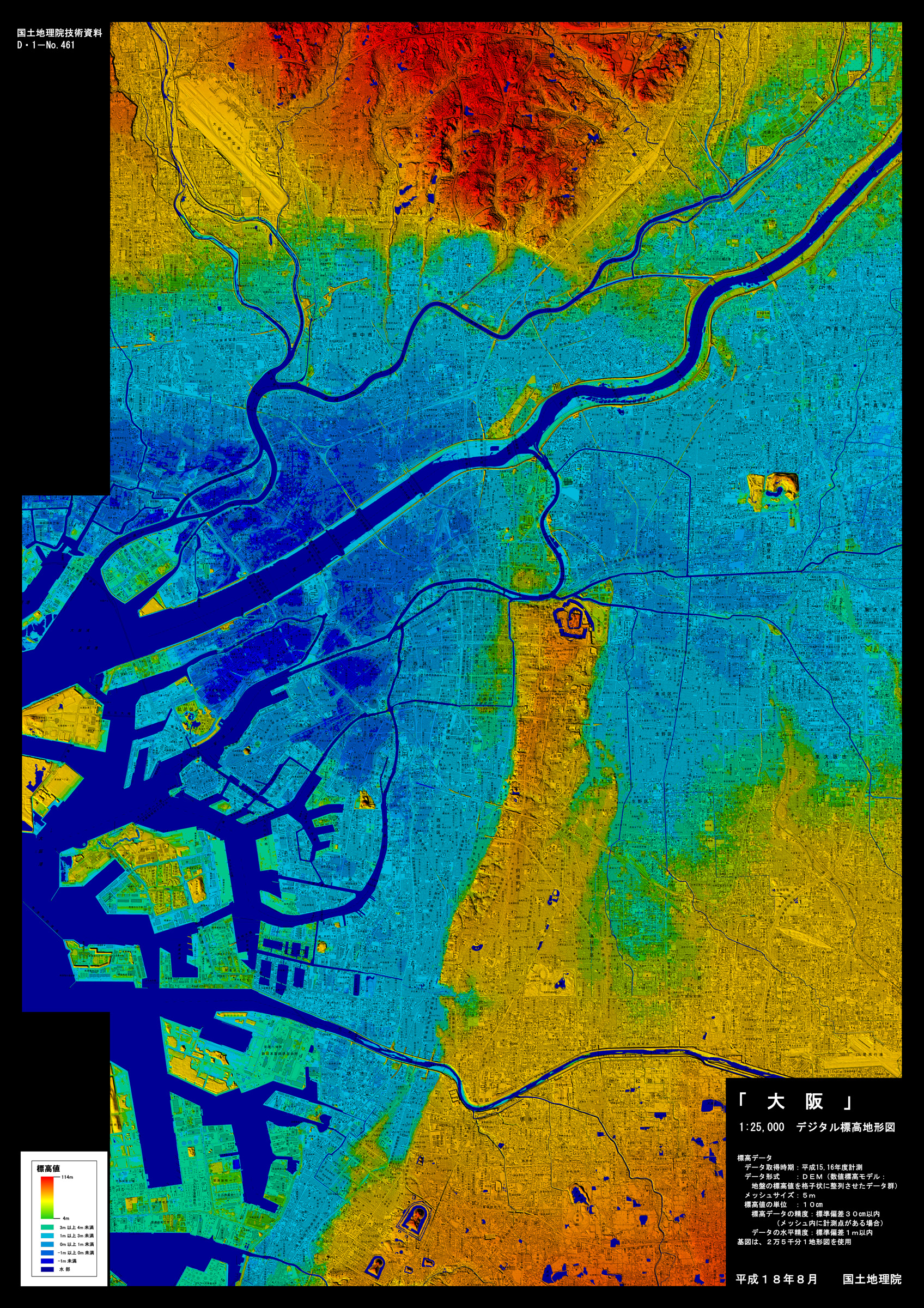
東京と大阪、この二つの「デジタル標高地形図」を比べて何を感じられるだろうか。
What do you feel when you compare these two “Digital Elevation Topographic Maps” of Tokyo and Osaka?
東京の旧「江戸城」(現「皇居」)、大阪の「大阪城」はいずれも高台、台地の上に築かれているのが解る。東京は旧「江戸城」から東側に標高の低い「水色」の一帯が広がっているが、大阪では「大阪城」が建てられている半島状の細長い台地以外ほとんどの場所が「水色」、そして「ゼロメートル地帯」を表わす「青色」である。
It can be seen that the former “Edo Castle” (the present “Imperial Palace”) in Tokyo and “Osaka Castle” in Osaka are both built on high ground or plateau. In Tokyo, there is a light blue area to the east of the old Edo Castle, but in Osaka, except for the long, narrow, peninsula-like plateau on which Osaka Castle is built, most of the area is light blue, and blue represents the “zero meter zone”.
1.「王将」
昭和を代表する作曲家「古関裕而」、彼の生涯を描いたTV番組がNHK「連続テレビ小説『エール』」として2020年前半期放送の予定であったが、新型コロナウイルスの感染拡大により大きな影響を受け、終了が2020年11月まで延期され、好評のうちに終了した。それから1年以上経つが、母校の応援歌がテーマの一つとなっていた所為か未だに番組のシーンを思い出すことがある。
そのなかで、「古関裕而が世に認められる曲」として描かれ、事実そうであった曲が、「早慶戦」では必ず歌われる早稲田大学の応援歌「紺碧の空」であった。1931年(昭和6年)、それまで早慶戦で立て続けに4連敗していた早稲田は、「慶応には『若き血』という応援歌があるから皆が元気になっている、だから勝っているのだ、早稲田も『若き血』を圧倒する応援歌をつくろう」と公募。早稲田大学文学部仏文科教授 西条八十の選考のもと選ばれた歌詞が『紺碧の空』であった。
『紺碧の空』を誕生させた西条八十は仏文科の教授でありながら、その後流行歌の作詞家としても名を馳せた。「戦後の厳しい時期に多くの人々が口ずさんだ」と言われている昭和歌謡の代表曲「青い山脈」、「無学でありながら卓抜した将棋の才を有した大坂の将棋棋士坂田三吉」をモデルにした「王将」等多くのヒット曲を書いた。その「王将」の歌詞は次のとおりである。
(1番)吹けば飛ぶような 将棋の駒に
賭けた命を 笑わば笑え
生まれ浪速の 八百八橋
月も知ってる おいらの意気
(2番)あの手この手の 思案を胸に
やぶれ長屋で 今年も暮れた
愚痴も言わずに 女房の小春
つくる笑顔が いじらしい
(3番)明日は東京に 出て行くからは
なにがなんでも 勝たねばならぬ
空に灯がつく 通天閣に
おれの闘志が また燃える
最愛の妻に先立たれた自身の妻への思い、それを坂田三吉に仮託して2番に「女房の小春」と投影させたのである。1961年、村田英雄が唄い150万枚を超える爆発的な大ヒットとなった。
2.八百八橋
江戸時代、大都市はその街を象徴する言葉で呼ばれていた。江戸は日本最大の街であり如何に街が大きいかを示す「江戸の八百八町」と呼ばれた。京都はお寺が多いため「京都の八百八寺」と。そして大阪は、上記「王将」の歌詞の1番にあるように「浪速の八百八橋」と呼ばれていた。無論、これらの言葉は、808ヶ所の町、寺、橋があるのではなく、それほど多くの寺や橋があるという比喩的な表現である。
大阪は、水運によって経済と文化の中心的都市として発展、“水都”と呼ばれていた。飛鳥時代には、大阪の港は「難波津」と呼ばれ、海外との交易拠点として栄えたが、江戸時代、大阪にあった橋は200程度で、江戸にあった橋は350を超えた。それにも関わらず、なぜ大阪が「八百八橋」と呼ばれていたのか、その背景には大阪が「商人の町」と呼ばれていたことに深く関係している。
「幕府直轄地であった大坂」であったが、幕府が架けた橋は200あまりの橋でわずかに12しかなかった。残りの橋は、全て商人たちが自らの生活、商売のために架けたものであった。「橋を誇りにする商人たちの橋建設に対する意欲」が、「商人の街、大阪」ゆえに「浪速の八百八橋」と言わしめたのではなかっただろうか。
東京の銀座と並んで日本を代表する高級ブランド街、大阪「心斎橋」、この「心斎橋」とは、運河の一つである「長堀川」にかつて架かっていた橋の名称であり、1622年、「長堀川」を開削した大商人の一人、「岡田心斎」が架けたと言われている橋である。
また、「重ね地図で愉しむ大阪『高低差』の秘密」(梅林秀行(監修)宝島社新書)には、「国を動かす『米』を握った商人がつくった『淀屋橋』」と題して「中之島から土佐堀川に架かる御堂筋の橋の名は『淀屋橋』。その名は無論、常安の屋号・淀屋から取られたもので、初代の橋は常安が架けた。」とある。幕府の許可を得て「中之島」に「米相場」を設立した常安は、橋の南側に2万坪あまりの土地を持っていて、中之島との行き来に架けた橋が「淀屋橋」であった。
3.縄文海進
旧石器時代は、最終氷期にあたり氷河が発達していたため海面が現在より著しく低かったが、その後の温暖化の時代は、日本では「縄文時代」、この温暖化によって溶け出した氷河が海水面を大きく押し上げた。関東地方でも、貝塚の分析から「群馬県邑楽郡板倉町付近」や「埼玉県さいたま市」付近まで海が入り込み、「東京湾が関東地方の奥まで進んだ」ことで、当時の東京湾は「奥東京湾」と呼ばれている。縄文時代のこの現象は、「海が内陸部に進む」ことから、「縄文海進」と呼ばれている。
この「縄文海進」によって、西日本でも大きな変動が起きていた。「瀬戸内海の出現」である。旧石器時代、海面は今よりも100m以上低く、日本は大陸と地続きであり瀬戸内海も陸地であった。しかし、「縄文海進」が進み、それまで平原であった土地に縄文時代に徐々に海水が入ってきて海が広がり現在の「瀬戸内海」が形成された。
(出典:「水都大坂ホームページ」「水都大阪の歴史」より)
(Source: “History of Osaka, the Aqua metropolis“, Sui-To Osaka Website)
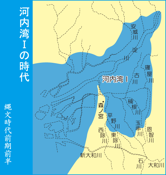
その頃の海岸線は、上図のとおり生駒山の麓、現在の東大阪市まで入り込んでいた。この湾は「河内湾」と呼ばれている。河内湾の入り口に森ノ宮から北に突き出ていた高地が「上町台地」である。
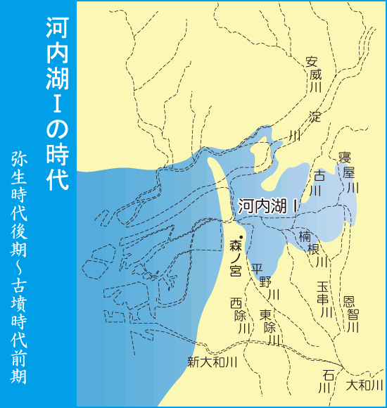
その後、「河内湾」の入り口は、安威川、淀川が運んできた土砂で埋まり砂州が形成されて、「河内湾」は海と切り離され「河内湖」が形成された。河内湖の突端まで行く間に港湾施設が建設された。これが「難波津」であり、海外交易の拠点であった。豊臣政権時代、江戸時代には縦横の河川と運河が整備され多くの橋が架けられた。
4.上町台地
上述のとおり、縄文時代から弥生時代にかけて大阪は、海岸線が平野部まで深く入り込み、その真ん中に「上町台地」が半島のように突き出していた。それが古墳時代になると、河内湾は海と切り離され、徐々に淡水化していき河内湖となっていった。
(出典:「水都大坂ホームページ」「水都大阪の歴史」より)
(Source: “History of Osaka, the Aqua metropolis“, Sui-To Osaka Website)
大和朝廷が、現在の奈良県明日香村、「飛鳥」の地に都を置いていた時代は、その地名に因んで「飛鳥時代」と呼ばれている。その飛鳥の地で645年に起きた「蘇我氏を滅ぼした政変」のことを、「大化の改新」と習ったが、今ではこの「クーデター」によって始まった一連の政治改革が「大化の改新」であり、「その政変には別の名称を用いるべきである」とされ、政変そのものは「乙巳(いっし)の変」と呼ばれている。
この後、飛鳥から大阪に遷都され、その都は「難波宮」と呼ばれている。後に東大寺大仏殿を建立した聖武天皇も、難波に遷都したことから、この「難波宮」は「前期難波宮」と呼ばれ、聖武天皇の「後期難波宮」と区別されている。
低地であった大阪平野は水害を受けやすい地形であったため、この「遷都」にともない「河内湖」の水域を減少させる大規模な治水工事や街並みの整備土木工事を行ない、徐々に「人々が住める土地」にしていった。この上町台地が臨む港は、「難波津」と呼ばれ、日本全国、また中国大陸や朝鮮半島との往来の拠点となって発展していった。
(出典:「水都大坂ホームページ」「水都大阪の歴史」より)
(Source: “History of Osaka, the Aqua metropolis“, Sui-To Osaka Website)
「上町台地」の突端に大阪城を築いた豊臣秀吉は、「大阪を日本の中心地にする構想」を案出、大規模な治水、土木工事に着手、大阪城の西方に外濠として「東横堀川」の掘削、街路整備をして、太閤下水を敷設、大阪中を「水の道」で結んでいった。また、堀川開削の許可を取り付けた商人たちも多くの掘削事業をおこなって、「水都大阪」ができあがっていった。
5.日本最大級の地震「宝永地震」
秀吉の時に「水都大阪」は誕生した。この全国の物流、商業の中心地であった大阪、先に記した「淀屋常安」は幕府の許可を得て、自らが開拓した大阪の「中之島」に「米相場」(米市)を開いた。全国の藩や米商人は米市に持ち込む米を貯蔵するため、米を貯蔵する蔵屋敷を中之島に建てた。その数は100を超え、市場で取引される全国の米の約4割がこの中之島の米市で取引きされていたと言われている。また、この米市でおこなわれた取引は「世界初の先物取引」とも言われている。
江戸時代、「重量物」を効率よく運搬する手段は「船」のみであった。そのための水運を円滑に進めるため、多くの「堀川」が更に掘削され、大阪中に縦横無尽に広がる「水路」ができあがっていった。「クレーン」など無い時代であり、「蔵」は荷物の荷下ろしに便利なように水辺にできるだけ高さを揃えて造られていった。
本年、2022年1月7日に投稿した「CA32『富士山噴火』に備えるキャプティブ」に記した、「南海トラフ沿いで東海、東南海、そして南海地震がほぼ同時に連鎖的に起きた、日本最大級の地震『宝永地震』」が1707年に起き、その「水都 大阪」を襲った。
一方、南海トラフの「真上」の四国の被害は甚大であった。高知城下では,「流された家1万1170戸,潰れた家1742戸,死人1844」を数え、太平洋沿岸の集落は大津波にいくつも流されている巨大地震が起きたのである。
「歴史から探る21世紀の巨大地震」(寒川 旭(著)朝日新書 朝日新聞出版(刊))には、そのときの大阪の様子が、次のように記されている。
元禄関東地震の余韻も醒めない1707年10月28日午後2時頃(宝永4年10月4日 未の刻)、関東から九州までの広い地域が大きく揺れた。大坂の市街地では、西南の方向からはじまって、天と地がひっくり返るほど激しく揺れ続け、西横堀・西南江戸堀・伏見堀・立売堀、 堀江北新地、心斎橋筋の北から南までの建屋が残らず潰れた(『諸国大地震津波一代記』など)。
もっと強い揺れが来るのを恐れた人びとは、家財道具を持って堀に浮かぶ船 に乗りこんだ。このとき、“ 船は、地震の揺れが少なくて安全”と思ったことが、大きな悲劇を招いている。地震の揺れから二時間近くたったころ、堀や川を遡った大津波が、河口に繫いでいた千石船などを浮かべながら、巨大な泥水の塊となって襲いかかったのである。水路に浮かんでいた小船は、大船の下敷きになり、ぶつかり合った船の間で人間の死骸が 浮き沈みした。(『諸国大地震津波一代記』など)。
今回のまとめ
本コラムを書きながら、10数年ほど前のことを思い出していた。「10年以上に渡り、毎年、年に6回のロンドン出張」をしていた頃である。「週末はどうするの?どこかに行くのか?」と友人に聞かれて、「何十回も来ているとどこにも行きたいところは無いな」と返したら、「イタリアに行ってみたら?ヨーロッパの発祥地の一つだし、面白いよ」と言うので、「え、イタリア、遠いよ」と言うと、「1時間半、2時間だよ』と笑いながら答えてきた。
調べてみると、確かに「『ロンドンーイタリア・ミラノ間』は飛行機で1時間半」ということが解った。「1時間半と言えば『東京ー沖縄』と同じか」とネットでホテルを予約、格安航空券を買って「席は先着順の飛行機」に飛び乗って、好きな絵を見にフィレンツェを訪れ、ウフィッツィ美術館に数度行った。しかし、いくら大きなウフィッツィ美術館と言っても数度も行けば十分堪能でき、「どこか次に」と思ってロンドンの友人に言うと、「ベネチアが良いよ、イカスミのパスタが最高」と、「ならば」とベネチアを訪れた。
イタリアの東端なので、「1時間半」という訳にはいかなかったが、それでも2時間ちょっとで着いた。電車を乗り継ぎベネチアへ。「さて、タクシー」と思ったら、目の前が「運河」、「カナル・グランデ(Canal Grande、大運河)」であった。「水の都」という意味がよく解った、ベネチア本島内はクルマは禁止で、すべて水上タクシーか、有名なゴンドラで移動する、移動手段は「徒歩」か「船」であった。
「ベネチア」は、北イタリア地方にいた人々が、5世紀頃東方から攻め込んで来るフン族からなどから退避するため「湿地帯である干潟」で暮らすようになったのがその発祥である。「干潟には大軍は攻めて来られないから」というのがその理由であった。
しかし、街が大きくなっていくにつれて「干潟のまま」では住居も不安定なので、大量の丸太の杭を打ち込み、それを建物の基礎としてその上に「土台」を築くようになった。無数の丸太が打ち込まれているので、「ベネチアが逆さまになると森になる」と言われている。建物も「重量制限」から高さを「3,4階まで」と制限して「軽く」していることもあり、地震の多いイタリアでもベネチアのビルは地震で倒壊したことはないが、「丸太の基礎」のため、地盤の沈下が進んでいて、訪れたときも「1階部分は居住空間になっていない建物」が散見された。
「物資、人を大量に高速で運搬、輸送することを可能にする鉄道、自動車」が生まれる前、その代わりとなっていたものは「船」であった。日本でも江戸時代まで「荷物を大量に高速で運搬する手段は船」しかなかった、つまり、その「運搬の道」である「海、川、そして運河」が生活に重要な役割を果たしていたのである。
しかし、「この便利な存在」は時として「リスクにもなり、それが大地震という事象を介すると非常に大きなリスクとして人々の生活に襲いかかってくること」が予見されることが解ってきた。しかし、その「リスクに対するリスクマネジメント」は十分機能しているとは言えない。
「RM68 地名に潜むリスクに備えるキャプティブ 3(「干拓地」東京)」で記した「表層地盤増幅率」(地震の揺れの強さは、その地盤が堅固かどうか、「表層地盤」(土地の表層近くの浅い部分)の揺れの大きさを数値化)を「地震ハザードステーション」の「地震ハザードカルテ」で大阪、梅田の中心「大阪駅」で「診断」してみたら次のような結果となった。地盤増幅率は2.1と「かなり揺れやすい」ことが解る。
表層地盤
地盤増幅率 2.1 微地形区分 三角州・海岸低地 30m平均S波速度 168m/s
ゆれやすさ全国上位3%
Ground amplification factor 2.1
Microtopography: Triangle, Coastal lowland
30m average S-wave velocity 168m/s
Top 3% of the country in terms of susceptibility to tremor
前述の「重ね地図で愉しむ大阪『高低差』の秘密」(梅林秀行(監修)宝島社新書)には次のような記述がある。
湿地帯が埋め立てられたのは江戸時代。「埋めてつくられた田んぼ」という意味から「埋田」と呼ばれた。「埋田」が「梅田」になるのは十七世紀後半。享保五年(千七百二〇)に初演がおこなわれた近松門左衛門の人形浄瑠璃「心中天網島」に「梅田橋」という橋が登場しているのが確認できる初出だ。
時代とともに、リスクは変化する。「効用をもたらすもの」が時として人に襲いかかる存在と化すことがある、それを見極めていくことを「リスクマネジメント」と呼ぶ。
「川・運河=効用」だけではなく、それが有する「リスク」も見極めていく必要がある。「平穏なとき」には素晴らしい水辺も、大地震が起きたらその場所は大きなリスクを孕む場所と化す。綺麗な海も、大地震によって大津波が起きれば人々に大損害を与え人々を苦しめる存在となる。なぜか、日本では、この当り前のことが理解されず「リスクマネジメント=保険=総務部の仕事」としか考えられていないことが多いように感じるのは筆者だけであろうか。
「キャプティブ」は、このリスクマネジメントを最高に進化、進展させた存在として評価されている。幸い、グローバル・リンクが設立、運営管理のコンサルティングをさせていただいてきた「キャプティブ」では、設立したその親会社でも経営トップが積極的にこのリスクマネジメント、キャプティブの運営に関与しておられる。「リスクマネジメント=キャプティブ=経営戦略」との理解が広がっていることは、これらの事業の末席に連なる筆者としても望外の喜びである。
「地名は歴史の語り部」であると筆者は考えている、是非自社の事業所、工場等の場所の謂われ、由来を調査してみることが必要ではないだろうか。それが「リスクマネジメントの第一歩」であるから。リスクが抽出され、特定されたら検証をおこない、「リスクマネジメントの究極の姿」である「キャプティブの設立」まで進まれることが重要ではないだろうか。
10年前、2012年8月、国の「有識者会議」が発表した、「南海トラフ巨大地震の被害想定」では、大阪府内では液状化だけで約1万6000棟が全壊すると指摘されている、「地震への対応待った無しだから」である。
執筆・翻訳者:羽谷 信一郎
English Translation
Risk Management (RM) 69 – Captives prepared for “Risk in place names” 4 (“Aqua metropolis”, Osaka)
1. “O-Sho(Shogi King)”
A TV program about the life of Yuji Koseki, one of the most famous composers of the Showa era, was scheduled to be broadcast in the first half of 2020 as NHK’s serial TV novel “Yale”, but it was postponed until November 2020 due to the spread of a new type of coronavirus.
In the program, the song which was depicted as “the song which made Yuji Koseki recognized by the public” was “Konpeki no sora (Azure Sky)”, the cheering song of Waseda University which is always sung in the “Waseda-Keio” game.
In 1931, Waseda University, which had been defeated four times in a row in the Waseda-Keio game, invited the public and said, “Keio has a cheering song called ‘Wakakichi’, which makes everyone cheerful, and that is why we are winning. Yaso Saijo, a professor of French literature at the Faculty of Letters, Waseda University, selected the lyrics of “Konpeki no sora (Azure Sky)”.
He wrote a number of hit songs, including “Aoi Samyaku(Blue Mountains)”, one of the most popular songs of the Showa era (1926-1989), which is said to have been sung by many people during the difficult post-war period, and “O-sho”, which is based on the story of Sankichi Sakata, an uneducated but brilliant shogi player from Osaka. The lyrics of “O-sho” are as follows.
(No.1) To a piece of shogi that can fly if blown away
Laugh if you laugh at the life you bet on
Born in Naniwa no Hapaykuya-bashi
The moon also knows my spirit
(No.2) With all my plans in mind
This year has come to an end in a shabby tenement
Without complaining, my wife, Koharu
The smile she makes is so sweet
(No.3)Tomorrow I’m leaving for Tokyo
I have to win at all costs
The sky is lit up by the Tsutenkaku Tower
My fighting spirit burns again
In the second verse of the song, he projected his feelings for his wife, who had passed away, onto Sankichi Sakata. In 1961, Hideo Murata sang this song and it became an explosive hit, selling over 1.5 million copies.
2. Happyakuya-bashi ( Eight hundred and eight bridges )
In the Edo period (1603-1868), large cities were called by words that symbolised the city. Edo was the largest city in Japan and was called “Happyakuya (eight hundred and eight towns) of Edo” to show how big the city was. Kyoto, with its many temples, was called “Kyoto no Happyakuya-ji” (Kyoto’s eight hundred and eight temples). And Osaka was called “Naniwa no Happyakuya-bashi” (Eight hundred and eight bridges in Naniwa), as the first verse of “O-sho” says. Of course, these words are metaphorical expressions for the fact that there are not 808 towns, temples and bridges, but so many temples and bridges.
Osaka developed as an economic and cultural centre thanks to water transport, and was called the “Aqua metropolis “. In the Asuka period, Osaka’s port was called “Naniwa-zu” and prospered as a base for trading with foreign countries, but in the Edo period (1603-1868), there were only about 200 bridges in Osaka and more than 350 in Edo. The reason why Osaka was called “Happyakuya-bashi” is deeply related to the fact that Osaka was called ” the merchant town “.
Although Osaka was under the direct control of the Shogunate, the Shogunate built only 12 of the 200 or so bridges. The rest of the bridges were built by merchants for their own livelihood and business. The merchants were so proud of their bridges that they were willing to build them, which is why Osaka, the city of merchants, was called “Naniwa’s Happyakuya- bashi (eight hundred and eight bridges)”.
Osaka’s Shinsaibashi was one of Japan’s leading luxury brand districts, along with Tokyo’s Ginza. It is said that Okada Shinsai, one of the great merchants who opened the Nagahori River in 1622, built this bridge over the Nagahori River, one of the canals in the Edo period. In addition, in a book titled “The Secret of Osaka’s ‘High and Low Difference’ Enjoyed with Overlapping Maps” (supervised by Hideyuki Umebayashi, published by Takarajimasya Shinsho), there is an article titled “Yodoyabashi, the bridge built by the merchant who held the “‘rice that moves the country,” which says, “The name of the bridge on Midosuji Avenue from Nakanoshima to Tosabori River is “Yodoyabashi”. The name was, of course, taken from Jyoan’s business name, ” Yodoya,” and the first bridge was built by Jyoan, who had established a rice market in Nakanoshima with the permission of the Shogunate, had a plot of land of about 20,000 tsubo on the south side of the bridge, and the bridge he built to get to and from Nakanoshima was called Yodoyabashi.
3. Jomon transgression
The Paleolithic period was the last glacial period, when the sea level was significantly lower than it is today due to the development of glaciers, but the subsequent period of warming was the Jomon period in Japan. The glaciers that melted as a result of the warming pushed the sea level up significantly. Even in the Kanto region, analysis of shell mounds shows that the sea entered the area around “Itakura-cho, Oura-gun, Gunma Prefecture” and “Saitama City, Saitama Prefecture”, and “Tokyo Bay advanced to the far end of the Kanto region”, which is why Tokyo Bay at that time is called “Oku-tokyo Bay”. This phenomenon in the Jomon period is called “Jomon Kaishin(transgression)” because the sea moved inland.
As a result of this “Jomon transgression”, a major change also occurred in western Japan. This was the emergence of the Seto Inland Sea. During the Paleolithic period, sea level was more than 100m lower than it is today, and Japan was connected to the continent by land. During the Jomon period, however, the seawater gradually entered the land that had previously been a plain, expanding the sea and forming the Seto Inland Sea as we know it today.
At that time, as shown in the diagram above, the coastline extended from the foot of Mount Ikoma to present-day Higashi Osaka City. This bay is called “Kawachi Bay”. The Uemachi plateau is the highland that juts out from Morinomiya to the north at the entrance to Kawachi Bay.
Later, the entrance to Kawachi Bay was filled in with earth and sand brought in by the Aigawa and Yodo Rivers, forming a sand bar, separating Kawachi Bay from the sea and forming Lake Kawachi. On the way to the end of Lake Kawachi, a port facility was built, which was called Naniwazu, and was a base for overseas trade. During the reign of Toyotomi and the Edo period (1603-1868), rivers and canals were constructed and many bridges were built.
4. Uemachi Plateau
As mentioned above, from the Jomon to the Yayoi period, the coastline of Osaka penetrated deep into the plain, and the Uemachi plateau jutted out like a peninsula in the middle. In the Kofun period, Kawachi Bay was separated from the sea and gradually became fresh water, becoming Lake Kawachi.
The Yamato Court had its capital at Asuka, in present-day Asuka Village, Nara Prefecture, in a period known as the Asuka Period, after the name of the place. However, it is now believed that the series of political reforms initiated by this coup d’état was the “Taika-no-Kaishin” and that “the political change should be called by a different name”. The political change itself was called the “Isshi Incident”.
After this, the capital was moved from Asuka to Osaka, where it was called Naniwanomiya. Later, Emperor Shomu, who built the Great Buddha Hall at Todaiji Temple, moved the capital to Naniwanomiya, which is why it is called the Early Naniwanomiya and distinguished from the Late Naniwanomiya of Emperor Shomu. The lowland Osaka plain was prone to flooding, so with the relocation of the capital, large-scale flood control work was carried out to reduce the area of Lake Kawachi, and civil engineering work was carried out to improve the townscape, gradually making it a land where people could live. The port overlooking the Uemachi plateau was called “Naniwazu” and developed into a hub for traffic to and from all over Japan, as well as the Chinese continent and the Korean peninsula.
Hideyoshi Toyotomi, who built Osaka Castle at the top of the Uemachi Plateau, conceived the idea of making Osaka the centre of Japan and embarked on large-scale flood control and civil engineering work, including the excavation of the Higashiyokobori River as an outer moat to the west of Osaka Castle, the construction of streets, and the laying of the Taikoh sewage system. Merchants who obtained permission to excavate the Horikawa River also carried out many excavation projects, thus creating the ” Aqua Metropolis of Osaka”.
5. The Hōei Earthquake, one of the largest earthquakes in Japan
At the time of Hideyoshi’s reign, the aqua metropolis of Osaka was born, and it was here that Jyoan Yodoya, with the permission of the Shogunate, opened a rice market on the island of Nakanoshima, which he had cultivated. Clans and rice merchants from all over the country built warehouses on Nakanoshima to store the rice they brought to the rice market. It is said that more than 100 of these warehouses were built, and about 40% of the rice traded on the market was sold at the Nakanoshima rice market. The rice market is said to have been the world’s first futures market.
In the Edo period, the only efficient means of transporting heavy goods was by boat. In order to facilitate the transportation of goods by water, a number of moats were excavated, creating a network of waterways that stretched in all directions throughout Osaka. In those days there were no cranes, and the warehouses were built as close as possible to the water’s edge, at the same height as possible, to make it easier to unload goods.
This year, as I wrote in “CA (Captive) 32 – Captives prepare for Mt Fuji eruption” posted on January 7, 2022, one of Japan’s largest earthquakes, the 1707 Hōei Earthquake, which caused the Tokai, Tonankai and Nankai earthquakes to occur almost simultaneously in a chain reaction along the Nankai Trough, struck the Aqua Metropolis. The damage to Shikoku, which lies directly above the Nankai Trough, was devastating. In the area around Kochi Castle, “11,170 houses were washed away, 1,742 houses were destroyed, and 1,844 people died”, and many villages along the Pacific coast were swept away by the tsunami.
In a book titled “Giant Earthquakes in the 21st Century from History,” (Akira Sangawa (Author) Asahi Shimbun Shuppan (Asahi Shimbun Publishing Co., Ltd.)), describes the situation in Osaka at that time as follows.
At around 2:00 p.m. on October 28, 1707, still in the aftermath of the Genroku Kanto Earthquake, a large area from the Kanto region to Kyushu shook violently. In the city of Osaka, starting from the southwest, the quake shook so violently that the earth and sky were turned upside down, and every building from north to south in Nishiyokobori, Seinan Edobori, Fushimibori, Itachibori, Horie Kitashinchi, and Shinsaibashisuji was destroyed (“Shokoku Daijishin-tsunami Ichidai-ki”, etc.).
Fearing a stronger tremor, people took their belongings and boarded boats floating on the moat. Thinking that the boat would be safer because it would not be shaken by the earthquake, this led to a great tragedy. Nearly two hours after the quake, a massive tsunami swept up the moat and river, turning the mooring into a huge mass of muddy water that floated along the river’s mouth. Small boats floating in the channel were swamped by the larger ones, and human carcasses floated and sank between the colliding boats.(The Chronicles of the “Shokoku Daijishin-tsunami Ichidai-ki”, etc.).
Summary of this issue
While writing this column, I was reminded of something that happened more than ten years ago, about a dozen years already. At that time, I was “travelling to London six times a year, every year, for more than ten years”. ‘What do you do at weekends? Do you go anywhere?”And my friends would ask me. I replied, “I’ve been here dozens of times and there’s nowhere I’d rather be”, to which he replied, “Why don’t you go to Italy? It’s one of the birthplaces of Europe and it’s interesting.” I said, “Well, Italy is far away,” and he replied with a laugh, “It’s only an hour and a half or two hours.
When I looked it up, I found out that “London to Milan, Italy” is indeed one and a half hours by plane. So I booked a hotel on the internet, bought a cheap ticket, jumped on the plane, visited Florence to see my favourite paintings and went to the Uffizi Gallery several times. However, no matter how big the Uffizi Gallery was, I could enjoy it enough after visiting it several times, and when I said to my friend in London that I wanted to go somewhere else, he said “Venice is good, the pasta with squid meat is the best”, so I decided to visit Venice.
Since Venice is in the eastern end of Italy, it was not an “hour and a half” trip, but it still took a little over two hours. I took a train to Venice. I took a train to Venice, and when I took a taxi, I found myself in front of a canal, the Canal Grande. Cars are not allowed on the main island of Venice, and all transportation is by water taxi or the famous gondola, either by foot or by boat.
Venice was founded in the 5th century by the people of northern Italy, who lived in the marshy mudflats to escape the Huns who invaded from the east. The reason for this was that “a large army could not attack on the mudflats”. However, as the town grew, the houses were not stable “on the mudflats”, so a large number of log piles were driven into the ground to form a foundation on which the buildings were built. So many logs were driven that it is said that “Venice, turned upside down, is a forest”. Because of the weight limitation, the height of the buildings is limited to three or four stories, and the buildings in Venice are made light, so that even in earthquake-prone Italy, no building in Venice has collapsed in an earthquake. There were also buildings with no habitable space on the ground floor.
Before the birth of the railway and the automobile, which made it possible to transport goods and people in large numbers at high speed, the alternative was the ship. Until the Edo period (1603-1868), the only means of transporting goods in large quantities at high speed in Japan was by boat, and the sea, rivers and canals played an important role in the life of the country. However, it has become clear that “this convenient existence” can sometimes become “a risk, and when it comes through a major earthquake, it can be a very big risk to people’s lives”. However, “risk management for risk” is not functioning well.
The “surface ground amplification ratio” (the strength of an earthquake is quantified by the strength of the shaking of the “surface ground” (the shallow part of the land near the surface)), which was described in “RM68 A captive prepare for “Risk in place names” 3” (reclaimed land, Tokyo), was checked at Osaka Station, the centre of Umeda, Osaka, using the “earthquake hazard chart” of the “Earthquake Hazard Station”, and the results were as follows.
Surface ground
Ground amplification factor 2.1
Microtopography: Triangle, Coastal lowland
30m average S-wave velocity 168m/s
Top 3% of the country in terms of susceptibility to tremor
The aforementioned “The Secret of Osaka’s ‘Height Difference’ Enjoyed with Overlapping Maps” (Hideyuki Umebayashi (supervisor), Takarajimasha Shinsho) has the following description.
The wetlands were reclaimed in the Edo period. It was called ” Umeda”, meaning “rice field made by filling up”. It was in the latter half of the 17th century that the name “Ume(fill) da” was changed to “Ume(plum)da”. A bridge called Umeda-bashi first appears in the ningyo joruri (puppet play) Shinju Tenamishima by Monzaemon Chikamatsu, which was first performed in Kyoho 5 (1720).
Over time, risks have changed. Risk management is the art of recognising when something that brings utility has become an assault on humanity. It is necessary to identify not only the benefits of rivers and canals, but also the risks they carry. A waterfront that looks great when it is “calm” becomes a place of great risk when a major earthquake strikes. A beautiful sea can be a place of great damage and suffering when an earthquake causes a tsunami. For some reason, in Japan, people do not understand this fact, and often think that risk management = insurance = work of the general affairs department.
Captives are regarded as the best evolution and development of risk management. Fortunately, in the captives that Global Link has established and consulted on the management of, the top management of the parent company has been actively involved in the risk management and operation of the captive. It is my great pleasure to see that the understanding of the concept of “risk management = captive = management strategy” is spreading.
The author believes that “place names are historical narratives” and that it is necessary to investigate the origins of places of business and factories. This is the first step in risk management. Once the risks have been identified and verified, it is important to proceed to the “establishment of a captive”, which is the “ultimate form of risk management”.
Ten years ago, in August 2012, an expert panel of the Japanese government issued a report on the potential damage caused by a massive earthquake in the Nankai Trough. The report pointed out that about 16,000 houses in Osaka Prefecture could be completely destroyed by liquefaction alone.
Author/translator: Shinichiro Hatani