
キャプティブ 2023.01.30
CA47 海外の大地震は日本に影響を与えないのか?(キャプティブの必要性)
目次
Copyright © Shinichiro Hatani 2023 All rights reserved
For those who prefer to read this column in English, the Japanese text is followed by a British English translation, so please scroll down to the bottom of the Japanese text.
本年2023年1月18日、一般財団法人日本気象協会が運営している天気予報を提供するウェブサイト「tenki.jp」で、以下が報道された。
18日15時06分ころ、海外で規模の大きな地震がありました。この地震により、日本の沿岸では若干の海面変動があるかもしれませんが、被害の心配はありません。震源の近傍で津波発生の可能性があります。気象庁では18日15時20分に北西太平洋津波情報を発表しています。
この、海外の「規模の大きな地震」とは、フィリピンの南にある、インドネシア中部のモルッカ海を震源とするマグニチュード(M)7.2の地震のことである。筆者はこのニュースを見て「南海トラフ巨大地震」の引き金にならなければいいが」と不安な気持ちに駆られた。
なぜ、インドネシアの地震が南海トラフ巨大地震の引き金になる懸念を持ったのか、それは下図を見るとその意味が分かるであろう。
(出典:USGS, Washiucho) (Source: USGS, Washiucho)
これは、最新の地球物理学で示されている、「地球の表層部を覆っている『プレート』」を記した地図である。今回マグニチュード7.2の大地震が起きた「モルッカ海」は「フィリピン海プレートの最南端の尖った場所周辺の海域のこと」を言い、そしてこのフィリピン海プレートが、この図の上部で日本列島と接している場所こそが「南海トラフ」と言われる場所だからである。
つまり、このマグニチュード7.2の大地震は、南海トラフが存在するフィリピン海プレートの反対側で起きた大地震であり、そしてその影響はプレート全体に少なからず波及することが予測できるからである。
しかし、日本での報道は「海外で規模の大きな地震がありました。この地震により、日本の沿岸では若干の海面変動があるかもしれませんが、被害の心配はありません。」となっているのである。
家庭にある「テーブルの片一方に、ある力が加われば、そのエネルギーは同じテーブルに乗っているあらゆる食器に影響を与えること」は自明の理であるが、なぜか「地球規模のテーブル」である「プレート」ではこのことは省みられていないようである。
筆者が大きな地震リスクへの対策として早急な「キャプティブの設立」を声高に言い続けている理由の背景はここにある。
1.プレート
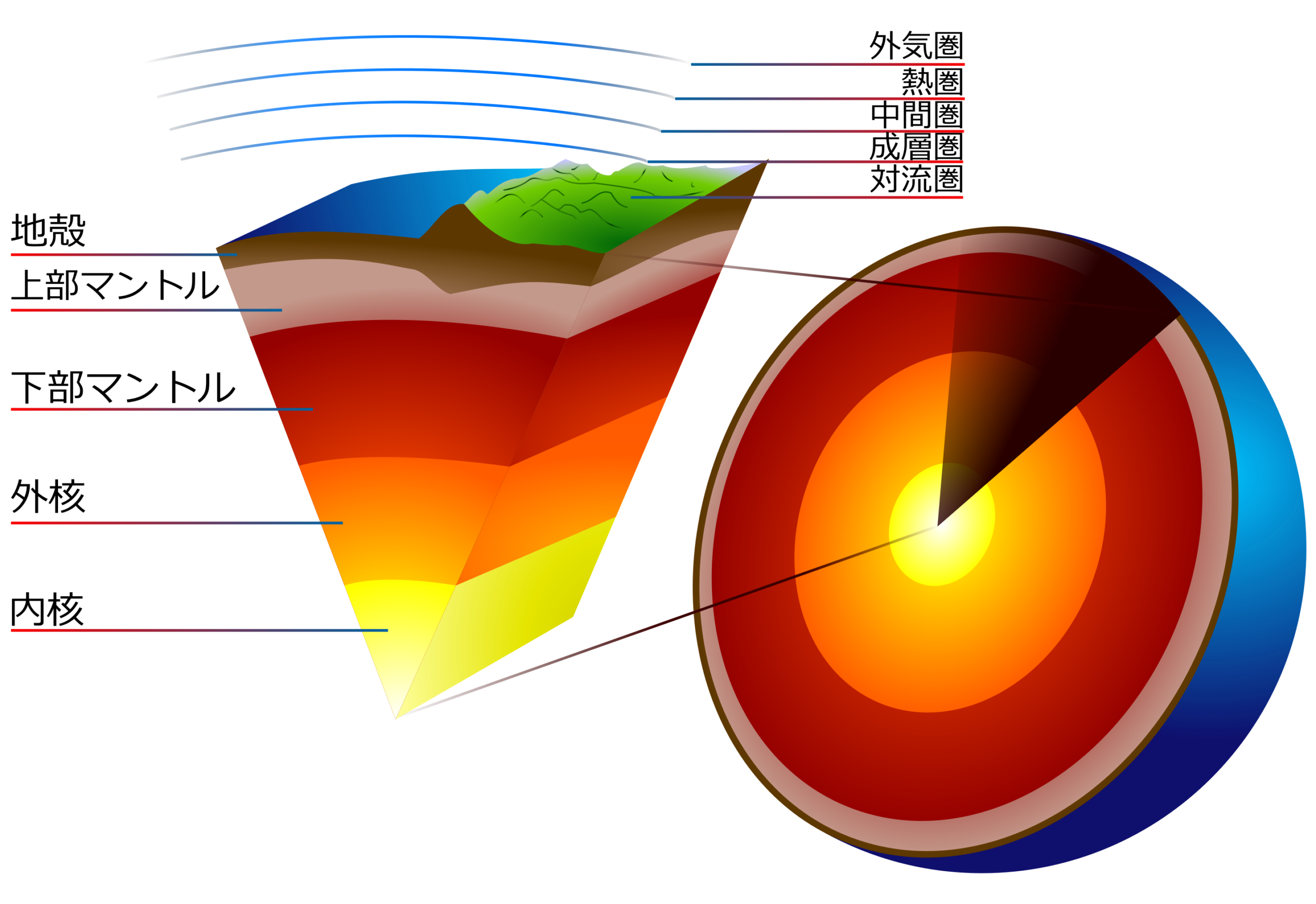
地球は、半熟卵に例えられることが多い。中心が「核」、そしてそれを覆う「マントル」、さらに地球の表面が「地殻」である。「核」の主成分は鉄で、温度は約6000℃とされている。マントルは岩石とされているが、核に接する部分が核の高温のため柔らかい「マグマ(溶岩)」となっている。そしてこの温度差で発生するのが「マントルの対流」という現象である。高温のマグマが対流して上ってきてそれが火山の下に溜まる、その場所を「マグマ溜り」と言い、このマグマが火山の噴火によって「溶岩、火砕流」等となって外に排出されるのである。
この「マグマ」を覆う、固い岩石部分が「プレート」と呼ばれているものである。その表面を覆っている最上部が「地殻」と呼ばれ、海や陸地が乗っている部分である。
(出典:Earth-crust-cutaway-Japanese.svg) (Source: Earth-crust-cutaway-Japanese. svg)
現在の地球物理学の定説では、3億年前、地球上には、「パンゲア」と呼ばれる1つの大陸しか無かった、それが、2億年前に分裂を始めたとされている。その後、更なる分裂によって、プレートは10数枚となったが、当然その移動に応じて、上に乗った陸地も同じく移動している。ハワイは、1年間に約8cmずつ日本に近づいていると言われているが、このプレートが移動するという理論を「プレートテクトニクス(プレート理論)」といい、「キャプティブが最高のソリューション(解決策)と評されている『大地震』、その発生の有力な理論的裏付けとなっている理論」である。
20世紀始め、「地図」だけを頼りにこの「プレートテクトニクス理論(大陸移動説)」の萌芽を提唱した人物が、ドイツの気象学者「アルフレート・ヴェーゲナー」である。彼は「世界地図を見ていて、南大西洋を挟んで、南アメリカ大陸の海岸線とアフリカ大陸の海岸線がよく似ていることに気づき、これが大陸移動説を生み出すアイデアになった」とその著作で述べ、 1912年フランクフルトで開かれたドイツ地質学会で初めてこの「大陸移動説」を発表したのである。
プレートに乗った大陸が衝突することも起きる。オーストラリア沖に存在したインド大陸が移動してユーラシアプレートに衝突した。その衝突の衝撃で大地に皺が誕生して発生したのが「ヒマラヤ山脈」であった。島であった「伊豆半島」が日本列島に衝突して合体して誕生したのも同じである。
ただ、「プレートは地球の表面を移動し続ける」のではなく、プレートを構成する原料のマグマは、海底火山から生み出され凝固してプレートを形作っていく。そして、そのプレートは移動して深海の海溝深くに沈み込んでいって消失する、これが「プレートの一生」である。
プレートには「大陸プレート」と「海洋プレート」がある。海洋プレートは、大陸プレートよりも強固で密度が高いため、2つのプレートが衝突すると海洋プレートは大陸プレートの下に沈んでいく。上図のように、この「大規模プレート」は14~15枚あるとされているが、1つのプレート内で移動速度が異なる部分があることが発見され、理論に適合せず不自然となるため考え出された新たな理論が、小規模な40数枚の「小規模プレート」が存在するというものである。
2.フィリピン海プレート
フィリピン海プレートは、冒頭の図のとおり、太平洋プレートと接する場所は、東側は小笠原海溝、マリアナ海溝その北は日本海溝、ユーラシアプレートと接する西側は、南海トラフ、琉球海溝、フィリピン海溝、これらに囲まれた小さな海洋プレートである。
フィリピン海プレートがユーラシアプレートに沈み込む日本列島の和歌山沖から九州宮崎沖までの一帯が南海トラフと言われる場所であり、懸念されている海溝型巨大地震、「南海トラフ巨大地震」の震源と目されている場所である。また、1923年発生した関東大震災も、フィリピン海プレートが北アメリカプレートに沈み込むことによって発生した地震である。
冒頭の図に明らかなとおり、関東地方は北アメリカプレートに、フィリピン海プレート、太平洋プレート、この2つのプレートが沈み込む場所であり、そのため「大きな海溝型(プレート型)地震のリスクがある場所」である。プレートは時々刻々と動いている、小さな沈み込みの動きであっても地球規模のプレートが動く以上、地上には大きな影響、そのほとんどが「大地震」となって現れる。
「伊豆半島の合体活動」は現在でも続いている、その延長線上にある巨大な活火山が富士山である。富士山のマグマ溜まりに影響を与えないはずがない、富士山噴火の危険性は伊豆半島の動きと連動して高まっているのである。
3.フィリピン海プレート周辺の地震
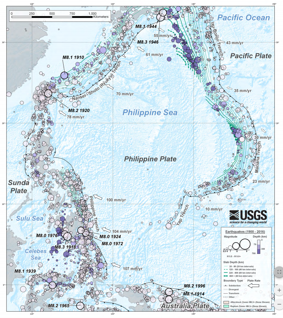
(出典:USGS) (Source: USGS)
上図は、米国内務省傘下の調査機関の一つ、1879年に設立された米国地質調査所(United States Geological Survey: USGS)が公開している、「1900年から2016年に掛けてフィリピン海プレート周辺で発生したマグニチュード(M)5.5以上の地震を記した図」である。北部(図の上部)に日本列島が見えるが、このフィリピン海プレートが他のプレートと接する場所で大きな地震が発生しているのが一目瞭然である。
日本列島周辺に記された「M8.1 1944」とは1944年12月7日発生した「昭和東南海地震」であり、「太平洋戦争中で、報道管制が引かれ『隠された』と言われているマグニチュード8.1の大地震」のことである。「南海トラフ巨大地震」の予測震源域の東半分一帯、駿河トラフと南海トラフ沿いを震源とする地震であった。
この半年前、米軍はサイパン島などマリアナ諸島を制圧、日本本土空襲の基地として活用し始めて、これ以降本格的な日本本土への空襲が始まった。その最中の大地震であった。当時の地震観測網でも地球の反対側で起きた地震でさえ、その震源、震域、規模、被害等を特定することは可能であったにも関わらず、「敵を利する」と日本政府は必死になってこの「昭和東南海地震」発生のニュースを隠蔽、報道管制が敷かれ日本のどの新聞にも詳しく掲載されていなかった。
しかし、地震の震源地、被害状況は、翌日12月8日付「ニューヨーク・タイムズ」には具に掲載されていたのである。また、「M8.3 1946」とは、終戦後の混乱のなか和歌山県沖を震源として1946年12月21日に発生したマグニチュード8.3の巨大地震、「昭和南海地震」のことである。
気象庁のホームページには、「南海トラフ地震」について次のとおり記されている。
南海トラフ地震は、駿河湾から日向灘沖にかけてのプレート境界を震源域として概ね100~150年間隔で繰り返し発生してきた大規模地震です。前回の南海トラフ地震(昭和東南海地震(1944年)及び昭和南海地震(1946年))が発生してから70年以上が経過した現在では、次の南海トラフ地震発生の切迫性が高まってきています
今回のまとめ
家庭にある「テーブル」を例に挙げる。家族4人で座って食事をしている時、急に父親がテーブルにドンと手を突いて立ち上がるとテーブル上のモノに何が起きるか。頑丈なテーブルであれば多少の振動が他の家族の方にあるぐらいだが、もしそのテーブルが「柔らかな素材で来たテーブル」であればどうだろうか。他の家族が座っている前のテーブルはその影響で大きく持ち上がることになる。
プレートは表面は頑丈な岩石で構成されているがそのプレートが乗っている土台は「マグマ=液状化した柔らかい岩石」である。こういうことからも、「インドネシアの大地震は確実に日本列島にも影響を与える」ということが予測できる。それを上のUSGSの「フィリピン海プレート周辺で発生したマグニチュード(M)5.5以上の地震を記した図」は暗示しているのではないだろうか。
懸念されている南海トラフ地震の想定震源域は、3つに分かれている。静岡地方を想定震源域とする地震が「東海地震」であり、愛知、三重、和歌山を想定する地震が「東南海地震」、その以西宮崎沖まで伸びる想定震源域を持つ地震が「南海地震」である。時間差があっても、前述のとおり、これら3つの震源域が連動する可能性が高いと言われており、「東日本大震災を遙かに凌ぐ、超巨大震災になる」と予測されている。
グローバル・リンクは、「地震リスクへの対応を主目的とするキャプティブ」の設立を推奨し続けてきた。その理由は、地震リスク以外の大半のリスクであれば、世界的にも評価の高い日本の損害保険会社であれば相応の保険料で十分に補償できる。
しかし、地震リスクは、日本の損害保険会社の引受力(キャパシティ)では、企業が求める補償を十分に受けることは非常に困難である。また、そのコスト(保険料)はかなりのレベルとなり、「キャプティブを設立して世界的規模を有する信用のおける海外の再保険会社から引受力(キャパシティ)を得た方が、遙かに廉価な保険料で、遙かに大きな金額の地震リスクの補償を受けることができるから」である。
しかし、リスクマネジメントに先進的な一部の企業を除いて、政府が巨大地震に関する切迫した情報を幾度となく発表しても、また富士山噴火の可能性に関する報道が度々なされても、キャプティブを活用してリスクマネジメントに積極的に取り組もうとする企業の数は、欧米のそれと比べると遙かに少ない。
キャプティブの設立までには、通常数ヶ月以上掛かるという現実がある。大地震が起きてから、「やっておけば良かった」と後悔しないためにも、一刻も早く取り組むことが肝要ではないかと感じている。
2011年3月11日の東日本大震災から12年目の日をもうすぐ迎える今、また「想定外」との言葉を発することはできない。ステークホルダーへの責務を果たす役割を担うのが経営陣であるからである。その「参謀役」の部門が果たさなければならない喫緊の責務は「巨大地震リスクへの対応」と筆者は考える。
日本の損害保険会社のキャパシティ(保険引受力)では巨大地震への対応が十分ではないことは広く知られている、今こそキャプティブの設立によって海外の巨大再保険会社のキャパシティ(保険引受力)を得る時であると言えるのではないだろうか。
執筆・翻訳者:羽谷 信一郎
English Translation
Captive (CA)47 Will major earthquakes abroad affect Japan? (Need for captives)
The following was reported on 18 January 2023 on tenki.jp, a website providing weather forecasts operated by the Japan Weather Association.
At around 15:06 on 18 January, there was an earthquake of a large scale overseas. The earthquake may cause some sea level fluctuations along the coast of Japan, but there is no danger of damage. There is a possibility of tsunami generation in the vicinity of the epicentre. The Japan Meteorological Agency has issued a Northwest Pacific Tsunami Information at 15:20 on 18 June.
This overseas “earthquake of major magnitude” refers to a magnitude (M) 7.2 earthquake with its epicentre in the Molucca Sea in central Indonesia, south of the Philippines. The author was driven to anxiety by this news, hoping that it would not trigger a “Nankai Trough mega earthquake”.
The following diagram will help to explain why I was concerned that the Indonesian earthquake could trigger a Nankai Trough mega earthquake.
This is a map showing “the ‘plates’ covering the surface of the Earth” as indicated by the latest geophysics. The Molucca Sea, where the magnitude 7.2 earthquake occurred, is “the sea area around the southernmost tip of the Philippine Sea Plate”, and the place where the Philippine Sea Plate meets the Japanese Islands at the top is known as the “Nankai Trough”.
In other words, the magnitude 7.2 earthquake was a major earthquake on the opposite side of the Philippine Sea Plate, where the Nankai Trough exists on the same plate, and its effects can be expected to spread to the entire plate in no small degree.
However, media reports in Japan are saying: “There was a major earthquake overseas. The earthquake may cause some sea level changes along the Japanese coast, but there is no danger of damage.” This is the same as the following. It is self-evident that “if a force is applied to one side of the table, the energy will affect all the dishes on the same table” in the home, but for some reason this seems to be neglected in the “global table”, the “plates”.
This is the reason why the author has been vocal about the urgent establishment of captives as a countermeasure against major earthquake risks.
1. plates
The Earth is often compared to a half-cooked egg. The centre is the “core”, the mantle covers it, and the surface of the Earth is the crust. The “core” is mainly made up of iron and is said to be at a temperature of about 6000°C. The mantle is considered to be rock, but the area in contact with the core is soft magma (lava) due to the high temperature of the core. This temperature difference causes a phenomenon called “mantle convection”. The hot magma convects up and accumulates beneath the volcano, where it is called the “magma reservoir” and is ejected outwards by the volcanic eruption.
The solid rock covering the magma is called a “plate”. The uppermost part covering the surface is called the “crust” and is the area on which the oceans and land are located.
According to current geophysical theory, 300 million years ago, there was only one continent on Earth, called “Pangaea”. It is believed that this began to break up 200 million years ago. Subsequent further break-up has resulted in more than a dozen plates, and naturally, the land masses on top of them have moved as well. Hawaii is said to be moving closer to Japan by about 8 cm per year. This theory of plate movement is called “plate tectonics (plate theory)” and is “a powerful theoretical support for the occurrence of “‘major earthquakes’, for which captives are described as the best solution”.
At the beginning of the 20th century, the German meteorologist Alfred Wegener proposed the germ of the plate tectonics theory (theory of continental drift), relying solely on “maps”. In his writings, he stated that while looking at a map of the world, he “noticed that the coastlines of the South American continent and the African continent across the South Atlantic Ocean were very similar, which gave him the idea for the theory of continental drift” and presented this “continental drift theory” for the first time at the German Geological Society in Frankfurt in 1912.
Collisions of continents on plates also occur. The Indian continent, which existed off the coast of Australia, moved and collided with the Eurasian plate. The impact of the collision created wrinkles in the earth, which gave rise to the “Himalayas”. The same is true of the Izu Peninsula, which was an island and collided with the Japanese archipelago, resulting in its merger.
However, the plates do not “keep moving across the surface of the Earth”, but the magma, the raw material that makes up the plates, is produced by undersea volcanoes and solidifies to form the plates. The plates then move and sink deep into deep ocean trenches and disappear, which is the “life of a plate”.
There are two types of plate: continental plates and oceanic plates. Oceanic plates are stronger and denser than continental plates, so when the two plates collide, the oceanic plate sinks beneath the continental plate. As shown in the diagram above, there are thought to be 14-15 of these “large plates”, but it has been discovered that there are parts of a plate that move at different speeds, which does not fit the theory and makes it unnatural, so a theory was devised that there are 40 or so smaller “small plates”.
2. the Philippine Sea Plate
As shown in the diagram at the beginning of this article, the Philippine Sea Plate is a small oceanic plate bounded by the Ogasawara Trench and Mariana Trench to the east, the Japan Trench to the north, and the Nankai Trough, Ryukyu Trench and Philippine Trench to the west, where it meets the Eurasian plate.
The area of the Japanese Archipelago from off Wakayama to off Miyazaki, Kyushu, where the Philippine Sea Plate subducts into the Eurasian Plate, is known as the Nankai Trough and is considered to be the epicentre of the Nankai Trough Giant Earthquake, a trench-type earthquake of great concern. The Great Kanto Earthquake of 1923 was also caused by the subduction of the Philippine Sea Plate into the North American Plate.
As the diagram at the beginning of this article clearly shows, the Kanto region is a subduction zone of two plates, the Philippine Sea Plate and the Pacific Plate, on the North American Plate, and is therefore “at risk of major trench-type (plate) earthquakes”. The plates are moving from moment to moment, and even small subduction movements have a major impact on the ground, mostly in the form of major earthquakes, as long as the global plates are moving.
The Izu Peninsula’s merging activity is still ongoing, and the extension of this activity is the huge active volcano Mt Fuji. Fuji, and the danger of a Mt Fuji eruption is increasing in tandem with the movement of the Izu Peninsula.
3. earthquakes around the Philippine Sea Plate
The diagram above shows “earthquakes of magnitude (M) 5.5 or greater that occurred around the Philippine Sea Plate between 1900 and 2016”, published by the United States Geological Survey (USGS), a research organisation under the US Department of the Interior, which was established in 1879. The Japanese islands can be seen in the northern part (top of the diagram), and it is clear at a glance that major earthquakes have occurred where the Philippine Sea Plate meets other plates.
The “M8.1 1944” marked around the Japanese Islands refers to the “Showa Tonankai Earthquake” that occurred on 7 December 1944, “a major earthquake of magnitude 8.1 during the Pacific War, which is said to have been ‘hidden’ due to media control”. The earthquake was centred along the Suruga Trough and Nankai Trough, in the eastern half of the predicted epicentre of the Nankai Trough earthquake.
Six months earlier, the US military had overrun the Mariana Islands, including Saipan Island, and had begun using it as a base for air raids on the Japanese mainland, after which full-scale air raids on the Japanese mainland began. It was during this period that the great earthquake struck. Even with the seismic networks of the time, it was possible to identify the epicentre, epicentre, scale, damage, etc., even for earthquakes occurring on the other side of the world, but the Japanese Government desperately concealed the news of the Showa Tonankai Earthquake, claiming that it would benefit the enemy, and a press control system was put in place and no details appeared in any Japanese newspaper. The news was not published in any Japanese newspaper in detail.
However, the epicentre of the earthquake and the extent of the damage were reported in the New York Times the following day, 8 December. The “M8.3 1946” refers to the Showa Nankai Earthquake, a massive earthquake of magnitude 8.3 that struck off the coast of Wakayama Prefecture on 21 December 1946 amid the chaos that followed the end of the war.
The JMA website describes the “Nankai Trough Earthquake” as follows.
Nankai Trough earthquakes are large-scale earthquakes that have repeatedly occurred at intervals of approximately 100 to 150 years, with their epicentre located at the plate boundary between Suruga Bay and off the coast of the Hyuga Sea. Now that more than 70 years have passed since the last Nankai Trough earthquakes (Showa Tonankai Earthquake (1944) and Showa Nankai Earthquake (1946)) occurred, the imminence of the next Nankai Trough earthquake is increasing
Summary of this issue
Taking the “table” in the home as an example, if a family of four is sitting down to a meal and suddenly the father stands up and puts his hand on the table with a thump, what happens to the objects on the table? If the table is a sturdy table, there would only be some vibration towards the other family members, but what if the table is “a table made of soft material”? The table in front of which the other family members are sitting would be lifted significantly by the effect.
The surface of the plate is made up of solid rock, but the base on which the plate rests is “magma = liquefied soft rock”. From this, it can be predicted that a major earthquake in Indonesia would definitely affect the Japanese archipelago. The above USGS chart showing earthquakes of magnitude (M) 5.5 or greater occurring around the Philippine Sea Plate may suggest this.
The assumed epicentre area of the Nankai Trough earthquake of concern is divided into three parts. The Tokai earthquake is the one with an assumed epicentre in the Shizuoka region, the Tonankai earthquake is the one with an assumed epicentre in Aichi, Mie and Wakayama, and the Nankai earthquake is the one with an assumed epicentre extending west of that to off Miyazaki. Despite the time difference, as mentioned above, there is a high probability that these three epicentre regions will interlock, and it is predicted that this will be a ‘super earthquake of far greater magnitude than the Great East Japan Earthquake’.
Global Link has continued to recommend the establishment of captives whose main purpose is to respond to earthquake risk. The reason for this is that most risks other than earthquake risk can be adequately covered by Japanese non-life insurance companies, which have a good reputation worldwide, for a reasonable premium.
However, for earthquake risks, it is very difficult for Japanese non-life insurers’ underwriting capacity (capacity) to provide companies with the adequate compensation they require. The costs (premiums) are also quite high, and “it would be far cheaper to establish a captive and obtain underwriting capacity from a reputable overseas reinsurance company with a global scale, which would provide a much larger amount of earthquake risk coverage at a much lower premium”.
However, with the exception of a few companies that are advanced in risk management, the number of companies that are actively engaged in risk management using captives is far less than in Europe and the US, despite the government’s repeated announcements of imminent information about a major earthquake and frequent reports about the possibility of a Mt Fuji eruption. Fuji eruption are far fewer than those in Europe and the United States.
The reality is that it usually takes several months or more to establish a captive. We feel that it is vital to work on this as soon as possible to avoid regretting what should have been done after a major earthquake has occurred.
As we will soon mark the 12th anniversary of the Great East Japan Earthquake of 11 March 2011, we cannot afford to say the words “unexpected” again. This is because it is the management team that is responsible for fulfilling its responsibilities to stakeholders. The most urgent responsibility that the “General Staff” department has to fulfil is probably the “response to the risk of a major earthquake”.
It is widely known that the capacity (underwriting capacity) of Japanese non-life insurers is not sufficient to cope with a major earthquake, and now is the time to gain the capacity (underwriting capacity) of giant overseas reinsurers through the establishment of captives.
Author/translator: Shinichiro Hatani