
キャプティブ 2023.05.22
CA51 南海トラフ巨大地震(フィリピン海プレートの動き)への備え
目次
Copyright © Shinichiro Hatani 2023 All rights reserved
For those who prefer to read this column in English, the Japanese text is followed by a British English translation, so please scroll down to the bottom of the Japanese text.
気象庁のホームページ、「地震情報 一覧」を見ると、本年5月に入って鹿児島県種子島、屋久島の南方、トカラ列島近海を震源とするマグニチュード3~4程度、震度1~3程度の地震がひっきりなしに起きているのが解る。そのなかで、最大の地震は5月13日午後4時10分に発生した最大震度5弱、マグニチュード5.1のものであった。
その震源の深さは「10km」、「プレート」が「マントル」に接すると考えられている深さで起きている、つまり「プレートの沈み込みによる地震」と推測できるものである。
そして、本日、5月22日午後4時42分、東京都新島、神津島近海を震央とする震源の深さ10kmでマグニチュード5.3の地震が発生した。下の「2.ユーラシアプレート」の図に明らかなように、フィリピン海プレートが日本列島、伊豆半島に接する場所が震源である。
1.フィリピン海プレート
本年2023年1月30日「CA47 海外の大地震は日本に影響を与えないのか?(キャプティブの必要性)」と題したコラムを投稿した。その冒頭に以下を記した。
本年2023年1月18日、一般財団法人日本気象協会が運営している天気予報を提供するウェブサイト「tenki.jp」で、以下が報道された。
18日15時06分ころ、海外で規模の大きな地震がありました。この地震により、日本の沿岸では若干の海面変動があるかもしれませんが、被害の心配はありません。震源の近傍で津波発生の可能性があります。気象庁では18日15時20分に北西太平洋津波情報を発表しています。
この、海外の「規模の大きな地震」とは、フィリピンの南にある、インドネシア中部のモルッカ海を震源とするマグニチュード(M)7.2の地震のことである。筆者はこのニュースを見て「南海トラフ巨大地震」の引き金にならなければいいが」と不安な気持ちに駆られた。
なぜ、インドネシアの地震が南海トラフ巨大地震の引き金になる懸念を持ったのか、それは下図を見るとその意味が分かるであろう。
(出典:USGS, Washiucho) (Source: USGS, Washiucho)
これは、最新の地球物理学で示されている、「地球の表層部を覆っている『プレート』」を記した地図である。今回マグニチュード7.2の大地震が起きた「モルッカ海」は「フィリピン海プレートの最南端の尖った場所周辺の海域のこと」を言い、そしてこのフィリピン海プレートが、この図の上部で日本列島と接している場所こそが「南海トラフ」と言われる場所だからである。
つまり、このマグニチュード7.2の大地震は、南海トラフが存在するフィリピン海プレートの反対側で起きた大地震であり、そしてその影響はプレート全体に少なからず波及することが予測できるからである。
しかし、日本での報道は「海外で規模の大きな地震がありました。この地震により、日本の沿岸では若干の海面変動があるかもしれませんが、被害の心配はありません。」となっているのである。

家庭にある「テーブルの片一方に、ある力が加われば、そのエネルギーは同じテーブルに乗っているあらゆる食器に影響を与えること」は自明の理であるが、なぜか「地球規模のテーブル」である「プレート」ではこのことは省みられていないようである。
筆者が大きな地震リスクへの対策として、「早急なキャプティブの設立」を声高に言い続けている理由の背景はここにある。
上図の「フィリピン海プレート」の北西が「ユーラシアプレート」と接している場所こそ「トカラ列島」であり、そして「南海トラフ」なのである。
2.ユーラシアプレート
このフィリピン海プレートが大陸側のプレート、ユーラシアプレートに沈み込んでいる場所を更に詳しい図で見ると、このところ立て続けに起きている地震の発生要因が解る。
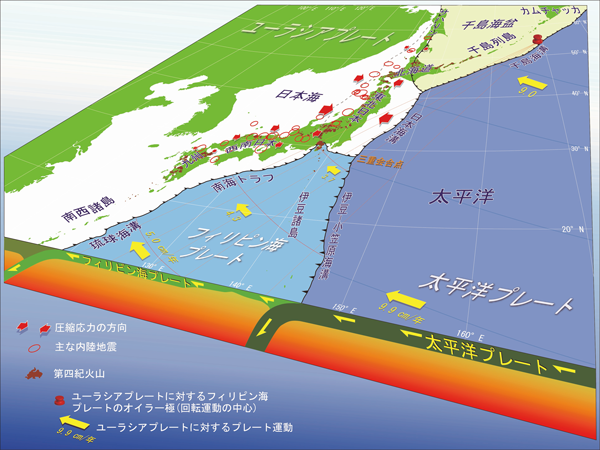
この図は、「国立研究開発法人 産業技術総合研究所(「産総研」)」のホームページから、「日本列島周辺のプレート運動と頻発する内陸地震 本州の広い範囲は東西方向に押されている(図中の赤矢印)」と題する図を引用したものである。
本年5月11日未明、午前4時16分千葉県南部を震源とするマグニチュード5.4、震度5強の大きな地震でたたき起こされた方も多いのではないだろうか、筆者もその一人である。上図を見ると、千葉県南部の地震、頻発しているトカラ列島近海の地震がフィリピン海プレートの動きによって起きているのが明確に解る。
問題は、千葉県とトカラ列島の間にある場所、「南海トラフ」である。小刻みなプレートの動きが小さな地震をフィリピン海プレートの北と北西部で発生させていて「地震のエネルギー」が少しずつ放出されているさまが見て取れるが、その間「南海トラフ」では地震の発生はこのところ無い。つまり「地震のエネルギーは放出されていない=溜まっている」ということが予測される。
3.南海トラフ
気象庁のホームページにある「南海トラフ地震」に関連するページには、本年2023年5月10日付けで、以下の様な記述がなされている。
令和5年05月10日
気象庁地震火山部
南海トラフ地震関連解説情報
** 見出し **
第67回南海トラフ沿いの地震に関する評価検討会、第445回地震防災対策強化地域判定会で、南海トラフ周辺の地殻活動を評価しました。
** 本文 **
本日(5月10日)開催した第67回南海トラフ沿いの地震に関する評価検討会、第445回地震防災対策強化地域判定会で評価した、南海トラフ周辺の地殻活動の調査結果は以下のとおりです。
現在のところ、南海トラフ沿いの大規模地震の発生の可能性が平常時(注)と比べて相対的に高まったと考えられる特段の変化は観測されていません。
(注)南海トラフ沿いの大規模地震(M8からM9クラス)は、「平常時」においても今後30年以内に発生する確率が70から80%であり、昭和東南海地震・昭和南海地震の発生から約80年が経過していることから切迫性の高い状態です。
果たしてそうなのだろうか、日本を代表するような高い知見と経験を有する地震の専門家、研究者が検討、検証した結果発表としてこのとおりだろう、しかし、筆者は2011年3月東日本大震災発生の前後を思い出すとそう安閑とはしていられない。
1997年より13年間委嘱されていた財閥系大手生命保険会社の損害保険事業に関する経営コンサルティングを2009年3月に終え、その後2年間にわたり委嘱された日本最大級の共済団体及び傘下の損害保険会社の経営コンサルティングも終え、「早めにリタイアして第二の人生を」と考えて、以前から関心のあった「地震リスク」を「頭の体操」として個人的に勉強し始めたころであった。これが、その後始めた「グローバル・リンク」の地震保険を中心とした「キャプティブ事業」に繋がるとは考えもしなかったが。
いまだにファイルに残している、その頃垣間見た情報の一つに 「政府 地震調査研究本部」の「月例報告2011年2月」がある。同本部地震調査委員会が、その月例報告を発表したのは、2011年3月9日であった。
「2.各地方別の地震活動 」の「(2)東北地方」の箇所には以下の記述があった。
○ 2月10日に福島県沖の深さ約50kmでマグニチュード(M)5.4の地震が発生した。この地震の発震機構は西北西-東南東方向に圧力軸を持つ逆断層型で、太平洋プレートと陸のプレートの境界で発生した地震である。
○2月27日に福島県沖の深さ約45km で M5.2の地震が発生した。この地震の発 震機構は西北西-東南東方向に圧力軸を持つ逆断層型で、太平洋プレートと陸の プレートの境界で発生した地震である。
そして、「2011年2月の地震活動の評価についての補足説明」のページにある「2.各地方別の地震活動」の「(2)東北地方」の箇所には次の記述があった。
三陸沖で2月 13 日から M5.0 以上の地震が4回発生するなどのまとまった地震活動があった。最大の地震は、16日に発生した M5.5であった。発震機構はいずれも西北西-東南東方向に圧力軸を持つ逆断層型で、太平洋プレートと陸のプレートの境界で発生した地震である。
これらのどこにも、「大震災を予測するような言葉」は無い。そして、この発表の僅か2日後、3月11日、三陸沖でM9.0の東日本大震災が発生したのである。
最大震度7を観測、大津波を北海道地方、東北地方、関東地方の太平洋沿岸で観測、死者・行方不明者2万人以上の甚大な被害が生じた。「想定外」という言葉がマスコミを賑わした、日本の英知を集めた地震の専門家達でも全く予見できない大震災が発生したのである。
今回のまとめ
家庭にある「テーブル」に家族がついて食事をしている時、急に父親がテーブルにドンと手を突いて立ち上がるとテーブル上のモノに何が起きるか。
頑丈なテーブルであれば多少の振動が他の家族の方にある程度だが、もしそのテーブルが「柔らかな素材でできたテーブル」であればどうだろうか。他の家族が座っているテーブルの部分はその影響で大きく持ち上がることになる。
地球の外殻を構成するプレートは、表面は頑丈な岩石で構成されているが、乗っている土台は「マグマ=液状化した柔らかい岩石」である。上述の「テーブルの話」から、プレートのどこで起きた地震であってもそのプレートが接している日本列島の場所には確実に影響を与えるということが予測できる。
南海トラフ巨大地震の想定震源域は、3つに分かれている。静岡地方を想定震源域とする「東海地震」、愛知、三重、和歌山を想定震源域とする「東南海地震」、その以西宮崎沖まで伸びる想定震源域を持つ地震が「南海地震」である。時間差があっても、これら3つの震源域が連動する可能性が高く、更には「東日本大震災を遙かに凌ぐ、超巨大震災になる」と予測されている。
地震リスク以外の大半のリスクは、世界的にも評価の高い日本の損害保険会社であれば、問題なく十分に補償できる。しかし、「地震リスク」はどうだろうか。地震リスクは、日本の損害保険会社の引受力(キャパシティ)では、企業が求める補償を十分に受けることは困難であり、そのコスト(保険料)はかなりのレベルとなる。
「キャプティブを設立して世界的規模を有する信用のおける海外の再保険会社から引受力(キャパシティ)を得た方が、遙かに廉価な保険料で、遙かに大きな金額の地震リスクの補償を受けることができる」。これがグローバル・リンクが、「地震リスクへの対応を主目的とするキャプティブ」の設立を推奨し続けてきた理由である。
「災害は忘れた頃にやってくる」と言われている、頻繁に続く「トカラ列島近海の小刻みな地震、そして新島、神津島の地震」を天の啓示と捉え、コロナ禍が少しずつその影響を落としつつある今、早急に地震保険キャプティブを設立して「南海トラフ巨大地震対応策」の手を打つべき時ではないだろうか。
執筆・翻訳者:羽谷 信一郎
English Translation
Captive (CA) 51 – Preparing for the Nankai Trough Mega Earthquake (movement of the Philippine Sea Plate)
The Japan Meteorological Agency’s Earthquake Information List shows that since the beginning of May this year, earthquakes of magnitudes 3-4 on the Richter scale and intensity 1-3 have occurred constantly in the seas around the Tokara Islands, south of Tanegashima and Yaku Island, Kagoshima Prefecture. The largest of these earthquakes occurred at 4:10pm on 13 May, with a maximum intensity of 5.1 on the Richter scale.
The epicentre of the earthquake was 10 km deep, at a depth where the plate is thought to be in contact with the mantle, which means that the earthquake can be assumed to have been caused by plate subduction.
And today, 22 May, at 4:42pm, an earthquake of magnitude 5.3 occurred with an epicentre near Niijima and Kozushima, Tokyo, with a depth of 10km. The epicentre is where the Philippine Sea Plate meets the Japanese archipelago and the Izu Peninsula, as is clear from the diagram “2. Eurasian Plate”.
1. the Philippine Sea Plate
30 January 2023 of this year, “CA47: Will major earthquakes abroad affect Japan? (Necessity of captives)”. It opened with the following statement.
On 18 January 2023, the following was reported on tenki.jp, a website providing weather forecasts operated by the Japan Weather Association.
At around 15:06 on 18 January, there was an earthquake of a large scale overseas. The earthquake may cause some sea level fluctuations along the coast of Japan, but there is no danger of damage. There is a possibility of tsunami generation in the vicinity of the epicentre. The Japan Meteorological Agency has issued a Northwest Pacific Tsunami Information at 15:20 on 18 March.
This overseas “earthquake of major magnitude” refers to a magnitude (M) 7.2 earthquake with its epicentre in the Molucca Sea in central Indonesia, south of the Philippines. The author was driven to anxiety by this news, hoping that it would not trigger a “Nankai Trough mega earthquake”.
The following diagram will help to explain why I was concerned that the Indonesian earthquake could trigger a Nankai Trough earthquake.
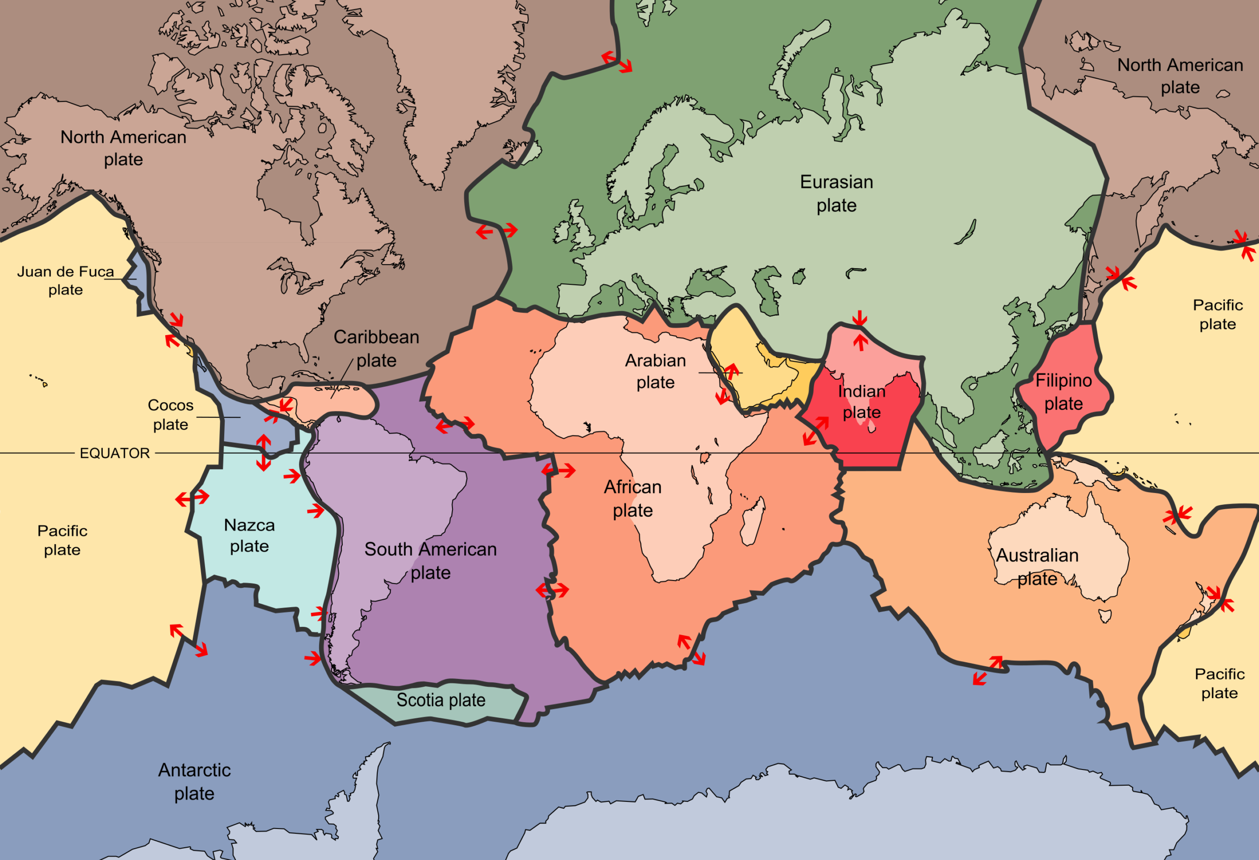
(Source: USGS, Washiucho)
This is a map showing “the ‘plates’ covering the surface of the Earth”, as shown in the latest geophysics. The Molucca Sea, where the magnitude 7.2 earthquake occurred, is “the sea area around the southernmost tip of the Philippine Sea Plate”, and the place where the Philippine Sea Plate meets the Japanese Islands at the top of this map is known as the “Nankai Trough”.
In other words, the magnitude 7.2 earthquake was a major earthquake on the opposite side of the Philippine Sea Plate, where the Nankai Trough exists, and its effects can be expected to spread to the entire plate in no small degree.
However, media reports in Japan were “There was a large earthquake overseas. The earthquake may cause some sea level changes along the Japanese coast, but there is no danger of damage.” This is the same as the following.
It is self-evident that “if a force is applied to one side of the table, the energy will affect all the dishes on the same table” in the home, but for some reason this seems to be neglected in the global table, the “plates”.
This is the reason why the author has been calling for the urgent establishment of captives as a countermeasure against major seismic risks.
The north-west of the Philippine Sea Plate meets the Eurasian Plate in the above diagram, which is the Tokara Archipelago and the Nankai Trough.
2. the Eurasian Plate
A more detailed diagram of where the Philippine Sea Plate is subducting into the continental plate, the Eurasian Plate, provides an insight into the causes of the recent spate of earthquakes.
This diagram is taken from the website of the National Institute of Advanced Industrial Science and Technology (“AIST”), which has a diagram entitled “Plate movement around the Japanese Islands and frequent inland earthquakes: large areas of Honshu are being pushed in an east-west direction (red arrows in the diagram)”. The diagram entitled “The Japanese Islands are being pushed in an east-west direction (red arrows in the diagram)” is quoted from the same website.
Many people may have been awakened by a major earthquake at 4:16 am on 11 May this year, with a magnitude of 5.4 on the Richter scale and an intensity of 5 or higher, centred in southern Chiba Prefecture, and I was one of them. The above diagram clearly shows that the earthquake in southern Chiba Prefecture and the frequent earthquakes near the Tokara Archipelago are caused by the movement of the Philippine Sea Plate.
The problem is the Nankai Trough, which lies between Chiba Prefecture and the Tokara Islands. Small plate movements are causing small earthquakes in the north and north-west of the Philippine Sea Plate, and it can be seen that ‘seismic energy’ is being released little by little, while there have been no earthquakes in the ‘Nankai Trough’ at the moment. In other words, it is predicted that “seismic energy is not being released = it is accumulating”.
3. the Nankai Trough
The page on the JMA website relating to “Nankai Trough Earthquakes” contains the following statement, dated 10 May this year, 2023.
10 May 2023.
Earthquake and Volcanology Department, Japan Meteorological Agency
Nankai Trough Earthquake Related Explanatory Information
Heading **.
The crustal activity around the Nankai Trough was evaluated at the 67th Evaluation Study Meeting on Earthquakes along the Nankai Trough and the 445th Decision Meeting on Areas for Strengthening Earthquake Disaster Prevention Measures.
** Main text **
The following are the results of the investigation of crustal activity around the Nankai Trough, which was assessed at the 67th Assessment Study Meeting on Earthquakes along the Nankai Trough and the 445th Decision Meeting on Areas for Strengthening Earthquake Disaster Prevention Measures, held today (10 May).
At present, no particular changes have been observed that could be considered as a relative increase in the likelihood of a major earthquake along the Nankai Trough compared to normal conditions (see note).
(Note: A large-scale earthquake (M8 to M9 class) along the Nankai Trough has a 70-80% probability of occurring within the next 30 years even under ‘normal conditions’, which is highly imminent as approximately 80 years have passed since the Showa Tonankai and Showa Nankai earthquakes occurred.
This may be true as a result of the examination and verification of earthquake experts and researchers with a high level of knowledge and experience representing Japan, but the author cannot rest easy when recalling the period around the occurrence of the Great East Japan Earthquake in March 2011.
In March 2009, I finished management consulting for the non-life insurance business of a major zaibatsu-affiliated life insurance company, which I had been commissioned to do for 13 years since 1997, and I also finished management consulting for one of Japan’s largest mutual insurance organisations and its affiliated non-life insurance company, which I had been commissioned to do for two years. This was around the time when I began to study earthquake risk, a subject I had been interested in for some time, as a ‘mental exercise’. I had no idea that this would lead to the captive business I later started with Global Link, focusing on earthquake insurance.
One piece of information I still have on file from those days is the Monthly Report February 2011 of the Government’s Headquarters for Earthquake Research and Investigation. The monthly report was released by the Headquarters’ Earthquake Research Committee on 9 March 2011.
In the section “(2) Tohoku Region” of “2. Seismic activity by region”, the following description was made.
On 10 February, a magnitude (M) 5.4 earthquake occurred at a depth of approximately 50 km off the coast of Fukushima Prefecture. The seismic mechanism of this earthquake was a reverse fault type with a pressure axis in the west-northwest-east-southeast direction, and the earthquake occurred at the boundary between the Pacific Plate and the land plate.
On 27 February, an earthquake of M5.2 occurred off the coast of Fukushima Prefecture at a depth of about 45 km. The earthquake was of a reverse fault type with a pressure axis in the west-northwest-east-southeast direction and occurred at the boundary between the Pacific Plate and the land plate.
The following description was found in the section “(2) Tohoku Region” of “2. Seismic activity by region” on the page “Supplementary explanation of the assessment of seismic activity in February 2011”.
There was a series of seismic activity, including four earthquakes of M5.0 or greater off the coast of Sanriku from 13 February. The largest earthquake was M5.5, which occurred on 16 February. The seismic mechanisms were all reverse fault-type with a pressure axis in the west-northwest-east-southeast direction, and the earthquakes occurred at the boundary between the Pacific Plate and the land plate.
Nowhere in any of these is there any ‘word that predicts a major earthquake’. Just two days after this announcement, on 11 March, the Great East Japan Earthquake of magnitude 9.0 occurred off the coast of Sanriku.
A maximum intensity of 7 was recorded, a massive tsunami was observed along the Pacific coast of the Hokkaido, Tohoku and Kanto regions, and more than 20 000 people were killed or missing, causing extensive damage. The word ‘unforeseen’ was used by the mass media to describe the earthquake, which was completely unforeseeable even to Japan’s most knowledgeable earthquake experts.
Summary of this issue
When a family is sitting at the ‘table’ at home eating a meal, what will happen to the objects on the table if the father suddenly stands up and puts his hand on the table with a thud?
If the table is a sturdy table, there will be some vibration towards the other family members, but what if the table is ‘a table made of soft material’? The part of the table on which the other family members are sitting would be lifted significantly by the effect.
The plates that make up the outer shell of the Earth are made up of solid rock on the surface, but the base on which they ride is ‘magma = liquefied soft rock’. From the above-mentioned ‘table talk’, it can be predicted that an earthquake occurring anywhere on a plate will definitely affect the location of the Japanese Islands where that plate touches.
The assumed epicentre area of a major Nankai Trough earthquake is divided into three parts. The Tokai earthquake has an assumed epicentre in the Shizuoka region, the Tonankai earthquake has an assumed epicentre in Aichi, Mie and Wakayama, and the Nankai earthquake has an assumed epicentre extending westwards to off Miyazaki. Even though there is a time lag, there is a high probability that these three epicentre areas will interlock, and furthermore, it is predicted that the earthquake will be of “far greater magnitude than the Great East Japan Earthquake”.
Most risks other than earthquake risk can be adequately covered by Japanese non-life insurance companies, which have a good reputation worldwide, without any problems. But what about ‘earthquake risk’? Earthquake risk is difficult for Japanese non-life insurers to adequately compensate companies for with their underwriting capacity, and the costs (premiums) are substantial.
“It would be far cheaper to set up a captive and obtain underwriting capacity from a reputable foreign reinsurer with global scale, which would provide a far greater amount of earthquake risk coverage at a far lower premium”. This is why Global Link has continued to recommend the establishment of “captives whose primary purpose is to address earthquake risk”.
It is said that “disasters come just when you have forgotten about them”, and with the frequent and continuous “minor earthquakes in the seas around the Tokara Archipelago” being seen as a sign from heaven, and the corona disaster gradually losing its impact, it may be time to establish an earthquake insurance captive as soon as possible and take steps to “prepare for a major earthquake in the Nankai Trough”.
Author/translator: Shinichiro Hatani