
キャプティブ 2024.05.31
CA 60 「天災は忘れた頃にやってくる」
Copyright © Shinichiro Hatani 2024 All rights reserved
For those who prefer to read this column in English, the Japanese text is followed by a British English translation, so please scroll down to the bottom of the Japanese text.
先月、4月18日、「A 59『中央構造線』上、豊後水道で起きた4月17日の地震」と題した一文を本コラムに投稿した。その中に以下のように記した。
2.「中央構造線」上で起きた地震
日本列島の真ん中にある大地溝帯、「フォッサマグナ」を境にして、西半分は「ユーラシアプレート」、東半分は「北米プレート」とその「土台」が別れている。
更に、RM73「地名に潜むリスク」へ備えるキャプティブ 7(「瓜生島沈没」大分)に詳しく記したが、大分県の有名な温泉地である由布院に源を発し別府湾に注ぎ込む「大分川」の下を日本列島の背骨のように、この長さ1,000kmに及ぶ長大な大断層帯「中央構造線」が通っている。
中央構造線は、茨城から関東を通り、諏訪を経て、三重、和歌山、さらに四国を縦断して大分に入り、九州の八代、熊本を経て太平洋へ抜ける長大な大断層帯である。九州、大分県から熊本県に至る一帯を走る中央構造線上には、別府温泉をはじめ湯布院と有名な温泉地が連なっていて、この温泉地熱現象には新しい火山活動や地震が活発な地域である。
「古代地名語源辞典」(楠原祐介ほか(編著) 東京堂出版(刊))には、大分(おおいた)は「おほいた」と読み「オホは美祢(みね)イタはキダの転で、『刻まれたような地形』、つまり段丘を呼んだ地名である。」と記されている。
この「段丘」とは、地殻変動等によってもともと海底や川底であった場所が隆起することによって形成される「隆起地帯」に発達した地形であり、プレートが複雑に入り組んでいて地震の多い地域で多くみられる地形である。
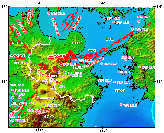
上図は、政府「地震調査研究推進本部」のホームページにある「大分県の地震活動の特徴」のページから引用したものであるが、真ん中にある「別府湾」下に「中央構造線断層帯」と赤字で記されているものである。
その上に、「1596 M7.0」とあるものが「慶長豊後地震」と呼ばれるものであり、「南蛮船の見える町―わがバテレン・宗麟・瓜生島 加藤 知弘 (著) 石風社(刊)」には、「湯布院の奥から、大分市内、そして別府湾に注ぐ大分川、この河口の沖合に陸地と砂州で繋がった島、南蛮貿易で栄えた『瓜生島』と『久光島』があったが、この2島が、1596年9月発生した『慶長豊後地震』で、一夜にして海に沈み、島の住人の多くが犠牲になった」という「伝説」が記されている。
別府湾に沈んだ「瓜生島」のこの話が語りつがれてきたが、歴史的資料が乏しく、あくまでも「瓜生島沈没」は伝説の域を出なかった。しかし、近年様々な研究者によってその実態が解き明かされつつあり、かなりの角度でその信憑性が論議されるようになってきている。
昨日、4月17日の「震源:豊後水道、震源の深さ:約50キロ、地震の規模:マグニチュード(M)6.4の地震」はこの場所で起きたのである。
そして、本日2024年5月31日、気象庁ホームページには、今朝未明熊本地方で起きた地震に関して下記が記された。
地震検知日時 緯度 経度 マグニチュード 震源の深さ 震央地名 2024/05/31 04:46 北緯32.6度 東経130.7度 4.6 10km 熊本県熊本地方
1.中央構造線
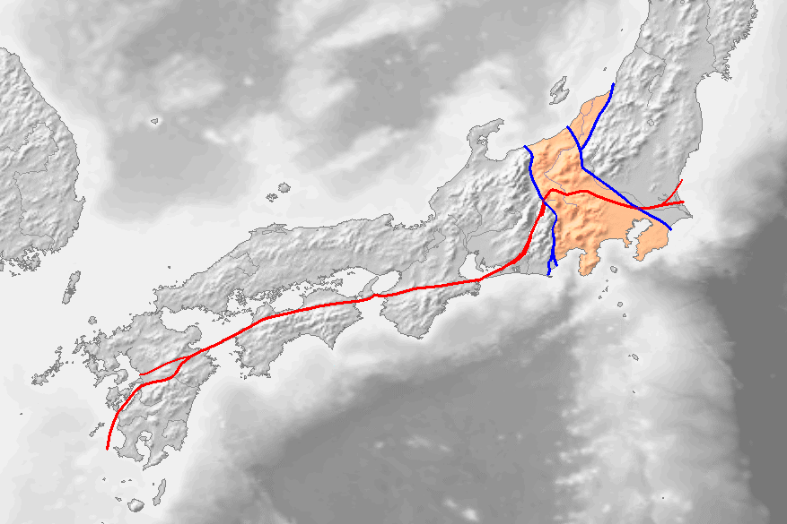
出典:ウィキメディア・コモンズ (Wikimedia Commons)
上図には、関東から九州に伸びる「赤いライン」が記されている。断層の大規模な動きによって、断層の両側に違う岩石が並び、異なる地質の境界線になっている断層を「構造線」と呼ぶが、この赤いラインは、九州、熊本の八代から、徳島、三重、そして諏訪を経て、茨城から太平洋へ抜ける、1000Km以上もある長大な「構造線」であり、「中央構造線」と呼ばれるものである。英語では、「中央構造線」はMedian Tectonic Line(MTL)と呼ばれている。
日本列島の地殻変動は、海側のフィリピン海プレート、太平洋プレートが陸側のユーラシアプレート、北米プレートに沈み込む際、そのエネルギーのベクトルが異なるため、「中央構造線」のなかでも「活断層化している区間」と「活断層化していない区間」が別れ、更に「活断層化している区間」でも、断層の動きと頻度が異なっている。
岡田篤正京都大学名誉教授の論文「中央構造線活断層系の活動区の分割試案 (中央構造線のネオテクトニクス–その意義と問題点)」には以下の一文がある:
地表に活断層のずれ動きが生じるのは数百年~数万年に1回で、1回の食い違いは10m以内です。しかし数10万年もずれ動きが繰り返されると、合計の食い違い量は数10m~10数kmに達します。この長期間の食い違いの速度を「活動度」と言い、ふつうは1000年あたりの平均値で表します。1000年平均で1m~10mの食い違い速度(変位速度)の活断層をA級、10cm~1mのものをB級、1cm~10cmのものをC級に区分します。
更に、このうち、「大きな“食い違い”」、つまり活動量が多く、断層型地震が起きた場合、大きな地震になる可能性のある「A級」とされている区間は、次のとおりである。
活断層区 場所 長さ(km) 活動度 紀伊半島西 五条~紀淡海峡 70 A 淡路島 紀淡海峡~鳴門海峡 30 A? 四国北東 鳴門~伊予三島 106 A 四国中央 伊予三島~小松 47 A
つまり、1000km以上に及ぶ中央構造線のうち、「活動の度合いが高い区間」が紀伊半島から四国に集中していて、その先にあるのが本年4月17日に大きな地震が起きた豊後水道であり、そしてこの中央構造線は、今朝地震が起きた熊本に辿り着くのである。
2.熊本地震
2016年4月発生した「熊本地震」の後、多くの被災者が「熊本には大きな地震は来ないと思っていた」と語っていたことを記憶している。しかし、歴史をひもとけば、熊本は、度々大きな地震、津波に襲われていたことが分かる。
1792年(寛政4年)に熊本を襲った大津波の犠牲者を弔う慰霊碑が熊本市西区河内町にある。1991年に噴火、火砕流が発生、43名の犠牲者を出した雲仙普賢岳は、200年前の1792年、日本の歴史上最大の火山災害を引き起こしている。前年から雲仙岳周辺では地震が頻発していたが、1792年2月10日普賢岳が噴火、溶岩流が流れ出した。その後、3月には雲仙火山の一つ、眉山近くで地震が続いていたが4月1日になり、2度の大地震によって眉山が大規模な山体崩壊を起こし、3億立方メートル以上というとてつもない量の土砂が有明海に流れ込んだ。
そのために発生した高さ20mを超える大津波は、島原のみならず対岸の熊本、天草に押し寄せ、犠牲者は約15,000人に達した。このことから、「島原大変肥後迷惑」という言葉が生まれ今に残っている。
このとき河内一帯の「庄屋」であった鹿子木量平(かのこぎりょうへい)は、後世に伝えるため「津波教訓碑」の建立を藩に願い出て、1795年多くの人々が拠出した資金で完成した。そこには「家から荷物を持ち出そうとした人の多くは溺死した。
だから、津波が来たらすべてのことに優先してお年寄りを助け、幼い子供を連れてすぐに逃げなければならない。予め逃げ道を確認しておき、いざというとき迷ってはいけない」とそこには記されている。東日本大震災の際に「津波てんでんこ」という言葉が多くのメディアで報道されたことを思い出す。
3.津波てんでんこ
「津波てんでんこ」とは、「津波からの避難の標語」である。1990年、後の東日本大震災で多くの犠牲、損害を被った岩手県下閉伊郡田老町(現・宮古市)で開催された、第1回「全国沿岸市町村津波サミット」において、生まれた言葉である。田老町は、リアス式海岸の奥に位置し、何度も津波の被害を受けていたため、高さ10mの防潮堤を総延長2.5kmに渡って建設、世界最強の防潮堤、「日本の”万里の長城”」とまで言われていた。津波に対して強い街づくりを進めていた、国内外から絶賛されていた防災の町が、旧田老町であった。しかし、そんな人々の思いも空しく、2011年の東日本大震災では、その防潮堤を越える大津波が発生、防潮堤は粉々にされ、甚大な被害が発生したのである。
「てんでんこ」は、「各自」「めいめい」を意味する名詞「てんでん」に、東北方言などで見られる「こ」が付いた言葉。すなわち、「津波てんでんこ」「命てんでんこ」をそのまま標準語に置き換えると、前者は「津波はめいめい」、後者は「命は各自」になる。つまり、それぞれ「津波が来たら、取る物も取り敢えず、肉親にも構わずに、各自てんでんばらばらに一人で高台へと逃げろ」、「自分の命は自分で守れ」になると言われている。また、「万が一、自分自身は助かり他人を助けられなかったとしてもそれを非難しない」という不文律でもあるという意味を言外に含むと言われている。
岩手県釜石市の3,000人近い小中学生がこれを実践して、そのほぼ全員が避難、奇跡的に無事だった。市内でも最も大きな被害が発生した「鵜住居(うのすまい)地区」、釜石東中学校の生徒達は直ちに学校を飛び出し、「てんでんこ」で、高台をめがけて走った。彼らを見て、近所の鵜住居小学校の児童や先生達もあとに続き、さらには多くの住民もそれに倣った。年下の児童達を助けながら走り続け、安全な場所に辿りついた。その時、彼らの背後には、巨大な津波が、学校を、そして町を飲み込んでいた。釜石市では1,000人以上が亡くなったが、子ども達の犠牲は、たまたま津波が襲った時、学校にいなかった5人のみであった。子どもたちが無事に避難した話は、「釜石の奇跡」として、大震災後広く知られるようになった。
メディアでも多く取り上げられたが、生徒達が迅速な対応をすることができたのは、釜石市内の学校が、当時、群馬大学教授であった片田敏孝氏の指導のもと、数年間「防災教育プログラム」に取り組んでいた成果であった。河川防災の専門家であった片田教授は、2004年インド洋の津波による悲惨な被害現状を見て、津波防災に取り組むようになったということである。この「防災教育プログラム」という言葉を企業用に置き換えると、それは「リスクマネジメント」になる。
今回のまとめ
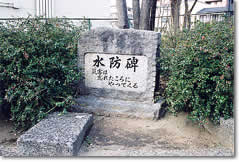
「ノーベル賞候補」と評された世界的な物理学者、寺田寅彦の有名な言葉に、「天災は忘れた頃にやってくる」という言葉がある。この言葉に由来する「災害は忘れたころにやってくる」の文字は、大阪市の桜之宮公園にある「水防碑」に刻まれている。」
「今後30年で発生確率は70~80%」と言われている南海トラフ巨大地震に比べ、国内最大の活断層である「中央構造線断層帯」を震源とする直下型地震は、「今後30年以内0〜0.4%」と発生確率が低いと言われている。
しかし、2016年発生した「熊本地震」の発生前の確率は「30年以内の発生確率0〜0.9%)」と低く、上述のとおり「地震は来ない」と多くの人々は思っていたのである。
また、その後起きた「鳥取県中部地震」では、「未知の断層」が相次ぎ動き大きな地震となった。こういう点からも、「思い込みにとらわれない地震対策が必要である」と筆者は考えている。
キャプティブの設立は、実質的な地震保険コストを大きく低減させることは多くの実例が証明している。「キャプティブ」という「新しい発想」で、地震リスクへの対応を始めるべきタイミングではないだろうか、巨大地震が来る前に。
執筆・翻訳者:羽谷 信一郎
English Translation
Captive (CA) 60 – ‘Natural disasters come when we forget.’
Last month, on 18 April, I posted an article in this column entitled ‘A 59: The 17 April earthquake in the Bungo Channel on the Median Tectonic Line’. In it, I wrote the following.
2. Earthquake that occurred on the ‘Median Tectonic Line’.
The Great Rift Valley in the middle of the Japanese archipelago, the ‘Fossa Magna’, separates the western half from the ‘Eurasian Plate’ and the eastern half from the ‘North American Plate’ and their ‘foundations’.
Furthermore, as described in detail in Captive 7 (‘Sinking of Uryu Island’, Oita), the Median Tectonic Line, a 1,000 km long major fault zone, runs under the Oita River, which originates in Yufuin, a famous hot spring resort in Oita Prefecture, and flows into Beppu Bay, like the backbone of the Japanese archipelago. The Median Tectonic Line runs under the Oita River, which empties into the Oita River.
The Median Tectonic Line is a great fault zone that runs from Ibaraki, through the Kanto region, through Suwa, Mie and Wakayama, across Shikoku, into Oita, through Yatsushiro and Kumamoto in Kyushu and out into the Pacific Ocean. On the Median Tectonic Line, which runs through the area from Oita to Kumamoto prefectures in Kyushu, there is a series of famous hot spring resorts such as Beppu Onsen and Yufuin, and this hot spring geothermal phenomenon is an active area with new volcanic activity and earthquakes.
In the Dictionary of the Etymology of Ancient Place Names (edited by Yusuke Kusuhara et al., Tokyo Do Publishing), Oita is read as Ohoita, ‘Oho is a transcription of Mine and Ita is a transcription of Kida, a place name for a “landform like a carved terrain”, or terrace.’ It is written as follows.
Terraces are landforms that develop in uplift zones, which are formed by the uplift of areas that were originally the seabed or river bottom due to tectonic movements, etc., and are often found in regions where plates are intricately interconnected and earthquakes are frequent.
The figure above is taken from the ‘Characteristics of seismic activity in Oita Prefecture’ page on the website of the government’s Headquarters for Earthquake Research Promotion, where ‘Median Tectonic Line Fault Zone’ is marked in red below ‘Beppu Bay’ in the middle.
Above that, the ‘1596 M7.0’ is called the ‘Keicho-Bungo Earthquake’, and in ‘A Town with a View of Nanban Ships – My Bateren, Sorin and Uryu Island’, Tomohiro Kato (author), published by Ishikaze-sha, states that ‘From behind Yufuin, Oita City and the Oita River flowing into Beppu Bay, the land and the island connected to the land offshore of this river mouth are called the Nanban Ships. These two islands sank into the sea overnight during the Keicho Bungo Earthquake of September 1596, killing many of the island’s inhabitants.
This story of Uryu Island sinking in Beppu Bay has been passed down through the ages, but due to a lack of historical data, the ‘sinking of Uryu Island’ has remained a legend. In recent years, however, various researchers have begun to uncover the reality of the story, and its veracity is being debated from a number of angles.
Yesterday, 17 April, an earthquake of epicentre: Bungo Channel, epicentre depth: 50 km, magnitude (M) 6.4 occurred at this location.
And today, 31 May 2024, the JMA website recorded the following information about the earthquake that occurred in the Kumamoto region early this morning.
Date and time of earthquake detection Latitude Longitude Magnitude Depth of epicentre Name of epicentre
2024/05/31 04:46 N 32.6 E 130.7 4.6 10 km Kumamoto region, Kumamoto Prefecture, Japan
1. Median Tectonic Line
The diagram above shows a ‘red line’ extending from Kanto to Kyushu. A fault line is a fault line where different rocks line up on both sides of a fault line due to large-scale movement of the fault, forming a boundary line between different geological features. It is called the ‘Median Tectonic Line’. In English, the Median Tectonic Line is called the Median Tectonic Line (MTL).
The crustal movement of the Japanese Islands is caused by the subduction of the Philippine Sea Plate and Pacific Plate on the ocean side into the Eurasian Plate and North American Plate on the land side, and the energy vectors are different. Even in ‘active faulted sections’, the movement and frequency of faulting is different.
In the article ‘Tentative plan for dividing the active zone of the Median Tectonic Line active fault system (Neotectonics of the Median Tectonic Line – its significance and problems)’ by Professor Emeritus Atsumasa Okada of Kyoto University, it is stated that the active fault system is divided into ‘active faulted zone’ and ‘not active faulted zone’:
Displacement movements of active faults on the earth’s surface occur only once every few hundred to tens of thousands of years, and each discrepancy is within 10 m. However, if the displacement movements are repeated for several hundred thousand years, the total amount of discrepancies can reach several tens of metres to several tens of kilometres. The long-term discrepancy speed is called the ‘activity level’ and is usually expressed as an average value per 1000 years: active faults with a 1000-year average discrepancy speed (displacement speed) between 1 m and 10 m are classified as Class A, those between 10 cm and 1 m as Class B, and those between 1 cm and 10 cm as Class C.
Furthermore, of these, the sections that are considered ‘Class A’ with ‘large “discrepancies”’, i.e. high activity and the potential to cause a major earthquake if a fault-type earthquake occurs, are as follows.
Active fault zone Location Length (km) Degree of activity
West Kii Peninsula Gojo to Kitan Strait 70 A
Awaji Island Kitan Strait – Naruto Strait 30 A?
North-east Shikoku Naruto to Iyo Mishima 106 A
Central Shikoku Iyomishima – Komatsu 47 A
In other words, the ‘highly active section’ of the Median Tectonic Line, which extends over 1000 km, is concentrated from the Kii Peninsula to Shikoku, beyond which is the Bungo Channel, where a major earthquake occurred on 17 April this year, and the Median Tectonic Line reaches Kumamoto, where an earthquake occurred this morning.
2. The Kumamoto earthquake
After the Kumamoto Earthquake in April 2016, many victims remember saying that they thought there would be no major earthquake in Kumamoto. However, history shows that Kumamoto has been hit by major earthquakes and tsunamis frequently.
Unzen Fugendake, which erupted in 1991, triggering pyroclastic flows and killing 43 people, caused the largest volcanic disaster in Japanese history 200 years ago in 1792. Earthquakes had been frequent in the area around Mount Unzen since the previous year, but on 10 February 1792 Fugendake erupted and lava flows began to flow out. Then, in March, earthquakes continued to occur near Bizan, one of the Unzen volcanoes, but on 1 April, two major earthquakes caused a massive collapse of Bizan, and a tremendous amount of sediment, over 300 million cubic metres, flowed into the Ariake Sea.
The resulting tsunami, more than 20 metres high, swept not only into Shimabara but also into Kumamoto and Amakusa on the opposite shore, claiming some 15,000 victims. This gave rise to the phrase ‘Shimabara Daishi Higo Nuisance’, which has survived to this day.
Kanokogiryohei, the headman of the Kawachi area at the time, asked the clan to erect a ‘Tsunami Lesson Monument’ to be handed down to future generations, which was completed in 1795 with funds contributed by many people. It states: ‘Many people who tried to take their belongings out of their houses drowned. Therefore, when a tsunami comes, you must give priority to everything else, save the elderly, take young children and run away immediately. Check the escape route beforehand and do not get lost in case of emergency’. The term ‘Tsunami Tendenko’ was reported in many media outlets after the Great East Japan Earthquake.
3. Tsunami Tendenko
“Tsunami-tendenko” is a motto for tsunami evacuation, which was coined at the first National Coastal Tsunami Summit held in 1990 in the town of Taro-cho, Shimojimei-gun (now Miyako City), Iwate Prefecture, which suffered a great deal of loss and damage in the Great East Japan Earthquake. The town of Taro-cho, located at the end of a rias coast, was repeatedly hit by tsunamis, so a 10-metre-high sea dike was built over a total length of 2.5 km, making it the strongest sea dike in the world, and was even called the ‘Great Wall of Japan’. The former town of Taro was a highly praised disaster-prevention town, both at home and abroad, which was building a town resistant to tsunamis. However, the people’s hopes were dashed by the 2011 Great East Japan Earthquake, when a massive tsunami surged over the seawall, smashing it to pieces and causing extensive damage.
The word ‘Tendenko’ is the noun ‘Tenden’ meaning ‘each one’ or ‘each name’, with ‘ko’ added, as in the Tohoku dialect. In other words, if ‘tsunami-tendenko’ and ‘life-tendenko’ are replaced directly in standard Japanese, the former becomes ‘tsunami wa meimei’ and the latter ‘life wa each of you’. In other words, the former is ‘When a tsunami comes, run to high ground alone, without taking anything and without caring about your relatives’ and the latter is ‘Protect your own life by yourself’, respectively. It is also said to contain the unwritten meaning of ‘If you save yourself and fail to save others, do not blame them’.
Nearly 3,000 primary and junior high school students in Kamaishi City, Iwate Prefecture, put this into practice and almost all of them evacuated and miraculously survived. In the Unosumai area, the hardest hit area in the city, students from Kamaishi Higashi Junior High School immediately ran out of school and ran towards higher ground in a ‘tendenko’. Seeing them, pupils and teachers from the nearby Unosumai Primary School followed them, and many other residents also followed. They kept running, helping the younger children, until they reached a safe place. By then, behind them, a huge tsunami had swallowed the school and the town. More than 1,000 people died in Kamaishi, but only five children were killed, who happened to be out of school when the tsunami hit. The story of the children’s safe evacuation became widely known after the disaster as the ‘Miracle of Kamaishi’.
Much media coverage was given to the story, and the pupils’ quick response was the result of several years of work by schools in Kamaishi on a “disaster education programme” under the guidance of Toshitaka Katada, who was a professor at Gunma University at the time. Professor Katada, who was an expert in river disaster prevention, was inspired to work on tsunami disaster prevention after seeing the devastating damage caused by the 2004 Indian Ocean tsunami. If the term ‘disaster education programme’ were to be replaced by the term ‘risk management’ for companies, it would be ‘risk management’.
Summary of this issue
The world-renowned physicist Torahiko Terada, who was described as a ‘Nobel Prize candidate’, famously said that ‘natural disasters come when we forget them’. The words ‘Disasters come when we forget them’ are inscribed on the Flood Prevention Monument in Sakuranomiya Park, Osaka.’
Compared to the Nankai Trough earthquake, which is said to have a ‘70-80% chance of occurring in the next 30 years’, an earthquake directly under the Median Tectonic Line fault zone, the largest active fault in Japan, is said to have a lower probability of occurring, ‘0-0.4% in the next 30 years’.
However, the probability before the 2016 ‘Kumamoto earthquake’ was low, with a ‘0-0.9% probability of occurrence within 30 years’ (0-0.9%), and as mentioned above, many people thought that ‘no earthquake would come’.
In addition, in the subsequent ‘Tottori Chubu Earthquake’, ‘unknown faults’ moved one after another, resulting in a major earthquake. From this point of view, the author believes that ‘earthquake countermeasures that are not bound by assumptions are necessary’.
Many examples have proven that the establishment of captives can significantly reduce the cost of earthquake insurance in real terms. It may be time to start dealing with earthquake risk with the ‘new idea’ of captives, before a major earthquake strikes.
Author/translator: Shinichiro Hatani