
キャプティブ 2024.09.04
CA 64 「『NHKスペシャル』 首都直下地震への警鐘 能登半島地震で見えた地下のリスク」を見て
目次
Copyright © Shinichiro Hatani 2024 All rights reserved
For those who prefer to read this column in English, the Japanese text is followed by a British English translation, so please scroll down to the bottom of the Japanese text.
「未曾有の大災害」と呼ばれた関東大震災が発生したのは、1923年、大正12年、旧満州大連で満鉄に勤務していた祖父のもと私の父が生まれた、私の脳裏に深く刻み込まれている年、この年の9月1日であった。
本年、2024年9月1日、NHKで「『NHKスペシャル』 首都直下地震への警鐘 能登半島地震で見えた地下のリスク | MEGAQUAKE 巨大地震 “軟弱地盤” 新たな脅威 |」という非常に示唆に富んだ、1時間の番組が放送された。NHKの公式YouTubeサイトでは、番組が4分強に纏られている。https://www.youtube.com/watch?v=crvTR1NOycA
番組は、今年1月1日に起きた能登半島地震を調査する学術者達の研究、調査の映像から始まり、「今回の地震は複数の活断層が動いた結果」であり、「16万棟を越える建物が壊れ、300人以上が犠牲になった、能登半島地震の被害は科学者達の想定を遙かに超えるものであった」と示され、「『建物の基礎構造』が専門」と紹介された東京工業大学の田村修次教授の言葉に続いた。
同教授が注目したのは、輪島で横倒しになった7階建でのビルの基礎、「杭基礎」が壊れていたことであった。これまで、「地震」というと上部構造である建物、柱や梁の破壊が映し出されることが多かったが、「見てのとおりガラスは大体残っている、(ビルが)転倒するほどの大きな被害は無いかな」と思う」と、「(倒壊した)輪島のビル」の大きく壊れている「杭基礎」の映像が映し出されていた。
「めり込んでいるように転倒しているので、おそらく、杭または地盤に大きな問題が生じた」「過去、日本で杭が壊れて人が亡くなった事例はおそらくない、今回の事例が初めてなんです」という同教授の言葉に続き、「『なぜ建物が基礎から壊れたのか』、その原因に地盤の影響があると考えている・・・」と述べながら「走行する自動車の僅かな揺れから軟弱地盤かどうかを推定する機器:微動計」を設置する、防災科学技術研究所の先名(せんな)重樹主任専門研究員のインタビューに続いた。
「軟弱地盤は固い地盤に比べて地震の揺れを何倍にも増幅するため『地震のリスクが高い』とされている」と述べ、軟らかい地盤を「プリン」に、強い地盤を「羊羹」に見立てて、「同じを揺れを、同じ厚さのプリンと羊羹に加えるとプリンの方が揺れる」と説明、「軟らかい地盤だと揺れがすごく増幅されるので、固い地盤に比べて震度が1段階でも2段階でも大きくなる」と地盤の強さが地震の被害に与える影響について分かりやすく説明されていた。
「地震によって地震の揺れが何倍に増幅されるのか、その揺れを色によって表わした地図」と紹介しながら、輪島市を「地震によって地盤の揺れが何倍に増幅されるのか」、つまりこの「表層地盤増幅率」によって、「オレンジは揺れが1.6倍以上、赤は2倍以上、転倒したビルがあった紫のエリアは、2.5倍以上の増幅率でした」と区分け、「輪島は想像していた倍ぐらい揺れやすいところもあると非常に驚いている」と感想を述べていた。
「浮かび上がった軟弱地盤の脅威」、「そのリスクは能登半島に限らず、全国に拡がっていると言います、南海トラフ巨大地震で被害が想定されている、九州や四国、大阪、そして日本最大の軟弱地盤が拡がっているのが首都東京を含む関東です」と、全国の「表層地盤増幅率」を記した地図(J-SHIS「表層地盤増幅率」(防災科学技術研究所)を基に作成したもの)が紹介され、「『30年以内に70%の確率で起こると予測されている首都圏直下地震』の被害想定では、『軟弱地盤に建つビルの杭基礎』への影響は考慮されていない」と示し、「地盤が地震の被害に大きな影響を与える存在であること」を詳らかにしていった。
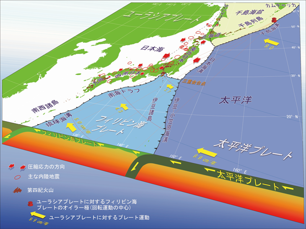
(「国立研究開発法人 産業技術総合研究所(「産総研」)」のホームページ:「日本列島周辺のプレート運動と頻発する内陸地震 本州の広い範囲は東西方向に押されている(図中の赤矢印)」より引用)
(From the website of the National Institute of Advanced Industrial Science and Technology (AIST): ‘Plate Motions around the Japanese Islands and Frequent Inland Earthquakes: Large Areas of Honshu are being pushed in an east-west direction (red arrows in the diagram)’
1.筆者の所感
上記番組では、「地震のリスクを正しく知ることが私たちの命を守ることに繋がっていきます」と続いていたが、「地盤の強さそのものを詳らかにして人々の地震リスク対策に役立てていこうとする方向」から、「耐震基準」の変更の必要性を示唆する方向へと番組は変っていったと筆者は感じた。
確かに、「耐震基準」の変更を求めることは必要だろうが、「国民目線」では、「喫緊の課題である南海トラフ地震等、巨大地震のリスク」を考えると、「今いる場所が、安全か、どれくらい地震リスクがあるのか、どうすべきかを知る方が求められるところ」ではないだろうか。
「耐震基準」の変更を求めても、それが実際の建物に安全性が加味される、つまり、新たに建物が設計され、建築され、完成するまでには、かなりの年月を要することは明らかである。それよりも、番組の視点を「表層地盤増幅率」に更に注ぎ、「どう対応すべきか、どう対処すべきかを述べていく番組となっていれば」と、番組が秀逸なだけに残念な思いがした。
2.建築基準法の耐震基準
建築基準法は、1950年に制定され、耐震基準は、1968年に起きた十勝沖地震を踏まえ鉄筋コンクリート造のせん断補強基準の強化が示された1971年の改正、続いて1978年の宮城県沖地震を受け「大きな改正」が1981年におこなわれ、更に1995年1月17日の阪神・淡路大震災の発生と被害を受けて、2000年に改正が行われた。
1981年5月31日までに確認申請を受けた建物を「旧耐震」、1981年6月1日以降の確認申請を受けた建物を「新耐震」と一般的に呼ばれるほど「大きな改正」がおこなわれたのが「1981年の改正」である。
旧耐震では「震度5程度の中規模の地震で大きな損傷を受けないこと」が基準となっていたが、新耐震では、「中地震では軽微なひび割れ程度の損傷にとどめ、震度6程度の大規模な地震で建物の倒壊や損傷を受けないこと」と、耐震基準がかなり強められたからである。
2000年の建築基準法の改正は、「地盤に応じた基礎設計」「基礎と柱の接合部に金具の取り付け」「耐力壁のバランスと配置」が強化されているが、阪神・淡路大震災で倒壊した建物が木造家屋だったためか、木造住宅に関するもので、鉄筋コンクリート造の建物の耐震基準は、1981年の改正以降変わっていないという事実があるため、先の番組では「問題提起」がなされたのであろう。
3.表層地盤増幅率
筆者は、4年前になるが、2020年11月28日、本コラムに「RM51 地名に潜むリスクへ備えるキャプティブ 2(地震に強い街)」と題した一文のなかで、「表層地盤増幅率」のことを以下のように記したことがある。https://glc-tokyo.com/news_column/p3988/
3. 地盤の強さ
文部科学省の特別機関である「地震調査研究推進本部」が公表している地盤データを基に、「ゲンダイネット」が地震を想定して、2012年1月作成した「揺れに強い東京の街ランキング」で、多摩市が1位となった。
その際に使われた指標は、「表層地盤増幅率」であった。地震の揺れの強さは「規模」と「震源からの距離」によって異なる。ただ、地震の規模と距離が同じでも、揺れの強さは、建物の立つ地盤の固さで大きく変わってくる。地盤が堅固かどうか、「表層地盤」(土地の表層近くの浅い部分)の揺れの大きさを数値化したものが、「表層地盤増幅率」である。1を超えて数値が高くなるほど「揺れに弱い」ことを示すが、「揺れに強い東京の街ランキング」で算出された多摩市の数値は1.04であった。
上記のとおり、「表層地盤増幅率」とは、地表面近くに堆積した地層(表層地盤)の地震時の揺れの大きさを数値化、地震に対する地盤の強弱さを示す数値である。同じ規模の地震が発生しても、その影響を受ける度合いは異なってくる、そのファクターは「地盤の強さ」である。この数値が大きいほど地盤は弱く、揺れは大きくなる。国立研究開発法人防災科学技術研究所(NIED)の分析では、「1.6以上で地盤が弱いことを示す」とされ、「2.0以上は特に揺れやすい」との評価である。
「地震ハザードステーション」のデータに基づいて、東京、関東地域でシミュレーションをおこなってみたら、増幅率の低い(地盤の強い)地域は、東京西側の丘陵地帯、増幅率の高い(地盤の弱い)地域は、東側の旧下町や湾岸エリアに位置していた。
地質学的にみると、山の手は標高の高い洪積台地であるのに対して、下町は海に近く標高の低い沖積低地であり、1923年(大正12年)の関東大震災でも、都心下町の被害が大きかったデータが残されている。
県庁が所在する場所の数値を調べてみたら、千葉市(千葉県)が2.23、横浜市(神奈川県)が2.19、さいたま市(埼玉県)が1.63となっており、東京都心部の山の手エリアよりも高い。一方、北関東では、水戸市が1.86、宇都宮市が1.30、前橋市が1.19となっており、全般的に南関東よりも低い値を示している。
このシミュレーションを拙宅付近でおこなったものが下図である。強固な地盤ということが解る数値である。
表層地盤
地盤増幅率(Vs=400m/s~地表) 1.02 微地形区分 丘陵 30m平均S波速度 393m/s この地盤の強固さを裏付けるように、筆者が多摩市に転居した後、大手メガ損保、大手メガバンク、大手電話通信会社等の都心本社機能を有事の際にバックアップする機能を持たせた会社施設、データセンターが幾つも建設されている。
4.地震ハザードステーション
この「防災科学技術研究所」(略称:防災科研「NIED」)は、1963年4月、当時の「科学技術庁」の附属機関として設立された「国立防災科学技術センター」に淵源を持つ防災に関する科学技術の研究を行う機関であり、本部は茨城県つくば市にあるが、全国各地に実験施設や観測施設を所有している。
この「防災科研(NIED)」のホームページにある、前述の「J-SHIS:地震ハザードステーション」(J-SHIS Map (bosai.go.jp))は秀逸である。「主要活断層帯」、「その他活断層帯」、「海溝型地震震源断層」、「海溝型地震発生領域」、「主要活断層帯地表トレース」等に関して、全国マップの中でそれらが詳述されている。
さらに、地震による影響を受ける地域を、今後30年間で「震度5弱以上」、「震度5強以上」、「震度6弱以上」、「震度6強以上」他、それぞれの揺れに見舞われる確率の分布図が一目瞭然、地震リスクによって自社に及ぶ影響が推測できるものとなっている。
「地震ハザードステーション」のデータに基づいて、東京、関東地域でシミュレーションをおこなってみたら、増幅率の低い(地盤の強い)地域は、東京西側の丘陵地帯、増幅率の高い(地盤の弱い)地域は、東側の旧下町や湾岸エリアに位置していた。
地質学的にみると、山の手は標高の高い洪積台地であるのに対して、下町は海に近く標高の低い沖積低地であり、1923年(大正12年)の関東大震災でも、都心下町の被害が大きかったデータが残されている。
千葉市(千葉県)が2.23、横浜市(神奈川県)が2.19、さいたま市(埼玉県)が1.63となっており、東京都心部の山の手エリアよりも高い。一方、北関東では、水戸市が1.86、宇都宮市が1.30、前橋市が1.19となっており、全般的に南関東よりも低い値を示している。
今回のまとめ
戦前、「ノーベル賞候補」と称された世界的な物理学者、寺田寅彦の言葉に、「天災は忘れた頃にやってくる」という言葉がある。
「天災は忘れた頃にやってくる」という教訓と反して、ある意味日本人を特徴付ける言葉としてよく使われるものに「喉元過ぎれば熱さを忘れる」があるが、関東大震災から100年経って、果たして「忘れた頃にやってくる天災」に対応する体制に日本はなっているのであろうか。それとも「喉元過ぎれば熱さを忘れる」ことになっているのであろうか。
リスクマネジメントとは、「弛まなく継続的に、リスクを洗い出し、検証し、対応していく作業」のことであり、「キャプティブ」は「リスクマネジメントの強固な手段」である。企業にとっては、「常にリスクと向き合う経営戦略」である。「喉元過ぎれば熱さを忘れる」ということを発生させないための手段である。
キャプティブの効用には、「日本では求めることが難しい『世界基準の地震補償、巨額の地震保険補償』を得ることを可能にする」というものがあるが、この「弛まなく継続的に、リスクに接して、対応策を検討、実施する、つまりリスク・マネジメントのコアになる」というキャプティブの別の効用にも目を向けるべきではないだろうか。
日本損害保険協会の行動規範には、「安心かつ安全で持続可能な社会の実現と、経済および国民生活の安定と向上に資する相互扶助制度を円滑に運営することが、損害保険事業の社会的使命として求められている」とある。
つまり、損害保険会社はその社会的使命として、「ある特定の一社にのみ補償を提供することではなく、日本国内の個人、企業に遍く広く補償を提供すること」が求められている。「一社のみの要望に応える存在」になることはできない。だからこそ、「一社のみの要望に応えるキャプティブ」が果たす役割は非常に大きいと言える。
グローバル・リンクが提唱する「ソリューション・キャプティブ®・プログラム」とは、「世界最大級の再保険会社と日本の最大級の保険会社(元受保険会社)がキャプティブを『連結器』にして、一見不可能と思えるような『補償の提供』を廉価で可能にするプログラム」と言えるであろう。
関東大震災から101年目を迎えた本年、果たして日本は、「大震災に対応できる姿」になっているのであろうか。筆者にはそうなっているとは思えない。「キャプティブの設立」をおこない防災態勢を堅固にすべき時ではないだろうか。
東日本大震災の時に使われた言葉、「想定外」を二度と口にしなくて済むようにしなければならない、「天災は忘れた頃にやってくる」からである。
執筆・翻訳者:羽谷 信一郎
English Translation
Captive (CA) 64 – Watching ‘NHK Special: Alarm over a Major Earthquake in the Tokyo Metropolitan Area – The Noto Peninsula Earthquake Reveals the Risk of Underground Faults’
The Great Kanto Earthquake, which was called an unprecedented disaster, occurred on 1 September 1923, the year my father was born in Dalian, Manchuria, where my grandfather was working for the South Manchuria Railway Company.
On 1st September 2024, NHK broadcast a very thought-provoking one-hour programme called ‘NHK Special: Alarm over a Major Earthquake Directly Beneath the Capital – The Noto Peninsula Earthquake Reveals the Risk of Underground Faults – MEGAQUAKE – A Huge Earthquake – “Soft Ground” – A New threats’ was broadcast on NHK. The programme was edited down to just over 4 minutes on NHK’s official YouTube site.
The programme begins with footage of the research and investigations being carried out by academics investigating the Noto Peninsula earthquake that occurred on 1st January this year, and shows that ‘the earthquake was the result of multiple active faults moving’, and that ‘the damage caused by the Noto Peninsula earthquake, which destroyed over 160,000 buildings and killed over 300 people and more than 300 people were killed, the damage caused by the Noto Peninsula earthquake far exceeded the expectations of scientists’, and the film begins with the words of Professor Shuji Tamura of the Tokyo Institute of Technology, who is “specialised in the structural foundations of buildings”.
The professor’s focus was on the fact that the “pile foundations” of a seven-storey building that had toppled over in Wajima had collapsed. Until now, when we think of earthquakes, we often think of the destruction of the upper structure of buildings, such as the destruction of pillars and beams, but following the professor’s words, ‘As you can see, most of the glass is still intact, so I don’t think there was any significant damage that caused the building to collapse,’ images of the heavily damaged ‘pile foundation’ of the collapsed Wajima building were shown.
Following his words, ‘The building has fallen over as if it has sunk into the ground, so there must have been a major problem with the piles or the ground,’ and ‘There are probably no cases in Japan of people dying after piles have collapsed, so this is the first time this has happened,’ he said, ‘I think the reason why the building collapsed from its foundations is … and the influence of the ground…’, followed by an interview with Shigeki Senna, a senior researcher at the National Research Institute for Earth Science and Disaster Prevention, who installed a “microtremor meter”, a device that can estimate whether the ground is soft or not from the slight shaking of a moving car.
He said that ‘soft ground is considered to be at high risk of earthquake damage because it amplifies the shaking of an earthquake many times more than hard ground’, and likened soft ground to pudding and hard ground to yokan (a type of sweet bean jelly), explaining that ‘if you add the same amount of shaking to the same thickness of pudding and yokan, the pudding will shake more thickness, the pudding will shake more’, and he explained in an easy-to-understand way the impact of the strength of the ground on earthquake damage, saying that “if the ground is soft, the shaking will be greatly amplified, so the intensity will be one or two levels higher than on hard ground”.
Introducing a map that shows how the shaking of an earthquake is amplified by the ground, he explained that Wajima City was affected by the earthquake in terms of the ‘amplification ratio of the ground surface’, or in other words, ‘how many times the shaking of the ground is amplified by the earthquake’ , ‘orange indicates an amplification of 1.6 times or more, red indicates an amplification of 2 times or more, and the purple area where buildings collapsed indicates an amplification of 2.5 times or more’, and he expressed his thoughts by saying, ‘I was very surprised to find that some places in Wajima were twice as likely to shake as I had imagined’.
The map (based on J-SHIS ‘Amplification Ratio of Surface Ground’ (National Research Institute for Earth Science and Disaster Prevention)) showing the ‘Amplification Ratio of Surface Ground’ for the whole country was introduced, and it was said that ‘the threat of soft ground that has come to light’ and ‘the risk is not limited to the Noto Peninsula, but is said to be spreading throughout the whole country, and damage is expected from the Nankai Trough Mega Earthquake, Kyushu and Shikoku, Osaka, and the Kanto region, which includes Tokyo, where the largest soft ground in Japan is spread out’. (based on the J-SHIS ‘Amplification Factor of Surface Ground’ (National Research Institute for Earth Science and Disaster Prevention)) was introduced, and it was shown that ‘the effects on “pile foundations of buildings built on soft ground” are not taken into account in the damage estimates for the “Tokyo metropolitan area earthquake directly below the capital, which is predicted to occur with a 70% probability within 30 years”’, and it was made clear that ‘the ground has a significant impact on earthquake damage’.
In the programme, the presenter said that ‘knowing the correct risk of earthquakes will help protect our lives’, but the author felt that the programme changed direction from ‘detailing the strength of the ground itself and using this to help people prepare for earthquake risk’ to suggesting the need to change the ‘earthquake resistance standards’.
While it is certainly necessary to call for changes to the ‘earthquake resistance standards’, from the ‘national perspective’, when considering the ‘urgent issue of the risk of a huge earthquake such as the Nankai Trough earthquake’, ‘people need to know whether the place they are in is safe, how much earthquake risk there is, and what they should do’.
Even if we were to call for changes to the ‘earthquake resistance standards’, it is clear that it would take a considerable amount of time before the safety of actual buildings was factored in, in other words, until new buildings were designed, constructed and completed. I felt disappointed that the programme, which was excellent, did not focus more on ‘surface ground amplification rate’ and ‘how we should respond and what we should do’.
2. Seismic resistance standards in the Building Standards Law
The Building Standards Law was enacted in 1950, and the seismic resistance standards were revised in 1971, when the reinforcement standards for shear in reinforced concrete construction were strengthened in the wake of the 1968 Tokachi-oki earthquake. a ‘major revision’ was made in 1981 in response to the Miyagi Prefecture Offshore Earthquake, and further revisions were made in 2000 in response to the occurrence and damage caused by the Great Hanshin-Awaji Earthquake on 17 January 1995.
The ‘1981 revision’ was a major revision, to the extent that buildings for which confirmation applications were received by 31 May 1981 are generally referred to as ‘old earthquake-proof’, and buildings for which confirmation applications were received on or after 1 June 1981 are generally referred to as ‘new earthquake-proof’.
Under the old earthquake resistance standards, the criterion was that ‘buildings should not suffer major damage in a medium-sized earthquake of intensity 5 or greater’, but under the new earthquake resistance standards, the criterion was strengthened considerably, so that ‘buildings should only suffer minor damage such as slight cracking in a medium-sized earthquake, and should not collapse or suffer damage in a large-scale earthquake of intensity 6 or greater’.
The 2000 revision of the Building Standards Law strengthened the ‘foundation design in accordance with the ground’, ‘installation of metal fittings at the joints between the foundation and pillars’, and ‘balance and arrangement of load-bearing walls’, but The fact that the earthquake resistance standards for reinforced concrete buildings have not changed since the 1981 revision, perhaps because the buildings that collapsed in the Great Hanshin-Awaji Earthquake were wooden houses, and the earthquake resistance standards for wooden houses were strengthened, may have led to the ‘problem being raised’ in the aforementioned programme.
3. Surface ground amplification factor
Four years ago, on 28 November 2020, in a column entitled ‘RM51 Captive 2 (Earthquake-resistant city) – Preparing for the risks hidden in place names’, I wrote the following about ‘surface ground amplification factor’.
3. Ground strength
Based on the ground data published by the Headquarters for Earthquake Research Promotion, a special organisation of the Ministry of Education, Culture, Sports, Science and Technology, Gendai Net created a ‘Ranking of Tokyo’s Earthquake-Resistant Cities’ in January 2012, assuming an earthquake would occur, and Tama City came first.
The indicator used in this case was the ‘surface ground amplification rate’. The intensity of an earthquake’s shaking varies depending on the ‘magnitude’ and ‘distance from the epicentre’. However, even if the magnitude and distance of the earthquake are the same, the intensity of the shaking will vary greatly depending on the hardness of the ground on which the building stands. The ‘surface ground amplification factor’ is a numerical value that indicates the degree of shaking in the ‘surface layer’ (the shallow part near the surface of the land) and whether the ground is solid or not. A higher value than 1 indicates that the ground is more vulnerable to shaking, and the figure for Tama City, which was calculated in the ‘Tokyo City Ranking for Resistance to Shaking’ was 1.04.
As mentioned above, the ‘surface ground amplification factor’ is a numerical value that quantifies the magnitude of shaking during an earthquake in the layers of earth (surface ground) that have accumulated near the ground surface, and indicates the strength or weakness of the ground in relation to earthquakes. Even if the same scale of earthquake occurs, the degree of impact will differ, and the factor is ‘the strength of the ground’. The higher the figure, the weaker the ground and the greater the shaking. According to an analysis by the National Research Institute for Earth Science and Disaster Prevention (NIED), ‘a figure of 1.6 or higher indicates weak ground’ and ‘a figure of 2.0 or higher indicates particularly strong shaking’.
Based on the data from the Earthquake Hazard Station, we ran a simulation for the Tokyo and Kanto region, and found that the areas with low amplification (strong ground) were the hilly areas to the west of Tokyo, while the areas with high amplification (weak ground) were the old downtown areas and bay areas to the east.
Geologically speaking, the Yamanote area is a high-altitude diluvial plateau, whereas the Shitamachi area is a low-altitude alluvial plain close to the sea, and data from the Great Kanto Earthquake of 1923 (Taisho 12) shows that the downtown Shitamachi area was badly damaged.
If you look at the figures for the location of the prefectural government offices, you will find that Chiba City (Chiba Prefecture) is 2.23, Yokohama City (Kanagawa Prefecture) is 2.19, and Saitama City (Saitama Prefecture) is 1.63, which is higher than the Yamanote area in central Tokyo. In contrast, in the northern Kanto region, the figures for Mito, Utsunomiya and Maebashi are 1.86, 1.30 and 1.19 respectively, and generally show lower values than in southern Kanto.
The following diagram shows the results of this simulation for the area around my house. The figures show that the ground is very solid.
Surface layer
Ground amplification factor (Vs=400m/s to ground surface) :1.02
Microtopography classification: Hill
30m average S-wave velocity: 393m/sAs evidence of the strength of the ground, after the author moved to Tama City, several company facilities and data centres were built, including those of major non-life insurance companies, major banks, and major telecommunications companies, which have the function of backing up the central headquarters functions of these companies in the event of an emergency.
4. Earthquake Hazard Station
The National Research Institute for Earth Science and Disaster Prevention (NIED) was established in April 1963 as an affiliated organisation of the Science and Technology Agency, and has its headquarters in Tsukuba City, Ibaraki Prefecture. It is an organisation that conducts research into science and technology related to disaster prevention, and has experimental and observation facilities all over the country.
The J-SHIS (Japan Earthquake Hazard Station) section of the NIED website is excellent. It provides detailed information on major active fault zones, other active fault zones, trench-type earthquake source faults, trench-type earthquake occurrence areas, and major active fault zone surface traces, etc., on a nationwide map.
Furthermore, the map clearly shows the probability of each area being affected by an earthquake of intensity 5- or greater, intensity 5- or greater, intensity 6- or greater, and so on over the next 30 years, making it possible to estimate the impact on your company due to earthquake risk. National Research Institute for Earth Science and Disaster Prevention (NIED) J-SHIS: Earthquake Hazard Station Map
Based on the data from the ‘Earthquake Hazard Station’, we ran a simulation for the Tokyo and Kanto regions, and found that the areas with low amplification (strong ground) were the hilly areas to the west of Tokyo, while the areas with high amplification (weak ground) were the old downtown areas and bay areas to the east.
Geologically speaking, the Yamanote area is a high-altitude diluvial plateau, whereas the Shitamachi area is a low-altitude alluvial plain close to the sea, and data from the Great Kanto Earthquake of 1923 (Taisho 12) shows that the downtown Shitamachi area was badly affected.
Chiba City (Chiba Prefecture) was 2.23, Yokohama City (Kanagawa Prefecture) was 2.19, and Saitama City (Saitama Prefecture) was 1.63, which is higher than the Yamanote area in central Tokyo. On the other hand, in northern Kanto, Mito City was 1.86, Utsunomiya City was 1.30, and Maebashi City was 1.19, showing generally lower values than southern Kanto.
Summary
The words of Terada Torahiko, a world-renowned physicist who was nominated for a Nobel Prize before the war, are ‘Natural disasters strike when you least expect them’.
In contrast to the lesson of ‘natural disasters strike when you least expect them’, there is a saying that is often used to characterise the Japanese people: ‘Once the danger has passed, you forget how hot it was’. However, 100 years after the Great Kanto Earthquake, has Japan really become a country that is prepared for natural disasters that strike when you least expect them? Or has it become a country that ‘forgets how hot it was once the danger has passed’?
Risk management is ‘the process of constantly and continuously identifying, examining and responding to risks’, and ‘captives’ are ‘a robust means of risk management’. For companies, it is ‘a management strategy that constantly confronts risk’. It is a means of preventing the ‘forgetting the pain once it has passed’.
One of the benefits of captives is that they enable companies to obtain ‘world-class earthquake coverage and large earthquake insurance coverage, which are difficult to obtain in Japan’, but perhaps we should also be looking at the other benefits of captives, which are ‘constantly and continuously dealing with risk, considering and implementing countermeasures, in other words, becoming the core of risk management’.
The Japan Property Insurance Association’s code of conduct states that ‘the social mission of the non-life insurance business is to contribute to the realisation of a safe, secure and sustainable society, and to the smooth operation of a mutual aid system that contributes to the stability and improvement of the economy and people’s lives’.
In other words, as part of their social mission, non-life insurance companies are required to ‘provide compensation to individuals and companies throughout Japan, rather than just to one particular company’. They cannot be ‘an entity that responds to the requests of just one company’. This is why the role played by ‘captives that respond to the requests of just one company’ is extremely important.
The Solution Captive® Programme advocated by Global Link can be described as a programme that makes it possible to provide seemingly impossible coverage at low cost by linking the world’s largest reinsurance company and Japan’s largest insurance company (direct insurance company) together using a captive as a ‘link’.
This year, 101 years after the Great Kanto Earthquake, I wonder if Japan is truly prepared to deal with a major earthquake. I don’t think it is. Isn’t it time to establish a captive and strengthen disaster prevention measures?
We must ensure that we never again have to utter the words ‘beyond expectations’, which were used in the wake of the Great East Japan Earthquake, because ‘natural disasters strike when you least expect them’.
Author/translator: Shinichiro Hatani
English Translation
Captive (CA) 64 – Watching ‘NHK Special: Alarm over a Major Earthquake in the Tokyo Metropolitan Area – The Noto Peninsula Earthquake Reveals the Risk of Underground Faults’
Author/translator: Shinichiro Hatani