
リスク対応策 2020.03.14
RM 26 東日本大震災の前震ー地震ハザードステーション(J-SHIS)Foreshock of the Great East Japan EarthquakeーEarthquake Hazard Station (J-SHIS)
目次
Copyright © Shinichiro Hatani 2020 All rights reserved
For those who prefer to read this column in English, the Japanese text is followed by a British English translation, so please scroll down to the bottom of the Japanese text.
日本、そして世界中が「新型コロナウイルス・インフルエンザ」の脅威と戦っているいま、ニュージーランドでの地震、インドネシアでの火山の噴火で、改めて「同じ太平洋プレートに乗っている日本にとっての大きなリスク」に気付かされた。
東日本大震災から9年が経過、いまだに避難者が4万人を超えているという報道がなされ、新型コロナウイルス・インフルエンザのため、政府主催の「東日本大震災九周年追悼式」も中止となった2日後、昨日2020年3月13日午前2時18分、石川能登で震度5強の地震を観測、震源地は石川県能登地方、震源の深さは10Km、地震の規模を示すマグニチュードは5.4と推定される大きな地震が起きたのである。
1. 政府 地震調査研究本部「月例報告2011年2月」
政府 地震調査研究本部 地震調査委員会が、「2011年2月の月例報告」を発表したのは、2011年3月9日であった。
その「2.各地方別の地震活動 」の「(2)東北地方」の箇所には以下の記述があった。
○ 2月10日に福島県沖の深さ約50kmでマグニチュード(M)5.4の地震が発生した。この地震の発震機構は西北西-東南東方向に圧力軸を持つ逆断層型で、太平洋プレートと陸のプレートの境界で発生した地震である。
○2月27日に福島県沖の深さ約45km で M5.2の地震が発生した。この地震の発 震機構は西北西-東南東方向に圧力軸を持つ逆断層型で、太平洋プレートと陸の プレートの境界で発生した地震である。
そして、「2011年2月の地震活動の評価についての補足説明」のページにある「2.各地方別の地震活動」の「(2)東北地方」の箇所には次の記述があった。
三陸沖で2月 13 日から M5.0 以上の地震が4回発生するなどのまとまった地震活動があった。最大の地震は、16日に発生した M5.5であった。発震機構はいずれも西北西-東南東方向に圧力軸を持つ逆断層型で、太平洋プレートと陸のプレートの境界で発生した地震である。
このどこにも、「大震災を予測する」ような言葉は無い。そして、この発表の2日後、3月11日、三陸沖でM9.0の東日本大震災が発生したのである。
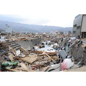
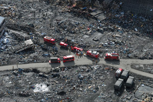
最大震度7を観測、大津波を北海道地方、東北地方、関東地方の太平洋沿岸で観測、死者・行方不明者2万人以上の甚大な被害が生じた。「想定外」という言葉がマスコミを賑わした、日本の英知を集めた地震の専門家達でも全く予見できない大震災が発生したのである。
2.地震ハザードステーション(J-SHIS)
防災に関する科学技術の研究を行う、文部科学省所管の「国立研究開発法人」である「防災科学技術研究所」(略称:防災科研「NIED」)という組織がある。1963年4月、当時の「科学技術庁」の附属機関として設立された「国立防災科学技術センター」に淵源を持つ、防災に関する科学技術の研究を行う機関であり、本部は茨城県つくば市にあるが、全国各地に実験施設や観測施設を所有している。
この「防災科研(NIED)」のホームページにある「J-SHIS:地震ハザードステーション」は秀逸なものである。「主要活断層帯」、「その他活断層帯」、「海溝型地震震源断層」、「海溝型地震発生領域」、「主要活断層帯地表トレース」等に関して、全国マップの中でそれらが詳述されている。
さらに、地震による影響を受ける地域を、今後30年間で「震度5弱以上」、「震度5強以上」、「震度6弱以上」、「震度6強以上」他、それぞれの揺れに見舞われる確率の分布図が一目瞭然、地震リスクによって自社に及ぶ影響が推測できるものとなっている。●「防災科研(NIED)」J-SHIS:地震ハザードステーション・マップ
3.自社の地震リスクを調べる
東日本大震災の僅か2日前であっても、また日本の地震研究を代表するような専門家達が予見できないのが地震の発生リスクである。当然、これを予見することは一般企業人にとっては、全く不可能なことであろう。しかし、「万が一大地震が発生した場合の対応」を検討して、「対応策を決めておくこと」はできるのではないだろうか。地震リスクのリスクマネジメントである。
自分の会社の事務所建物、工場設備等が地震の揺れや、津波リスクにどう曝されているかを予め検証して、対応策を入念に練って、策定しておくことは「万が一への備え」としては非常に重要なことになるであろう。
例えば、上記の「J-SHIS Map」を開き、「震源断層」ボックスの「主要活断層帯」にチェックを入れてみると地図上には主要活断層帯の位置が表示される。そして、「主要活断層帯」のなかで知りたい断層をクリックするとその断層に関する情報が表示される。そして、断層名のリンクをクリックすると「地震調査研究推進本部」による長期評価が表示され、「想定地震地図」タブをクリックすると、想定地震が発生した場合の地震の振動の強さが表示される。
全国に事業所がある企業であれば、「全国地震動予測地図」を見ると、将来発生する危険性のある地震による揺れを予測、その結果を示しているので、全国レベルの地震リスクマネジメントに資するものとなるものである。
4.南海トラフ地震
昨年暮れから、日本列島周辺では大きな地震が相次いでいる。今年に入ってもその傾向に変化は無い。そんななか、今最も懸念されている「大規模な地震」がある。東海から九州の沿岸に広がる「南海トラフ」と呼ばれるプレートの沈み込み帯を震源域として、今後30年間に70~80%の確率で起きるとされる巨大地震である。最大マグニチュード9、最大震度7の激しい揺れと、10メートル、ところによっては30メートルを超える巨大津波が各地を襲い、東京、大阪、名古屋で都市機能が麻痺させる可能性があると言われるものである。
コロナウイルスによる新型インフルエンザの関係もあってか、このところ「南海トラフ地震」についての報道はあまりされていないように感じる。また、「ネットやメディアに出てくる専門家達」の意見でも「切迫した状況ではない」という報道が散見される。しかし、冒頭に記したとおり、東日本大震災は、その2日前であっても日本の地震研究を代表するような専門家達が「予見できなかった」のである。
南海トラフ地震の損害予測は、「地震後20年にわたる長期的な経済損失は1410兆円に及ぶ可能性がある」とされている。犠牲者は、津波や建物の倒壊、火災による犠牲者を含めると最悪32万人にものぼると予測される、まさに「国難」ともいうべき大災害であるといわれている。
政府は去年11月、南海トラフ巨大地震の損害を少しでも減らそうと新たな制度を導入した。南海トラフの震源域周辺で何らかの異常な現象が発生、「今後大規模な地震の発生可能性が通常より高まっている」と判断された場合、それをいち早く「臨時情報」として伝えるというものである。
たとえば、①「南海トラフに横たわる大きな想定震源域の片側半分がずれ動き、マグニチュード8クラスの地震が発生した場合、まだずれ動いていない残りの震源域でも大規模な地震が発生する可能性が高まっている」、また②「想定震源域の一部でマグニチュード7クラスの地震が発生した場合、引き続いて巨大地震が発生する可能性が高まっている」、このような一歩踏み込んだ情報の伝達をおこなうというものである。巨大地震発生の可能性が高まっていることを事前に一早く伝えることで、自治体や住民、企業などに備えを促し、その後実際に巨大地震が起きた際の被害を減らすことが目的である。
しかし、東日本大震災のように、「巨大地震の前兆とみられるような現象が必ずしも起きない地震」もある。異常な現象が何も観測されないまま、突然巨大震災が起きるのである。ただ、前述の2つの例は、過去大地震で実際に発生したものと言われている。
①の「震源域の片側半分で大地震が起き、その後、残りの領域でも大地震が起きる」ケース。これまで起きた南海トラフ大地震では、その多くが「2つの大地震が時間差を置いて発生」している。160年前に起きた「南海トラフ地震」では、これら2つの巨大地震が発生した時間差は「32時間だった」とされている。
また、1944年12月7日に起きたが、太平洋戦争中で報道管制が引かれ「『隠された』と言われる『昭和東南海地震』」では、まず震源域の東半分でマグニチュード8クラスの地震が発生、その2年後、震源域の西半分でマグニチュード8クラスの大地震が発生した。
「敵を利する」と日本政府は、必死になってこの「昭和東南海地震」発生のニュースを隠蔽した。日本のどの新聞にも詳しく掲載されていなかったにもかかわらず、地震の震源地、被害状況は、翌日12月8日付「ニューヨーク・タイムズ」には具に掲載されていたのである。
②の「巨大地震の前に、震源域の一部で小さな地震が起き、引き続いて大規模な地震が起きる」ケース。これは、南海トラフでは過去に確認されていないようであるが、東日本大震災の時には、マグニチュード9の巨大地震の2日前、震源域でマグニチュード7.3の地震が発生していたのである。
今回のまとめ
私たちは、今まさに、未知なる新型コロナウイルスの感染拡大に直面している。この20年間で、2002年から2003年に掛けてのSARS(サーズ:重症急性呼吸器症候群)、2012年からのMERS(マーズ:中東呼吸器症候群)と2度の感染症の大流行に遭遇した経験を今回活かせているのか、果たして備えは十分だったのか、見えてくる課題は何なのか。
東日本大震災から9年、首都圏直下、南海トラフという大震災に対しては、「専門家が予見できないから」ということで済ませることは到底できない。昨日の地震も日本海側で起きているところから「東日本大震災の直接の余震」ではないことが分かる。
地震リスクに囲まれているのが日本である。自らができることを一つ一つ着実に検証、実行していくことが問われているのではないだろうか。リスクマネジメント、危機管理のあり方を具に検証して「想定外」に備えていかなければならない事態ではないだろうか。キャプティブの設立に入れた本格的なリスクマネジメントをするときであると考えている。
執筆・翻訳者:羽谷 信一郎
English Translation
Risk Management 26 -Foreshock of the Great East Japan Earthquake-Earthquake Hazard Station (J-SHIS)
As Japan and the rest of the world grapples with the threat of a new strain of coronavirus and influenza, the earthquake in New Zealand and the volcanic eruption in Indonesia have reminded us of the great risk to Japan, which is also riding on the Pacific Plate.
Nine years after the Great East Japan Earthquake, the number of evacuees is still reported to be over 40,000, and two days after the government-sponsored memorial ceremony for the ninth anniversary of the Great East Japan Earthquake was cancelled due to a new strain of coronavirus, an earthquake of intensity 5+ was recorded at 2:18 a.m. yesterday, March 13, 2020, in Noto, Ishikawa, with an epicenter 10 kilometers deep, was of a magnitude of 5.4 on the Richter scale, in the Noto region of Ishikawa Prefecture.
1. Earthquake Research Institute, Government of Japan, “Monthly Report, February 2011”
The Earthquake Research Committee of the Earthquake Research Division of the Japanese government released its “Monthly Report for February 2011” on March 9, 2011.
In the section “(2) Tohoku Region” of “2.Seismic activity by region “
・On February 10, an earthquake with a magnitude of 5.4 on the Richter scale occurred at a depth of about 50 km off the coast of Fukushima Prefecture. The earthquake was of a reverse fault type with a pressure axis in the west-northwest-east-southeast direction, and occurred at the boundary between the Pacific plate and the land plate.
・A magnitude 5.2 earthquake occurred at a depth of about 45 km off the coast of Fukushima Prefecture on February 27, 2011. The earthquake was of the reverse fault type with a pressure axis in the west-northwest-east-southeast direction, and occurred at the boundary between the Pacific plate and the land plate.
Then, on the “Supplementary Explanation for the Assessment of Earthquake Activity in February 2011” page, in the section “(2) Tohoku Region” of “2.Seismic activity by region.”
There was a coherent seismic activity off the coast of Sanriku, with four earthquakes of magnitude 5.0 or greater since 13 February. The largest was a 5.5-magnitude earthquake that occurred on 16 February. All of the seismic mechanisms are reverse fault-type earthquakes with a pressure axis in the west-northwest-east-southeast direction, which occurred at the boundary of the Pacific plate and the land plate.
Nowhere in them is there any mention of “predicting a great earthquake”. Then, on March 11, two days after the announcement, a magnitude 9.0 earthquake struck off the coast of Sanriku.
A maximum intensity of 7 on the Japanese scale was recorded, and a massive tsunami was felt off the Pacific coast of Hokkaido, Tohoku and Kanto, leaving more than 20,000 people dead or missing and causing extensive damage. “Unexpected” was the word that dominated the mass media, and even Japan’s most eminent earthquake experts could not have foreseen this disaster.
2. Earthquake Hazard Station (J-SHIS)
The National Research Institute for Earth Science and Disaster Resilience, a national research and development corporation under the Ministry of Education, Culture, Sports, Science and Technology (MEXT), was established in April 1963 , which was affiliated with the Science and Technology Agency, to carry out research on science and technology for disaster prevention, headquartered in Tsukuba City, Ibaraki Prefecture, has experimental and observational facilities all over Japan.
The National Research Institute for Earth Science and Disaster Resilience (NIED) has an excellent website called J-SHIS: Earthquake Hazard Stations. The “Major Active Fault Zones”, “Other Active Fault Zones”, “Trench-Type Earthquake Source Faults”, “Trench-Type Earthquake Regions”, “Surface Traces of Major Active Fault Zones”, etc. are described in detail in the national map.
In addition, it also provides a clear map of the probability of being affected by earthquakes over the next 30 years, including “seismic intensity of 5 weak or more”, “seismic intensity of 5 strong or more”, “seismic intensity of 6 weak or more”, “seismic intensity of 6 strong or more”, making it possible to estimate the impact of earthquake risk on the company. J-SHIS: Earthquake Hazard Station Map by The National Research Institute for Earth Science and Disaster Resilience (NIED).
3. Examine your company’s earthquake risk
Even just two days before the Great East Japan Earthquake, what the leading experts in seismic research in Japan could not have foreseen is the risk of an earthquake. It would be impossible for the average person to foresee this. However, it is possible to consider “what to do in the unlikely event of a major earthquake” and decide on “how to respond”. This is the risk management of earthquake risk.
It is very important to examine in advance how your company’s office, plant and equipment are exposed to earthquake and tsunami risks, and then carefully plan and prepare countermeasures.
For example, open the “J-SHIS Map” and check the “Major Active Faults” in the “Source Fault” box, and the location of major active faults will be shown on the map. If you click on a fault in the “Major Active Fault Zone”, the information about the fault will be displayed on the map. If you click on the link of the fault, the long term evaluation by the “Earthquake Research and Development Directorate” is displayed, and if you click on the “Earthquake Map” tab, the intensity of earthquake oscillation in case of a major earthquake is displayed.
If your company has offices all over Japan, the National Earthquake Motion Prediction Map will show you the results of the predictions of possible future earthquakes, contributing to earthquake risk management on a national level.
4. Nankai Trough Earthquake
Since the end of last year, there has been a series of major earthquakes in and around the Japanese islands. This year there has been no change in this trend. However, there is one major earthquake that is causing the greatest concern. The epicenter is in the subduction zone of the Nankai Trough, which stretches from Tokai region to the coast of Kyushu, and there is a 70-80% probability of a major earthquake occurring within the next 30 years. A violent quake with a maximum magnitude of 9 on the Richter scale and a maximum intensity of 7 on the Japanese seismic scale, followed by a huge tsunami of 10 meters and in some cases more than 30 meters, is said to be capable of paralyzing the cities of Tokyo, Osaka and Nagoya.
Perhaps in part due to the new strains of coronavirus flu, there has not been much coverage of the Nankai Trough earthquake. Also, the opinions of experts appearing on the Internet and in the media are scattered across the board, and some of them say that the situation is not urgent. However, as I mentioned at the beginning of this article, even two days before the Great East Japan Earthquake, Japan’s leading earthquake research experts could not have foreseen it.
Estimates of the damage from the Nankai Trough earthquake say that “long-term economic losses over the 20 years following the quake could be as high as 1,410 trillion yen”. The death toll is expected to rise to 320,000 if tsunamis, collapsed buildings and fires are included, making it a national disaster of epic proportions, it said.
Last November, the government introduced a new system in an attempt to reduce the damage caused by the Nankai Trough earthquake by as much as possible. If something unusual occurs in the area around the epicenter of the Nankai Trough and it is judged that “the likelihood of a large-scale earthquake is higher than usual”, the government will promptly report this information as “a special bulletin”.
For example, 1) “If one half of the large expected epicenter area lying in the Nankai Trough moves out of alignment and a magnitude 8 earthquake occurs, the possibility of a large earthquake occurring in the remaining epicenter area that has not yet moved out of alignment is increasing,” and 2) “If a magnitude 7 earthquake occurs in a part of the expected epicenter area, the possibility of a large earthquake occurring in the rest of the area is increasing. The purpose of this system is to encourage local governments, residents and businesses to prepare for a major earthquake by informing them in advance that the possibility of a major earthquake is increasing, in order to reduce the damage caused by a subsequent major earthquake.
However, some earthquakes, such as the Great East Japan Earthquake, do not necessarily have the phenomena that would be seen as precursors to a major earthquake. In other cases, huge earthquakes occur suddenly without any unusual phenomena being observed. However, the above two examples are said to have actually occurred in past large earthquakes.
In the first case, a major earthquake occurs in one half of the epicenter area, and then a major earthquake occurs in the rest of the region. Most of the major Nankai Trough earthquakes that have occurred in the past have involved two major earthquakes with a time gap between them; in the case of the Nankai Trough earthquake, which occurred 160 years ago, the time gap between the two major earthquakes was 32 hours.
In the “Showa-Tonankai Earthquake,” which occurred on December 7, 1944, but was “hidden” because of the press control during the Pacific War, an eight-magnitude earthquake first struck in the eastern half of the epicenter area, and two years later, a massive eight-magnitude earthquake struck in the western half of the epicenter area.
The Japanese government, in an effort to “play to the enemy’s advantage,” covered up the news of this “Showa-Tonankai earthquake. Although none of the Japanese newspapers reported the earthquake in detail, the epicenter of the quake and the extent of the damage were fully reported in the “New York Times” on December 8, the next day.
In case 2), “a large earthquake is preceded by a small quake in a part of the epicenter area, followed by a large one”. This seems not to have been seen in the past in the Nankai Trough, but in the case of the Great East Japan Earthquake, a 7.3-magnitude earthquake occurred in the epicenter area two days before the 9-magnitude earthquake.
Summary of this issue
We are now facing the spread of an unknown new coronavirus. Over the past 20 years, we have experienced two major epidemics of infectious diseases, SARS (Severe Acute Respiratory Syndrome) from 2002 to 2003 and MERS (Middle East Respiratory Syndrome) from 2012.
Nine years after the Great East Japan Earthquake, it is impossible to respond to a major earthquake, such as the one that hit the Tokyo metropolitan area and the Nankai Trough, by simply saying that there is nothing that can be done because the experts cannot foresee it. Yesterday’s earthquake, which occurred on the Sea of Japan side, was not a direct aftershock of the Great East Japan Earthquake.
Japan is surrounded by earthquake risks. We need to do what we can do, one thing at a time, to steadily verify and implement what we can do. This is a situation that requires us to examine our risk management and crisis management systems in concrete terms and prepare for the unexpected. I believe that it is time for full-scale risk management, including the establishment of captives.
Author/translator: Shinichiro Hatani