
キャプティブ 2022.03.31
RM70「地名に潜むリスク」へ備えるキャプティブ 5(「東海湖」名古屋)
目次
Copyright © Shinichiro Hatani 2022 All rights reserved
For those who prefer to read this column in English, the Japanese text is followed by a British English translation, so please scroll down to the bottom of the Japanese text.
日本人が愛して止まない「陶磁器」。数多くある陶磁器の郷のなかで、「日本三大陶磁器の郷」と言われているのは、佐賀県有田町を中心に焼かれる陶磁器であるが、その搬出、輸送が伊万里港からなされていたため「伊万里焼」とも呼ばれる「有田焼」、陶磁器生産量日本一土岐市を中心に制作されている「美濃焼」、そして陶磁器のことを一般的に「瀬戸物」と呼ぶように知名度が高い「瀬戸焼」である。
「中世、陶磁器の細工に長けていた中国、朝鮮半島に近い場所に、良質の粘土を得ることができた『有田』が存在していた」ということで著名な「陶磁器の郷」となったということは理解できるが、なぜ、九州を遠く離れた東海地方に、「三つのうち二つの有名な陶磁器の郷が存在した」のであろうか。その背景には、東海地方の地層構造が深く関係している。
「陶土」として使える良質の粘土層は、古代、湖や沼であった地が隆起して丘陵地になっている場所、また古代に川底であった河岸段丘の土地で得られることが多い。その上流域から、風化珪石や長石等の諸鉱物を含んだ岩石が砕かれて流入、沈殿、堆積して粘土層が生成されているからである。
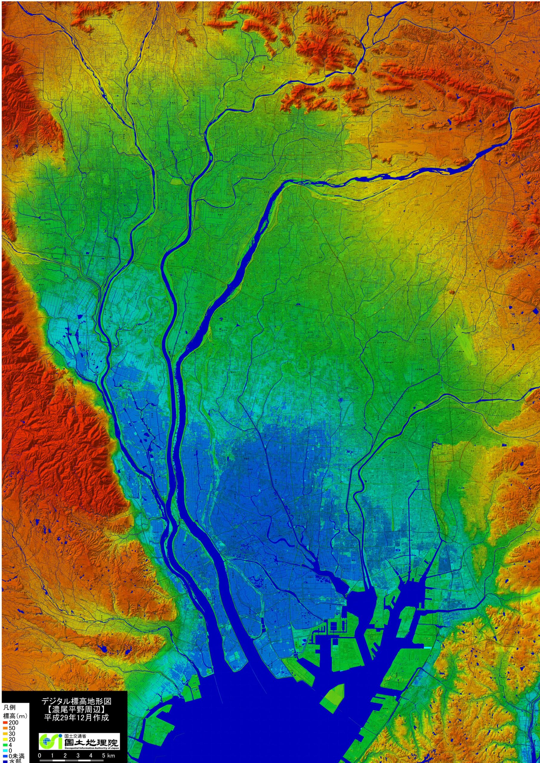
(出典:「国土地理院」,「デジタル標高地形図」(濃尾平野周辺))
上図は「国土地理院」の「デジタル標高地形図」(濃尾平野周辺)から引用した地図である。この地図で明らかなように全面低地である。「濃青色」の水域から陸地に入っても、「青色」の「標高0m未満地帯」、「水色」の「0m地帯」、そして「緑色」の「4m地帯」の低地が全域に広がっている。
「青色」の地域は「蟹江三角州」、北東方向、地図では右上の山地、犬山市の手前付近まで、北西方向では養老山地までの岐阜市、大垣市あたりまでの広大な「緑色」の一帯は木曽川、長良川、揖斐川の氾濫によってできた「一宮氾濫平野」であり、犬山市付近は木曽川によってできた「犬山扇状地」と呼ばれている。
名古屋市のホームページにある「生物多様性2050なごや戦略」の第2章「自然が創り人が造った名古屋」によると、「青色」「水色」そして「緑色」の一帯は、「650万~100万年前には伊勢湾北部や北勢・濃尾地域に湖沼や低湿地(東海湖)が広がる」と記されている。つまり、数百万年前には、伊勢湾北部から濃尾平野に至る現在の琵琶湖の何倍もある巨大な湖、「東海湖」が存在したということである。
「緑色」に近接する「黄色」から「黄土色」の地帯のなかに、現在の瀬戸、多治見、土岐がある。東海湖には、周りの山や丘から花崗岩の白色の細粒が流れ込み湖底に、陶磁器の原料、飲食器、洗面台やトイレといった衛生陶器等の製作には不可欠な最高品質の「白い粘土質」が形成されていった。瀬戸、多治見、土岐の地が「陶磁器の郷」となった背景である。
その後の地殻変動によって東海湖は姿を消したと言われているが、「湖底」に堆積した粘土は焼き物に欠かせない原料となった「東海湖の置き土産」である。
1.名古屋市直下の断層
「名古屋市のホームページ」の「名古屋市付近に推定されている断層に関する報告書について」のページには、冒頭、「1 調査の背景と目的」「平成28年4月に発生した熊本地震が活断層によるものと考えられると評価されたことを受けて、名古屋市においても市域に推定されている断層について調査するため、名古屋市防災会議地震災害対策部会を設置しました。」との記述に続き、下図が掲載されている。
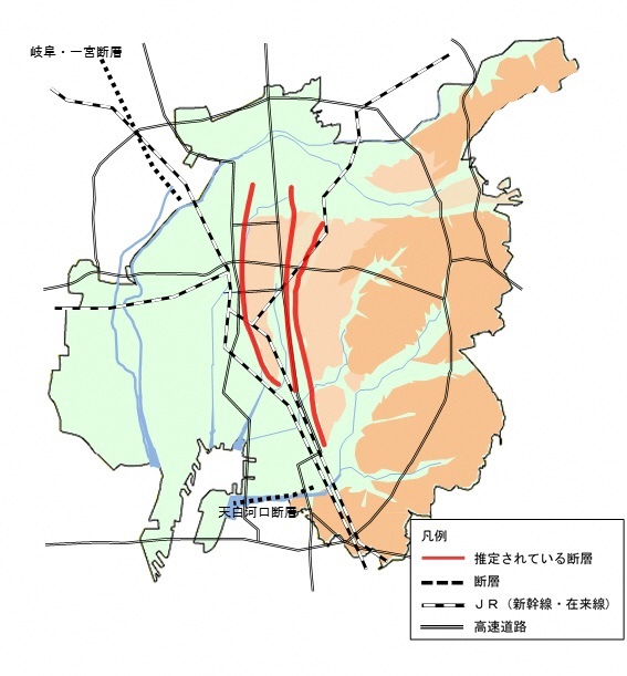
(出典:名古屋市ホームページ「名古屋市付近に推定されている断層に関する報告書について」)
上図にある赤い線で描かれた3つの断層は、地図と照らし合わせると、左の線が①JR名古屋駅から熱田神宮までの断層、真ん中が②熱田台地北西端に名古屋城、南西端に熱田神宮が所在する名古屋城から熱田神宮までの断層、そして右側にあるのが③鶴舞公園から笠寺観音までの断層と解る。
同ホームページは次の言葉で結ばれている。
4 今後の対策
今回の調査結果として、○推定されている活断層の存在について
撓曲(とうきょく)を起こす断層の可能性は否定できないため、市域全域での対策が必要である。
○耐震対策等の重要性について
熊本地震で建築物の被害が大きかった益城町中心部において昭和56年6月から平成12年5月に建てられた木造建築物で倒壊・崩壊は8.7%、平成12年6 月以降に建てられた木造建築物で倒壊・崩壊は2.2%となっている。
直下型地震では緊急地震速報が間に合わない可能性があり、命を守るための対策が必要であるとのことから、引き続き建築物の耐震対策、家具等の転倒・落下防止対策等を推進してまいります。
この3つの断層が動いて起きる地震は「断層型地震」であり、都市直下で起きるため「阪神・淡路大震災」のように地震の規模(マグニチュード)は「海溝型地震」に比べて小さくても甚大な被害になる可能性が高い特徴を持っている。
「断層型地震」はその断層が動くことによって引き起こされるとされているが、「断層型地震」は、「海溝型地震」である「南海トラフ巨大地震」や「東海地震」と連動して起きる可能性がある。巨大な「海溝型地震」の直前、直後には、「海溝型地震」によって動きつつある、また動いたプレートのエネルギーが「断層」を動かすからである。
1944年12月に起きた「昭和東南海地震」のちょうど2年後、1946年12月に「昭和南海地震」が起きたが、その1年前には「断層型地震」であるM6.8の三河地震が起きていた。本コラムの「CS13『ながい旅』(岡田 資 陸軍中将)」に以下のように記した。
昭和東南海地震は、海洋プレートの沈み込みに伴い発生した大地震であり、さらに授業・勤務時間帯に重なったこともあり、学校や軍需工場等を中心に犠牲者は1,223人にのぼった。その37日後、昭和東南海地震に誘発されて起きた三河地震は、活断層が28Kmに渡って動いた内陸直下型であったため、被害の程度は昭和東南海地震を上回る規模で、犠牲者は2,306人にも達したのである。
「名古屋市直下の3つの断層」のうち、「①JR名古屋駅から熱田神宮までの断層」は、1891年10月濃尾地方で起きたマグニチュード8.0とされる、日本の歴史上最大の「断層型地震」の時に動いた断層である。
南海トラフ巨大地震、東海地震等の「海溝型地震」による「津波被害」のみを想定するのではなく、名古屋市直下でも「断層型地震」を引き起す可能性が十分にあると考える備えが必要であろう。
2.天正地震
本年、2022年1月31日、本コラムに投稿した「RM68地名に潜むリスク 3(『干拓地』東京)」で引用した「歴史から探る21世紀の巨大地震(朝日新書 朝日新聞出版刊)」、その著者である産業技術総合研究所(産総研)名誉リサーチャー寒川旭(さんがわ あきら)氏の論文、「天正地震の地震考古学」(活断層研究 35号 67〜73 2011)には、1586年1月18日(天正13年11月29日)に中部から近畿にかけて「天正地震」と呼ばれる巨大な地震が発生したことについて、以下のように「終わりに」に記されている。
天正地震は,日本列島で発生した内陸地震の中でも最大級の規模を持つと考えられる.この地震を引き起こした活断層として,庄川断層帯・阿寺断層帯・養老-桑名-四日市断層帯が候補に挙がっている.この地震で被害を被った地域が広範囲に及び,明瞭な時間差が認められていないことから,これらの断層帯がほぼ同時,あるいは短い間隔で活動したと考えられる.
また,この地震の10年後には,京阪神・淡路地域に大きな被害を与える伏見地震が発生しており,この地震の前の数日間に別府湾で大地震があり,四国を横断する中央構造線断層帯も活動した可能性が高いと考えられている.このように,大きな内陸地震が短い期間に連動したという事実は将来の防災を考える上にも重要であり,これらの地震についてさらに詳しい研究が望まれる.
一方,天正地震については,戦国乱世が終結して天下が統一されようとした時期に起きた大震災として,地震が歴史に与えた影響を考える上でも大きな意味を持っている。
戦国時代であったためか、この天正地震に関しての文献は非常に少なく、震源及び地震の規模(マグニチュード)についても推定できるデータが残っていないが、中部地方では城や城下町が大きな被害を受けた。なかでも、岐阜県飛騨地方では、標高1600mを超える帰雲山で大きな山崩れが発生、帰雲城、城下町の大半が埋没、大きな人的・物的被害が発生、そのため領主内ヶ島氏一族は滅亡の憂き目に遭った。また、現在の「清須市」もほとんどの地域が海抜5m以下の低地であるが、織田信長が出てその後も長らく尾張領主の居城であった「清洲城」は、その地名の由来からも庄内川による「洲」と推測できるが、この地震によって大規模な「液状化」が発生したようである。
愛知県「蟹江町」のホームページには、以下のように「蟹江」の由来が記されている。
▼「カニエ」という地名のおこり
「カニエ」と名づけられた地名が、初めて文献に表されたのは、1215年(建保3年)「水野家文書」の中からといわれています。そのころの蟹江は、一面海に囲まれた土地で、「蟹江郷」とか、「富吉荘」という名称で呼ばれていましたが、海辺に柳が茂り、多くの蟹が生息していたことから「蟹江」と呼ばれるようになったと伝えられます。
蟹江町が属している「海部郡」については、「古代地名語源辞典」(楠原佑介 [他]編著 東京堂出版刊)によると、「漁業、航海を中心とした職業的品部、『海人部(あまのべ)』に由来する地名」とあり、尾張国(愛知)以外に豊後国(大分)、紀伊国(和歌山)、壱岐国(壱岐対馬)にある。また、同書には「『日本書紀』応神記に海人部および山守部を令して定めた」とあり当時から海軍の必要であったことが伺える。これらのことから、古代この地方は、「水、海」に非常に関係の深い場所であったということが解る。
3.縄文海進
地球軌道の変化によると考えられているが、氷河期の終わりとともに地球の気温は継続的に上昇、氷が融け海洋に流出していった。北半球の中高緯度の多くが最も温暖な時期を迎えたのは、「ヒプシサーマル(hypsithermal)」、日本語では「完新世の気候最温暖期」と呼ばれる時期、現在から7,000年~5,000年前の時期であった。
このヒプシサーマルの時期、氷河は北米やヨーロッパから姿を消し、グリーンランドと南極大陸に残るのみとなった。この氷河の融水の流出は、氷河があった場所からはその重みが無くなり、一方海底には新たな重みが加わり、結果、陸上では隆起運動、海洋では沈降運動が起き始める結果をもたらし、その動きは現在でも続いている。この温暖化によって、地球各地では、湿潤化して森林が増加、草原の減少が起き、マンモスなど大型哺乳類を絶滅させることになったとされている。
現在のインドネシアやフィリピンなどがユーラシア大陸から分離して島となり、北米大陸もユーラシア大陸から分離、9600年前ころ、ドーバー海峡が出現、グレート・ブリテン島が大陸から切り離された時期である。
このヒプシサーマルの時期は、「縄文時代」の時期と重なり、日本列島のように、氷河から遠く離れた地域では海水面が大きく上昇、ピーク時である約6,000年前まで上昇、海水面が5メートルほど高くなり、「海が内陸部に進む」ことから「縄文海進」と呼ばれている。
冒頭の「国土地理院」の「デジタル標高地形図」(濃尾平野周辺)から、縄文時代の海岸線の位置を推測すると、「濃青色」の水域、「青色」の標高0m未満地帯、「水色」の0m地帯、そして「緑色」の4m地帯、これら全域が「縄文時代には海であった」ということになる。
つまり、名古屋市は熱田台地、御器所台地等の台地及び東の東部丘陵地帯を除く全地域、北は岐阜市の山沿いまで、北東は各務ヶ原市・犬山市の山沿いまで、北西は大垣市のほぼ全域まで、そして西は養老山地まで、この広大な一帯が海であったことが推測できる。
JR名古屋駅の標高は約2.2m、栄の市役所の標高は約12.4m、熱田台地に立つ名古屋城の標高でさえ約14mと全般的に低地である。また、その低地を形成している沖積層の特徴は「軟弱な地盤」である。「低地」と「軟弱な地盤」という自然災害に対する二つの大きなリスクと戦うため、先人達は、熱田台地の南端に熱田神宮、中央部に東別院、北端には名古屋城を建てていたのである。先人の「リスクマネジメント」であった。
その後、河川の土砂堆積によって海岸線は徐々に南下、戦国時代には「中川区」までが陸地となり、その後、干拓が進んで今の名古屋市が形成されたが、名古屋市の西側は「海抜の低い土地」であり、「津波」の被害に遭いやすい地形となっている。それを示すように、名古屋市のホームページ(「防災・危機管理」の箇所)には次のような記述がある。
南海トラフ巨大地震が発生した場合に津波浸水が予想される、中村区、瑞穂区、熱田区、中川区、港区、南区及び緑区に海抜を表示し、普段からの防災意識の高揚と発災時の迅速な避難の目安としていただけるよう、海抜表示を実施しています。
こういう津波による外水氾濫の危険姓が高い地域でとりわけ重要な「地震保険」の補償分野が「地震による事業の継続に問題が起き、事業収益が落ち込むリスク」に対応する補償、「事業中断リスク」(英文では「Business Interruption(ビジネス・インタラプション):BI」である。
自社の掛けている地震保険にこの補償が入っているかどうかによって、災害復旧への金銭的な支えは大きく異なることに注意が必要である。「地震保険はどこでも同じ」ではないからである。
4.地名に示されるリスクの伝承
「名古屋市熱田区」のホームページには、同地の地名の伝承に関して以下のように記されている。
木之免(きのめ)
昔、この土地は海中にあったが、中世末ころ、築き立てた。熱田祝詞師・田島丹後守の控え地となり、毎年、薪を神宮に調達するのを役務としたので、この名がついたという。
神戸(ごうど)
『名和抄』に愛知郡神戸、『熱田神領目録』(分和3年<1354年>)に高戸郷とあり、のちに神戸村となった。神戸とは、もともと川の渡し場や神社所属の住民の意である。岐阜市の西郊の中山道にも「合渡」宿の地名が残っている。幕末尾張の学者・津田正生は、「神戸は河門とも、船の出入りする所をいうなり」と『名古屋市史地理編』は述べている。
須賀(すか)
熱田の浜に沿った砂地、洲であったところから名付けられた。須賀とは、湿地、水辺の地を指し、横須賀、蜂須賀、大須賀などの地名が各地に残る。
富江(とみえ)
いわゆる旧熱田の湊町地域に属し、江戸期に繁栄したところ。「江」は、入江とか湾口を意味している
他の地域でも「水害リスクを感じる地名」を見ることができた。西区にある「押切」(おしきり)、この「押切」とは、「水によって破損した場所のこと」を指すと言われている。「地名は警告する 日本の災害と地名 谷川健一編 冨山房インターナショナル(刊)」には以下のように記されている。
押切
水が押し切って流れていたところ。名古屋市西区押切町では二〇〇八年八月二十九日の大雨で多くの車が水没した。浸水したのは市内でここだけであった。この付近を笈瀬川(中川の上流)が流れていたが、現在は暗渠である。
中川区にある「荒越町」の「荒越」とは「川が荒れて土手を越えて水が流れ出た場所」のことを言うとされている。ただ、地名に関しては諸説ある場合が多く、明確なもの以外は「自分の目」でリスクを確認することが必要であろう。
今回のまとめ
大化の改新で「律令制」が敷かれる前、古墳時代には地方を支配する地方豪族に対して、「ヤマト王権」が軍事権、裁判権等を与えた「国造」(くにのみやっこ)という官職が存在した。愛知県には、ヤマト王権との密接な関係を持ち大きな勢力を有した尾張国造(おわりのくにのみやつこ)がいた。
そのことを物語るように、愛知には三つの大きな古墳がある。名古屋市の熱田台地南西、熱田神宮公園内にある、愛知の古墳の中で最大、墳丘長151mの「断夫山古墳」(だんぷさんこふん)、二番目の規模の犬山市の台地にある墳丘長123m「青塚古墳」、そして名古屋市守山区の丘陵に立つ墳丘長115mの「白鳥塚古墳」である。
「埋蔵文化財関係統計資料」(平成28年度 平成29年3月 文化庁文化財部記念物課)によると、愛知県には3101基の古墳が県内各地にあるが、「古墳の規模=埋葬者の権威」という点から見ると、これら最大の古墳3基が存在している場所は、いずれも台地、高地、丘陵であり、「水災」に遭わないことを目的として建築場所が決められたと推測できる。
「地震の予知はできない」と言われているが、「自社のリスクマネジメント」のためには、こういうことを具に見る「眼」も必要ではないだろうか。「工場、事業所のある地名の由来(歴史)」を調べることもリスクマネジメントに大いに資するからである。また「工場、事業所の近くに何が存在しているか」を調べることも、「リスクマネジメントの道標」になるのではないだろうか。古くから存在している「神社・仏閣」があるか、そのもっと前から存在している古墳の有無、状況の確認も重要なリスクマネジメントになるであろう。
前述の産業技術総合研究所(産総研)名誉リサーチャー寒川旭氏が著わした「歴史から探る21世紀の巨大地震(朝日新書 朝日新聞出版刊)」には、「文献や大地に刻まれている痕跡を分析することによって、その土地での過去の地震の頻度や大きさがわかってくる。」との記述がある。
未曾有の被害を受けた2011年の東日本大震災から10年が経過した。「南海トラフ巨大地震」、「千島・日本海溝地震」と巨大地震が日本列島に襲いかかってくる時代を迎えている。地震リスクへの対応は「待った無し」である。しかしながら、「地震保険への企業の加入状況は低い状態が未だに続いている」のが現状である。
「巨大地震に備える態勢の構築」が喫緊の課題であることは誰しも認めているところである。キャプティブを設立することによって海外の再保険会社から、廉価で広範な補償を得て備えを図ることが重要ではないだろうか。いまほど、キャプティブの存在意義が求められている時は無いと感じている。
キャプティブの設立までには、通常数ヶ月以上掛かるという現実がある。大地震が起きてから、「やっておけば良かった」と後悔しないためにも、一刻も早く取り組むことが肝要ではないかと冒頭のデジタル標高地形図を見て感じた。今から10年前、2012年8月、国の「有識者会議」が発表した「南海トラフ巨大地震の被害想定」では、液状化リスクだけで、愛知県では約2万3000棟が全壊すると発表されているからである。
執筆・翻訳者:羽谷 信一郎
English Translation
Risk Management (RM) 70 – Captives for “Risk in place names” 5 (“Lake Tokai”, Nagoya)
Japanese people love ceramics. Among the many ceramic villages in Japan, Arita is known as one of the “Three Great Ceramic Villages of Japan”, which is also known as “Imari-yaki” because it was transported from the port of Imari in Saga Prefecture, Mino-yaki, which is produced mainly in Toki City, the largest producer of ceramics in Japan, and Seto-yaki, which is well known as “Setomono” in Japan.
It is understandable that “Arita” became a famous “ceramic town” in the Middle Ages because it was located close to China and the Korean peninsula, where there were good clay resources for making ceramics. But why did two of the three famous ceramic villages exist in the Tokai region, far from Kyushu? The reason for this is deeply related to the geological structure of the Tokai region.
High quality clay layers that can be used as “pottery clay” are often found in uplifted hills where there used to be lakes and swamps in ancient times, and in river terraces where there used to be river bottoms in ancient times. This is because rocks containing minerals such as weathered silica and feldspar were crushed, Sedimented and deposited from the upper reaches of the river to form the clay layer.
The above map is taken from the “Digital Elevation Topographic Map” (around the Nobi Plain) of the Geographical Survey Institute. In this map, even if it enters the land from the water area of the “dark blue”, the “blue” elevation less than 0m zone, the “light blue” 0m zone, and the “green” 4m zone, the lowland spreads all over. The “blue” area is the “Kanie delta”, the mountainous area on the upper right of the map in the north-east direction, up to just before Inuyama City, and the area around Gifu City and Ogaki City up to the Yoro Mountains in the north-west. The area around Inuyama City is known as the “Inuyama alluvial fan”, which was formed by the Kiso River.
According to Chapter 2 “Nagoya, created by nature and built by man” of “Biodiversity 2050 Nagoya Strategy” on the Nagoya City website, this “blue”, “light blue” and “green” area was “an area of lakes, marshes and low marshes ( Lake Tokai) in the northern part of Ise Bay and the Hokusei and Nobuo areas 6.5 to 1 million years ago”. This means that millions of years ago, there existed a huge lake called ” Lake Tokai “, many times larger than the present Lake Biwa, stretching from the northern part of Ise Bay to the Nobuo Plain.
In the “yellow” to “ochre” zone bordering the “green” lake, there are today’s Seto, Tajimi and Toki. The white granite grains from the surrounding mountains and hills flowed into Lake Tokai and formed the highest quality “white clay” at the bottom of the lake, which is essential for the manufacture of ceramics, eating and drinking utensils, and sanitary ware such as washbasins and toilets. This is the reason why Seto, Tajimi and Toki became the “home of ceramics”. Later, it is said that Lake Tokai disappeared due to tectonic movements, but the clay deposited in the “lake bed” became an essential raw material for pottery.
1. Fault lines directly under Nagoya City
On the Nagoya City website, there is a page entitled “Report on faults estimated to be in the vicinity of Nagoya City”, which begins: “1. Background and purpose of the survey” and “Following the assessment that the Kumamoto earthquake that occurred in April 2016 was thought to be caused by an active fault, we decided to survey the faults estimated to be in the Nagoya City area. In response to this, Nagoya City established the Nagoya City Disaster Prevention Council’s Earthquake Disaster Prevention Subcommittee to investigate the faults estimated to exist in the city.
(Source: Nagoya City website, “Report on Faults Presumed to Occur Near Nagoya City”)
The three faults shown in the diagram above are (1) the fault from JR Nagoya Station to Atsuta Jingu Shrine, (2) the fault from Nagoya Castle to Atsuta Jingu Shrine, with Nagoya Castle at the northwestern end of the Atsuta Plateau and Atsuta Jingu Shrine at the southwestern end, and (3) the fault from Tsurumai Park to Kasadera Kannon.
The website concludes with the following words.
4 Future measures
The results of this survey are as followsThe existence of the presumed active fault
The possibility of a fault that causes flexure cannot be denied, so countermeasures are necessary throughout the city area.
Importance of earthquake resistance measures
In the central part of Mashiki Town, where buildings were severely damaged by the Kumamoto Earthquake, 8.7% of wooden buildings built between June 1981 and May 2000 collapsed or collapsed, and 2.2% of wooden buildings built after June 2000 collapsed or collapsed.
In the event of a direct earthquake, it is possible that the Earthquake Early Warning System will not be able to be activated in time, and it is necessary to take measures to save lives.
Therefore, we will continue to promote earthquake-resistant measures for buildings and measures to prevent furniture and other items from falling over.
Earthquakes caused by the movement of these three faults alone are called “fault earthquakes”, and because they occur directly beneath cities, they are likely to cause extensive damage even if the magnitude of the earthquake is smaller than that of trench earthquakes, such as the Great Hanshin-Awaji Earthquake.
However, there is no denying the possibility that these fault earthquakes will be linked to the Nankai Trough and Tokai earthquakes, which are trench earthquakes. This is because just before or just after a large “trench-type earthquake”, the energy of the plates moved by the “trench-type earthquake” may well move “faults”. The “Showa Tonankai Earthquake” occurred in December 1944, followed by the “Showa Nankai Earthquake” in December 1946, and the reason for this is that the M6.8 Mikawa earthquake, a “fault-type earthquake”, had occurred one year earlier. I wrote about this in this column, CS13 “Long Journey” (Lieutenant General Tasuku Okada, Army) as follows.
The Showa Tonankai Earthquake was a major earthquake caused by the subduction of an oceanic plate, and because it coincided with school and work hours, the number of casualties, mainly in schools and munitions factories, reached 1,223. Thirty-seven days later, the Mikawa earthquake, which was triggered by the Showa-Tonankai earthquake, was a direct inland earthquake in which active faults moved over a distance of 28 km, and the scale of the damage was greater than that of the Showa-Tonankai earthquake, with 2,306 victims.
Of the aforementioned “faults directly beneath Nagoya City”, “1) the fault from JR Nagoya Station to Atsuta Jingu Shrine” was the fault that moved during the largest “fault-type earthquake” in Japan’s history, which occurred in the Nobi area in October 1891 and is estimated to have measured 8.0 on the Richter scale. It is necessary to be prepared for the possibility that a “trench-type earthquake” such as the Nankai Trough Earthquake or the Tokai Earthquake could trigger a “fault-type earthquake” directly under Nagoya City.
2. Tensho Earthquake
This year, January 31, 2022, in the article “RM68 – Captives for the risk in place names (‘reclaimed land’ Tokyo)” posted in this Column, I cited the article “Huge earthquakes in the 21st century explored from history (Asahi Shinsho, Asahi Shimbun Publications)”, and its author, Akira Sangawa, a researcher emeritus at the National Institute of Advanced Industrial Science and Technology (AIST). In his article, “Seismic Archaeology of the Tensho Earthquake” (Active Fault Research, No. 35, 67-73, 2011), the author, Dr. Akira Sangawa, writes the following about a huge earthquake called the “Tensho Earthquake” that occurred in the Chubu and Kinki regions on January 18, 1586 (November 29, Tensho 13).
The Tensho Earthquake is considered to be one of the largest inland earthquakes to have occurred in the Japanese archipelago. The Shokawa fault zone, the Atera fault zone and the Yoro-Kuwana-Yokaichi fault zone are candidates as the active faults that caused this earthquake. Since the area affected by this earthquake is wide and there is no clear time difference, these fault zones are considered to have acted almost simultaneously or at short intervals.
In addition, 10 years after this earthquake, the Fushimi earthquake occurred, which caused great damage in the Keihanshin-Awaji area. A large earthquake occurred in Beppu Bay a few days before this earthquake, and it is considered highly likely that the Median Tectonic Line fault zone crossing Shikoku was also active. The fact that such large inland earthquakes occurred in such a short period of time is important for disaster prevention in the future.
The Tensho earthquake, on the other hand, is of great significance in terms of the impact of earthquakes on history, as it occurred at a time when the Warring States period was ending and the country was about to be unified.
There are very few documents on the Tensho Earthquake, probably because it was during the Warring States period, and there is no data to estimate the epicentre or the magnitude of the earthquake, but castles and castle towns in the Chubu region were severely damaged. In the Hida area of Gifu Prefecture, a large landslide occurred on Mount Kaerikumoyama, which is over 1,600m above sea level, burying the castle and most of the castle town, causing great human and material damage. This led to the downfall of the Uchigashima clan. In addition, most of the present “Kiyosu City” is also a low-lying area less than 5m above sea level, but “Kiyosu Castle”, which was the residence of the Owari lords for a long time after Nobunaga Oda left the city, seems to have been “liquefied” by this earthquake, although it can be assumed from the origin of its name that it is a “su” caused by the Shonai River.
The town of Kanie, also in Aichi Prefecture, has the following information on its website about the origin of the name “Kanie”.
The origin of the place name “Kanie
The name “Kanie” is said to have first appeared in literature in 1215 in the Mizuno family document. At that time, Kanie was surrounded by the sea and was called “Kanie-go” or “Tomiyoshi-so”, but it is said that the name “Kanie” came from the many crabs living in the willow trees by the sea.
According to the “Etymological Dictionary of Ancient Place Names” (edited by Yusuke Kusuhara [et al.], published by Tokyo Do Publishing), “Ama-gun”, to which the town of Kanie belongs, is “a place name derived from ‘Ama-no-be’, an occupational department focusing on fishing and navigation”, and is found in Bungo Province (Oita), Kii Province (Wakayama), , Kii (Wakayama) and Tsushima Province (Iki). It is also written that “in the Nihon Shoki (Chronicles of Japan), the Ojinki (Records of Ojin), the Ama-no-be and Yama-mori-be were decreed and established”, indicating that there was a need for a navy from that time. The name of the place suggests that the area had a strong connection with water and the sea in ancient times.
3. Jomon transgression
It is thought that changes in the Earth’s orbit caused the temperature of the Earth to rise continuously at the end of the last Ice Age, causing the ice to melt and flow into the oceans. The warmest period for much of the mid to high latitudes of the northern hemisphere was the “hypsithermal”, or Holocene climatic maximum, between 7,000 and 5,000 years ago.
During the Hypsithermal, glaciers disappeared from North America and Europe, leaving only Greenland and Antarctica. The outflow of meltwater from these glaciers removed the weight of the glaciers from where they had been, while adding new weight to the seabed, resulting in uplift movements on land and subsidence movements in the oceans, which continue to this day. This warming has resulted in the wetting of the earth, an increase in forests and a decrease in grasslands, which has led to the extinction of large mammals such as the mammoth.
Today’s Indonesia and the Philippines are islands separated from Eurasia, and the North American continent was also separated from Eurasia, and around 9600 years ago the Strait of Dover appeared, separating the island of Great Britain from the continent.
This period of hypothermia coincided with the Jomon period, when sea levels rose significantly in areas far from glaciers, such as the Japanese archipelago, until they peaked at around 6,000 years ago, raising sea levels by around five metres.
From the Geographical Survey Institute’s Digital Elevation Topographic Map of the area around the Nobo Plain at the beginning of this article, we can infer the location of the coastline during the Jomon period: the “‘dark blue” water area, the ”blue” area with an elevation of less than 0m, the ”light blue” area with an elevation of 0m, and the ”green” area with an elevation of 4m, all of which were seas during the Jomon period.
In other words, the city of Nagoya, excluding the plateaus of the Atsuta and Gokiso plateaus and the eastern hills to the east, and extending north to the mountains of Gifu City, northeast to the mountains of Kakamigahara and Inuyama Cities, northwest to almost all of Ogaki City, and west to the Yoro Mountains, can be assumed to have been a sea. The elevation of JR Nagoya Station is about 2.2m, the elevation of the City Hall in Sakae is about 12.4m, and even the elevation of Nagoya Castle on the Atsuta Plateau is about 14m. To combat these two major risks of natural disasters, our ancestors built Atsuta Shrine at the southern end of the plateau, Higashi Betsuin in the centre and Nagoya Castle at the northern end. This was the “risk management” of our ancestors.
Later, the coastline gradually moved southwards as rivers deposited sand and soil, and by the Warring States period, land had been reclaimed as far as Nakagawa-ku. As an indication of this, the Nagoya City website (under “Disaster Prevention and Risk Management”) has the following statement
In the event of a major earthquake in the Nankai Trough, the elevation of the sea is displayed in Nakamura, Mizuho, Atsuta, Nakagawa, Minato, Minami and Midori wards, where tsunami inundation is expected.
In such areas where the risk of flooding due to tsunamis is high, it is particularly important to ensure that earthquake insurance covers the “risk of business interruption” (Business Interruption: BI in English), which is the risk of loss of business profits due to problems with business continuity caused by earthquakes.
4. The transmission of risk in place names
On the website of “Atsuta-ku, Nagoya City”, I found the following information on the tradition of place names.
Kinome
This land used to be under the sea, but it was built up at the end of the Middle Ages. It became the flamen of Tajima Tango-Kami, a priest of Atsuta, and was named after his annual service of procuring firewood for the shrine.
Godo
The name ” Godo ” in Aichigun was written in the “Nawasho” and “Atsuta Shinryo Mokuroku” (1354) as Takado-go, which later became Godo village. The word “Godo” was originally used to refer to the residents who belonged to a river ferry or shrine. The name “Godo” also remains on the Nakasendo road in the western suburbs of Gifu City. Masao Tsuda, a scholar in Owari at the end of the Edo period, wrote in his “Geography of Nagoya City History” that “Godo means a place where boats enter and leave the river gate.
Suka
Suka is a sandy area along the beach of Atsuta. Suka means a marshy, watery place, and the names Yoko-suka, Hachi-suka and O-suga remain in many places.
Tomie
Tomie belongs to the so-called Minato-cho area of old Atsuta, which flourished in the Edo period. Tomie” means “inlet” or “bay mouth”.
In other parts of the city, we also found some place names that suggest the risk of flooding. Oshikiri” in Nishi-ku is said to mean “a place damaged by water”. In the book “Disaster and Geographical Names in Japan”, edited by Kenichi Tanigawa and published by Fuzanbo International, it is written as follows
Oshikiri
This is a place where water has been pushed through. In Oshikiri-cho, Nishi-ku, Nagoya, many cars were submerged by heavy rain on August 29, 2008. This was the only part of the city to be flooded. The Oise River used to run through this area, but it is now a culvert.
Arakoshi” of “Arakoshi-cho” in Nakagawa-ku is said to mean “a place where water flowed out over the bank due to the roughness of the river”. However, there are many theories about the name of the place, and it is necessary to confirm the risk with “your own eyes” unless it is clear.
Summary of this issue
In the Kofun period, before the establishment of the Ritsuryo system with the Taika Reform, there existed a governmental position called Kuni-no-miyakko, to which the Yamato Kingdom gave military and judicial powers to local powerful families. In Aichi Prefecture, there was the Owari-no-Kuni-no-Miyakko, who had a close relationship with the Yamato Kingdom and had great power.
As a testimony to this, there are three large burial mounds in Aichi.Located in Atsuta Jingu Park, southwest of the Atsuta plateau in Nagoya City, is the largest of Aichi’s burial mounds, the 151-metre mound length; the second largest, the 123-metre Aotsuka burial mound, which stands on a plateau in Inuyama City; and the 151-metre Shiratori-zuka burial mound, which stands on a hill in Moriyama Ward, Nagoya City. The other is the Shiratori-zuka tumulus (115m long), which is situated on a hill in Nagoya’s Moriyama ward.
According to the “Statistical Data on Buried Cultural Properties” (March 2016, Monuments Division, Cultural Properties Department, Agency for Cultural Affairs), there are 3,101 burial mounds in Aichi Prefecture, but from the perspective of “the size of the mound = the authority of the buried person”, the three largest mounds are all located on plateaus, highlands and hills, and it can be assumed that their construction sites were chosen with the aim of avoiding “water damage”.
It is said that earthquakes are unpredictable, so it is necessary to have an eye for such things in order to manage our own risk. Researching the origin of the name of the place where a factory or office is located is also very useful for risk management. Researching what exists in the vicinity of a factory or business can also be a guide to risk management. The presence or absence of ancient shrines and temples, or ancient burial mounds that have existed for a long time, is also an important risk management tool.
The aforementioned researcher emeritus Akira Sangawa of the National Institute of Advanced Industrial Science and Technology (AIST) has written a book entitled “Exploring from History: Giant Earthquakes in the 21st Century” (Asahi Shinsho, Asahi Shimbun Publications), in which he states that “By analysing the traces carved in documents and on the ground, we can understand the frequency and magnitude of past earthquakes in the area.
Ten years have passed since the Great East Japan Earthquake of 2011, which caused unprecedented damage. We are now facing a period when the Japanese archipelago will be struck by huge earthquakes, including the Nankai Trough Earthquake and the Chishima-Japan Trench Earthquake. However, as far as we can see, the number of companies that have taken out earthquake insurance is still low. Earthquakes come in a hurry, and they do a lot of damage. The need to be prepared for a major earthquake is an urgent issue. Isn’t it important to set up a captive to obtain cheaper and more comprehensive coverage from foreign reinsurers? In my opinion, there has never been a more important time for captives.
As captives usually take several months or more to set up, it is important that we do this sooner rather than later, so that we do not regret what we should have done after the earthquake. Ten years ago, in August 2012, an expert panel of the Japanese government announced that a massive Nankai Trough earthquake could cause the total destruction of 23,000 houses in Aichi Prefecture due to liquefaction alone.
Author/translator: Shinichiro Hatani