
 Contact

キャプティブ 2026.09.09
CA88 縄文時代、名古屋は海だった
Copyright © Shinichiro Hatani 2026 All rights reserved
For those who prefer to read this column in English, the Japanese text is followed by a British English translation, so please scroll down to the bottom of the Japanese text.
福岡県の高校に入学したが、その年の夏には父の転勤にともない岐阜に転居、高校時代を岐阜で過ごした筆者にとって名古屋は非常に親近感を感じる街である。
名古屋と言えば、岐阜同様、夏の猛烈な暑さで有名であるが、一方、冬も、雪に悩まされる。滋賀県と岐阜県の県境を南北に走る伊吹山地の主峰、伊吹山へ、日本海側から琵琶湖方面へ流れ込む湿った空気とシベリアからの冷たい季節風がぶつかる。この特殊な地形によって、大量の雪がこの山に降る。ふもとの「関ケ原」では、しばしば新幹線がこの雪のために止まる。
1927年2月14日に観測された積雪11m82cmは、山岳気象観測における世界一の積雪量、世界最深積雪のギネス記録を持っている。そして、この山から、濃尾平野に向けて、冷たく厳しい局地風「伊吹颪(おろし)」が吹き下ろし、名古屋の繁華街、中心地でも、積雪を見ることが普通である。
しかし、今年は、夏にもその地形的特性が示す「大きなリスク」を見ることになった。
1.2026年9月8日豪雨
昨日、2026年9月8日の名古屋は、観測史上1位となる1時間に104.5ミリの猛烈な雨を記録し、大規模な道路冠水や浸水被害が発生したからである。
(更新)配信の「日本経済新聞(WEB版)には、「愛知・岐阜に一時レベル5氾濫特別警報 気象庁『経験ない大雨』」と題した以下の記事が掲載されていた。以下引用する。
愛知と岐阜両県で8日午後、線状降水帯が発生し、猛烈な雨が降った。気象庁は愛知県西部と岐阜県美濃地方を流れる庄内川でレベル5氾濫特別警報を発表。すでに氾濫が発生している可能性が高いとして、速やかに身の安全を確保するよう呼びかけた。
同庁は両地方に対し、大雨と土砂災害のレベル4危険警報も出した。名古屋市では1時間雨量が104.5ミリを記録し、甚大な被害をもたらした2000年9月の東海豪雨の97ミリを上回り観測史上最多となった。
このほか、岐阜県多治見市で93ミリ、三重県四日市市や愛知県蟹江町では70ミリ超に達した。
総務省消防庁の8日午後7時時点の集計によると、愛知県内の計約60万世帯117万人超に対し直ちに命を守る行動を取るよう求める「緊急安全確保」が発表された。同県を含む5府県の約130万人に避難指示も出された。
レベル5氾濫特別警報が出るのは和歌山県・古座川に発表された6月以来2例目。国土交通省によると、国の直轄河川で出たのは初めてとなる。
気象庁の細見卓也予報課長は「これまでに経験したことないような大雨となっている。指定された場所への避難がかえって危険な場合は、少しでも浸水しにくい高い場所へ避難するなど身の安全を確保する必要がある」と呼びかけた。
国交省によると、庄内川水系の矢田川の観測所では「氾濫発生水位」に到達したことを確認したという。気象庁は9日未明に庄内川でのレベル5氾濫特別警報を解除し、レベル2氾濫注意報に切り替えた。
名古屋市営地下鉄も全線で運転を見合わせたが、同日午後10時半すぎに運転を再開した。JR東海によると、東海道新幹線・山陽新幹線の上りの岡山―東京間、下りの東京―新大阪間で一時運転を見合わせた。
2.名古屋の地勢
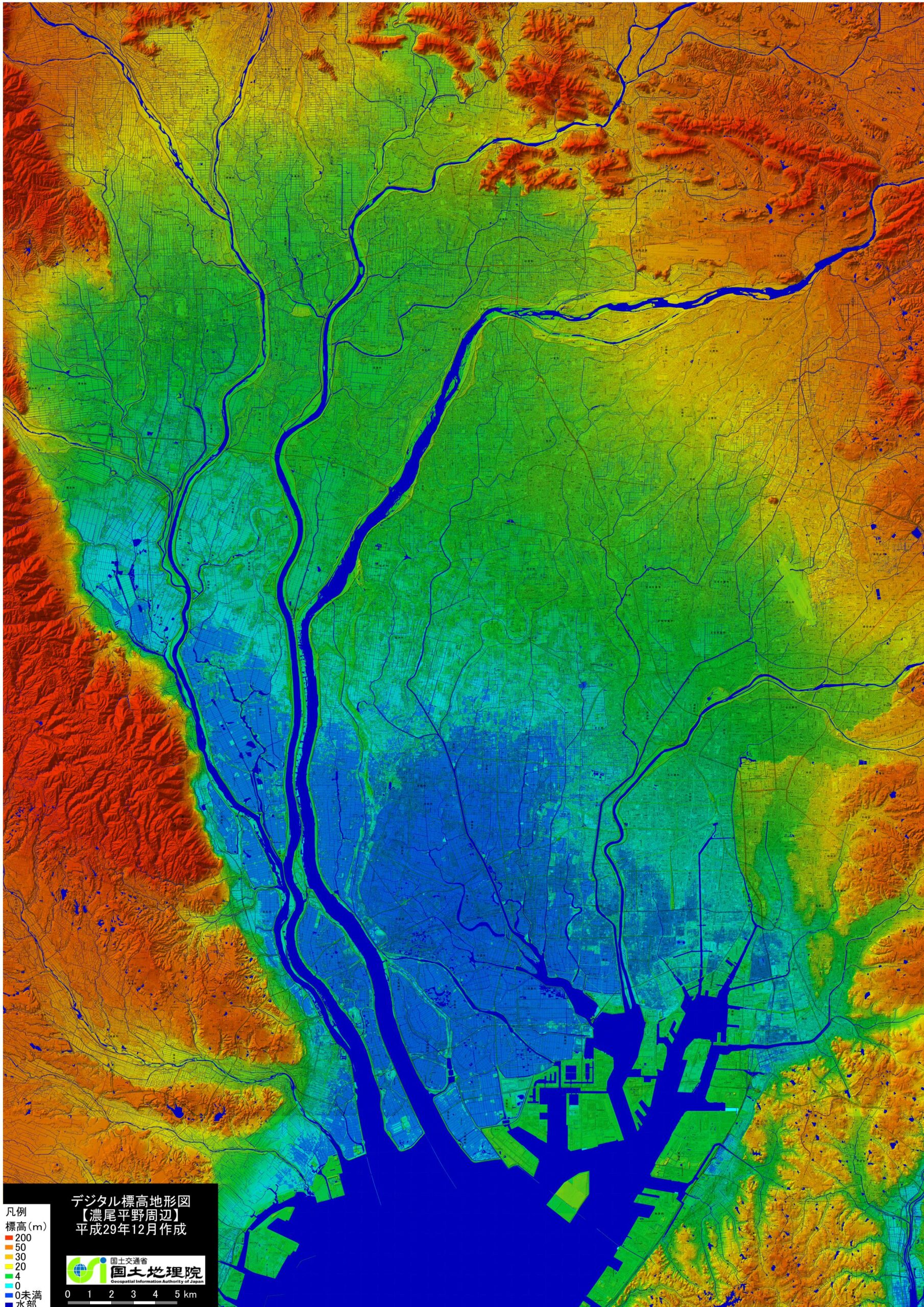
(出典:「国土地理院」,「デジタル標高地形図」(濃尾平野周辺))
(Source: ‘Geospatial Information Authority of Japan’, ‘Digital Elevation Topographic Map’ (Nobi Plain area))
上図は、濃尾平野周辺の地勢を「標高」で示した「国土地理院」の地形図である。名古屋を中心に、その周辺、愛知、岐阜、三重、三県にまたがる地域の標高地形を示している。この地形図内の「凡例」にあるとおり、「濃い青(標高0m未満)、水色(標高0m)そして緑(標高4m)、つまり標高4m未満の地が広大に広がっている地」である。
このことからも、名古屋は「地勢的には水害に弱い街」ということが分る。下図は「名古屋市のホームページ」より引用したものであるが、名古屋駅のある「中村区」、その右隣りの「中区」の中心地「栄」では、昨日の豪雨で道路が川のようになっていたのが報道されていたが、名古屋市の各所で河川の氾濫や道路の冠水が起きていた。
行政でも、過去の豪雨被害を踏まえて、地下50メートルに巨大な「名古屋中央雨水調整池」を建設するなど、大きな労力を費やし都市の浸水対策として大規模な雨水貯留施設を進めているが、それを超える量の雨が昨日は降ったということである。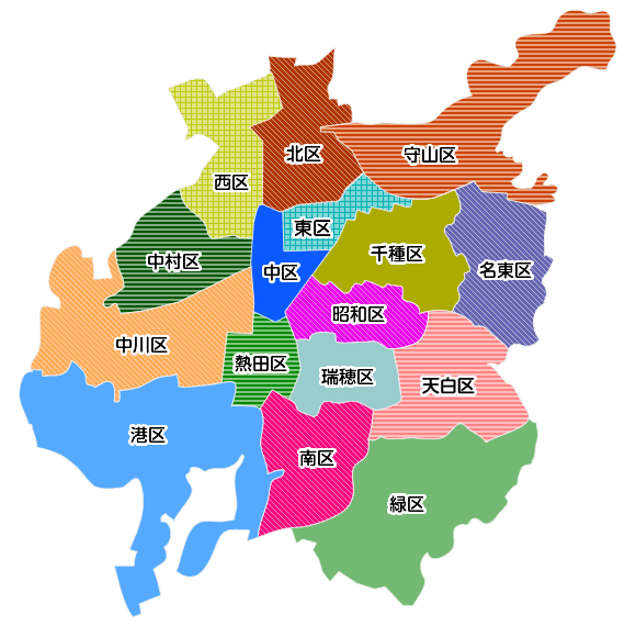
(出典:「名古屋市公式ホームページ『区のプロフィール』)
(Source: ‘Ward Profiles’ on the official Nagoya City website)
3.名古屋の地形の成り立ち
陶磁器の有名産地(郷)のなかで、「日本三大陶磁器の郷」と言われているのは、佐賀県有田町を中心に焼かれる陶磁器「有田焼」、陶磁器生産量日本一の土岐市を中心に制作されている「美濃焼」、そして陶磁器のことを一般的に「瀬戸物」と呼ぶように、その知名度が高い瀬戸の「瀬戸焼」である。
「中世、陶磁器の細工に長けていた中国、朝鮮半島に近い場所に、良質の粘土を得ることができた『有田』が存在した」ということは理解できるが、なぜ、九州を遠く離れた東海地方に、「三つのうち二つの有名な陶磁器の郷が存在した」のか。その背景には、東海地方の地層構造が深く関係している。
「陶土」として使える良質の粘土層は、古代、湖や沼であった地が隆起して丘陵地になっている場所、また古代に川底であった河岸段丘の土地で得られることが多い。その上流域から、風化珪石や長石等の諸鉱物を含んだ岩石が砕かれて流入、沈殿、堆積して粘土層が生成されているからである。
名古屋市のホームページの「生物多様性2050なごや戦略」の第2章「自然が創り人が造った名古屋」によると、前述の「国土地理院の地形図」の「青色」「水色」そして「緑色」の一帯は、「650万~100万年前には伊勢湾北部や北勢・濃尾地域に湖沼や低湿地(東海湖)が広がる」と記されている。つまり、数百万年前には、伊勢湾北部から濃尾平野に現在の琵琶湖の何倍もある巨大な湖、「東海湖」が存在したということである。
「緑色」に近接する「黄色」から「黄土色」の地帯のなかに、現在の瀬戸、多治見、土岐がある。東海湖には、周りの山や丘から花崗岩の白色の細粒が流れ込み湖底に、陶磁器の原料、飲食器、洗面台やトイレといった衛生陶器等の製作には不可欠な最高品質の「白い粘土質」が形成されていった。瀬戸、多治見、土岐の地が「陶磁器の郷」となった背景である。
その後の地殻変動によって東海湖は姿を消したと言われているが、「湖底」に堆積した粘土は焼き物に欠かせない原料となった「東海湖の置き土産」である。
「名古屋は、昔、巨大な湖であった」ということであり、このことが、今回の水害でも明らかなように「名古屋がはらむ地勢リスク」ということは否めない。
4.名古屋が必要とするリスク・マネジメント
現在から7,000年~5,000年前、氷河期の終わりとともに地球の気温は継続的に上昇した。氷が融け海洋に流出していった。北半球の中高緯度の多くが最も温暖な時期を迎えたのは、「ヒプシサーマル(hypsithermal)」(「完新世の気候最温暖期」)と呼ばれる時期である。
先日のネパールの大規模な土石流の原因として「氷河が姿を消している」ということが言われているが、同じようにこの「ヒプシサーマル」の時期、氷河は北米やヨーロッパから姿を消し、グリーンランドと南極大陸に残るのみとなっていた。この氷河の融水の流出は、単に「水が多く供給される」ということだけではなく、氷河があった場所からはその重みが無くなり、一方この「水」によって海底には新たな重みが加わることにいうことになった。
この結果、陸上では隆起運動、海洋では沈降運動が起き始める。この温暖化によって、地球各地では、湿潤化して森林が増加、草原の減少が起き、マンモスなど大型哺乳類を絶滅させることになったと言われている。
このヒプシサーマルの時期は、日本では「縄文時代」の時期と重なり、海水面が大きく上昇、ピーク時である約6,000年前まで上昇し続け、海水面は5メートルほど高くなった。これは、「海が内陸部に進む」ということから「縄文海進」と呼ばれている。
冒頭の「国土地理院」の「デジタル標高地形図」(濃尾平野周辺)から、縄文時代の海岸線の位置を推測すると、「濃青色」の水域、「青色」の標高0m未満地帯、「水色」の0m地帯、そして「緑色」の4m地帯、これら全域が「縄文時代には海であった」ということになる。
つまり、名古屋市は熱田台地、御器所台地等の台地及び東の東部丘陵地帯を除く全地域、北は岐阜市の山沿いまで、北東は各務ヶ原市・犬山市の山沿いまで、北西は大垣市のほぼ全域まで、そして西は養老山地まで、この広大な一帯が海であったことが推測できる。
JR名古屋駅の標高は約2.2mである。栄の市役所の標高は約12.4m。熱田台地に立つ名古屋城の標高でさえ約14mと全般的に低地である。また、その低地を形成している沖積層の特徴は「軟弱な地盤」である。
「低地」と「軟弱な地盤」という自然災害に対する二つの大きなリスクと戦うため、先人達は、熱田台地の南端に熱田神宮、中央部に東別院、北端には名古屋城を建てていたのである。先人の「リスクマネジメント」であったと言えよう。
その後、河川の土砂堆積によって海岸線は徐々に南下、戦国時代には「中川区」までが陸地となり、その後、干拓が進んで今の名古屋市が形成されたが、名古屋市の西側は「海抜の低い土地」であり、「津波」の被害に遭いやすい地形となっている。それを示すように、名古屋市のホームページ(「防災・危機管理」の箇所)には次のような記述がある。
南海トラフ巨大地震が発生した場合に津波浸水が予想される、中村区、瑞穂区、熱田区、中川区、港区、南区及び緑区に海抜を表示し、普段からの防災意識の高揚と発災時の迅速な避難の目安としていただけるよう、海抜表示を実施しています。
このような、津波による外水氾濫の危険姓が高い地域で非常に重要な「地震保険」の補償分野が「地震による事業の継続に問題が起き、事業収益が落ち込むリスク」に対応する補償、「事業中断リスク」(英文では「Business Interruption(ビジネス・インタラプション):BI」である。
自社の掛けている地震保険にこの補償が入っているかどうかによって、災害復旧への金銭的な支えは大きく異なることに注意が必要である。「地震保険はどこでも同じ」ではないからである。
今回のまとめ
東日本大震災から15年が経過したが、この大地震で揺らされた「日本列島」が乗るのは四つのプレート。
北米プレート、太平洋プレート、そしてユーラシアプレートとフィリピン海プレートであり、この二つのプレートの接地面は、今一番危惧されている「南海トラフ巨大地震」を発生させる「南海トラフ」である。
工場で生産した製品は、できるだけ安価な輸送手段で消費地に届けたいと考えるため、工場は、一般的には港湾に近い場所に建設されるが、このことは大地震の際に発生する「液状化」に遭うリスクを高めることにもなっている。しかも、「昔、『東海湖』という湖だった場所」が液状化するリスクは想像に難くない。その地域が濃尾平野全域に拡がっているのである。
地震が発生して工場の建屋や製品、半製品等が受ける直接的な損害のみならず、この液状化による損害は、東日本大震災の際に関東地域で発生した大規模な液状化現象による損害額が大きかったことは記憶に新しい。「キャプティブ」を介した地震保険プログラムの必要性が強く叫ばれる所以である。
なぜか、その理由は、液状化リスクは「生産設備の回復遅れ」や「製品の搬出困難」を引き起こすため、企業業績に大きな影響を与え、企業収益の低下をきたす可能性が高いが、日本で企業向けに販売されている一般的な地震保険は、直接の「物的損害:PD (Property Damage(プロパティ・ダメージ)」のみが補償されている傾向が強く、損害保険会社がこの「事業の中断による収益低下リスク:BI(Business Interruption)(ビジネス・インタラプション)」を積極的に引き受けることはないからである。
一方、欧米で普通に販売されている地震保険は「物的損害:PD(Property Damage) 」に加え、この地震による「事業の中断による収益低下リスク」(「Business Interruption(ビジネス・インタラプション):BI」)が補償されている、「物的損害リスク対応」だけでは片手落ちで「事業の中断による収益低下リスクへの対応」が無ければ「地震保険としての意味が無いから」である。
ここに「この欧米の地震保険を再保険の形で日本で具現化することができる『キャプティブ』を設立する大きなメリットが存在する」のである。
日本では一般的ではない「地震保険の補償:事業の中断による収益低下リスク」をキャプティブからの再保険(保険契約者から見れば再々保険となる)を受けるロンドン・マーケットの再保険会社で確保して日本の元受保険会社に提供する、このことによって、地震による「事業の中断による収益低下リスク」を補償することができる。
キャプティブの設立までには、通常数ヶ月以上掛かるという現実がある。大地震が起きてから、「やっておけば良かった」と後悔しないためにも、一刻も早く取り組むことが肝要ではないかと冒頭のデジタル標高地形図を見て感じた。
今から14年前、2012年8月、国の「有識者会議」が発表した「南海トラフ巨大地震の被害想定」では、液状化リスクだけで、愛知県では約2万3000棟が全壊すると発表されているからである。
執筆・翻訳者:羽谷 信一郎
English Translation
Captive (CA) 88 – During the Jōmon period, Nagoya was covered by the sea.
Although I enrolled at a secondary school in Fukuoka Prefecture, we moved to Gifu that summer due to my father’s job transfer; as someone who spent my secondary school years in Gifu, Nagoya is a city that feels very familiar to me.
Nagoya, like Gifu, is famous for its intense summer heat; however, it is also plagued by snow in winter. At Mount Ibuki—the main peak of the Ibuki Mountains, which run north to south along the border between Shiga and Gifu Prefectures—moist air flowing in from the Sea of Japan towards Lake Biwa collides with cold seasonal winds from Siberia. This unique topography causes vast amounts of snow to fall on the mountain. At ‘Sekigahara’, at the foot of the mountain, the Shinkansen often comes to a halt because of this snow.
The snow depth of 11 metres 82 centimetres, recorded on 14 February 1927, holds the Guinness World Record for the deepest snowfall ever recorded in a mountainous region. Furthermore, a cold and harsh local wind known as the ‘Ibuki Oroshi’ blows down from this mountain toward the Nōbi Plain, making it common to see snow even in the bustling city centre of Nagoya.
However, this year, we witnessed the ‘significant risk’ posed by these geographical features even during the summer.
1. Torrential rain on 8 September 2026
This is because yesterday, 8 September 2026, Nagoya recorded torrential rain of 104.5 mm per hour—the highest on record—resulting in widespread road flooding and water damage.
The Nikkei (web edition), published at 16:22 on 8 September 2026 (updated at 00:50 on 9 September 2026), carried the following article entitled ‘Level 5 Special Flood Warning Temporarily Issued for Aichi and Gifu; Japan Meteorological Agency Calls It “Unprecedented Heavy Rain”’. The text is quoted below.
On the afternoon of the 8th, a linear precipitation zone formed over Aichi and Gifu Prefectures, bringing torrential rain. The Japan Meteorological Agency issued a Level 5 Special Flood Warning for the Shonai River, which flows through western Aichi Prefecture and the Mino region of Gifu Prefecture. Stating that flooding was highly likely to have already occurred, the Agency urged the public to ensure their safety immediately.
The Agency also issued Level 4 danger warnings for heavy rain and landslides in both regions. In Nagoya City, hourly rainfall reached 104.5 millimetres, surpassing the 97 millimetres recorded during the Tokai torrential rains of September 2000—which caused extensive damage—and marking the highest figure on record.
In addition, 93 millimetres were recorded in Tajimi City, Gifu Prefecture, whilst Yokkaichi City in Mie Prefecture and Kanie Town in Aichi Prefecture saw rainfall exceeding 70 millimetres.
According to figures from the Fire and Disaster Management Agency of the Ministry of Internal Affairs and Communications as of 7.00 pm on the 8th, an ‘Emergency Safety Assurance’ alert was issued to over 1.17 million people in approximately 600,000 households across Aichi Prefecture, urging them to take immediate action to protect their lives. Evacuation orders were also issued to approximately 1.3 million people across five prefectures, including Aichi.
This is the second time a Level 5 Special Flood Warning has been issued since June, when one was issued for the Kozagawa River in Wakayama Prefecture. According to the Ministry of Land, Infrastructure, Transport and Tourism, this is the first time such a warning has been issued for a river under direct national jurisdiction.
Takuya Hosomi, Head of the Forecasting Division at the Japan Meteorological Agency, urged the public: “We are experiencing unprecedented heavy rain. If evacuating to a designated location would actually be dangerous, you must ensure your own safety by seeking refuge in higher ground that is less prone to flooding, even if only slightly.”
According to the Ministry of Land, Infrastructure, Transport and Tourism, it has been confirmed that the water level at the observation station on the Yada River, part of the Shonai River system, has reached the ‘flooding threshold’. In the early hours of the 9th, the Japan Meteorological Agency lifted the Level 5 Special Flood Warning for the Shonai River and downgraded it to a Level 2 Flood Advisory.
The Nagoya Municipal Subway also suspended services across its entire network but resumed operations shortly after 10.30 pm on the same day. According to JR Tokai, services on the Tokaido and Sanyo Shinkansen lines were temporarily suspended on the upbound section between Okayama and Tokyo and on the downbound section between Tokyo and Shin-Osaka.
2. Topography of Nagoya
The map above is a topographic map from the Geospatial Information Authority of Japan showing the topography of the area surrounding the Nobi Plain in terms of ‘elevation’. It shows the elevation topography centred on Nagoya and its surrounding areas, as well as parts of the three prefectures of Aichi, Gifu and Mie. As indicated in the ‘legend’ on this topographic map, ‘dark blue (elevation less than 0 m), light blue (elevation 0 m) and green (elevation 4 m)’ indicate that ‘a vast expanse of land lies below an elevation of 4 metres’.
This further illustrates that, topographically speaking, Nagoya is a city vulnerable to flooding. The figure below is taken from the ‘Nagoya City website’. It shows that in ‘Nakamura Ward’, where Nagoya Station is located, and in ‘Sakae’—the centre of ‘Naka Ward’ to its right—roads had reportedly turned into rivers; indeed, yesterday’s torrential rain caused rivers to burst their banks and roads to flood in various parts of Nagoya City.
The local authorities, drawing on lessons from past torrential rain damage, have invested considerable effort in advancing large-scale rainwater retention facilities as urban flood prevention measures—such as the construction of the massive ‘Nagoya Central Stormwater Retention Basin’ 50 metres underground; however, it appears that yesterday’s rainfall exceeded the capacity of these facilities.
3. The Formation of Nagoya’s Topography
Among the famous centres of ceramics production, the ‘Three Great Ceramic Centres of Japan’ are: ‘Arita-yaki’, produced mainly in Arita Town, Saga Prefecture; ‘Mino-yaki’, produced mainly in Toki City, which boasts Japan’s highest ceramic production volume; and ‘Seto-yaki’ from Seto, which is so well-known that the term ‘Seto-mono’ is commonly used to refer to ceramics in general.
Whilst it is understandable that ‘Arita’—a place where high-quality clay could be obtained—existed in the Middle Ages in a location close to China and the Korean Peninsula, regions renowned for their ceramic craftsmanship, why did ‘two of the three famous ceramic villages’ come to be situated in the Tokai region, so far removed from Kyushu? The geological structure of the Tokai region is deeply involved in this.
High-quality clay layers suitable for use as ‘pottery clay’ are often found in areas where ancient lakes and marshes have been uplifted to form hilly terrain, as well as on river terraces that were once riverbeds in ancient times. This is because rocks containing various minerals, such as weathered silica and feldspar, are broken up in the upper reaches of these watercourses, carried downstream, and then settle and accumulate to form clay layers.
According to Chapter 2, ‘Nagoya: Created by Nature, Shaped by People’, of the ‘Biodiversity 2050 Nagoya Strategy’ on the City of Nagoya’s website, the are described as ‘blue’, ‘light blue’ and ‘green’ areas, with the note that ‘between 6.5 million and 1 million years ago, lakes and low-lying wetlands (Lake Tokai) extended across the northern part of Ise Bay and the Hokusei and Nobi regions’. In other words, several million years ago, a vast lake known as ‘Lake Tokai’—many times larger than the present-day Lake Biwa—existed from the northern part of Ise Bay to the Nobi Plain.
The present-day towns of Seto, Tajimi and Toki are situated within the ‘yellow’ to ‘ochre’ zone adjacent to the ‘green’ area. Fine-grained white granite from the surrounding mountains and hills flowed into Lake Tokai, gradually forming on the lake bed the highest-quality ‘white clay’—an essential raw material for the production of ceramics, tableware, and sanitary ware such as washbasins and toilets. This is the background to how the regions of Seto, Tajimi and Toki became ‘the home of ceramics’.
Although it is said that Lake Tokai subsequently disappeared due to tectonic shifts, the clay deposited on the ‘lake bed’ remains a ‘legacy of Lake Tokai’—a raw material indispensable for pottery.
This means that ‘Nagoya was once a vast lake’, and, as made clear by the recent flooding, it is undeniable that this represents a ‘geographical risk inherent in Nagoya’.
4. The Risk Management Required in Nagoya
Between 7,000 and 5,000 years ago, as the Ice Age drew to a close, global temperatures rose steadily. Ice melted and flowed into the oceans. Much of the mid-to-high latitudes of the Northern Hemisphere experienced its warmest period during a phase known as the ‘Hypsithermal’ (the ‘Holiocene climatic optimum’).
It has been suggested that the ‘disappearance of glaciers’ was the cause of the recent large-scale mudslides in Nepal; similarly, during this ‘Hypsithermal’ period, glaciers disappeared from North America and Europe, remaining only in Greenland and Antarctica. The outflow of meltwater from these glaciers did not merely result in an ‘increased water supply’; it also meant that the weight of the glaciers was no longer present where they had once stood, whilst this ‘water’ added new weight to the seabed.
As a result, uplift began to occur on land, whilst subsidence began in the oceans. It is said that this warming led to increased humidity across the globe, resulting in the expansion of forests and the decline of grasslands, which ultimately drove large mammals such as the mammoth to extinction.
This Hypsithermal period coincided with the ‘Jōmon period’ in Japan; sea levels rose significantly and continued to rise until their peak approximately 6,000 years ago, reaching a height of around 5 metres. As this involved the sea advancing inland, it is known as the ‘Jōmon Transgression’.
If we infer the position of the Jōmon-period coastline from the ‘Digital Elevation Topographic Map’ (covering the Nōbi Plain area) produced by the ‘Geospatial Information Authority of Japan’ mentioned at the beginning, the entire area—comprising the ‘dark blue’ water areas, the ‘blue’ areas below 0 metres in elevation, the ‘light blue’ 0-metre zone, and the ‘green’ 4-metre zone—would have been ‘underwater during the Jōmon period’.
In other words, it can be inferred that the entire area of Nagoya City—excluding the Atsuta Plateau, the Gokiso Plateau and other plateaus, as well as the eastern hilly region to the east—extending north to the mountainous areas of Gifu City, north-east to the mountainous areas of Kakamigahara City and Inuyama City, north-west to almost the entire area of Ogaki City, and west to the Yoro Mountains, was once covered by the sea.
The elevation of JR Nagoya Station is approximately 2.2 metres. The elevation of the City Hall in Sakae is approximately 12.4 metres. Even Nagoya Castle, situated on the Atsuta Plateau, stands at an elevation of only about 14 metres; the area is generally low-lying. Furthermore, the alluvial deposits that form this low-lying terrain are characterised by ‘soft ground’.
To combat these two major risks posed by natural disasters—‘low-lying terrain’ and ‘soft ground’—our forebears built Atsuta Shrine at the southern tip of the Atsuta Plateau, Higashi-Betsuin in the centre, and Nagoya Castle at the northern tip. This can be described as a form of ‘risk management’ practised by our forebears.
Subsequently, the coastline gradually shifted southwards due to sediment deposition from rivers; by the Sengoku period, the area as far as Nakagawa Ward had become dry land. Following this, land reclamation progressed, leading to the formation of present-day Nagoya City; however, the western part of Nagoya City consists of ‘land at low elevation’ and is geographically prone to damage from ‘tsunamis’. As evidence of this, the Nagoya City website (under the ‘Disaster Prevention and Crisis Management’ section) contains the following statement:
“We have implemented elevation markings in Nakamura Ward, Mizuho Ward, Atsuta Ward, Nakagawa Ward, Minato Ward, Minami Ward and Midori Ward—areas where tsunami inundation is anticipated in the event of a massive Nankai Trough earthquake—to raise public awareness of disaster prevention on a day-to-day basis and to serve as a guide for rapid evacuation in the event of a disaster.”
In such areas, where the risk of external flooding caused by tsunamis is high, a crucial aspect of ‘earthquake insurance’ is the cover for ‘Business Interruption’ (BI), which addresses the risk of business continuity issues arising from an earthquake leading to a decline in business revenue.
It is important to note that the financial support available for disaster recovery can vary significantly depending on whether this cover is included in your company’s earthquake insurance policy.
This is because ‘earthquake insurance is not the same everywhere’.
Summary of this issue
Fifteen years have passed since the Great East Japan Earthquake, but the ‘Japanese archipelago’—which was shaken by that massive earthquake—rests upon four tectonic plates: the North American Plate, the Pacific Plate, the Eurasian Plate and the Philippine Sea Plate.
The boundary between these last two plates is the ‘Nankai Trough’, which is the source of the ‘Nankai Trough mega-earthquake’—the event currently causing the greatest concern.
As manufacturers wish to deliver products from their factories to consumer markets using the cheapest possible means of transport, factories are generally built close to ports; however, this also increases the risk of ‘liquefaction’ occurring during a major earthquake. Moreover, it is not difficult to imagine that ‘the area that was once a lake known as “Lake Tokai”’ is at risk of liquefaction. This region extends across the entire Nobi Plain.
It is still fresh in our minds that the damage caused by this liquefaction—in addition to the direct damage to factory buildings, finished products and semi-finished goods resulting from an earthquake—was significant, as evidenced by the large-scale liquefaction phenomena that occurred in the Kanto region during the Great East Japan Earthquake. This is precisely why there are strong calls for an earthquake insurance programme via ‘captive’ arrangements.
The reason for this is that, whilst liquefaction risks are highly likely to have a significant impact on corporate performance—causing ‘delays in the restoration of production facilities’ and ‘difficulties in transporting products’—and consequently lead to a decline in corporate profits, standard earthquake insurance policies sold to businesses in Japan tend to cover only direct ‘property damage’ (PD). This is because non-life insurance companies generally do not actively underwrite the ‘risk of reduced revenue due to business interruption: BI (Business Interruption)’—which results from business interruption—as a matter of policy.
By contrast, earthquake insurance commonly sold in Europe and the US covers not only ‘Property Damage (PD)’ but also the ‘risk of reduced revenue due to business interruption’ caused by earthquakes (‘Business Interruption: BI’). This is because addressing ‘property damage risk’ alone is insufficient; without ‘cover for the risk of reduced revenue due to business interruption’, ‘earthquake insurance would be meaningless’.
This is precisely where the major advantage lies in establishing a ‘captive’ that can replicate this Western-style earthquake insurance in Japan through reinsurance.
By securing cover for the ‘risk of revenue loss due to business interruption’—a component of earthquake insurance that is not common in Japan—through reinsurance from a captive (which, from the policyholder’s perspective, constitutes re-reinsurance) with a London Market reinsurer, and then providing this cover to Japanese primary insurers, it becomes possible to cover the ‘risk of revenue loss due to business interruption’ caused by earthquakes.
The reality is that it usually takes several months or more to establish a captive. Looking at the digital elevation model at the beginning of this article, I felt that it is essential to take action as soon as possible to avoid regretting, after a major earthquake has struck, that ‘we should have done this’.
This is because, 14 years ago, in August 2012, the ‘Estimated Damage from a Mega-Earthquake in the Nankai Trough’ published by the government’s ‘Expert Panel’ stated that, due to the risk of liquefaction alone, approximately 23,000 buildings in Aichi Prefecture would be completely destroyed.
Author/translator: Shinichiro Hatani