
 Contact

キャプティブ 2026.07.29
CA87 「南海トラフ」の動きが熊本地震の原因ではないか?
Copyright © Shinichiro Hatani 2026 All rights reserved
For those who prefer to read this column in English, the Japanese text is followed by a British English translation, so please scroll down to the bottom of the Japanese text.
昨日、2026年7月28日午後4時27分、熊本県で最大震度7を観測したマグニチュード(M)7.1の地震が震源の深さ10Kmで発生した。
今から10年前、2016年4月にも、今回と同様、最大震度7を観測する地震がこの地域で2回起き、熊本城が大きく損傷を受けた。天守閣は2021年に復旧を完了したが、2052年度を予定していた城全体の完全復旧は、今回の地震で熊本城の石垣が大きく崩落するなどの被害が発生したため、完全復旧までの時間が更に延びることが予想される。
昨日から本日まで多くのTV番組では、多くの地震学の専門家が出演して、今回の地震の解析がおこなわれていた。熊本県内から一部鹿児島県北部に位置する、2つの九州最長の活断層帯、両者合わせると全長は約101kmの「布田川・日奈久断層帯」による、断層が押し合って左右にずれて発生する「横ずれ断層型の直下型地震」と指摘されていた。
2016年の熊本地震では、熊本県の益城町から八代海に向けて延びる「日奈久断層帯」の北側区間と、付近の「布田川断層帯」の一部で破壊が起きたとされ、「今回はそれより南側で発生した」と指摘されていた。
本コラムで、これまで何度か引用したが、政府の地震調査研究推進本部(地震本部)の「主要活断層帯の長期評価」、その「2026年版」では、日奈久断層帯は「今後30年以内のM7級の地震の発生確率は「ほぼ0〜6%」とされ、活断層としては比較的高い発生確率であるため、発生リスクを4段階で評価したランクでは最も高い「Sランク」とされていた。
1.震度7
地震の大きさを表す値に、地震そのものの大きさ(エネルギー)を示す「マグニチュード」と特定の場所での揺れの強さを表す「震度」がある。マグニチュード(M)は「電球のワット数(明るさ)」、そして震度は「電球から離れた場所での明るさ」のように、「電球」に例えて説明されることが多い。
世界各国でそれぞれの国がこの「震度階級(震度)」という指標を有しているが、日本では、気象庁が定める「気象庁震度階級」が使われている。
これは1884年(明治13年)からその整備が始まり、1898年(明治31年)制定され、「0から6までの7段階」となったが、1948年(昭和23年)の福井地震の被害が大きく、新たに「7」が設けられ1949年に「ほぼ揺れを感じない震度0から震度1、2、3、4、5弱、5強、6弱、6強、そして最大の7までの10段階」が制定された。
1949年から本年2026年までの77年間で、「震度7」は、阪神高速道路の橋脚が根元部分から横倒しになるなど大きな被害のあった1995年1月の阪神大震災で初めて記録された。その後今回7月28日の熊本地震地震まで8回記録されたが、そのうち3回が熊本県内で観測された。
2.フォッサマグナ
グローバル・リンクが設立をサポートするキャプティブは、日本の元受保険会社から再保険を引受ける「再保険会社」として機能することになるが、更に「再々保険」の形でその大半のリスクを最終的に引受けるのは、ロンドンの「ロイズ」(Lloyd’s of London) のシンジケートや世界最大級の再保険会社である。そのうちの一社、世界最大の再保険会社はドイツに本社を有する。
彼らとの打ち合わせや協議で同本社をたびたび訪れた。時期が秋頃であれば、その街で開かれる「世界最大級のお祭り」にも折良く参加できる。9月中旬から10月初旬に掛けて開かれる世界最大のビール祭り、「オクトーバー・フェスト」である。
参加する多くのドイツ人は男性も女性も「ドイツ風というより、地勢的に近いスイス風の民族衣装」で着飾っていた。全世界から600万人を超える人々が、「歌い、踊り、語らい、ビールを飲む」ために参加する、その「祭り」が開かれる場所はドイツ南部の中核都市、ミュンヘンである。
明治時代初期、そのミュンヘンから、いわゆる「お雇い外国人」として招かれ東京帝国大学(現・東京大学)の地質学採鉱学科の初代教授となった、ハインリッヒ・エドムント・ナウマン。理科の教科書に、「古代、日本に生息していたゾウの化石を発見した人物」として、また「そのゾウは彼の名前から『ナウマンゾウ』と名付けられた」と載っている人物である。
これまで本コラムで度々紹介してきた「国立研究開発法人産業技術総合研究所(産総研)」の歩みは、1882年(明治15年)に国立の地質調査機関である地質調査所が設立されたことに始まるが、この地質調査所の設立には、ドイツから来日した地質学者ナウマンが深くかかわっていた。
「地質学者ナウマン伝 フォッサマグナに挑んだお雇い外国人 (朝日選書) 」(矢島 道子 (著) 朝日新聞出版(刊))によると、ミュンヘン大学を卒業して1875年に来日したナウマンは、その後設立された東京帝国大学地質学科の初代教授として、全国の地質調査を進言、立案した。
その後、1885年に帰国するまでの10年間、北海道を除く日本全国を広く調査、日本の地質構造について「日本高度階分布地図」をまとめるなかで、巨大な大地溝帯の存在を思いつき、1885年開かれたベルリンの国際学会(万国地質学会議)で発表、翌年この大地溝帯をラテン語で「大きな溝」を意味する「フォッサマグナ」と名付けた。
日本列島は、地質学的には「ユーラシアプレート」と「北米プレート」の境、大地溝帯である「フォッサマグナ」によって、「プレート」が別れ、日本列島の西半分は「ユーラシアプレート」、北海道を含めた東半分は「北米プレート」と、「乗っている土台」が異なる。
このフォッサマグナは、下図の肌色で描かれた、日本列島の中央、中部地方から関東地方にかけての地域を縦断する大地溝帯である。
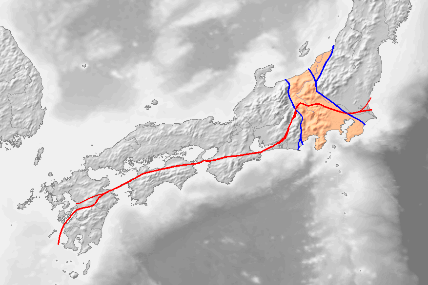
西縁は「糸魚川静岡構造線」(糸静線)となっているが、東縁については「新発田小出構造線」、「柏崎千葉構造線」等と諸説あり現在も結論は出ていない。
3.世界最大の断層帯、「中央構造線」
上図には、関東から九州に伸びる「赤いライン」が記されている。断層の大規模な動きによって、断層の両側に違う岩石が並び、異なる地質の境界線になっている大断層帯を「構造線」と呼ぶ。
この赤いラインは、九州の八代から、徳島、三重、そして諏訪を経て、茨城から太平洋へ抜ける、1000Km以上もある長大な大断層帯であり、「中央構造線」と呼ばれるものであるが、この命名者もナウマンである。
中央構造線は、茨城から関東を通り、諏訪を経て、三重、和歌山、さらに四国を縦断して大分に入り、九州へ、今回の大地震の発生地である八代、熊本を経て太平洋へ抜ける長大な大断層帯である。
九州、大分県から熊本県に至る一帯を走る中央構造線上には、別府温泉をはじめ湯布院と有名な温泉地が連なっていて、この温泉地熱現象には新しい火山活動や地震が活発な地域である。
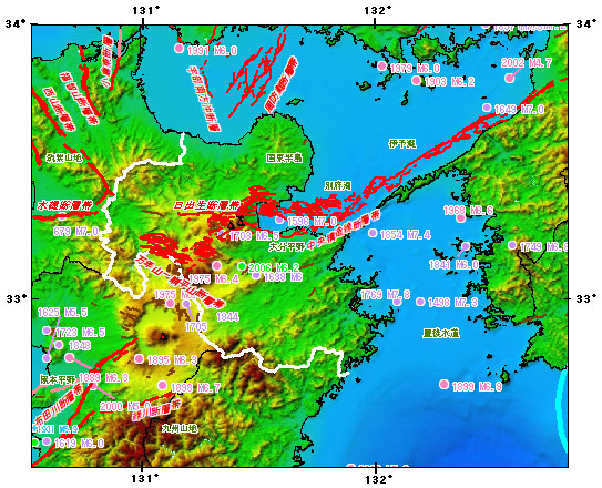
(出典:政府「地震調査研究推進本部」公式WEBサイト」)
「中央構造線」は、上図中央にある「別府湾」の表記の下に、「中央構造線断層帯」と赤字で記されている。
4.南海トラフ地震の影響は
今回の熊本地震を専門家は「断層型地震」と評している、無論直接的には「断層が動いたことによる断層型地震」であるが、日本列島の真ん中を1000Kmに渡って東西に走る「中央構造線」の西の端で起きたことを筆者は非常に懸念している。
日本列島の真ん中にある大地溝帯「フォッサマグナ」を境にして、西半分は「ユーラシアプレート」、東半分は「北米プレート」とその「土台」が別れている。
大陸側の「ユーラシアプレート」の下に、南側から海洋プレートである「フィリピン海プレート」が接して年間数㎝の割合で沈み込んでいる場所を「南海トラフ」というが、その大変動が「南海トラフ大地震」として、100~150年間隔で繰り返し発生している。
南海トラフ地震である「昭和東南海地震(1944年)」、その後の「昭和南海地震(1946年))」が発生してから80年以上が経過した現在では、次の南海トラフ地震発生の切迫性が高まってきている。
2016年4月発生した「熊本地震」の後、多くの被災者が「熊本には大きな地震は来ないと思っていた」と語っていたことを記憶している。それが、2016年に続き、10年後の本年発生している、しかも、それが「中央構造線」上の断層帯付近で。
筆者は、フィリピン海プレートがユーラシアプレートの下に沈み込んでいる接地面、「南海トラフ」での沈み込みがユーラシアプレートを押し、その上にある断層帯に大きな影響を与えているのではないかと危惧している。
「ミクロの眼」で見ると、今回の熊本地震は「断層型地震」であろうが、「マクロの眼」で見ると、それらの断層が乗っている「プレート」が動かされて、その結果「断層が動いた」と考える方が、「大きな地震は来ない地域と思われていた地域で大地震が続いて起きていることを説明するには適切であり、根源をよく見るべきではないか」と考えている。
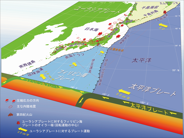
この図は、「国立研究開発法人 産業技術総合研究所(「産総研」)」の公式WEBサイトから、「日本列島周辺のプレート運動と頻発する内陸地震 本州の広い範囲は東西方向に押されている(図中の赤矢印)」と題する図を引用したものである。
今回のまとめ
地球を覆うプレートには、「大陸側のプレート」と「海側のプレート」がある。日本を囲むプレートでは、大陸側が「ユーラシアプレート」と「北米プレート」であり、海側が「太平洋プレート」と「フィリピン海プレート」である。
この4つのプレートの上に「乗っている」のが日本である。移動する「プレート」が4つもある世界でも希な場所が日本列島である、だから地震が頻発する。
海洋プレートは、大陸プレートよりも強固で密度が高いため、2つのプレートが衝突すると海洋プレートは大陸プレートの下に沈んでいく。
太平洋プレートが北米プレートの下に沈み込んでいく際に発生した地震が「東日本大震災」であり、フィリピン海プレートがユーラシアプレートの下に沈み込んでいる接地面を「南海トラフ」と言い、その沈み込みの際に発生する現象が、発生が強く懸念されている「南海トラフ巨大地震」である。
損害保険の世界では、「事故などで対象物が物理的影響を被ること」を「損害」といい、「損害を被った結果、その対象と一定の関係がある人に与える経済的影響のこと」を「損失」というが、「地震リスク」という「損失を被る可能性」である不確定な要素を保険料というコストとして確定させる仕組みである「地震保険」を活用することによって「企業経営の不確実性」を減じていくことは、重要な経営戦略である。
しかし、「地震保険」を利用したとしても、単なる地震による建物等の損壊というリスクだけではなく、「平安時代に高知で起きたような大規模な地殻変動が起き陸地が海没する」事態にも対応できる地震保険でなければその意味を成さない。
日本で一般的に手に入る地震保険は、単なる物的損害のみを補償する地震保険である。
そのために必要なものが欧米では一般的なリスクマネジメント策と言われて、ほとんどの大企業、団体では「当り前に設立されている仕組み」がキャプティブである。
執筆・翻訳者:羽谷 信一郎
English Translation
Captive (CA) 87 – Could movement in the ‘Nankai Trough’ have caused the Kumamoto earthquake?
Yesterday, at 4.27 pm on 28 July 2026, an earthquake measuring 7.1 on the Richter scale (M) struck Kumamoto Prefecture, with a maximum seismic intensity of 7 recorded at a depth of 10 km.
Ten years ago, in April 2016, two earthquakes similar to this one, both recording a maximum seismic intensity of 7, struck the region, causing significant damage to Kumamoto Castle. Although restoration of the main keep was completed in 2021, the full restoration of the entire castle was expected to take a considerable amount of time, with completion scheduled for the 2052 financial year. However, due to further significant damage, including the collapse of Kumamoto Castle’s stone walls, the time required for full restoration is now expected to be extended.
From yesterday through to today, seismology experts have appeared on numerous television programmes to analyse this earthquake. They have pointed out that it was a ‘strike-slip type shallow-focus earthquake’ caused by the ‘Fudagawa–Hinagu Fault Zone’—Kyushu’s longest active fault zone, spanning approximately 101 km in total length and extending from within Kumamoto Prefecture to a part of northern Kagoshima Prefecture—where the faults pushed against each other and shifted laterally.
In the 2016 Kumamoto Earthquake, it is believed that rupture occurred in the northern section of the ‘Hinagu Fault Zone’—which extends from Mashiki Town in Kumamoto Prefecture towards the Yatsushiro Sea—and in a part of the nearby ‘Futagawa Fault Zone’; experts appearing in the media have pointed out that ‘this time, the earthquake occurred further south than that’.
As I have cited several times in this column, the Government’s Earthquake Headquarters’ ‘Long-term Assessment of Major Active Fault Zones’, in its ‘2026 Edition’, stated that the probability of a magnitude 7-class earthquake occurring on the Hinagu Fault Zone within the next 30 years is ‘approximately 0–6 per cent’. As this is a relatively high probability for an active fault, it was assigned the highest rating, ‘S-rank’, on a four-tier scale for assessing earthquake risk.
1. Seismic Intensity 7
There are two measures used to indicate the size of an earthquake: ‘magnitude’, which indicates the size (energy) of the earthquake itself, and ‘seismic intensity’, which indicates the strength of the shaking at a specific location. Magnitude (M) is often explained using the analogy of a ‘light bulb’—its ‘wattage’ (brightness)—whilst seismic intensity is likened to the ‘brightness at a distance from the light bulb’.
Whilst countries around the world have their own indicators for ‘seismic intensity scales’, in Japan the ‘Japan Meteorological Agency Seismic Intensity Scale’ established by the Japan Meteorological Agency is used.
Work on developing this scale began in 1884 (Meiji 13) and it was formally established in 1898 (Meiji 31) as a ‘seven-point scale ranging from 0 to 6’. However, following the extensive damage caused by the Fukui Earthquake in 1948 (Shōwa 23), a new ‘7’ was introduced, and in 1949, a ‘10-point scale ranging from Seismic Intensity 0 (where shaking is barely felt) to Seismic Intensity 1, 2, 3, 4, 5-weak, 5-strong, 6-weak, 6-strong, and the maximum level 7’ was established in 1949.
Over the 77 years from 1949 to the present year, 2026, ‘Seismic Intensity 7’ was first recorded during the Great Hanshin Earthquake in January 1995. The urban area of Kobe was struck by violent shaking, causing, for example, the bridge piers of the Hanshin Expressway to topple sideways from their bases; 6,434 people lost their lives, including disaster-related deaths. Since then, up to the Kumamoto Earthquake on 28 July this year, it has been recorded eight times, three of which were observed within Kumamoto Prefecture.
2. Fossa Magna
The captive, whose establishment Global Link is supporting, will function as a ‘reinsurance company’ that underwrites reinsurance from Japanese primary insurers; however, the majority of the risk is ultimately underwritten in the form of ‘re-reinsurance’ by syndicates at ‘Lloyd’s of London’ and some of the world’s largest reinsurance companies. One of these, the world’s largest reinsurance company, has its headquarters in Germany.
I frequently visited their headquarters for meetings and discussions. If the timing was around autumn, I was fortunate enough to take part in one of the ‘world’s largest festivals’ held in that city: the ‘Oktoberfest’, the world’s largest beer festival, which takes place from mid-September to early October.
Many of the Germans attending, both men and women, were dressed in ‘traditional costumes that, rather than being typically German, were more in the Swiss style, given the geographical proximity’. This ‘festival’, which attracts over six million people from all over the world to ‘sing, dance, chat and drink beer’, takes place in Munich, a major city in southern Germany.
In the early Meiji period, Heinrich Edmund Naumann was invited from Munich as a so-called ‘foreign expert’ and became the first professor of the Department of Geology and Mining at Tokyo Imperial University (now the University of Tokyo). He is the figure described in science textbooks as ‘the person who discovered the fossils of an elephant that lived in Japan in ancient times’, and as the one after whom ‘that elephant was named the “Naumann elephant”’.
The history of the ‘National Institute of Advanced Industrial Science and Technology (AIST)’, which has been featured frequently in this column, began with the establishment in 1882 (Meiji 15) of the Geological Survey of Japan, a national geological survey organisation; the geologist Naumann, who had come to Japan from Germany, was deeply involved in the establishment of this organisation.
According to *The Biography of Geologist Naumann: The Foreign Expert Who Took on the Fossa Magna* (Asahi Sensho) (by Michiko Yajima, published by Asahi Shimbun Publications), Naumann, who graduated from the University of Munich and arrived in Japan in 1875, served as the first professor of the Department of Geology at the subsequently established Tokyo Imperial University, where he advocated for and planned nationwide geological surveys.
Over the following ten years, until his return to Germany in 1885, he conducted extensive surveys across the whole of Japan, with the exception of Hokkaido. Whilst compiling the ‘Map of Elevation Grades in Japan’ to document the country’s geological structure, he conceived the idea of a massive rift valley. He presented his findings at the International Geological Congress held in Berlin in 1885, and the following year named this rift valley ‘Fossa Magna’, a Latin term meaning ‘great trench’.
Geologically speaking, the Japanese archipelago lies at the boundary between the ‘Eurasian Plate’ and the ‘North American Plate’. The ‘Fossa Magna’, a major rift valley, separates these plates; the western half of the Japanese archipelago lies on the ‘Eurasian Plate’, whilst the eastern half, including Hokkaido, lies on the ‘North American Plate’, meaning they rest on different tectonic foundations.
The Fossa Magna is a major rift valley system depicted in flesh colour in the diagram below, running vertically through the centre of the Japanese archipelago from the Chūbu region to the Kanto region.
Whilst its western boundary is defined as the ‘Itoigawa–Shizuoka Tectonic Line’ (Ito-Shizu Line), there are various theories regarding its eastern boundary—including the ‘Shibata–Koide Tectonic Line’ and the ‘Kashiwazaki–Chiba Tectonic Line’—and no definitive conclusion has yet been reached.
3. The World’s Largest Fault Zone: the ‘Central Tectonic Line’
The map above shows a ‘red line’ extending from the Kanto region to Kyushu. A ‘tectonic line’ refers to a major fault zone where, as a result of large-scale fault movement, different types of rock are aligned on either side of the fault, forming a boundary between distinct geological formations.
This red line represents the ‘Central Tectonic Line’, an extensive fault zone stretching over 1,000 km from Yatsushiro in Kyushu, through Tokushima, Mie and Suwa, before emerging into the Pacific Ocean via Ibaraki. This name was also coined by Naumann.
The Central Tectonic Line is an extensive fault zone that runs from Ibaraki through the Kanto region, via Suwa, through Mie and Wakayama, then across Shikoku into Oita, and finally through Yatsushiro and Kumamoto in Kyushu to the Pacific Ocean. Along the Central Tectonic Line, which runs through the area from Oita Prefecture to Kumamoto Prefecture in Kyushu, there is a succession of famous hot spring resorts, including Beppu Onsen and Yufuin; this region, characterised by geothermal activity, is also known for its recent volcanic activity and frequent earthquakes.
(Source: Official website of the Government’s ‘Headquarters for the Promotion of Earthquake Research’)
The ‘Central Tectonic Line’ is labelled in red as the ‘Central Tectonic Line Fault Zone’ beneath the label ‘Beppu Bay’ in the centre of the map above.
4. The impact of the Nankai Trough earthquake
Experts have characterised the recent Kumamoto earthquake as a ‘fault-type earthquake’. Whilst it is, of course, directly a ‘fault-type earthquake caused by fault movement’, the author is deeply concerned that it occurred at the western end of the ‘Central Structural Line’, which runs east-west for 1,000 km through the centre of the Japanese archipelago.
The ‘Fossa Magna’, a major rift valley running through the centre of the Japanese archipelago, forms the boundary between the ‘Eurasian Plate’ to the west and the ‘North American Plate’ to the east, with their respective ‘foundations’ lying on either side.
The ‘Nankai Trough’ is the area where the ‘Philippine Sea Plate’—an oceanic plate—borders the continental ‘Eurasian Plate’ from the south and subducts at a rate of several centimetres per year; major seismic events in this region, known as the ‘Nankai Trough Earthquakes’, recur at intervals of 100 to 150 years.
More than 80 years have now passed since the last Nankai Trough earthquakes—the ‘Shōwa Tōnankai Earthquake (1944)’ and the subsequent ‘Shōwa Nankai Earthquake (1946)’—and the likelihood of the next Nankai Trough earthquake occurring is now increasing.
I recall that, following the ‘Kumamoto Earthquake’ in April 2016, many of those affected said, ‘We never thought a major earthquake would strike Kumamoto’. Yet, following the event in 2016, another has occurred this year—ten years later—and, moreover, near the fault zone along the ‘Central Tectonic Line’.
I believe that the subduction at the ‘Nankai Trough’—the boundary where the Philippine Sea Plate is subducting beneath the Eurasian Plate—is exerting significant pressure on the Eurasian Plate, thereby having a major impact on the fault zone above it.
Viewed through a ‘microscopic lens’, the recent Kumamoto earthquake may well be a ‘fault-type earthquake’; however, it seems more appropriate to consider that the ‘plate’ on which the fault rests was displaced, resulting in the ‘fault moving’—as this better explains why a major earthquake occurred in a region previously thought to be free from such events.
Summary of this issue
The plates covering the Earth consist of ‘continental plates’ and ‘oceanic plates’. Among the plates surrounding Japan, the continental plates are the ‘Eurasian Plate’ and the ‘North American Plate’, whilst the oceanic plates are the ‘Pacific Plate’ and the ‘Philippine Sea Plate’.
Japan ‘rests’ upon these four plates. The Japanese archipelago is a rare place in the world where as many as four moving ‘plates’ converge; this is why earthquakes occur so frequently.
As oceanic plates are stronger and denser than continental plates, when the two plates collide, the oceanic plate subducts beneath the continental plate.
The earthquake caused by the subduction of the Pacific Plate beneath the North American Plate was the ‘Great East Japan Earthquake’. The boundary where the Philippine Sea Plate is subducting beneath the Eurasian Plate is known as the ‘Nankai Trough’, and the phenomenon resulting from this subduction is the ‘Nankai Trough Mega-Earthquake’, the occurrence of which is a major cause for concern.
In the world of non-life insurance, ‘damage’ refers to ‘physical impact suffered by an object as a result of an accident or similar event’, whilst ‘loss’ refers to ‘the economic impact on persons with a certain relationship to that object as a result of the damage suffered’. Utilising ‘earthquake insurance’—a mechanism that converts the uncertain element of ‘earthquake risk’, i.e. the ‘possibility of suffering a loss’, into a fixed cost in the form of insurance premiums—is an important management strategy for reducing ‘uncertainty in corporate management’.
However, even when utilising ‘earthquake insurance’, it is meaningless unless the policy covers not only the risk of damage to buildings and other structures caused by earthquakes alone, but also the risk of ‘large-scale crustal movements, such as those that occurred in Kochi during the Heian period, causing land to sink beneath the sea’.
Generally available earthquake insurance policies cover only physical damage. To address this, a mechanism known in the West as a standard risk management measure—and one that is ‘routinely established’ by most large corporations and organisations—is the captive.
Author/translator: Shinichiro Hatani