
キャプティブ 2021.09.10
CA31 南海トラフ大地震(高知「黒田郡」沈没)Great Nankai Trough Earthquake (Kochi “Kuroda-Gori” sinking)
目次
- 1.平安時代の三大地震
- 2.平安時代、鎌倉時代の大地震
- 3.康和南海地震による土佐(高知)の被害
- 4.海底に没した、高知“黒田郡(くろだごおり)”
- 5.防災科学技術研究所(防災科研:NIED)
- 6.政府地震調査研究推進本部の所見
- 今回のまとめ
- 1. The Three Great Earthquakes of the Heian Period
- 2. Major earthquakes in the Heian and Kamakura periods
- 3. Damage in Tosa (Kochi) caused by the Ko-wa Nankai Earthquake
- 4. Kochi’s “Kuroda Goori (Village)” submerged in the sea bed
- 5. National Research Institute for Earth Science and Disaster Prevention (NIED)
- 6. Opinion of the Headquarters for Earthquake Research Promotion, Government of Japan
- Summary of this issue
For those who prefer to read this column in English, the Japanese text is followed by a British English translation, so please scroll down to the bottom of the Japanese text.
2021年9月3日共同通信が、以下の記事を配信した。
千年ほど昔の平安―鎌倉時代に、房総半島沖でマグニチュード(M)8.5程度とみられる未知の巨大地震が起き、千葉県・九十九里浜地域が大津波に襲われた可能性を示す痕跡を確認したとの調査報告を、産業技術総合研究所などのチームが2日付の英科学誌ネイチャージオサイエンス(電子版)で発表した。
震源域は房総半島付近の地下、深さ20~50キロにあるフィリピン海プレートと太平洋プレートの境界の可能性があり、10メートル程度ずれ動くことで海底が変形して津波が発生。海岸付近が断層の動きで沈降し、津波の浸水範囲が広がったらしい。
1.平安時代の三大地震
地震の本格的な記録、観測、予知等の歴史は100年あまり、その土地の成り立ちや古来の地震のデータが、今後の地震予知にとって非常に重要であることは、誰しも認めることである。
「学問の神様」として名高い菅原道真を中心に編纂された平安時代の歴史書「日本三代実録」には、現在の神奈川県、東京都、埼玉県などで大地震があり、「圧死者は数え切れないほどだった」などと記載されている。貞観(じょうがん)地震である。特筆すべきは、この大地震の後さらに2つの大地震が続いて起きていたことである。
・869年:貞観(じょうがん)地震
・878年:元慶(がんぎょう)地震
・887年:仁和(にんな)地震
「貞観地震」は、東北の太平洋沖合で起きたマグニチュード8を超える巨大地震とされ大津波が押し寄せたことなどから、2011年の東日本大震災が、この貞観地震の再来ではないかと言われている。その9年後に起きたのが、当時の相模国、武蔵国(今の関東南部地域)に大きな被害を与えた、関東を震源とする推定マグニチュード7.4以上の「元慶地震」である。
「貞観地震」を2011年の「東日本大震災」と仮定すると、「元慶地震」の再来、「令和の関東大震災」の発生を懸念する声もある。さらに、この「元慶地震」の9年後には南海トラフを震域とする推定マグニチュード8.6と言われる巨大震災、「仁和地震」が起きたことからも、「南海トラフ大地震」が非常に懸念される。
2.平安時代、鎌倉時代の大地震
西暦794年から始まる平安時代は、昔は1192年まで、最近の学校教育では1185年までと変化したが、鎌倉幕府の成立が進展したことにより「それ以降、鎌倉時代が始まった」と教えられている。
冒頭の共同通信の記事、「千年ほど昔の平安―鎌倉時代に、房総半島沖でマグニチュード(M)8.5程度とみられる未知の巨大地震」を見ると、上記1.に述べた、869年貞観地震、878年元慶地震、887年仁和地震以外の巨大地震が「平安時代から鎌倉時代のどこかで発生した」ということである。
「中世の巨大地震 (歴史文化ライブラリー)」矢田 俊文(著)他のデータを調べてみると、「平安時代後期900年から鎌倉時代に掛けて起きた大地震(可能性を含む)」は以下のようになっていた。
938年5月17日(承平8年4月15日) 京都地震:M(マグニチュード)7程度
976年7月17日(天延4年6月18日) 山城・近江地震:M6.7以上
1026年6月10日(万寿3年5月23日) 万寿地震 推定:M7.5~7.8
1088年6月4日(寛治2年5月13日) 三陸地震・大津波:M不明
1096年12月11日(嘉保3年11月24日) 永長地震:M8~8.5
1099年2月16日(承徳3年1月24日) 康和南海地震: M不明
1154年9月19日(仁平4年8月10日) 富山地震:M不明
1185年8月6日(元暦2年7月9日) 文治地震:M7.4程度
3.康和南海地震による土佐(高知)の被害
上記「中世の巨大地震 (歴史文化ライブラリー)」によると、1098(承徳2)年に「後の大地震の前震」のような地震が、1月、4月、6月と発生、1099(承徳3)年1月本震である大地震「康和南海地震」が発生した。
この根拠となっている「後二条師通記」には、「奈良の興福寺、大阪の天王寺に大きな被害が出た」とあるが、自然科学研究機構国立天文台編「理科年表」には「興福寺・摂津天王寺で被害。土佐で田千余町みな海に沈む津波があったらしい」と記されている。この大地震が起きたこと、また同時期に発生していた疫病により、承徳3年8月28日承徳は「康和」へ改元された。
上記の土佐(現在の高知県)での大津波被害については、「中世の巨大地震 (歴史文化ライブラリー)」には次のように記されている。
土佐の被害
先に示した「理科年表」の「土佐で田千余町みな海に沈む」という記事の根拠は、何であろうか。それは次の記事である。
康和二年正月□四日地震の刻、国内の作田千余町、皆もって海底となりおわんぬ。社領□江御荘、海浜に近きに依り、またもって同前。
記事は、兼仲証紙背文書(国立歴史民俗博物館所蔵自筆本弘安六年(1283)十一月~十二月巻紙背文書)である土佐国宛の官宣旨(弁官が署名して勅命を伝えるために発布された文書)に記載されているものである。
記事に見える「社領」とは、鴨御祖社領のことである。鴨御祖社領潮江荘は、現在の高知県高知市のJR高知駅の南にある。その辺りは、中世では海浜に近い場所であった。この潮江荘をはじめとした土佐国の千余町の田地は海に沈んだと記される。
1090年(寛治4年)鴨御祖神社は「荘園」として、現在の高知市に「潮江荘」を設けたが、この地震で田園千余町、つまり約「10㎢」が海没、潮江荘も大きな被害を受け、翌年代替地に移転することとなった。「10㎢」とは、現在の高知市の海岸沿いの地域のほとんどは地震の地殻変動によって「海底となり」、つまり「水没する壊滅的な被害を受けた」と記されているのである。
ただ、この文書は康和南海地震から200年近く経った頃に記されたものであり、都であった京都など畿内以外の地震については、京都で被害が無かった場合には記録されることはない。そのためデータの適格性に問題が無いとは言えないが、「土佐国宛の官宣旨(弁官が署名して勅命を伝えるために発布された文書)」という公式文書に記されていることから信憑性は高いと考えられる。
また更に重要な点としては、この文書に記されている、単なる「津波の被害」ではなく、「千余町の田地田地が海に沈む=大地震によって引き起こされた地盤沈下が広範な地域に及び、10㎢余りの広大な田地が海の底に没した」ということに注目しなければならない。

(出典:「気象庁ホームページ」)(Source: Japan Meteorological Agency (JMA )website)
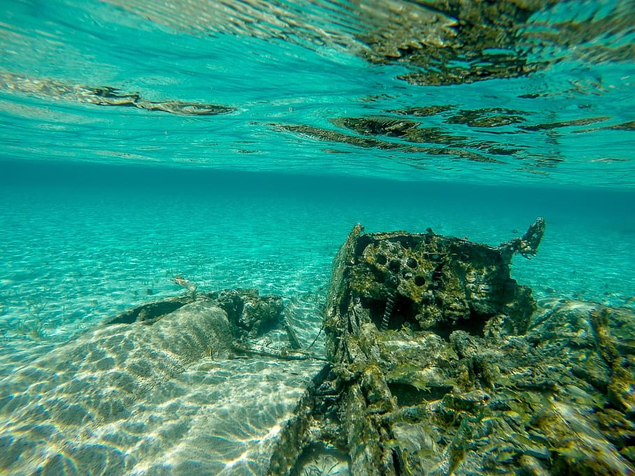
4.海底に没した、高知“黒田郡(くろだごおり)”
「地震による地殻変動によって地盤沈下が起き広範な地域が海の底に没した」と記されている1099年に発生した上記「康和南海地震」であるが、実はその前から高知県には「海の底に没した村」に関する伝承があった。「地震によって一夜にして水没した幻の村、『黒田郡(くろだごおり)』」である。
日本列島が位置する大陸の「ユーラシアプレート」の下に、南側から海洋プレートである「フィリピン海プレート」が接して年間数㎝の割合で沈み込んでいる場所を「南海トラフ」というが、その大変動が「南海トラフ大地震」として、100~150年間隔で繰り返し発生している。
上図また下図でも解るとおり、その「南海トラフ」変動の影響を直接、そして非常に受けやすい場所に高知県が存在しているため、高知県の沿岸部には、地震によって水没した集落の伝承や、海底に沈んでいる人工物の情報が各地に残されている。
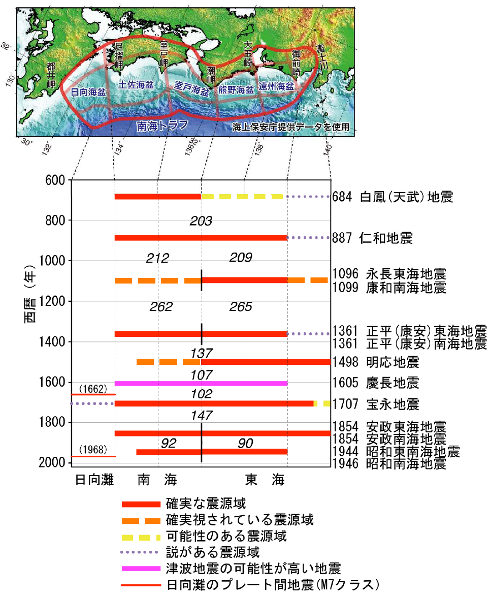
過去に発生した南海トラフ地震の震源域の時空間分布
Spatial and temporal distribution of the epicenter areas of past Nankai Trough earthquakes
(出典:「気象庁ホームページ」・「南海トラフの地震活動の長期評価(第二版)」(地震調査研究推進本部))
(Source: Japan Meteorological Agency (JMA )website,
“Long-term Evaluation of Seismic Activity in the Nankai Trough (Second Edition)” (Headquarters for Earthquake Research Promotion))
なかでも有名な伝承が「黒田郡」という集落が「一夜にして海の底に沈んだ」というものである。壬申の乱に勝利して即位した天武天皇の時代、684年に発生した白鳳(天武)地震によって「一夜にして海の底に沈んだ集落、『黒田郡』」の伝承が各地に残っている。
「白鳳(天武)地震によって水没したため、内陸の現在地に移った」という由来を持つ社寺もいくつかある。「黒田郡」そのもの名称の記述は無いが、「国立国会図書館デジタルコレクション」で「日本書紀」の天武天皇の時代の箇所を見ると、白鳳(天武)地震に関して「土佐国田苑五十余万頃没為海」(土佐国の田苑(はたけ)五十余万頃(約12㎢)あまり沒れて海となれり」と記述されている。
「黒田郡」以外にも巨大地震によって集落が水没したという記録、伝承は日本各地に残されている。1498年の「明応地震」によって、静岡県の焼津で起きた集落の水没、1586年(天正13年)の地震によって、滋賀県長浜市西浜地域にあった「千軒の集落が水没した」等がある。東日本大震災で有名になった「津波てんでんこ」と同様、このような地震被害の記録は、後世に防災意識を促す機能的役割が重視され、これまでこのような「記録伝承」を科学的に検証した事例は多くなく、「新たな地震への備え」という役割を十分に発揮できていないのが現状ではないかと思われる。
「瀬戸内海放送(KSB)」の公式YouTubeサイトには、「高知県では『黒田郡』という村が地震で海に沈んだという伝説が各地に残されていますがどこにあったのかはわかっていません。南海地震による地盤沈下に備えるため、この村を探している研究者の取り組みを取材しました」として、「南海トラフ巨大地震 “海に沈んだ村”研究に密着」と題したYouTube番組が載っている。⇒ https://www.youtube.com/watch?v=YFGGaP8esF4
5.防災科学技術研究所(防災科研:NIED)
昨年2020年3月14日本コラムに投稿した「RM 26ー東日本大震災の前震-地震ハザードステーション(J-SHIS)」で「防災科学技術研究所(防災科研)」のことを記したが、この防災科研とは、防災に関する科学技術の研究を行う、文部科学省所管の国立研究開発法人である。1963年4月、当時の「科学技術庁」の附属機関として設立された「国立防災科学技術センター」から改組、拡大された防災に関する科学技術の研究を行う機関であり、本部は茨城県つくば市にあり、全国各地に実験施設や観測施設を所有している。
この「防災科研(NIED)」のホームページにある「J-SHIS:地震ハザードステーション」は秀逸であり、地震の発生源となる、「主要活断層帯」、「その他活断層帯」、「海溝型地震震源断層」、「海溝型地震発生領域」、「主要活断層帯地表トレース」等に関して、全国マップの中で詳述、地震による影響を受ける地域を、今後30年間の期間で「震度5弱以上」、「震度5強以上」、「震度6弱以上」、「震度6強以上」に別けて、それぞれの揺れに見舞われる確率の分布予想図を掲載、地震によって自社に及ぶ影響が推定できるものとなっている。
●「防災科研(NIED)」J-SHIS:地震ハザードステーション・マップ
この防災科研が、高知、宮崎両県沖の海底で地震・津波観測システム「N-net(エヌネット)」の設置を進めている。南海トラフ巨大地震に備えた海底観測網整備の一環で、2024年の稼働を目指している。北海道から東日本太平洋沖に対して防災科研が設置した「S-net(エスネット)」、静岡県沖に東海地震のために設置された「気象庁の観測システム」、熊野灘から紀伊水道沖に防災科研が設置した「DONET(ドゥネット)」に加え、このN-netが揃うことによって、太平洋沖の観測空白域が解消して、従来より「津波の高さを最大20分、地震を約20秒早く検知する体制」が整うことになる。
この新しく高知県沖から宮崎県沖にかけて設置されるN-netは地震計と水圧計を1600キロの海底ケーブル2本で接続して、データを高知県室戸市と宮崎県串間市の陸上局に送信して、津波警報や地震警報に活かしていくものであり、南海トラフ巨大地震が発生した場合も早期の避難が可能になると期待されているシステムである。
6.政府地震調査研究推進本部の所見
阪神・淡路大震災の経験を活かして、地震に関する情報を政府として調査、提供するために設立された、「政府地震調査研究推進本部」のホームページには「次に発生する地震については」という項目に以下が記されている。
前述のように、過去に南海トラフで起きた大地震は多様性があるため、次に発生する地震の震源域の広がりを正確に予測することは、現時点の科学的知見では困難です。
歴史記録の多くは、南海地域(評価対象領域のうち、潮岬より西側の領域)で発生する地震、東海地域(評価対象領域のうち、潮岬より東側の領域)で発生する地震、両域でほぼ同時に発生する地震、に大別できます。
地震が同時に発生しない場合でも、数年以内の差でもう一方の領域で地震が発生しています。繰り返し間隔の長さと比較すると、これらはほぼ同時に活動しているとみなせます。そこで、本評価では、南海トラフを、南海・東南海領域という区分をせず、南海トラフ全体を一つの領域として、地震発生の可能性を評価しました。
次の地震が発生するまでの間隔については、時間予測モデル(用語解説参照)が成立すると仮定し、室津港(高知県)の隆起量をもとに88.2年と推定しました。昭和東南海・南海地震の発生から既に約70年が経過しており、次の大地震の切迫性が高まっていると言えます。
大地震の発生確率については、震源域の多様性などの複雑な発生過程を説明するモデルは確立されていないため、従来の評価方法を踏襲して、計算を行いました。この結果、今後30年以内の地震発生確率は60~70%となりました。
今回のまとめ
現在の地球物理学の定説では、3億年前、地球上には、「パンゲア」と呼ばれる1つの大陸が存在、それが2億年前分裂を始めたとされている。その後の分裂により、10数枚になったとされている地球を覆う「プレート」であるが、1つのプレート内で移動速度が異なる部分があることが発見され、それでは理論に適合しないために考え出された理論が「小規模な40数枚の小規模プレートが存在する」という考え方である。更に最近では、この小規模なプレートも細かく「ブロック分け」されていて、「その境目で大地震が発生する」ということが解ってきた。
このプレートの移動に応じて、上に乗った陸地も同じく移動している。ハワイは、1年間に約8cmずつ日本に近づいていると言われているのがこのことである。また、このプレートが移動する理論「プレートテクトニクス(プレート理論)」こそが「プレート型大地震発生の有力な理論的裏付け」となっているのである。
プレートに乗った大陸どうしが衝突することもある。インドが、豪州沖から移動してきて、ユーラシアプレートに衝突、そのエネルギーで大地に皺が誕生、「ヒマラヤ山脈」ができた。小規模な例であるが、「伊豆半島」も衝突によって合体したものである。こう記していくと、「プレートは地球の表面を移動し続ける」と考えられるが、「原料」であるマグマは、海底火山(海嶺)から生み出され、凝固してプレートを構成する。そして、移動し、最終的にはまた深海の海溝深くに沈み込んでいって、消失するのである。
このプレートには、「大陸側のプレート」と「海側のプレート」がある。日本を囲むプレートでは、大陸側が「ユーラシアプレート」と「北米プレート」であり、海側が「太平洋プレート」と「フィリピン海プレート」である。この4つのプレートの上に「乗っている」のが日本である。移動する「プレート」が4つもある世界でも希な場所が日本列島である、だから地震が頻発するのである。
海洋プレートは、大陸プレートよりも強固で密度が高いため、2つのプレートが衝突すると海洋プレートは大陸プレートの下に沈んでいく。太平洋プレートが北米プレートの下に沈み込んでいく際に発生した地震が「東日本大震災」であり、フィリピン海プレートがユーラシアプレートの下に沈み込んでいて、その接地面を「南海トラフ」と言い沈み込みの際に発生する現象が、その発生が強く懸念されている「南海トラフ大地震」である。
「温故知新」とは言い古された言葉であるが、「満足な予知ができない事象」に対してはこれほど重要な言葉はないであろう。古来起きた事象を知り、今後起こる可能性のあることを予測してその事態に備える。この言葉こそ「地震リスクマネジメント」の本質そのものを示している。過去にどんな地震があり、どんな損害が発生したか、これを識ることは重要な「将来への備え」になる。
この意味で、古文書に限らず、「津波の被害を記した石碑である『地震碑』」、更には古老の言い伝えでさえ、「ビッグデータ化」していくべきではないかと考えている。そのためには、「科学的なデータ観測」のみならず、「歴史学」の知見を大いに活用していくべきと筆者は考えるものであるが、幸いなことにその学問分野が拡がりを見せている。「地震考古学」という新しい概念を提唱した、地震考古学者寒川旭(さんがわ あきら)氏による、この講演にその姿を見ることができる。⇒●「産総研サイエンスカフェ in 関西「21世紀の巨大地震を考える -歴史から探る関西の地震-」(産総研公式YouTube)
損害保険の世界では、「事故などで対象物が物理的影響を被ること」を「損害」といい、「損害を被った結果、その対象と一定の関係がある人に与える経済的影響のこと」を「損失」というが、「地震リスク」という「損失を被る可能性」である不確定な要素を保険料というコストとして確定させる仕組みである「地震保険」を活用することによって「企業経営の不確実性」を減じていくことは、重要な経営戦略である。
しかし、「地震保険」を利用したとしても、単なる地震による建物等の損壊というリスクだけではなく、「高知『黒田郡』のように大規模な地殻変動が起きて海底に没すること=全損」が起きる可能性もよく検討した地震保険でなければその意味を成さない地域的特性にも着目する必要がある。
東日本大震災のとき飛び交った「想定外」という言葉を発しないためにも、「キャプティブ」という仕組みを上手く活用して、通常得られる地震保険を「補償金額、補償内容、補償範囲の面から充実させていくこと」、また地震保険を単なるコストにせず「リスクを収益にさえ変えていくこと」、これらもまた重要な経営戦略になるのではないだろうか。
執筆・翻訳者:羽谷 信一郎
English Translation
Captive (CA) 31 Great Nankai Trough Earthquake (Kochi “Kuroda-gori” sinking)
The following article was distributed by Kyodo News on September 3, 2021.
A team led by the National Institute of Advanced Industrial Science and Technology (AIST) has confirmed traces that indicate that a massive earthquake of unknown magnitude (M) 8.5 occurred off the coast of the Boso Peninsula about 1,000 years ago during the Heian-Kamakura period (794-1185), and that the Kujukuri beach area in Chiba Prefecture may have been hit by a massive tsunami.
The epicenter of the earthquake may be at the boundary between the Philippine Sea Plate and the Pacific Plate, which is located 20 to 50 kilometers deep beneath the Boso Peninsula, and shifting by about 10 meters deforms the sea floor and generates a tsunami. It seems that the area near the coast subsided due to the movement of the fault, and the inundation area of the tsunami expanded.
1. The Three Great Earthquakes of the Heian Period
The history of full-scale recording, observation, and prediction of earthquakes is only about 100 years old, and everyone agrees that data on local origins and ancient earthquakes is extremely important for predicting future earthquakes.
In the Heian period (794-1185), ”Nihon Sandai Jitsuroku”, a historical book compiled mainly by Michizane Sugawara , a famous god of learning, it is written that there were major earthquakes in present-day Kanagawa, Tokyo, and Saitama prefectures, and that “the number of crushing deaths was uncountable”. This was the Jogan Earthquake. It is noteworthy that this earthquake was followed by two more major earthquakes.
In 869, the Jogan Earthquake occurred.
In 878, the Gangyou earthquake occurred.
In 887, the Ninna Earthquake occurred.
The “Jogan Earthquake” was a huge earthquake that occurred off the Pacific coast of Tohoku with a magnitude of more than 8 on the Richter scale, and it is said that the Great East Japan Earthquake of 2011 was a repeat of the Jogan Earthquake. Nine years later was the Gangyo Earthquake, which was estimated to have a magnitude of over 7.4 and caused great damage in Sagami and Musashi provinces (the southern part of what is now the Kanto region).
If we assume that the Jogan Earthquake was the Great East Japan Earthquake of 2011, some people are concerned about the reoccurrence of the Gangyo Furthermore, nine years after the Gangyo Earthquake, the Ninna Earthquake, a huge earthquake with an estimated magnitude of 8.6, occurred in the Nankai Trough, which raises serious concerns about a major earthquake in the Nankai Trough.
2. Major earthquakes in the Heian and Kamakura periods
The Heian period, which began in 794 A.D., changed in old school education until 1192, and in recent school education until 1185, but with the progress in the establishment of the Kamakura shogunate, it is taught that “the Kamakura period began thereafter”.
If we look at the Kyodo News article at the beginning of this article, “An unknown massive earthquake estimated to be around 8.5 on the Richter scale occurred off the coast of the Boso Peninsula during the Heian-Kamakura period about 1,000 years ago,” we can see that the massive earthquakes other than the 869 Jogan earthquake, the 878 Gangyo earthquake, and the 887 Ninna earthquake mentioned in 1. above “occurred somewhere between the Heian and Kamakura periods”.
I checked the data in the book “Huge Earthquakes in the Middle Ages (Rekishi Bunka Library)” by Toshifumi Yata and other datum, and the following is a list of major earthquakes that occurred between the late Heian period (900) and the Kamakura period (1192-1333).
May 17, 938 (April 15, Shouhei 8) Kyoto earthquake: M (magnitude) 7 or so
July 17, 976 (June 18, Tenen 4) Yamashiro-Omi Earthquake: M6.7 or greater
June 10, 1026 (May 23, Manju 3) Manju earthquake: estimated M7.5-7.8
June 4, 1088 (May 13, Kanji 2) Sanriku earthquake and tsunami: M unknown
Dec. 11, 1096 (Nov. 24, Kaho 3) Eichou earthquake: M8 to 8.5
Feb. 16, 1099 (Jan. 24, Shotoku 3) Ko-wa Nankai Earthquake: M unknown
September 19, 1154 (August 10, Ninpei 4) Toyama earthquake: M unknown
August 6, 1185 (July 9, Genryaku 2) Bunji earthquake: M7.4 or so
3. Damage in Tosa (Kochi) caused by the Ko-wa Nankai Earthquake
According to the above-mentioned “Huge Earthquakes in the Middle Ages (Rekishi Bunka Library),” earthquakes like the “foreshocks of later major earthquakes” occurred in January, April, and June in 1098 (Shotoku 2), and the main earthquake, the ” Ko-wa Nankai Earthquake,” occurred in January 1099 (Shotoku 3). The “Go Nijo Shi Tsuki,” which is the basis of this report, states that “Kofukuji Temple in Nara and Tennoji Temple in Osaka were severely damaged,” but the “Chronological Table of Science” edited by the National Astronomical Observatory of Japan, National Institutes of Natural Sciences, states that “Kofukuji Temple and Settsu Tennoji Temple were damaged.The “Chronology of Science” compiled by the National Astronomical Observatory of Japan’s National Institutes of Natural Sciences says, “Kofukuji Temple and Settsu Tennoji Temple were damaged. And in Tosa, there was a tsunami that sank the entire town of Tosa into the sea.
Due to this great earthquake and the epidemic that was occurring at the same time, the name of Shotoku was changed to ” Ko-wa ” on August 28, Shotoku 3.
As for the damage caused by the tsunami in Tosa (present-day Kochi Prefecture), the following is written in the book “Huge Earthquakes in the Middle Ages (Rekishi Bunka Library)”.
Damage in Tosa
What is the basis for the article in the “Science Chronology” that says, “In Tosa, more than 1,000 rice paddies all sink into the sea”? It is the following article.
At the time of the earthquake on the fourth day of the fourth month of the second year of the Ko-wa, all of the more than 1,000 rice paddies in Japan became submerged in the sea. The shrine’s territory, Go-on-sho, was close to the beach, and the same was true for the rest.
The article is from the Kanenaka Shoshi Sebunsho (a document on the back of a piece of paper in the collection of the National Museum of Japanese History, handwritten in November-December 1283), which was issued to Tosa Province to convey an imperial order.
The “shrine territory” seen in the article refers to the Kamomiosha shrine territory. Ushioe-sho, the territory of the Kamomiosha, is located south of JR Kochi Station in present-day Kochi City, Kochi Prefecture. The area was close to the seashore in the Middle Ages. It is written that this Ushioe-sho and 1,000 rice paddies in Tosa Province sank into the sea.
In 1090, Kamomiosha Shrine established Shioesho as a manor in what is now Kochi City, but the earthquake submerged 1,000 rice paddies, or about 10,000㎢ of rice fields, and Shioesho was severely damaged, so it was moved to an alternative site the following year. “10㎢” means that most of the coastal area of present-day Kochi City was “submerged to the bottom of the sea” due to crustal movement caused by the earthquake.
However, this document was written almost 200 years after the Ko-wa Nankai earthquake, and earthquakes outside the Kinai region, such as in Kyoto, which was the capital, would not be recorded if there was no damage in Kyoto. Therefore, it cannot be said that there is no problem with the eligibility of the data, but it is considered to be highly credible since it is written in an official document called the “official proclamation to Tosa Province (a document signed by a high-ranking officer and issued to convey imperial orders).
More importantly, it is important to note that what is described in this document is not just “tsunami damage” but “sinking of more than 1,000 townships of rice paddies into the sea = the land subsidence caused by the great earthquake spread over a wide area, submerging a vast area of rice paddies of more than 10㎢ into the bottom of the sea”.
4. Kochi’s “Kuroda Goori (Village)” submerged in the sea bed
It is written that “crustal movement caused by the earthquake led to land subsidence, and a wide area was submerged at the bottom of the sea”. In fact, even before that, there was a tradition in Kochi Prefecture about a village submerged at the bottom of the sea: “Kuroda Goori,” a fantastic village that was submerged overnight by an earthquake.
The Nankai Trough is a place where the Philippine Sea Plate, an oceanic plate, is sinking at a rate of several centimeters per year from the south under the Eurasian Plate, the continental plate on which the Japanese archipelago is located. The big change is the “Nankai Trough Earthquake”, which occurs repeatedly at 100-150 year intervals.
One of the most famous legends is that a village called Kuroda Goori sank to the bottom of the sea overnight. In the era of Emperor Temmu, who ascended to the throne after winning the Jinshin War, the Hakuho (Temmu) Earthquake occurred in 684, and the legend of “Kuroda-Goori,” a village that sank to the bottom of the sea overnight, remains in many places.
“There are also some shrines and temples that say that they were submerged by the Hakuho (Tenmu) earthquake and moved inland to their present location. There is no description of “Kuroda-Goori” itself, but according to the Digital Collection of the National Diet Library, a section of the Nihon Shoki (Chronicles of Japan) from the reign of Emperor Temmu describes the Hakuho (Tenmu) Earthquake as “the sea that submerged the Tosa Province’s rice fields around 500,000, around 12㎢.
In addition to “Kuroda-Goori”, there are other records and legends of villages submerged by huge earthquakes in various parts of Japan, such as the submergence of a village in Yaizu, Shizuoka Prefecture in 1498, and the submergence of a village of 1,000 houses in Nishihama, Nagahama City, Shiga Prefecture in 1586. As in the case of “Tsunami Tendenko,” which became famous after the Great East Japan Earthquake, records of earthquake damage such as these have been emphasized for their functional role in promoting disaster prevention awareness among future generations. It seems to me that the current situation is that the role of “preparing for new earthquakes” has not been fully demonstrated.
The official YouTube site of the “Seto Inland Sea Broadcasting (KSB)” says, “In Kochi Prefecture, there is a legend that a village called Kuroda-Goori sank into the sea after an earthquake, but it is not known where it was located. In order to prepare for land subsidence caused by the Nankai earthquake, we covered the efforts of researchers who are searching for this village.” The article describes a YouTube program titled “Nankai Trough Mega Earthquake: Close Research on ‘Village Sunk into the Sea'”. ⇒ https://www.youtube.com/watch?v=YFGGaP8esF4
5. National Research Institute for Earth Science and Disaster Prevention (NIED)
I wrote about the National Research Institute for Earth Science and Disaster Prevention (NIED) in my column “RM 26 – Foreshocks of the Great East Japan Earthquake – Earthquake Hazard Station (J-SHIS)” on March 14, 2020. NIED is a national research and development corporation under the jurisdiction of the Mion. inistry of Education, Culture, Sports, Science and Technology (MEXT) that conducts research on science and technology related to disaster prevention, and was reorganized and expanded from the National Research Center for Earth Science and Disaster Prevention, which was established in April 1963 as an affiliate of the then Science and Technology Agency. Its headquarters is located in Tsukuba City, Ibaraki Prefecture, and it has experimental and observation facilities all over the country.
The “J-SHIS: Earthquake Hazard Station” on the website of the National Research Institute for Earth Science and Disaster Prevention (NIED) is excellent, and provides a detailed description of the “major active fault zones”, “other active fault zones”, “trench earthquake source faults”, “trench earthquake occurrence areas”, and “surface traces of major active fault zones”, which are the sources of earthquakes, on a nationwide map. The map shows the distribution of the probability of each type of tremor in the areas to be affected by earthquakes over the next 30 years, classified as “seismic intensity 5 or lower,” “seismic intensity 5 or higher,” “seismic intensity 6 or lower,” and “seismic intensity 6 or higher.
The NIED is currently installing the N-net earthquake and tsunami observation system on the seabed off the coast of Kochi and Miyazaki prefectures. The project is part of the development of a submarine observation network in preparation for a massive earthquake in the Nankai Trough, and is expected to be operational in 2024. The N-net is in addition to the S-net installed by the Disaster Prevention Research Institute (DRI) off the Pacific coast of eastern Japan from Hokkaido, the Japan Meteorological Agency’s observation system for the Tokai earthquake off Shizuoka Prefecture, and in addition to DONET, which was set up by the National Research Institute for Earth Science and Disaster Prevention (NIED) off the coast of Kumano-nada and the Kii Channel, the N-net will eliminate the blank observation area off the Pacific Ocean and provide a system to detect tsunami heights up to 20 minutes earlier and earthquakes about 20 seconds earlier than before.
The new N-net system, which will be installed off the coast of Kochi and Miyazaki prefectures, will connect seismographs and water pressure gauges with two 1,600-km submarine cables and transmit the data to land stations in Muroto City, Kochi Prefecture, and Kushima City, Miyazaki Prefecture, for tsunami and earthquake warnings.
6. Opinion of the Headquarters for Earthquake Research Promotion, Government of Japan
On the website of the Headquarters for Earthquake Research Promotion, which was established to investigate and provide information on earthquakes as a governmental organization based on the experience of the Great Hanshin-Awaji Earthquake, the following is described in the section titled “What to do about the next earthquake”.
As mentioned above, due to the diversity of major earthquakes that have occurred in the Nankai Trough in the past, it is difficult with the current scientific knowledge to accurately predict the extent of the epicenter of the next earthquake.
Most of the historical records can be divided into three major categories: earthquakes that occur in the Nankai region (west of Cape Ushiomisaki in the area under evaluation), earthquakes that occur in the Tokai region (east of Cape Ushiomisaki in the area under evaluation), and earthquakes that occur almost simultaneously in both regions.
Even if the earthquakes do not occur at the same time, they occur within a few years of each other in the other region. In comparison with the length of the repetition interval, these earthquakes are considered to be active almost simultaneously. Therefore, in this evaluation, the Nankai Trough is not divided into the Nankai and Tonankai regions, but the entire Nankai Trough is considered as one region, and the possibility of earthquake occurrence is evaluated.
The interval between the occurrence of the next earthquake is estimated to be 88.2 years, based on the uplift of Murotsu Port (Kochi Prefecture), assuming that the time prediction model (see Glossary) is valid. About 70 years have already passed since the occurrence of the Showa-Tonankai and Nankai earthquakes, and it can be said that the imminence of the next major earthquake is increasing.
As for the probability of the occurrence of a major earthquake, since no model has been established to explain the complex process of occurrence such as the diversity of the epicentral regions, we followed the conventional evaluation method and performed the calculations. As a result, the probability of an earthquake occurring within the next 30 years is 60-70%.
Summary of this issue
According to the current theory of geophysics, 300 million years ago, there existed a single continent called “Pangaea” on the earth, which began to break up 200 million years ago. As a result of the subsequent breakup, the Earth is said to have been covered by a dozen or so plates, but it was discovered that within each plate, there were parts that moved at different speeds. Since this did not conform to the theory, the theory that there were 40 or so small-scale plates was devised. More recently, it has been discovered that these smaller plates are also divided into “smaller blocks”, and that major earthquakes occur at the borders between these blocks.
As these plates move, the land on top of them moves as well. This is why it is said that Hawaii is getting closer to Japan by about 8 cm per year. This theory of plate movement, called plate tectonics (plate theory), is a powerful theoretical basis for the occurrence of large plate-type earthquakes.
There are times when continents on plates collide with each other. When India moved from off the coast of Australia and collided with the Eurasian plate, the energy from the collision created wrinkles in the earth and the Himalayas were formed. The Izu Peninsula was also formed by a collision, although this is a small-scale example. Magma, the “raw material,” is produced by submarine volcanoes (ocean ridges) and solidifies to form plates, which then move and eventually sink deep into the ocean trenches and disappear.
There are two types of plates: continental plates and oceanic plates. The continental plates that surround Japan are the Eurasian Plate and the North American Plate, and the oceanic plates are the Pacific Plate and the Philippine Sea Plate. Japan sits on top of all four of these plates. The Japanese archipelago is one of the few places in the world where there are four moving plates, which is why earthquakes occur so frequently.
The oceanic plate is stronger and denser than the continental plate, so when the two plates collide, the oceanic plate sinks under the continental plate. The Great East Japan Earthquake occurred when the Pacific Plate sank beneath the North American Plate, and the Nankai Trough is a phenomenon that occurs when the Philippine Sea Plate sinks beneath the Eurasian Plate. This is the “Nankai Trough Earthquake,” the occurrence of which is strongly feared.
The phrase “learning from the past” is an old one, but it is probably the most important phrase when it comes to events that cannot be predicted satisfactorily. We need to know what has happened in the past, predict what may happen in the future, and prepare for it. This is the very essence of “earthquake risk management”. Knowing what kind of earthquakes have occurred in the past and what kind of damage they have caused is an important part of “preparing for the future”.
In this sense, I believe that not only old documents, but also “earthquake monuments,” which are stone monuments describing the damage caused by tsunamis, and even the legends of old people, should be converted into “big data”. In order to do so, I believe that not only scientific data observation, but also the knowledge of historical studies should be utilized, and fortunately, this academic field is expanding, as can be seen in this lecture by earthquake archaeologist Akira Sangawa, who proposed the new concept of “earthquake archaeology”. ⇒ 新大阪学事始「地震考古学から見た大阪地層探検」3「9世紀地震と現在」寒川旭さんレジメつき – YouTube ● “AIST Science Cafe in Kansai “Thinking about Giant Earthquakes in the 21st Century -Earthquakes in Kansai Explored from History-” (AIST official YouTube)
In the world of non-life insurance, the term “damage” refers to the physical impact of an accident on an object, and the term “loss” refers to the economic impact on people who have a certain relationship with the object as a result of the damage.
However, even if earthquake insurance is used, it is necessary to pay attention to the regional characteristics that make it meaningless unless the earthquake insurance carefully considers not only the risk of damage to buildings caused by earthquakes, but also the possibility of total loss due to submersion in the seabed caused by large-scale crustal movement, such as in Kochi’s Kuroda-Goori.
In order to avoid using the word “unexpected,” which was frequently used in the aftermath of the Great East Japan Earthquake, it is important to make good use of the “captive” mechanism to “enhance the amount, content, and scope of coverage” of earthquake insurance that is normally available, and to “turn risk into profit” instead of making earthquake insurance a mere cost. I believe that these will also be important management strategies.
Author/translator: Shinichiro Hatani