
リスク対応策 2022.01.31
RM68「地名に潜むリスク」へ備えるキャプティブ 3(「干拓地」東京)
目次
Copyright © Shinichiro Hatani 2022 All rights reserved
For those who prefer to read this column in English, the Japanese text is followed by a British English translation, so please scroll down to the bottom of the Japanese text.
NHKの人気番組で、筆者も欠かさず見ている「ブラタモリ」。昨年、2021年10月23日の放送では、「つくば〜つくばは“日本の姿”をどう解き明かす?〜」と題して、茨城県筑波研究学園都市にある、国家地図の作成をおこなう国土交通省の特別機関「国土地理院」と、地質調査の専門機関である国立研究開発法人「産業技術総合研究所(「産総研」:地質調査総合センター)」、この二つの専門機関を特集した。
東日本大震災発生の前年、「来たるべき大震災の発生」を予測する「仙台平野の地質調査の報告書」を国に提出したことで知られる、「産業技術総合研究所(「産総研」:地質調査総合センター)」と国土地理院は、「地震予知に関して密接不可分な関係にある」と考えている筆者は、NHKのこの焦点の絞り方は秀逸であると感じた。
国土の有様を詳細に記す地図には「過去の地震の痕跡」も具に記されている。その「過去の痕跡と謂れ」にしたがって「地質調査」をおこない「津波の痕跡」を発見、検証することができれば、「大規模地震リスク」の解明に大いに資することとなり、今の科学では不可能とされている「地震予知」への途が開ける可能性があるからである。
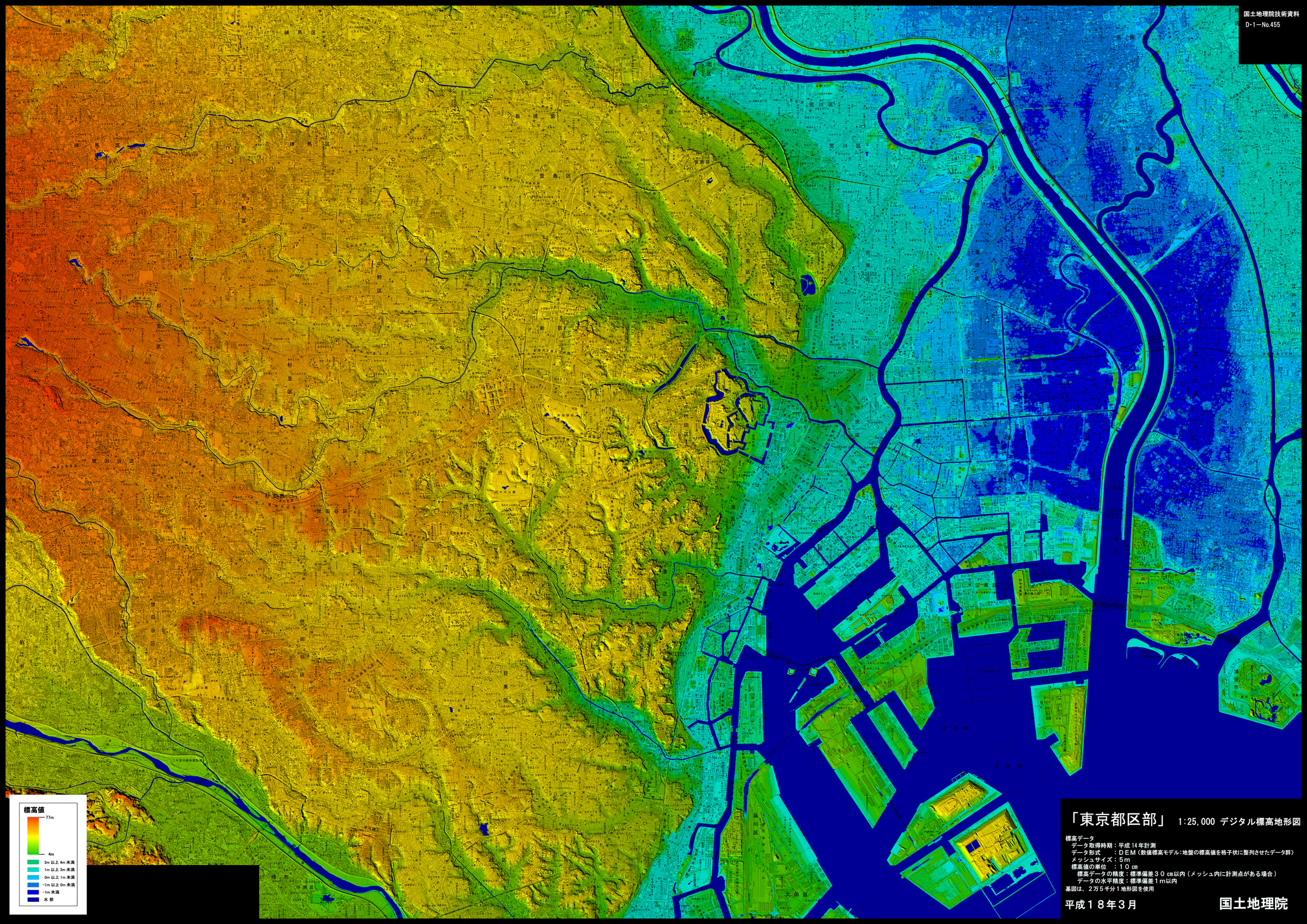
上図は、国土地理院のホームページで公開されている「デジタル標高地形図」の「東京都区部」のページから引用したものである。
The above figure is taken from the “Tokyo Metropolitan Area” page of the “Digital Elevation Topographic Map” available on the Geospatial Information Authority of Japan(GSI) website.
この中心に小さく青い線で囲まれている円形の場所は、現在の皇居、旧江戸城である。旧江戸城の東側、現在の丸の内、日比谷から新橋方面に、標高(海抜)1m未満を示す「水色」の帯が細長く広がっているのが解る。この一帯は、昔「日比谷入江」と呼ばれ、「海が、陸地に向かって入り込んでいる場所:入江」であり、家康が江戸に入ってしばらくは、江戸城に隣接しているため「重要な軍港」として使われていた場所である。現代でも東京湾周辺には「谷津干潟」等の干潟が拡がっているが、江戸時代までは「江戸城のお堀まで、幅数百メートルの海域が細長く入り込んでいた」のである。
1590年、天下統一を目指していた豊臣秀吉は、小田原城を本拠として関東全域を治めていた北条家に対し、「上洛に応えなかった」という理由で、全国の武士を動員、世に言う「小田原征伐」をおこない、同年7月北条早雲以来五代に及んだ北条氏を滅亡させた。この戦いで軍功をあげた徳川家康には「関東の平定とその北、東北への睨みをきかせる」ため、それまでの三河119万石から、北条家の旧領250万石を与えるという大幅な加増をおこない、家康はこれに従い、同年8月江戸に入った。ただ、当時は「秀吉の時代」であり、家康は政治の中心地であった上方にいることの方が実際には多かった。それが変化したのが、1600年の関ヶ原の戦いに勝利して「天下人」となり、1603年征夷大将軍の宣下を受け、江戸に幕府を開いた時である。
当時、江戸の多くの場所は湿地、低地であった。幕府を開くや否や始めたのが「住居の建設場所の確保、大名屋敷の敷地の確保、これらの街並みの整備のため、湿地、低地を埋め立てること」であった。その「盛り土」を確保した場所が、いまでも「高台」であり地名にもそれが残っている「神田駿河台」である。当時は、「神田山」と呼ばれたこの山を切り崩し、その土砂を使って、まず江戸城近くの「日比谷入江」の埋め立てをおこなった。そして、他の湿地、低地を埋め立てた後、これらの「居住場所」を繋ぐ「運河」の開発をおこなっていった。
上図で、「日比谷入江」の前方、標高3メートル以上の「緑色」になっている半島状の陸地は、現在の日本橋、京橋地域であり、当時は「江戸前島」という砂州が南にのびていた場所であった。
「江戸」に関する地名の由来については、諸説あるが、「入江」(海)の「戸」(入口)を意味するところから「江戸」となったとする説が有力だと言われている。つまり、江戸、今の東京は「海と密接不可分な関係」にあったのである。
筆者が大学を卒業して勤務した大手外資系損害保険会社が、かつて本社ビルを有していた場所は「千代田区丸の内1-1-3」であった。その真向かいに「和田倉門」という地名がある。この「和田」は、人名ではなく「わだつみ」の漢字表記である。このわだつみとは日本の神話で「海の神」を指し、このことからから「海」を意味しているのである。つまり、この「日比谷入江」の突端である「和田倉門」は、「海の前に倉があったということを意味する地名」であり、現在の東京の中心部は、400年前には「海だった」のである。
1.ヤン・ヨーステン
1600年の「関ヶ原の戦い」、1614年から1615年にかけての「大坂(冬・夏)の陣」、これらの背後では、世界の植民地から得る豊富な銀によって当時世界最大の帝国となった「カトリック教(旧教)国、スペイン」、そしてスペインの銀独占を阻止したいと考える「東インド会社」を有する新興貿易国家の「プロテスタント教(新教)国、オランダ」、この2国の世界の覇権争いが、当時、世界全体の3分の1の産出量を誇った日本の「銀」を巡って蠢いていた。つまり、日本の戦国時代は、単に徳川、豊臣の戦いではなく、世界の覇権国家が日本を舞台にして、「世界初の国際通貨」として誕生した「銀貨」を巡る争いでもあったのである。
配下に有力キリシタン大名を抱え、スペインと密接な関係を保っていた豊臣秀頼。これに対して、「天下人」徳川家康は、航海長であった英国人ウイリアム・アダムス(三浦按針)とともにオランダ船「リーフデ号」に乗り込み、1600年豊後(大分県)に漂着したオランダ人ヤン・ヨーステン(日本名:耶揚子(やようす))を通じて、オランダとの関係を深くしていった。
彼は、徳川家康に深く信任され、「江戸城内堀沿い」に現在の地名「八重洲」のもととなった屋敷をあてがわれた。後年、日本の鎖国が長年続くなか、唯一海外に門戸を開いていた長崎の出島。この出島を管理していたのは「オランダ東インド会社」であり、また「オランダ貿易のみが明治初期まで続いた背景」はここにある。
ヤン・ヨーステンの音韻から、「八重洲」の名称がつくられたのあろうが、なぜ「ス」に「洲」があてられたのか。江戸が「水運」で成り立っていたからなのか、それとも「洲=海=海外」ということか、興味深い文字であり、「江戸、現在の東京は、水とは切っても切れない関係を匂わせる文字」である。
2.江戸湊
一昨年、2020年11月21日投稿した「RM50 地名に潜むリスク 1 (縄文海進)」に「洲」について次のように記した。
「港」以外に、「みなと」と呼ばれる漢字に「湊」がある、「水門」を意味する言葉である。古くは、港湾施設のうち、水上部分を「港」、陸上部分を「湊」と呼んだ。
この湊を冠する地名が、東京都中央区京橋地域にある。古くから、鐵砲洲稲荷神社の門前町として賑わいを見せている町であり、地域内に本湊町、船松町という町名があることからも推察できるが、江戸に物資を運び込む舟運の要所、「江戸湊」として栄えた街であった。
この「鐵砲洲稲荷神社」の「洲(す)」とは、「大辞泉」(「小学館」刊)によると、
「川・湖・海の底に土砂がたまって高くなり水面上に現れたもの」であり、「河口付近などの比較的浅い場所にできる」
とある。かつては「川であった」ということであり、昔の河川名にも「鉄砲洲川」があったが、1923年起きた関東大震災の瓦礫処理のため埋め立てられ、現在は鉄砲洲通となっている。
上記からも解るように、「八重洲」の「洲」は、「川を流れてきた砂が堆積してできた地」である。また、この「京橋」の名前は、嘗て存在した川に架かっていた橋に由来している。
徳川家康が江戸入りして始めた「干拓」と「運河づくり」でも解るとおり、江戸時代の「荷物を運搬する手段は船」であり、運河が生活に重要な役割を果たし、そのため運河、川に架かる橋が地名となった。徳川幕府が定めた五街道(東海道、中山道、日光街道、奥州街道、甲州街道)の起点を明治政府が踏襲、日本のあらゆる道路の起点「道路元標」が置かれた、日本を代表する金融街である「日本橋」と同様、京橋は江戸時代から「都心」であった場所であり、当時の高速交通手段である「船」を使う、海、川、運河と密接な関係があった場所ということが解る。
この日本橋にあった「魚市場」が、関東大震災の大きな被害を受けて移転した場所が「築地」である。2018年、市場は「豊洲」に移ったが、長く「魚市場」があったこの築地は、江戸時代に「地を埋めて築いた」ことに由来して「築地」と呼ばれている。
江戸時代末期、幕府は諸外国からの脅威に備えるため海軍力増強を目的として築地に、後年海軍「軍艦操練所」へと改称した「講武所」を設置した。明治に入り、築地近くの大名屋敷や軍艦操練所は明治政府に接収され、幕府の「講武所」の替わりに、後に「海軍兵学校」と改称した「海軍操練所」を創立、1887年広島「江田島」に移転するまで、築地には「海軍の最高教育機関」があったのである。
その理由は、1872年、築地にあった「松平定信の別邸」の場所に「海軍省」が創立されたことにある。屋敷庭園の築山には、「海軍卿の旗」(海軍大臣の前身「海軍卿」)が掲げられ、そのことから「旗山(きざん)」と呼称され、「海軍発祥の地」として記念碑が建立されている。
3.盛り土のリスク
昨年、2021年7月、静岡県熱海市で起きた「大規模な土石流」によって、「盛り土」の怖さは全国に知られるところとなった。熱海市の場合「斜面になされた盛り土」が発生させた土石流であったが、「地形の変更はそれを取り囲む自然環境を変化させる」という点では、「平地になされた盛り土」についても同じである。地盤の強度について相応の調査と対応が必要であることは論を待たないであろう。
以前のコラムに「文部科学省の特別機関である『地震調査研究推進本部』が公表している地盤データを基に、『ゲンダイネット』が地震を想定して、2012年1月作成した『揺れに強い東京の街ランキング』で、筆者が居住している多摩市が1位となった」と記したことがある。
その際使われた指標は、「表層地盤増幅率」であった。地震の揺れの強さは「規模」と「震源からの距離」によって異なるが、地震の規模と距離が同じでも、揺れの強さは、建物の立つ地盤の固さで大きく変わってくる。その地盤が堅固かどうか、「表層地盤」(土地の表層近くの浅い部分)の揺れの大きさを数値化したものが、「表層地盤増幅率」である。「揺れに強い東京の街ランキング」で算出された多摩市の数値は1.04であり、拙宅付近では1.02であった。
「表層地盤増幅率」とは、地表面近くに堆積した地層(表層地盤)の地震時の揺れの大きさを数値化、地震に対する地盤の強弱を示す数値である。同じ規模の地震が発生しても、その影響を受ける度合いは異なってくる、そのファクターは「地盤の強さ」である。この数値が大きいほど地盤は弱く、揺れは大きくなる。国立研究開発法人防災科学技術研究所(NIED)の分析では、「1.6以上で地盤が弱いことを示す」とされ、「2.0以上は特に揺れやすい」との評価である。
「地震ハザードステーション」の「地震ハザードカルテ」に地名を入力して「診断」を押してみたところ、東京駅は1.27、江戸時代「日比谷入江」を埋め立てた場所にある日比谷駅は1.51、銀座駅は1.41、新橋駅は1.52であった。江戸時代、水田をつくるため羽田村沖の干潟が干拓され、幕末に「江戸防衛の『羽田お台場』として砲台が置かれた場所」は、現在羽田空港となっている。干拓された土地の宿命か、第一、第二、第三ターミナル、すべての数値は1.41であった。築地から魚市場が移転した豊洲では1.87であった。
勿論、最近建築されているビルは、最新の建築技法によって耐震、免震の備えは十分されていると思うが、「築浅ではないビル」については「地震に対して相応の準備が必要であること」は、これらの「表層地盤増幅率」の数値からも読み取れる。
しかし、「盛り土」以上に地震・津波リスク、水災リスク等に関して強く懸念される場所が、冒頭の「デジタル標高地形図」(東京都区部)の右側、荒川を中心に東西に広がっている「青色」(標高-1m)の広大な一帯である。「地震ハザードカルテ」では、荒川区2丁目付近の「表層地盤増幅率」は2.2と弾き出された。
幸いなことに、大津波が発生しても「東京湾が護る形で存在している」ので、大津波の直接的な被害は食い止めることができるであろうが、問題は「液状化のリスク」であり、また「地震によって堤防が破壊されるリスク」である。東日本大震災では仙台空港内の地下トンネルが津波で水没した。
2009年、国の中央防災会議が、「大雨で荒川土手が北区で決壊した」と想定したミュレーションでは、地下鉄の地上出入り口に高さ1mの止水板を設置しても、この「青色」の地帯だけではなく、「東京都市部の22路線130駅、総延長約200kmの地下鉄網」のうち、「地下の線路網が水を運ぶ形になり、最大で17路線81駅、約121kmで改札階まで水没、地上では水が来ない駅も浸水する」という結果となったのである。
今回のまとめ
昨年、2021年1月13日、政府地震調査研究推進本部地震調査委員会は、「長期評価による地震発生確率値の更新について」を公表した。それによると、地震が起きていない期間が長くなるほど発生確率は上がることを理由として、静岡を含む南海トラフで40年以内にマグニチュード8~9クラスの地震、いわゆる「南海トラフ巨大地震」が起きる可能性を前年の「80%~90%」から「90%程度」に引き上げた。一方で、南海トラフ巨大地震が30年以内に発生する確率は「70%~80%」、20年以内に発生する確率は「50%~60%」に据え置かれた。
「地名は歴史の語り部である」と筆者は考えている。その土地の成り立ちと過去を名称に残しているからである。「遺跡に残された地震の痕跡調査」と、「古文書他の歴史資料のなかにある地震に関する記述」を照らし合わせて、地震の発生時期の推定や今後の地震予測を行う、地震学と考古学をあわせ持つ学問である地震考古学。この新しい学問を提唱した、産業技術総合研究所(産総研)名誉リサーチャーである寒川旭(さんがわ あきら)氏が著した「歴史から探る21世紀の巨大地震(朝日新書 朝日新聞出版刊)」の「カバーのそで」には、次の言葉が書かれている。
地震は待ったなしにやってくる。なのに、地震の予知はむずかしい。そこに、地震考古学の出番がある。文献や大地に刻まれている痕跡を分析することによって、その土地での過去の地震の頻度や大きさがわかってくる。2011年の東日本大震災を、9世紀の貞観地震に重ね合わせると、21世紀はまさに巨大地震に狙われる激動の時代ということになる。「首都圏」「南海トラフ」という国の根幹を揺さぶる地震が、実は、近くまで来ているのである。
同じ規模の地震が起きても、前述のとおり、地盤の「固い場所」と「柔らかい場所」では、その衝撃の度合いは大きく変わってくる。前者か後者かは、地名に多くのヒントが隠されている。「水、川、海」を表わす「沢、川、谷、池」などは、その場所の成り立ちが推測できるが、簡単に推測できないような地名もある。「赤」が付く地名がその一つである。この「赤」は、色を示すのではなく「垢(あか)がたまるように土砂が堆積した低湿地」のことを言うのである。「赤羽、赤堤」などである。冒頭記した「日比谷入江」に付いている「江」も同様。海、川を意味する「頻水地形」(頻繁に冠水する地形)に付けられている。江古田、一之江などである。
このような地名からその土地の成り立ちを考えながら企業が事業用地を購入することは、「ほとんど無い」と言っても過言ではないだろう。しかし、「2011年の巨大地震、東日本大震災によって、プレートが大きく動き、その影響は日本列島が位置する全てのプレートに影響を与え、地震が増加している」と言われている時が「いま」である。
「日本列島が動く時代」に入った「いま」、「地震保険は高いから保険は掛けない」という発想ではなく、新たな発想で対応策を練り実行すべき時ではないだろうか。「キャプティブは地震保険コストを大きく削減できるリスクマネジメント・ツール」であることは多くの事例で証明されている。「キャプティブの設立」をおこない、十分な補償内容と補償枠を持った地震保険を用意すべき時ではないだろうか。
そのときに備えて。「想定外でした」と言い訳を言わないで済むように。東日本大震災を受けてステークホルダーは企業経営者のリスクマネジメント対応に格段に厳しくなっているからである。
執筆・翻訳者:羽谷 信一郎
English Translation
Risk Management (RM) 68 – Captives prepared for “Risk in place names” 3 (“Reclaimed land”, Tokyo)
NHK’s popular TV programme “Bratamori”, which I watch without fail. Last year, on 23 October 2021, the programme was titled “Tsukuba – How does Tsukuba reveal the shape of Japan? 〜This year’s episode, titled “Tsukuba – How Tsukuba Reveals the Shape of Japan”, featured two specialist institutes in Tsukuba Science City, Ibaraki Prefecture: the Geospatial Information Authority of Japan (GSI), a special agency of the Ministry of Land, Infrastructure, Transport and Tourism that produces national maps, and the National Institute of Advanced Industrial Science and Technology (AIST), which specialises in geological surveys.
The Geospatial Information Authority of Japan (GSI) , and the National Institute of Advanced Industrial Science and Technology (AIST) which is known to have submitted a report on the geological survey of the Sendai Plain to the government the year before the Great East Japan Earthquake, predicting “the occurrence of the coming great earthquake”, are, in my opinion, “inextricably linked in terms of earthquake prediction”. NHK’s narrowing of the focus was therefore excellent.
The maps, which show the state of the country in detail, also show “traces of past earthquakes”. If we can discover and verify the traces of tsunamis by conducting geological surveys according to the traces and stories of the past, it will greatly contribute to the understanding of the risk of large-scale earthquakes, and may open the way to the prediction of earthquakes, which is considered impossible by current science.
The circular area surrounded by a small blue line in the centre is the present Imperial Palace, the former Edo Castle. On the east side of the former Edo Castle, from present-day Marunouchi and Hibiya to Shimbashi, you can see a long, narrow strip of light blue indicating an elevation (above sea level) of less than one meter. This area was called Hibiya Inlet in the olden days, and was used as an important military port for a while after Ieyasu’s arrival in Edo, as it was adjacent to Edo Castle. Even today, tidal flats such as the Yatsu Tidal Flat can be found in the vicinity of Tokyo Bay, but until the Edo period, there was a long, narrow stretch of water several hundred metres wide that ran right up to the moat of Edo Castle.
In 1590, Hideyoshi Toyotomi, who was aiming to unify the country, mobilized warriors from all over the country and carried out the so-called “Odawara Conquest” against the Hojo family, who ruled the whole Kanto region with Odawara Castle as their base, on the grounds that they had not responded to his request for a visit to Osaka. In July of the same year, five generations of the Hojo clan, including Hojo Soun, were destroyed. In July of the same year, five generations of the Hojo clan, including Soun Hojo, were destroyed. However, this was the “Age of Hideyoshi” and Ieyasu was in fact more likely to be in Osaka, the political centre of the country. This changed in 1600, when he won the Battle of Sekigahara, became a “Tenka Shogun”, was proclaimed a ” Conqueror Shogun of Japan” in 1603, and established the Shogunate in Edo.
At the time, much of Edo was marshy and low-lying. As soon as the Shogunate was established, he began to fill in the marshy and low-lying areas to make room for the construction of houses, the daimyo’s residences and the development of the city. Kanda Surugadai was the place to secure this “fill”, which is still a “high ground” and still remains in the name of the place. At the time, this mountain was called “Kanda-yama”, but it was cut down and the earth and sand from it were used to fill in the Hibiya Inlet near Edo Castle. Then, after reclaiming other wetlands and lowlands, they developed the canals that connected these “residential areas”.
In the map above, the peninsula-shaped land in front of the Hibiya Inlet at an elevation of more than 3 meters is the present-day Nihonbashi and Kyobashi areas, where a sandbar called “Edomaejima” used to extend southward.
There are many theories as to the origin of the name Edo, but the most popular is that it means “door” (entrance) to the “inlet” (sea), hence the name Edo. In other words, Edo, now Tokyo, had a “close and inseparable relationship with the sea”.
The head office of a major foreign non-life insurance company, where I started to work after graduating from university, used to be located at 1-1-3 Marunouchi, Chiyoda-ku. Directly across the street from the gate was a place called Wadakuramon. The name “Wada” is not a person’s name, but the Chinese character for “wadatsumi”. In Japanese mythology, “wadatsumi” refers to the “god of the sea,” which is why the name means “ocean. In other words, “Wadakuramon”, the end of Hibiya Inlet, is a place name that means “there was a warehouse (“mon”)in front of the sea”, and the centre of Tokyo today was “the sea” 400 years ago.
1. Jan Joosten
Behind the “Battle of Sekigahara” in 1600 and the “Battle of Osaka (Winter and Summer)” in 1614 and 1615, there was the “Catholic (Old Church) Spain”, the largest empire in the world at that time thanks to the abundance of silver from its colonies around the world, and the emerging trading nations with the “East India Company”, who wanted to stop the Spanish silver monopoly. They were also engaged in a battle for world supremacy over the silver produced by Japan, which at the time produced a third of the world’s silver. In other words, Japan’s Warring States period was not just a battle between Tokugawa and Toyotomi, but also a struggle between the world’s hegemonic powers over the silver coinage that was born in Japan as the world’s first international currency.
Hideyori Toyotomi had powerful Christian daimyos under his command and maintained close relations with Spain. On the other hand, Ieyasu Tokugawa, the “ruler” of Japan, deepened the relationship with the Netherlands through Jan Joosten (Japanese name: Yayosu), who drifted to Bungo (Oita Prefecture) in 1600 aboard the Dutch ship Liefde with the Englishman William Adams ( Anjin Miura), who was the chief navigator. He became a friend of Ieyasu Tokugawa.
He was deeply trusted by Ieyasu Tokugawa, who assigned him a residence “along the inner moat of Edo Castle”, which gave rise to the present name “Yaesu”. In later years, as Japan remained closed to the rest of the world for many years, Nagasaki’s Dejima was the only place that was open to the world. The Dutch East India Company was in charge of Dejima and this is the reason why only Dutch trade continued until the early Meiji period.
The name “Yaesu” may have been created from Jan Joosten’s phonetics, but why was “su” used instead of other words? It is an interesting character, and one that suggests the inseparable relationship between water and Edo, now Tokyo.
2. Edo Minato(port)
In my article “RM50: Risks in place names 1 (Jomon Transgression)” posted on November 21, 2020, I wrote the following about the word “su”.
In addition to “port”, there is another kanji word for “harbour”, “Minato”, which means “sluice”. In the old days, the water part of a port facility was called a “port” and the land part a “harbour”.
The name of a place named after Minato is found in the Kyobashi area of Chuo Ward, Tokyo. It has been a bustling town since ancient times as the front town of the Teppozu Inari Shrine, and as can be inferred from the names of the towns of Honminatomachi and Funamatsucho in the area, it prospered as an “Edo Minato”, a key point for transporting goods to Edo.
According to the Japanese dictionary (published by “Shogakukan”), a “su” is “an area on the bottom of a river, lake, or sea where sediment has accumulated and risen above the surface of the water,” and is “found in relatively shallow areas such as near the mouth of a river.
The name of the river used to be “Teppozu River”, but it was reclaimed to dispose of debris after the Great Kanto Earthquake in 1923, and is now Teppozu Street.
As can be seen from the above, the “su” in “Yaesu” is “a place created by the accumulation of sand that flowed down the river”. The name “Kyobashi” is derived from the bridge over the river, which once existed.
As can be seen from the “land reclamation” and “canal building” that Ieyasu Tokugawa started after his arrival in Edo, in the Edo period “boats” were the means of transporting goods, and canals played an important role in people’s lives. The Meiji government followed the starting point of the five highways (Tokaido, Nakasendo, Nikko, Oshu and Koshu) established by the Tokugawa Shogunate, and like Nihonbashi, Japan’s representative financial district, where the “road marker”, the starting point of all roads in Japan, was placed, Kyobashi has been the “heart of the city” since the Edo period, and it can be understood that it had a close relationship with the sea, rivers and canals, using “boats”, the means of high-speed transportation of the time.
The fish market in Nihonbashi was relocated to Tsukiji after it was severely damaged in the Great Kanto Earthquake. In 2018, the market moved to Toyosu, but Tsukiji’s name derives from the fact that the fish market was built in the Edo period.
At the end of the Edo period, the Shogunate established a naval training centre in Tsukiji, which was later renamed the Navy’s “Warship Training School”, in order to strengthen the navy against threats from other countries. At the beginning of the Meiji period, the daimyo’s residences and the warship drill school near Tsukiji were seized by the Meiji government, and the “Navy Drill School”, later renamed the “Naval Academy”, was established, and the “highest educational institution of the Navy” was located in Tsukiji until 1887, when it was moved to Etajima in Hiroshima.
The reason for this is that the Ministry of the Navy was founded in 1872 on the site of Sadanobu Matsudaira’s villa in Tsukiji. On the hill in the garden of the mansion, the “flag of the Lord of the Navy” (the predecessor of the Minister of the Navy) was raised and called “Kizan”, and a monument was erected as the “birthplace of the Navy”.
3. Risks of the embankment
Last year, in July 2021, the “massive mudslide” that occurred in Atami City, Shizuoka Prefecture, has made the fear of “embankments” known throughout Japan. In the case of Atami City, the mudslide was caused by “fill on a slope”, but it is arguable that “fill on a flatland” also needs to be investigated and dealt with in terms of the strength of the ground, as “any change in topography changes the natural environment surrounding it”.
In a previous column, I have written that “Tama City, where I live, was ranked first in a ranking of Tokyo cities that are strong against earthquakes”, which was prepared by “Gendai Net” in January 2012 based on ground data published by the Headquarters for Earthquake Research Promotion, a special agency of the Ministry of Education, Culture, Sports, Science and Technology.
The index used in the ranking was the “surface ground amplification ratio”. The strength of an earthquake depends on the scale and distance from the epicentre, but even if the scale and distance of the earthquake are the same, the strength of the shaking depends on the solidity of the ground on which the building stands. The value of Tama city is 1.04, and that of my house is 1.02.
The “surface ground amplification factor” is a numerical value that indicates the strength of the ground against earthquakes by quantifying the magnitude of shaking during an earthquake in the strata deposited near the ground surface (surface ground). Even if an earthquake of the same magnitude occurs, the degree to which it affects the ground will vary, the factor being the “strength of the ground”. The higher the value, the weaker the ground and the greater the shaking. According to the National Research Institute for Earth Science and Disaster Prevention (NIED), a value of 1.6 or higher indicates weakness of the ground, while a value of 2.0 or higher is considered particularly susceptible to shaking.
I entered the name of the place into the “Earthquake Hazard Chart” of the “Earthquake Hazard Station” and pressed “Diagnose”. Tokyo Station is 1.27, Hibiya Station, which is located on the reclaimed Hibiya Inlet in the Edo period, is 1.51, Ginza Station is 1.41 and Shimbashi Station is 1.52. In the Edo period, the tidelands off Haneda Village were reclaimed to make way for rice paddies, and at the end of the Edo period, a gun battery was placed at the site to defend Edo from the Haneda Odaiba, which is now Haneda Airport. As is the fate of reclaimed land, terminals 1, 2 and 3 all had a numerical value of 1.41. In Toyosu, where the fish market has moved from Tsukiji, the figure was 1.87.
Of course, buildings built recently are well prepared for earthquakes and seismic isolation using the latest construction techniques, but for buildings that are not yet new, we can see from these figures that they need to be prepared for earthquakes.
However, there is one area where the risk of earthquakes, tsunamis and floods is of even greater concern than that of “fill”, and that is the vast blue area (-1m above sea level) on the right-hand side of the digital elevation topographic map (Tokyo), stretching east-west around the Arakawa River. The “seismic hazard chart” gives a “surface ground amplification factor” of 2.2 for the area around 2-chome, Arakawa-ku.
Fortunately, the “protective presence of Tokyo Bay” in the event of a major tsunami will prevent any damage, but the problem is the “risk of liquefaction” and the “risk of earthquakes breaking the levees”. In 2009, the Central Disaster Prevention Council of Japan estimated that the Arakawa River bank had collapsed in Kita-ku due to heavy rains, and even with the installation of 1m high watertight boards at subway entrances and exits, not only in the “blue” zone, but also in the “blue” zone, the maximum number of stations on 17 lines (81 stations) out of a total of 130 stations on 22 lines (200km) in the Tokyo metropolitan area would be flooded up to the ticket gates.
Summary of this issue
Last year, on 13 January 2021, the Earthquake Research Committee of the Government’s Headquarters for Earthquake Research Promotion published an update to the probability of earthquakes based on long-term assessments. According to the report, the probability of a so-called “Nankai Trough megathrust earthquake” – an earthquake of magnitude 8-9 on the Richter scale – occurring within 40 years in the Nankai Trough, which includes Shizuoka Prefecture, was raised from 80%-90% the previous year to around 90%, on the grounds that the probability increases with the length of time that an earthquake has not occurred. On the other hand, the probability of a major Nankai Trough earthquake occurring within 30 years was kept at 70% to 80%, while the probability of a major earthquake occurring within 20 years was left at 50% to 60%.
The author believes that “place names are the narrators of history”. This is because the name reflects the origins and past of the place. Earthquake archaeology is a discipline that combines seismology and archaeology. It is used to estimate the timing of earthquakes and to predict future earthquakes by comparing earthquake traces on archaeological sites with descriptions of earthquakes in ancient documents and other historical sources. Mr. Akira Sangawa, a researcher emeritus at the National Institute of Advanced Industrial Science and Technology (AIST), who proposed this new discipline, wrote the following words on the cover of a book titled “Giant Earthquakes in the 21st Century from History” (Asahi Shinsho, Asahi Shimbun Publications).
Earthquake waves will come without waiting. However, it is difficult to predict earthquakes. This is where seismic archaeology comes in. If we compare the Great East Japan Earthquake of 2011 with the Jogan Earthquake of the 9th century, we can see that the 21st century is a time of upheaval, with huge earthquakes on the horizon. If we compare the Great East Japan Earthquake of 2011 to the Sadakans of the 9th century, we can see that the 21st century is indeed a time of upheaval, when we are being targeted by huge earthquakes.
Even if an earthquake of the same magnitude occurs, as mentioned above, the degree of impact will vary greatly between areas where the ground is hard and areas where it is soft. There are many clues in the names of places as to whether they are the former or the latter. Whether it is the former or the latter, there are many clues hidden in the place names. Some place-names, such as “stream, river, valley, pond”, referring to “water, river, sea”, are easy to guess the origin of the place, while others are not so easy.
Even if an earthquake of the same magnitude occurs, as mentioned above, the degree of impact will be very different between “hard” and “soft” ground. There are many hints as to whether it is the former or the latter in the names of places. However, there are some place names which cannot be guessed easily, such as those with “red”. The word “red” does not refer to the colour of the ground, but to the low, damp ground where sediment has accumulated. This is the case with Akabane and Akatsutsumi. The same goes for the “e” in “Hibiya Iri-e,” which we mentioned at the beginning of this article. It is used for “frequently flooded land”, meaning sea or river. These include Ekoda and Ichinoe.
It would not be an exaggeration to say that companies rarely buy land for business while considering the origins of the land from such place names. However, the Great East Japan Earthquake of 2011 has caused a major shift in the plates of the Japanese archipelago, affecting all the plates on which the Japanese archipelago is situated, leading to an increase in earthquakes.
We are now in an age when the Japanese archipelago is moving, and it is time for us to think differently and take action, rather than thinking that earthquake insurance is too expensive. Captives have been proven in many cases to be a risk management tool that can significantly reduce the cost of earthquake insurance. It is time to set up a captive and provide earthquake insurance with adequate coverage and limits. And be prepared for it.
No more “it was unexpected” excuses. This is because, in the wake of the Great East Japan Earthquake, stakeholders have become much more demanding of corporate executives’ risk management responses.
Author/translator: Shinichiro Hatani