
キャプティブ 2026.06.27
CA85 伊豆半島の先にある富士山
目次
Copyright © Shinichiro Hatani 2026 All rights reserved
For those who prefer to read this column in English, the Japanese text is followed by a British English translation, so please scroll down to the bottom of the Japanese text.
「世界遺産」という言葉が自然保護という言葉とともに語られるようになって久しい。なかでも、2013年6月、非常に美しい姿を有している富士山が、その文化的な特徴から、世界遺産のなかでも単なる「自然遺産」ではなく、「文化遺産」として登録されたことは良く知られていることである。
1972年のユネスコ総会で採択された「世界遺産条約」に基づき、「保護して現状のまま残すこと」を最優先とする。登録物件から「顕著な普遍的価値」が失われた場合には、その登録は抹消される、2007年、2009年、2021年と3件がその登録を取り消された。
この「自然をそのまま保存することを大義とする世界遺産」に対して、「保護しつつ、教育や観光に活用して地域振興に繋げること」を目的としてユネスコが運営管理しているものに「ジオパーク」がある。
貴重な自然や文化財を人類全体の宝として厳重に保護、保存するため、立ち入りが厳しく規制される場合が多い「世界遺産」と異なり、 ジオパークは、「 地球の成り立ちを示す貴重な地形・地質(ジオ)を保護しつつ、教育や観光(ジオツーリズム)に活用して地域の活性化を図ること」を目的として、自然そのものだけではなく、そこで育まれた生態系や関係する人々の歴史、文化、産業なども含めて総合的に楽しめる場を提供しているものである。
「一般社団法人 美しい伊豆創造センター」が運営する「伊豆半島ジオパーク」の公式webサイトには、次のようにジオパークに関する説明が記されているので引用する。
ジオパークとは?
ジオパークは世界遺産などと同様に、ユネスコ(国際連合教育科学文化機関)が推し進めているプログラムです。
地質学的にみて国際的な価値のあるサイトがあり、「保護」「教育」「持続可能な開発」が一体となった概念により管理されたエリアがジオパークです。ジオパークでは、価値ある地質遺産を保護しながら、環境教育、ジオツーリズムといった分野に活用することで、地域の持続可能な開発を促します。
ジオパークはエリア内に多数あるサイトを楽しみ・学ぶことを通じて、自然と私たちの暮らしとのつながりを見つめなおし、そうしたつながりをきちんと守っていくためにどうしたらよいのか、活動の参加者ひとりひとりが考える場所でもあります。自然と人とのつながりを見つける手助けになるよう、ジオパークではビジターセンターや解説板、ジオガイドなどの仕組みが用意されています。
1.伊豆半島の生成
この「伊豆半島ジオパーク」の公式webサイトには、伊豆半島の生成について興味深い記述があるので、その個所を引用する。
大陸からの分離-日本列島の形成-
伊豆半島が特殊な成り立ちをしていることを知るために、まずは日本列島がどのようにできたか見てみましょう。日本列島は、まるでブーメランのような形をしていますね。関東付近がその中心でしょうか。なぜ日本列島は「曲がった」のでしょう?
日本は、恐竜がまだ生きていた白亜紀と呼ばれる時代には、ユーラシア大陸の東端にくっついていました。約2500万年前頃になると、プレートの沈み込みの影響で火山噴火などの活動が激しくなり、大陸の縁が割れ始めます。割れたところに海が入り込み、やがてそれは日本海になり、大陸から離れてく大地が日本列島を形成していきます。この際、陸地は観音扉を外から中に押し開くかのように、現在の西南日本は時計回りに、東北日本は反対周りに動いていきました。現在の位置にほぼ落ち着いたのは、約1400万年前頃です。
実はまだこの頃、伊豆は日本列島の仲間入りを果たしていません。押し開かれた二つの日本の間には、海がありました。
南方からやってきた風来坊-伊豆半島の成り立ち-
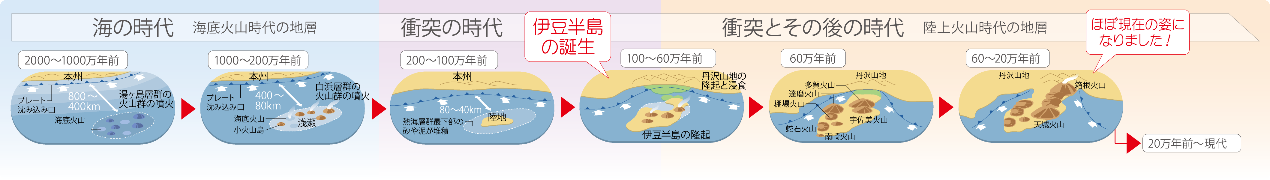
伊豆半島の歴史は地層などの証拠などによって約2000万年前までたどることができます。
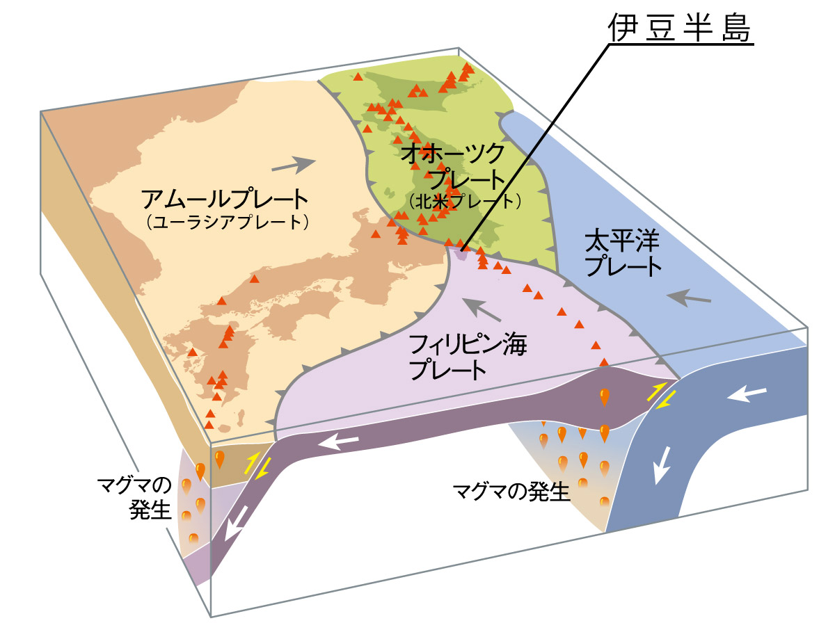
約2000万年前、伊豆は本州から数百km南、現在の硫黄島付近の緯度にありました。この頃の伊豆は深い海の底で活動する火山の集合体(海底火山群)でした。2011年3月の東日本大震災の原因となった「太平洋プレート」。この巨大なプレートは、伊豆半島が乗っている「フィリピン海プレート」の下にも沈み込んでいて、将来、伊豆半島になる大地の源、マグマを供給していました。
一方、フィリピン海プレートは、本州がのっている「ユーラシアプレート」の下に沈み込みます。フィリピン海プレートの上にできた海底火山や火山島はプレートとともに北に移動しました。100万年ほど前に本州に衝突。陸地同士が海を埋め、現在のような半島の形になりました。これが約60 万年前のできごとです。
半島となってから約20万年前までは、陸上のあちらこちらで噴火が起き、天城山や達磨山といった現在の伊豆の骨格を形づくる大型の火山ができました。
これらの大型火山の活動が終わると、日本には数少ない独立単成火山群の活動がはじまり、現在は「伊豆東部火山群」として活火山のひとつとなっています。また、プレートの動きは現在も伊豆の大地を本州に押し込み続けていて、地殻変動によりさまざまな地形を作っています。こうした二重三重の地質学的特異性が、多くの美しい景観や温泉を有する現在の伊豆半島を形成しています。伊豆半島は、世界のどこを探しても同種の例を見ない、地球上の特異点とも言える場所となっているのです。(青字付加:筆者)
2. プレートテクトニクス(プレート理論)
これまで、本コラムで何回か取り上げてきたものに、この「伊豆半島ジオパーク」の公式webサイトで述べられている、地球の「プレート」の動きがある。
大陸移動、地震、火山活動を解明する手がかりとなった、ドイツの気象学者「アルフレート・ヴェーゲナー」が提唱したこの理論が「プレートテクトニクス(プレート理論)」と呼ばれるものである。
現在の地球物理学の定説では、3億年前、地球上には、「パンゲア」と呼ばれる1つの大陸しか無かったが、2億年前にそれが分裂を始め、その後、多くの分裂によって、現在では10数枚となったプレート。その移動に応じて、上に乗った陸地も同じく移動している。
ハワイは、1年間に約8cmずつ日本に近づいていると言われている。このプレートが移動するという理論であり、「地震発生の有力な理論的裏付け」となっている。
プレートに乗った大陸どうしが衝突することもある。インドが、豪州沖から移動してきて、ユーラシアプレートに衝突、そのエネルギーで大地に皺が誕生、「ヒマラヤ山脈」ができた。
小規模な例であるが、「伊豆半島ジオパーク」の公式webサイトにあるように、「伊豆半島」も衝突によって合体したものである。
こう記していくと、「プレートは地球の表面を移動し続ける」と考えられるが、実はプレートにも「一生」がある。プレートの「原料」であるマグマは、長い海底火山(海嶺)から生み出され、凝固してプレートを構成する。そして、移動し、また深海の海溝深くに沈み込んでいって、消失するのである。
「伊豆半島の合体活動」は現在でも続いている、その延長線上にある巨大な活火山が富士山である。富士山のマグマ溜まりに影響を与えないはずはないであろう。
3.「世界遺産」(世界文化遺産)富士山
昨日、2026年6月26日午後10時半ごろ、下から突き上げられるような大きな揺れを感じた。気象庁の公式WEBサイトによると、「震央を山梨県東部・富士五湖とする、マグニチュード(M) 5.6、震源の深さ 20km 」の地震が起きたのである。
マグニチュードは先日の青森沖と比較するとかなり小さなものであったが、直下型であるため、震央の富士河口湖町では「震度6弱」と大きな揺れを与えた。
「火山噴火予知計画(文部省測地学審議会(現文部科学省科学技術・学術審議会)の建議」により、火山現象及び関係機関の研究、業務に関する成果、情報の交換について総合的判断を行うことを目的として、1974年に「火山噴火予知連絡会」が設置された。この連絡会の事務局は気象庁が担当、委員は学識経験者及び関係機関の専門家から構成されている。
翌、1975年「火山噴火予知連絡会」は、それまで休火山と見られていた富士山を活火山として選定した。つまり「何時噴火してもおかしくない日本の活火山111の一つ」に富士山は指定された。
富士山は、フィリピン海プレート、北米プレート、ユーラシアプレートが接する地域に位置して、標高は 3,776m で日本の最高峰であり最大の火山である。気象庁のホームページを見ると、富士山の噴火に関しては「781年から現在まで17回噴火と考えられる現象があった」と記されている。
なかでも大規模な噴火は二度起きている。一つが、864~866年に起きた「貞観噴火」である。溶岩が富士山周辺を広く覆い、「青木ヶ原溶岩」を形成、その後この溶岩の上に「青木ヶ原樹海」と呼ばれる広大な森林地帯が形成されたが、この大噴火は「平安時代の『東日本大震災』とも呼ばれる巨大地震」、貞観地震の5年前に起きた。
そして、もう一つが、日本最大級の地震「宝永地震」の49日後に始まり、江戸市中にまで大量の火山灰を降下させた、1707年に起きた「宝永噴火」である。
「富士山噴火と南海トラフ」(「講談社」ブルーバックス:京都大名誉教授鎌田浩毅(著))の「まえがき」に鎌田名誉教授は次のように記している。
「2011年に起きた東日本大震災によって、富士山をめぐる状況は一変した。東日本大震災は発生した日付の3月11日を取って『3.11』と呼ばれるが、その4日後に、富士山では震度6強の直下型地震が発生した。このとき、富士山の『マグマだまり』である重大な異変が起きた可能性があり、われわれ火山学者は全員肝を冷やした。まだ噴火が起きていないのは幸いと言うべきだが、もはや富士山はいつ噴火してもおかしくない『スタンバイ状態』に入ったと私は考えている。」
「そして何より、富士山の噴火はやがて起きる南海トラフ巨大地震と連動するおそれがある。歴史を振り返ってみると、江戸時代の宝永の大噴火は、それに先立って南海トラフでマグニチュード9クラス巨大地震(宝永地震と呼ばれる)が発生してからわずか49日後に起きている。」
「富士山噴火と巨大地震の連動にどう対応するかは、我が国にとって存亡をかけた喫緊の課題と言っても過言ではないのである」
南海トラフ巨大地震の強い揺れが加われば、富士山の直下にあるマグマだまりからマグマが勢いよく噴出して大噴火に至る、南海トラフ巨大地震と富士山の噴火には連動の恐れがあるということである。
今回のまとめ
「富士山噴火など起きない」という長い間の「常識」が、1975年富士山が「活火山」と定義された頃から大きく変わり、いまでは「いつか必ず噴火する」ということが「常識」となっている。
政府の「富士山噴火ハザードマップ」を受け、富士山が位置する静岡県、山梨県、また噴火によって吹き出す溶岩流の直接的な影響を受ける可能性のある神奈川県を含め、更には「降灰によって大きな影響を受ける」、東京都、千葉県、埼玉県、それらの各自治体でも「ハザードマップ」の見直しがなされた。
「南海トラフ大地震、首都圏直下大地震」のみならず「富士山の噴火」までも企業にとって喫緊の課題となってきたのである。「地震保険は高いから」と保険を購入することを躊躇する企業も多いと聞くが、いまや「地震・噴火・津波リスク」への対応は「待った無し」である。
「保険料が高いから・・・」と思っているのなら、「補償コストを低減させる方法」を実行すべきではないだろうか。
その最たる手段が「キャプティブの設立」である。その実行も一刻も早くすべきではないだろうか。「日本政府が、非常に高い確率で『南海トラフ巨大地震』、また『富士山の噴火』が起きる」と既に国民に周知しているから」である。
執筆・翻訳者:羽谷 信一郎
English Translation
Captive (CA) 85 – Mount Fuji, located at the tip of the Izu Peninsula
It has been a long time since the term ‘World Heritage’ began to be used in the same breath as ‘nature conservation’. In particular, it is well known that in June 2013, Mount Fuji—with its exceptionally beautiful appearance—was inscribed on the World Heritage List not merely as a ‘natural heritage site’ but as a ‘cultural heritage site’, owing to its cultural significance.
Based on the ‘World Heritage Convention’ adopted at the UNESCO General Conference in 1972, the top priority is ‘to protect and preserve sites in their current state’. Should a registered site lose its ‘outstanding universal value’, its listing is revoked; indeed, three sites had their listings revoked in 2007, 2009 and 2021.
In contrast to these ‘World Heritage Sites’, whose primary purpose is the preservation of nature in its original state, UNESCO also manages ‘Geoparks’, which aim to ‘utilise the sites for education and tourism whilst ensuring their protection, thereby contributing to regional revitalisation’.
Unlike ‘World Heritage Sites’, where access is often strictly restricted to ensure the rigorous protection and preservation of precious natural and cultural assets as treasures of all humanity, Geoparks aim to aim to ‘protect valuable landforms and geology (geo) that illustrate the Earth’s formation, whilst utilising them for education and tourism (geotourism) to revitalise the region’. They provide a space where visitors can enjoy not only nature itself, but also the ecosystems nurtured there, as well as the history, culture and industries of the people associated with the area, in a comprehensive manner.
The official website of the ‘Izu Peninsula Geopark’, operated by the ‘Beautiful Izu Creation Centre’ (a general incorporated association), contains the following explanation of Geoparks, which is quoted below.
What is a Geopark?
Like World Heritage Sites, Geoparks are part of a programme promoted by UNESCO (the United Nations Educational, Scientific and Cultural Organisation).
A Geopark is an area containing sites of international geological significance, managed under a concept that integrates ‘conservation’, ‘education’ and ‘sustainable development’. Geoparks promote sustainable regional development by utilising valuable geological heritage in fields such as environmental education and geotourism, whilst ensuring its protection.
Geoparks are also places where each participant can reflect on the connection between nature and our daily lives through enjoying and learning about the numerous sites within the area, and consider how best to safeguard that connection. To help visitors discover this connection between nature and people, Geoparks provide facilities such as visitor centres, information boards and geoguides.
1. The Formation of the Izu Peninsula
The official website of the ‘Izu Peninsula Geopark’ contains an interesting description of the formation of the Izu Peninsula, so I shall quote that section here.
Separation from the Continent – The Formation of the Japanese Archipelago –
To understand the unique origins of the Izu Peninsula, let us first look at how the Japanese archipelago was formed. The Japanese archipelago is shaped rather like a boomerang, isn’t it? The Kanto region is perhaps its centre. Why is the Japanese archipelago ‘curved’?
During the Cretaceous period, when dinosaurs still roamed the earth, Japan was attached to the eastern edge of the Eurasian continent. Around 25 million years ago, volcanic eruptions and other geological activity intensified due to plate subduction, causing the continental margin to begin fracturing. The sea flowed into these fissures, eventually forming the Sea of Japan, whilst the landmass separating from the continent gradually took shape as the Japanese archipelago. At this time, the landmasses moved as if pushing open a double door from the outside in: south-western Japan moved clockwise, whilst north-eastern Japan moved in the opposite direction. They more or less settled into their current positions around 14 million years ago.
In fact, at this stage, Izu had not yet become part of the Japanese archipelago. There was a sea between the two parts of Japan that had been pushed apart.
A Wanderer from the South – The Formation of the Izu Peninsula –
The history of the Izu Peninsula can be traced back approximately 20 million years through evidence such as geological strata.
Around 20 million years ago, Izu was located several hundred kilometres south of Honshu, at a latitude similar to that of present-day Iwo Jima. At that time, Izu was a cluster of volcanoes (a group of submarine volcanoes) active on the deep seabed. The ‘Pacific Plate’ was the cause of the Great East Japan Earthquake in March 2011. This enormous plate was also subducting beneath the ‘Philippine Sea Plate’—upon which the Izu Peninsula rests—supplying magma, the source of the land that would one day form the Izu Peninsula.
Meanwhile, the Philippine Sea Plate subducts beneath the ‘Eurasian Plate’, upon which Honshu rests. The undersea volcanoes and volcanic islands formed on top of the Philippine Sea Plate moved northwards along with the plate. Around one million years ago, it collided with Honshu. The landmasses filled in the sea, forming the peninsula shape we see today. This occurred approximately 600,000 years ago.
From the time it became a peninsula until around 200,000 years ago, eruptions occurred in various places on land, giving rise to large volcanoes such as Mount Amagi and Mount Daruma, which form the backbone of present-day Izu.
Once the activity of these large volcanoes ceased, activity began in one of Japan’s few isolated monogenetic volcanic groups, which is now recognised as one of the active volcanoes within the ‘Eastern Izu Volcanic Group’. Furthermore, plate movement continues to push the Izu landmass towards Honshu to this day, creating a variety of landforms through crustal deformation. These multiple layers of geological uniqueness have shaped the present-day Izu Peninsula, with its many beautiful landscapes and hot springs. The Izu Peninsula is a place that could be described as a singular point on Earth, with no comparable example to be found anywhere else in the world. (Blue text added by the author)
2. Plate Tectonics (Plate Theory)
A topic that has been covered several times in previous posts for this column is the movement of the Earth’s ‘plates’, as described on the official website of the ‘Izu Peninsula Geopark’.
This theory, the early foundations of which were proposed by the German meteorologist Alfred Wegener—and which provided the key to understanding continental drift, earthquakes and volcanic activity—is known as ‘plate tectonics (plate theory)’.
According to the current established theory in geophysics, 300 million years ago, there was only one continent on Earth, known as ‘Pangaea’; however, 200 million years ago, it began to break apart, and following numerous further splits, there are now more than ten plates. As these plates move, the landmasses resting upon them move as well.
It is said that Hawaii is moving closer to Japan at a rate of approximately 8 cm per year. This theory of plate movement provides ‘strong theoretical support for the occurrence of earthquakes’.
Continents riding on these plates sometimes collide with one another. India moved from off the coast of Australia and collided with the Eurasian Plate; the energy released by this collision caused the land to fold, resulting in the formation of the ‘Himalayan mountain range’.
Although a smaller-scale example, as stated on the official website of the ‘Izu Peninsula Geopark’, the Izu Peninsula itself was also formed by such a collision.
Writing it this way might lead one to think that ‘plates continue to move across the Earth’s surface’, but in fact, plates also have a ‘lifespan’. Magma, the ‘raw material’ of plates, is generated from long-extending undersea volcanoes (mid-ocean ridges) and solidifies to form the plates. It then moves, sinks deep into the deep-sea trenches, and eventually disappears.
The ‘collision activity of the Izu Peninsula’ continues to this day, and Mount Fuji is a massive active volcano situated along the extension of this process. It is inevitable that this will affect the magma chamber beneath Mount Fuji.
3. ‘ a World Heritage site’ (a World Cultural Heritage site) Mount Fuji
Yesterday, around 10.30 pm on 26 June 2026, I felt a strong tremor, as if something were thrusting up from below. According to the Japan Meteorological Agency’s official website, an earthquake with a ‘magnitude (M) of 5.6 and a focal depth of 20 km, with its epicentre in the Fuji Five Lakes area of eastern Yamanashi Prefecture’ had occurred.
Although the magnitude was considerably smaller than that of the recent earthquake off the coast of Aomori, as it was a shallow-focus earthquake, it caused significant shaking, reaching ‘Seismic Intensity 6-’ in Fujikawaguchiko Town, where the epicentre was located.
Pursuant to the ‘Volcanic Eruption Prediction Plan’ (a recommendation from the Geodetic Council of the Ministry of Education [now the Science and Technology and Academic Council of the Ministry of Education, Culture, Sports, Science and Technology]), the ‘Volcanic Eruption Prediction Liaison Committee’ was established in 1974 with the aim of making comprehensive judgements regarding volcanic phenomena and the exchange of information and research findings relating to the work of relevant organisations. The Japan Meteorological Agency serves as the secretariat for this committee, and its members consist of academics and experts from relevant organisations.
The following year, in 1975, the ‘Volcanic Eruption Prediction Liaison Committee’ designated Mount Fuji—which had previously been regarded as a dormant volcano—as an active volcano. In other words, Mount Fuji was designated as one of ‘111 active volcanoes in Japan that could erupt at any time’.
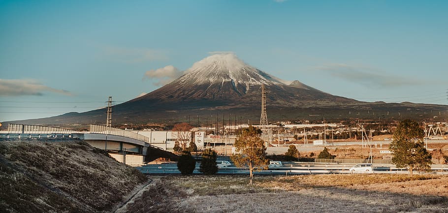
Mount Fuji is situated at the junction of the Philippine Sea Plate, the North American Plate and the Eurasian Plate. With an elevation of 3,776 metres, it is Japan’s highest peak and largest volcano. According to the Japan Meteorological Agency’s website, ‘there have been 17 phenomena considered to be eruptions of Mount Fuji from 781 to the present day’.
Among these, two large-scale eruptions have occurred. One of these was the ‘Jōgan Eruption’, which occurred between 864 and 866. Lava covered a vast area around Mount Fuji, forming the ‘Aokigahara Lava Field’; subsequently, a vast forest known as the ‘Aokigahara Sea of Trees’ developed on top of this lava. However, this major eruption took place five years before the Jōgan Earthquake—a massive earthquake also referred to as the ‘Great East Japan Earthquake of the Heian period’.
The other was the ‘Hōei Eruption’ of 1707, which began 49 days after the ‘Hōei Earthquake’—one of Japan’s largest earthquakes—and caused massive amounts of volcanic ash to fall even within the city of Edo.
In the ‘Preface’ to ‘Mount Fuji Eruptions and the Nankai Trough’ (Kodansha Bluebacks: authored by Hiroki Kamata, Professor Emeritus at Kyoto University), Professor Emeritus Kamata writes as follows.
‘The Great East Japan Earthquake of 2011 completely transformed the situation surrounding Mount Fuji. The Great East Japan Earthquake is commonly referred to as “3.11” after the date it occurred, 11 March; four days later, a direct-hit earthquake with a seismic intensity of 6+ struck beneath Mount Fuji. At that time, there was a possibility that a major disturbance had occurred in Mount Fuji’s “magma chamber”, and all of us volcanologists were left with our hearts in our mouths. Whilst it is fortunate that an eruption has not yet occurred, I believe that Mount Fuji has now entered a ‘standby state’ in which an eruption could occur at any time.”
‘Above all, an eruption of Mount Fuji could be linked to the massive Nankai Trough earthquake that is expected to occur eventually. Looking back at history, the great Hoei eruption of the Edo period took place just 49 days after a massive magnitude 9-class earthquake (known as the Hoei Earthquake) had occurred in the Nankai Trough.’
“It is no exaggeration to say that how we respond to the potential linkage between a Mount Fuji eruption and a massive earthquake is an urgent matter of life and death for our nation.”
If the intense shaking from a massive Nankai Trough earthquake were to occur, magma could be violently ejected from the magma chamber directly beneath Mount Fuji, leading to a major eruption; there is a risk of a link between a massive Nankai Trough earthquake and a Mount Fuji eruption.
Summary of this Issue
The long-held ‘common knowledge’ that ‘Mount Fuji will never erupt’ has changed significantly since 1975, when Mount Fuji was designated an ‘active volcano’; today, it is ‘common knowledge’ that ‘it will inevitably erupt at some point’.
Following the government’s ‘Mount Fuji Eruption Hazard Map’, local authorities in Shizuoka and Yamanashi Prefectures—where Mount Fuji is located—as well as Kanagawa Prefecture, which could be directly affected by lava flows from an eruption, and even Tokyo, Chiba and Saitama Prefectures, which would be ‘significantly affected by ash fall’, have all revised their own ‘hazard maps’.
Not only the ‘Nankai Trough Earthquake’ and the ‘Great Tokyo Metropolitan Area Earthquake’, but even a ‘Mount Fuji eruption’ has become an urgent issue for companies. I hear that many companies hesitate to take out insurance because ‘earthquake insurance is expensive’, but there is now absolutely no time to lose in addressing the risks posed by earthquakes, eruptions and tsunamis.
If you are thinking, ‘It’s because the premiums are high…’, shouldn’t you be implementing ‘measures to reduce compensation costs?
The most effective means of doing so is the ‘establishment of a captive’. Shouldn’t this be implemented as soon as possible? This is because ‘the Japanese government has already made it clear to the public that there is a very high probability of a “Nankai Trough mega-earthquake” and a “eruption of Mount Fuji” occurring’.
Author/translator: Shinichiro Hatani