
リスク対応策 2020.11.21
RM50 地名に潜むリスクへ備えるキャプティブ 1 (縄文海進)
目次
For those who prefer to read this column in English, the Japanese text is followed by a British English translation, so please scroll down to the bottom of the Japanese text.
中国(中華人民共和国)に天津という都市がある。中国が指定する、「国家中心都市」の一つである。大きな5つの河川が合流する場所に位置する、渤海に面した、中国北方地方最大の対外開放港を持つ港湾都市であり、2014年時点での天津都市圏の人口は1500万人を超える。この都市の名称「天津」は、読んで字のごとく、「天」と「津」の二つの漢字から成り立っている。
前者の「天」とは、「中国の皇帝は天(天帝)の子であり天命により天下を治める」という中国の古代の思想により、「皇帝」のことを意味している。1400年、後年、永楽帝と呼ばれる明の第3代皇帝「朱棣(しゅてい)」が皇位を争って挙兵、数々の戦いに勝利、皇位を簒奪すると、彼を意味する「天」の字が冠せられた「天津」の地名が歴史に登場した。天津の「津」とは、「船着場、渡船場、港」のことを言う。つまり、「天津」とは、「永楽帝が船に乗って河を渡った場所」の意味である。
1858年中国は第2次アヘン戦争で英仏連合軍に敗北、天津条約、北京条約が締結され、1860年天津は開港され、北京の外港として、英、米、仏、独、日、露、伊、ベルギー、オーストリア、ハンガリーが相次いで天津に租界を設置、中国で最も租界の数が多い都市となった。天津の観光スポットとして有名な「天津五大道」にある洋風の建造物や教会は、その時代の名残である。
この「船着場、渡船場、港」の意味である「津」を地名に持つ場所は、日本にも存在する、三重県津市である。伊勢平野の中心部に位置しているが、伊勢湾に面して大きく市街地を有する、三重県の県庁所在地である。滋賀県には、琵琶湖に面し、古代より琵琶湖の水上交通の要衝であった、山を挟んで向かい合う京都市との関係が深い「大津市」がある。飛鳥時代、667年飛鳥から近江に遷都した天智天皇はこの地で正式に即位、近江令や庚午年籍等、後の律令制の基礎となる施策を発布したが、天智天皇の崩御後、天皇の承継問題を巡って起きた672年の壬申の乱によって廃都となった。
いずれも「海、湖などの水に関連する場所」である。これらのように、「その街の機能」が「都市、町の名称」となっていることは多い。「現在の状況を示すもの」であればリスクになることはない。しかし、それが「現在の状況とは異なったと考えられる名称」であれば、「その名称の元になったこと」を検証して対応策を検討していかなければ、地震リスクに対しては無防備になるのである。とりわけ、地震の影響を大きく受ける可能性のある柔らかい土壌と考えられる地域であるか否かを確認することは重要である。
1.湊(みなと)
「港」以外に、「みなと」と呼ばれる漢字に「湊」がある、「水門」を意味する言葉である。古くは、港湾施設のうち、水上部分を「港」、陸上部分を「湊」と呼んだ。
この湊を冠する地名が、東京都中央区京橋地域にある。古くから、鐵砲洲稲荷神社の門前町として賑わいを見せている町であり、地域内に本湊町、船松町という町名があることから推察できるが、江戸に物資を運び込む舟運の要所であり「江戸湊」として栄えた街であった。
この「鐵砲洲稲荷神社」の「洲(す)」とは、「大辞泉」(小学館刊)によると、
「川・湖・海の底に土砂がたまって高くなり水面上に現れたもの」であり、「河口付近などの比較的浅い場所にできる」
とある。かつては「川であった」ということであり、昔の河川名にも「鉄砲洲川」があったが、1923年起きた関東大震災の瓦礫処理のため埋め立てられ、現在は鉄砲洲通となっている。
2.浦(うら)
現在の地名から以前の状態が容易に推測できるものであれば、「リスクが埋没していない」ため、様々な対応策を検討することができるが、現在の地名から「原風景」が推測できない場合は、「地震リスクの大きさ、影響度」に関して、その判断を誤る危険性がある。
「大辞泉」(小学館刊)によると、「浦(うら)」については、
「裏」と同語源で、外海に対して内側の意 1 海や湖が湾曲して陸地に入り込んだ所。入り江。2 海辺。浜。
とある。
NHKテレビ小説「エール」のなかで予科練が置かれた場所、またその愛唱歌「若鷲の歌」に歌われている場所として登場しているのが、琵琶湖に次いで日本で二番目に大きい茨城県南東部に広がる湖、「霞ヶ浦」である。江戸時代、茨城県が面する鹿島灘を「外の海」、霞ヶ浦を「内の海」と呼んだ。
このように海に面した地域に「浦」の文字が使われていれば「原風景」が推測でき、「台地に比べて地盤が軟らかい」と地震リスクに関して「リスクが顕在化している」ため、相応の対応策を取ることができるものであるが、「現在、全くそうは思えない地域」の場合、「リスクが潜在化している」ため、リスクが看過される危険性がある。
私の友人が居住している地が、埼玉県さいたま市、旧浦和市である。埼玉県は、海に面していない、関東平野の中央部に位置するさいたま市には、山や丘陵といえる場所は存在しておらず、全域にわたって標高が低く、最も低い地点で海抜1.1mであり、最も高い地点でも海抜は20.5mである。「昼間の人口流出が全国1位」と、ベッドタウンとしての性質が強い内陸県である。一番近い海である東京湾から30kmほど内陸部にあるこの地に「浦和」という地名がなぜ存在するのであろうか。
3.地球環境の変化
地球軌道の変化によると考えられているが、最終氷期を境にいくつか気温の変化はありながらも、地球の気温は継続的に上昇、氷が融け海洋に流出していった。北半球の中高緯度の多くが最も温暖な時期を迎えたのは、「ヒプシサーマル(hypsithermal)」、日本語では「完新世の気候最温暖期」と呼ばれる時期、現在から7,000年~5,000年前の時期であった。
完新世(Holocene)とは、昔高等学校の地学で習った沖積世(Alluvium)とほぼ同義であり、地質時代区分のうちで最も新しい時代、現代を含む地質年代のことである。本年1月「チバニアン」の名称が付けられたことで一般にも知られるようになった、日本地質学会のホームページに掲載されている、「国際地質科学連合(IUGS)の国際層序委員会(ICS)が発表した、以下の国際年代層序表の最新版(v 2020/01)」に詳述されている。
The latest version of the International Chronological Table (v 2020/01)
このヒプシサーマルの時期、氷河は北米やヨーロッパから姿を消し、グリーンランドと南極大陸に残るのみとなっていった。この氷河の融水の流出は、かつて氷河があった場所からはその重みが無くなり、一方海底には新たな重みが加わり、結果、陸上では隆起運動、海洋では沈降運動が起き始めて、その動きは現在でも続いている。この温暖化によって、地球各地では、湿潤化して森林が増加、草原の減少が起き、マンモスなど大型哺乳類を絶滅させることになったとされている。
現在のインドネシアやフィリピンなどがユーラシア大陸から分離して島となり、北米大陸もユーラシア大陸から分離、9600年前ころ、ドーバー海峡が出現、グレート・ブリテン島が大陸から切り離された時期である。
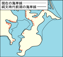
「農林水産省関東農政局のホームページ」によると、当時の関東地方の海岸線は下図のとおりであり、赤く記された貝塚の場所が当時の海岸線を証明していると言える。
According to the website of the Kanto Agricultural Administration Bureau, the Ministry of Agriculture, Forestry and Fisheries, the coastline of the Kanto region at that time was as shown in the figure below, and the locations of the shell mounds marked in red are evidence of the coastline at that time. The dotted line shows the “present-day shoreline” and the solid line shows the then”early jomon period coastline” .
4.縄文海進
「東京都葛飾区のホームページの『葛飾区史』」には次の記述がある。
12万年前は現在より海水面が高く、房総半島は島であった。この頃の内海を指して古東京湾と呼ぶ。旧石器時代は最終氷期にあたり、氷河が発達していたため海面が現在より著しく低く、浦賀水道付近以北は陸地となっており、「古東京川」と呼ばれる川が流れていた。
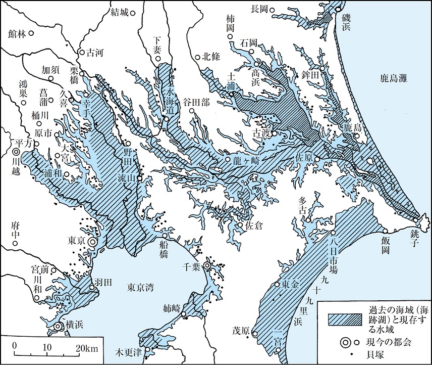
その後のヒプシサーマルの時期は、日本では「縄文時代」と言われている時期と重なり、日本列島のように、氷河から遠く離れた地域では海水面が大きく上昇、ピーク時である約6,000年まで上昇、海水面が5メートルほど高くなり、関東地方の貝塚の分析から「群馬県邑楽郡板倉町付近」や「埼玉県さいたま市」付近まで海が入り込んだことが裏付けられている。これは、「海が内陸部に進む」ことから「縄文海進」と呼ばれ、この頃の東京湾を指して「奥東京湾」と言われている。
「東京都葛飾区のホームページ」に掲載されている下図を見ると、当時、海が内陸部深くまで入り込んでいたことがよく解り、「浦和」は海に突き出した岬のようになっていて、まさに「浦(「1 海や湖が湾曲して陸地に入り込んだ所。入り江。2 海辺。浜。)」であったことが理解できる。
The diagram on the Katsushika Ward, Tokyo website shows that the sea had penetrated deep inland at that time, and “Urawa” is like a promontory jutting out into the sea and exactly what it sounds like: “Ura” (1) a place where the sea or a lake curved into the land, an inlet; (2) a beach, a cove.
(出典:「東京都葛飾区」ホームページ)
5.平安海進
前述の通り、地球軌道の変化によると考えられている「氷期と間氷期の繰り返し」では、氷河は発達したり溶けて縮小したりするため、海水量が変化、その結果海水面の変化が起こる。縄文時代の次に起きたのが、日本の平安時代であり、このときの海進は「平安海進」と呼ばれている。
上総国(現千葉県中部)の国司であった菅原孝標の娘、「更級日記」の執筆者として有名でありながら名前が判明していない菅原孝標女(すがわらのたかすえのむすめ)は、「更級日記」に、住まい周辺の景観も色々と書いているが、前述の「東京都葛飾区ホームページの『葛飾区史』」には次の記述がある。
「父が上総国司であった菅原孝標女は、『更級日記』の中に下総国府(現千葉県市川市)周辺の景観を書いている。これには、市川の真間にある長者という人の家は既に水中に没し、門柱が川の中から出ていたという。柴又河川敷などの発掘調査では、平安時代の遺構は地表の2〜3m下から発見された。」
「平安海進」の様子が良く読み取れる。「縄文海進」や「平安海進」ということから、「縄文時代」「平安時代」は、温暖な時代であったということが解る。つまり、それぞれの次の時代である、「弥生時代」、「鎌倉時代」は、寒冷な厳しい時代になったということを示している。弥生時代後期、邪馬台国を巡る「国造りの戦乱」、また鎌倉時代の数々の戦乱、この戦争の背景には、寒冷化したことによって「飢饉」や「疫病の蔓延」が起き「作物の収穫がおちたこと」があると推察される。
今回のまとめ
「地震は何時起きるか予測できない」と、いまの科学では結論づけられている。「座してその時を待つ」のか、それとも「できる手立てを打っていくのか」によって、当然、「その時」の対応も、また被害の大きさも変わってくるのは自明の理である。
地震は地盤によって大きく発生した場合の影響が異なる。「海から遠く離れているから地盤は大丈夫」と思っても、「古くは海の底にあった地盤の軟らかい場所」かもしれない。そのヒントの一つは地名にある、自社の事務所建物、工場、研究施設等がどのようなリスクを内在しているかを地名から解き明かしていくこともリスクマネジメントの一つではないだろうか。
その上で、本コラムの「RM 26ー防災科学技術研究所(NIED)」で紹介した、以下の「J-SHIS:地震ハザードステーション」を使用してそのリスクの規模、度合いを検証したうえで、地震リスクに対する備えが必要な地域と判断される場合には、本格的なリスクマネジメントをおこない、キャプティブの設立によって十分な補償内容、十分な補償額を海外の再保険会社のサポートから得る仕組みづくりをしてみてはいかがであろうか。
執筆・翻訳者:羽谷 信一郎
English Translation
Risk Management (RM) 50 – Captives prepared for “Risk in place names” 1 (Jomon Transgression)
There is a city in China called Tianjin, which is one of the “national central cities” designated by China, located at the confluence of five major rivers and facing the Bohai Sea. Tianjin is a port city with the largest open port in northern China with a population of more than 15 million in the Tianjin metropolitan area as of 2014. The city’s name “Tianjin” (Ten-shin: The Japanese reading of the word) consists of two Chinese characters: “Tian (Ten:The Japanese reading of the word)” and “Jin (Shin:The Japanese reading of the word).”
In 1400, when Emperor Cheng Di, the third Ming dynasty emperor, Zhu Di, who was known as the “Emperor of Yongle,” raised his troops to fight for the imperial throne and won a series of battles and usurped the throne, the city was named after him. The name of the place “Tianjin,” bearing the character for “Tian”(Ten:The Japanese reading of the word) meaning Heaven(him), appeared in history. The word “Jin (Tsu: The Japanese reading of the word) in Tianjin means “landing place, ferry port, or harbor”. In other words, “Tianjin” means “the place where the Emperor Yongle crossed the river in a boat”.
In 1858, China was defeated by the British and French allied forces in the Second Opium War, and the Treaty of Tianjin and the Treaty of Peking were signed. In 1860 Tianjin was opened to the public, and as an outer port of Beijing, Britain, the United States, France, Germany, Japan, Russia, Italy, Belgium, Austria, and Hungary successively established concessions in Tianjin, making it the city with the largest number of concessions in China.The Western-style buildings and churches on the famous Tianjin Five Avenues, a tourist attraction in Tianjin, are remnants of this era.
“Tsu”, meaning “landing place, ferry port, or harbor,” is also found in Japan, in the city of Tsu, Mie Prefecture. It is located in the center of the Ise Plain, but has a large urban area facing Ise Bay and is the capital of Mie Prefecture. O-tsu City, facing Lake Biwa, has been an important water transportation hub on Lake Biwa since ancient times, and is closely related to Kyoto City across the mountains. In 667, Emperor Tenchi moved the capital from Asuka to Omi, where he formally ascended the throne, and promulgated measures such as the Omi Decree and the Kogo Registry, which would later become the basis for the Ritsuryo system.However, after the fall of Emperor Tenchi, the city was abandoned in 672 due to the Jinshin War, a dispute over the succession of the Emperor.
In both cases, the city was “associated with the sea, lakes, and other bodies of water”. In many cases, as in these cases, “the function of the city” is “the name of the city or town”. It is not a risk if it is “indicative of the present situation”. However, if it is a name that is considered to be different from the current situation, the city or town will be unprotected against earthquake risk unless the original name is verified and countermeasures are considered. In particular, it is important to confirm whether or not the area is considered to have soft soil that could be greatly affected by an earthquake.
1. Minato (Port)
In addition to “port,” the Chinese character for “port” has the word “(another)Minato” in it, meaning “water gate”. In ancient times, the water part of the port facilities was called “Minato” and the land part was called “(another) Minato”.
The name of the place named after this “(another )Minato” is located in the Kyobashi area, Chuo-ku, Tokyo. It has long been a bustling town in front of the Teppozu Inari Shrine, and as can be inferred from the names of the towns of Honminato-cho and Funamatsu-cho, it was a key location for transporting goods to Edo, and prospered as the “Edo Harbor”.
The word “zu(su)” in Teppozu Inari Shrine is, according to “Dai-jisen” (published by Shogakukan,Inc.):
The accumulation of sediment on the bottom of a river, lake or ocean that has risen to the surface of the water” and “forms in relatively shallow areas such as near river mouths.
It used to be a river, and the old name of the river was Teppozu River, but it was reclaimed to clear away the debris from the Great Kanto Earthquake of 1923, and is now Teppozu Street.
2 Ura
If the previous conditions can be easily inferred from the current place names, then the “risk is not buried” and various response measures can be considered, but if the “original landscape” cannot be inferred from the current place names, then there is a risk of misjudgment regarding the “magnitude and impact of the earthquake risk”.
According to the “Dai-jisen” published by Shogakukan inc., the name “Ura” is:
Etymology of the same word as “back,” meaning inward in relation to the open sea.
1 A place where a sea or lake curves and enters land; an inlet.
2 A beach.
Kasumiga-ura, which is the second largest lake in Japan after Lake Biwa, is the location of the Naval Aviator Prepratory School in the NHK TV novel Yale, and is also mentioned in the song “Wakawashi no Uta” (The Song of the Young Eagle), in southeast Ibaraki Prefecture. During the Edo period, the Kashima Sea and Kasumiga-ura were called “the outer sea” and “the inner sea”, respectively.
If the word “Ura” were used in this way in an area facing the sea, we would be able to imagine the original landscape and take appropriate measures because the ground is softer than the plateau and the risk of earthquakes has become apparent, but in the case of an area that doesn’t seem to be like that at present, the risk is latent and may be overlooked.
A friend of mine lives in Saitama City, Saitama Prefecture, formerly known as Ura-wa City. There are no mountains or hills in Saitama City, which is located in the middle of the Kanto Plain and does not face the sea. The highest point is 20.5 m above sea level. The outflow of population during the daytime is the highest in the country. Why does the name “Ura”-wa exist here, 30 km inland from Tokyo Bay, the nearest ocean?
3. Global environmental changes
While there were some temperature changes after the last glacial period, thought to be due to changes in Earth’s orbit, global temperatures continued to rise and ice melted and spilled into the oceans. Much of the middle and high latitudes of the northern hemisphere experienced its warmest period during what is known as the “hypsithermal” or “Holocene climatic maximum warming period” in Japanese, 7,000 to 5,000 years ago.
Holocene is almost synonymous with Alluvium, the most recent geological age of the Holocene period, which includes the modern era. The latest version of the International Commission on Stratigraphy (ICS) of the International Union of Geological Sciences (IUGS) published the following international chronostratigraphic tables (v 2020/01) on the Geological Society of Japan’s website, which became known to the public through the naming of the “Tibanian”(after Chiba Prefecture in Kanto-area, Japan) in January of this year.
During this period of hypsithermal activity, glaciers disappeared from North America and Europe, leaving only Greenland and Antarctica. This glacial meltwater runoff removed its weight from the places where the glaciers once stood, while new weight was added to the seafloor, resulting in uplift movements on land and subduction movements beginning to occur in the oceans, a movement that continues to this day. This global warming is believed to have caused an increase in forests and a decrease in grasslands in many parts of the world due to wetting, leading to the extinction of mammoths and other large mammals.
This is when Indonesia and the Philippines separated from the Eurasian continent to form islands, the North American continent separated from the Eurasian continent, and the Strait of Dover appeared around 9,600 years ago, separating the island of Great Britain from the Eurasian continent.
4. Jomon transgression
The “Katsushika Ward History” section of the Tokyo Metropolitan Katsushika Ward website states the following.
120,000 years ago, the sea level was higher than today, and the Boso Peninsula was an island. At that time, the inland sea was called Paleo-Tokyo Bay. During the Paleolithic period, the sea level was significantly lower than today due to the development of glaciers, and the area north of the Uraga Channel was land. A river called the “Old Tokyo River” ran through it.
The subsequent hypsithermal period coincided with what is known in Japan as the Jomon Period, and in areas far from glaciers, such as the Japanese Islands, sea levels rose significantly, reaching a peak of about 6,000 years, when sea levels rose to about 5 meters. It has been proven that the sea penetrated to the vicinity of Saitama City and Saitama Prefecture. This is called the “Jomon Kaishin( transgression),” because the sea was moving inland, and Tokyo Bay at this time is called “Oku(Back)-Tokyo Bay”.
5. Heian Kaishin (transgression)
As mentioned above, during the recurrence of glacial and interglacial periods, which are thought to be caused by changes in the Earth’s orbit, glaciers develop or melt and shrink, causing changes in the amount of sea water, which in turn causes changes in sea level. The next event after the Jomon period was the Heian period in Japan, which is known as the Heian Kaishin (transgression).
“Sugawara no Takasue no Musume (daughter)”, the daughter of Takasue Sugawara, who was a provincial governor of Joso Province (present-day central part of Chiba Prefecture), and who is famous as the author of “Sarashina Nikki” (Sarashina Diary), but whose name has not yet been found, wrote in “Sarashina Nikki” about the scenery around her house.In the aforementioned “History of Katsushika Ward” on the Tokyo Metropolitan Katsushika Ward website, there is a description as follows
“Sugawara Takasue no Musume(daughter)”, whose father was a provincial governor of Joso Province, wrote in her “Sarashina Nikki” about the scenery around Shimosa Kokufu (now Ichikawa City, Chiba Prefecture). According to this diary, the house of a man named Choja, located in the middle of Ichikawa, had already been submerged in the water and its gateposts were sticking out of the river. In excavations along the Shibamata River and other areas, the remains of the Heian period have been found two to three meters below the surface of the ground.
The condition of the Heian Kaishin (transgression) can be clearly read. The Jomon and Heian periods are known as the “Jomon Kaishin” and “Heian Kaishin” periods, which indicate that the Jomon and Heian periods were a warm period. The next two periods, the Yayoi and Kamakura periods, were cold and severe. In the late Yayoi period, the “war of state building” over Yamatai-koku, and the numerous wars of the Kamakura period, the background to these wars is presumably due to the fact that the cold weather caused famines and epidemics to spread, and crops failed to be harvested.
Summary of this issue
Today’s science has concluded that we cannot predict when earthquakes will strike. It is obvious that the response and the size of the damage will vary depending on whether we sit and wait for the right moment or take the necessary measures.
The impact of an earthquake varies depending on the ground. Even if you think that the ground is safe because it is far from the sea, it may be a soft place that used to be at the bottom of the sea. One of the hints for this is in the name of the place where the company’s office, plant or research facility is located, and one of the ways to manage this risk is to find out what kind of risks are inherent in the name of the place.
In addition, I recommend that the scale and degree of risk be verified using the J-SHIS: Earthquake Hazard Station (J-SHIS) introduced in “RM 26 – National Institute for Earth Science and Disaster Prevention (NIED)” in this column. If an area is identified as requiring earthquake risk preparedness, it is recommended that full-scale risk management be undertaken and that a system be put in place to ensure that sufficient coverage, and an adequate amount of coverage, is available through the establishment of a captive with the support of an overseas reinsurance company.
Author/translator: Shinichiro Hatani