
キャプティブ 2022.04.30
CA36「南海トラフ巨大地震」に備えるキャプティブ
目次
For those who prefer to read this column in English, the Japanese text is followed by a British English translation, so please scroll down to the bottom of the Japanese text.
キャプティブという最先端のリスクマネジメント・ツールがその威力を遺憾なく発揮するのは、「リスクの発生頻度は低いが、一旦発生すると非常に大きな損害をもたらすリスク」に対応するツールとして設立される場合であり、その筆頭にあげられるリスクが「地震リスク」である。
気象庁のホームページでは、「南海トラフ地震」については、次の通り記されている。
「南海トラフ地震は、駿河湾から日向灘沖にかけてのプレート境界を震源域として概ね100~150年間隔で繰り返し発生してきた大規模地震です。前回の南海トラフ地震(昭和東南海地震(1944年)及び昭和南海地震(1946年))が発生してから70年以上が経過した現在では、次の南海トラフ地震発生の切迫性が高まってきています」
「南海トラフ地震」は、下図「過去に発生した南海トラフ地震の震源域の時空間分布」(出典:「気象庁ホームページ」・「南海トラフの地震活動の長期評価(第二版)」(地震調査研究推進本部))にあるとおり、記録の乏しかった中世以前では200年、その後は100~150年の間隔で発生してきた。
また、東海地震、東南海地震、南海地震が数時間から数年の期間をおいてあるいは時間を置かずに同時に3つの地震が連動していること(3連動地震)が多かったことが併せて解る。
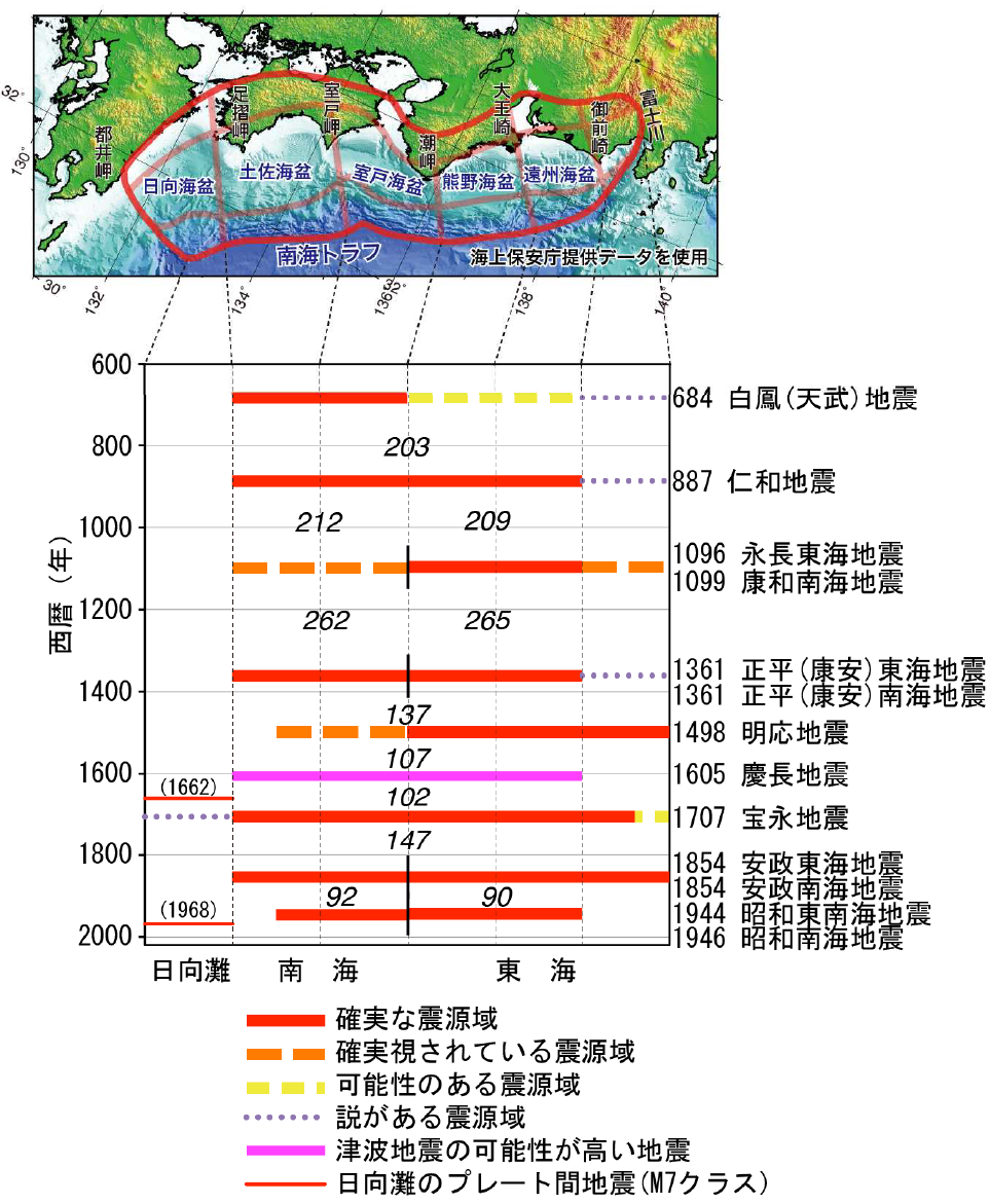
過去に発生した南海トラフ地震の震源域の時空間分布
(出典:「気象庁ホームページ」・「南海トラフの地震活動の長期評価(第二版)」(地震調査研究推進本部))
1.未知の南海トラフ地震の痕跡発見
近い将来の発生が懸念される南海トラフ地震の想定震源域の東側で、「7世紀末に未知の南海トラフ地震が発生していた痕跡」を産業技術総合研究所(産総研)などの研究チームが発見、想定震源域の西側では684年に南海地震の「白鳳(はくほう)地震」が起き、東西で連動した巨大地震だった可能性があるとの報道が、2019年11月メディアを駆け巡った。
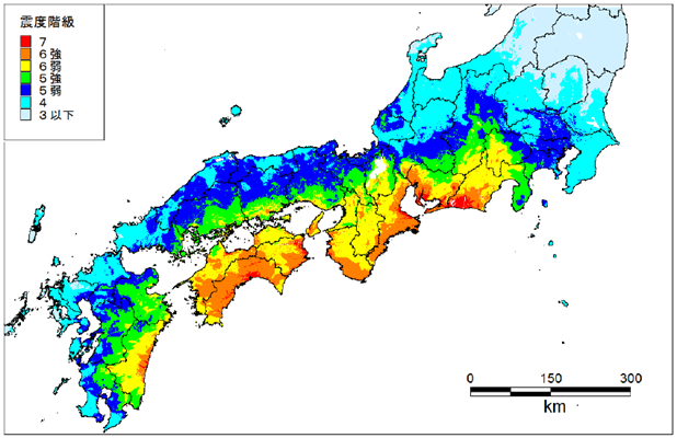
1944(昭和19)年12月7日に発生、東海地方に大きな被害をもたらした「昭和東南海地震」。しかし、戦時中のため報道されることはなかった。以前から「震度7相当の地域がある」と推定はされていたが、2019年末、この地震による各地の震度分布を名古屋大のチームが再評価した結果が、「愛知県の西尾市、静岡県の菊川市と袋井市の3カ所が『震度7』であり、揺れが大きかった地域は(今後の大地震への)注意が必要だ」として報道された。
南海トラフ地震の想定震源域は、3つに分かれている。静岡地方を想定震源域とする地震が「東海地震」であり、愛知、三重、和歌山を想定する地震が「東南海地震」、その以西宮崎沖まで伸びる想定震源域を持つ地震が「南海地震」である。時間差があっても、前述のとおり、これら3つの震源域が連動する可能性が高いと言われており、「東日本大震災を遙かに凌ぐ、超巨大震災になる」と予測されている。
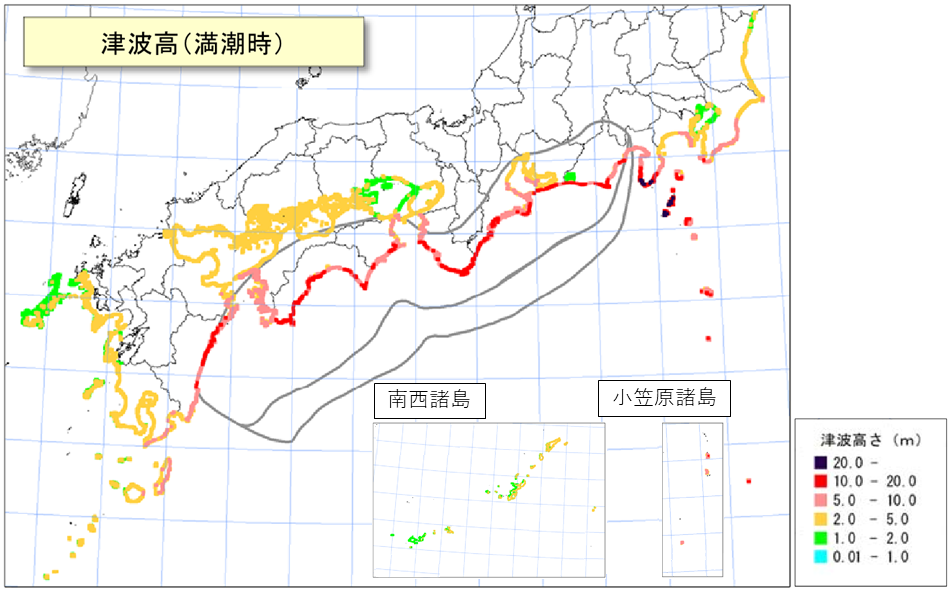
気象庁のホームページの「南海トラフ地震について」に、その詳細が記されている。以前、内閣府は「南海トラフ巨大地震の被害想定」について、揺れが最大になる場合には、震度6強以上のエリアが太平洋岸に広範に広がり、「死者は32万人を超え、経済被害も220兆円を超える」との想定をしていた。しかし、2019年5月、このうち死者の想定数を23万人強に引き下げた、理由としては「東日本大震災の後に住民の津波避難の意識が向上したことが影響した」と述べたが、「今後の調査結果によっては再び想定が増えることもある」とも付言している。
従来の地震の被害想定では、「揺れによる物的損害」が最も重視されていたが、東日本大震災の津波被害の巨大さから、南海トラフ巨大地震対策として種々の「津波対策」の手が打たれている。ただ、これらは、あくまでも「人命救助によって、被害者の数を減らすことが最優先された対策」であり、経済対策の点では保険を含めて、十分な対応がなされているとは言い難い状況である。
(出典:「気象庁ホームページ」)
海洋プレートは、大陸プレートよりも強固で密度が高いため、2つのプレートが衝突すると海洋プレートは大陸プレートの下に沈んでいく。太平洋プレートが北米プレートの下に沈み込んでいく際に発生した地震が「東日本大震災」であり、フィリピン海プレートがユーラシアプレートの下に沈み込んでいる接地面は「南海トラフ」と呼ばれ、その沈み込みの際に発生する現象が、「南海トラフ巨大地震」である。
「温故知新」とは言い古された言葉であるが、「満足な予知ができない事象」に対してはこれほど重要な言葉はないであろう。古来起きた事象を知り、今後起こる可能性のあることを予測してその事態に備える。この言葉こそ「地震リスクマネジメント」の本質そのものを示している。過去にどんな地震があり、どんな損害が発生したか、これを識ることは重要な「将来への備え」になる。
この意味で、古文書に限らず、「津波の被害を記した石碑である『地震碑』」、更には古老の言い伝えでさえ、「ビッグデータ化」していくべきではないかと考えている。そのためには、「科学的なデータ観測」のみならず、「歴史学」の知見を大いに活用していくべきと筆者は考えるものであるが、幸いなことにその学問分野が拡がりを見せている。
「地震考古学」という新しい概念を提唱した、地震考古学者寒川旭(さんがわ あきら)氏による、この講演にその姿を見ることができる。⇒●「産総研サイエンスカフェ in 関西「21世紀の巨大地震を考える -歴史から探る関西の地震-」(産総研公式YouTube)
2.地震の大きさ
マグニチュードが1つ大きくなると地震のエネルギーは約30倍になる。マグニチュードが2つ違うと地震のエネルギーは約1000倍(≒30×30倍)になることはあまり知られていない。マグニチュード0.1の差はエネルギーでは約1.4倍の差、マグニチュード0.2の差では約2倍(101.5×0.2 = 100.3 ≒ 1.995)となる。
「南海トラフ巨大地震」の規模は、マグニチュード9.0の東日本大震災を超える超巨大地震、マグニチュード9.1が想定されている。つまり「南海トラフ巨大地震」の地震エネルギー量は、未曾有の被害をもたらした「東日本大震災」の約1.4倍のエネルギー量になるということである。如何に巨大な地震であるかが解る。
今回のまとめ
損害保険の世界では、「事故などで対象物が物理的影響を被ること」を「損害」といい、「損害を被った結果、その対象と一定の関係がある人に与える経済的影響のこと」を「損失」という。
地震によって損失を被る「不確定な可能性」を保険料というコストとして「確定させる仕組み」である「地震保険」を活用することによって「企業経営の不確実性」を減じていくことは、重要な経営戦略である。
しかし、「地震保険」を利用したとしても、単なる地震による建物等の損壊というリスクだけではなく、南海トラフ巨大地震では、「大規模な地殻変動が起き未曾有の被害が起きる可能性もある」ので、地震保険の補償内容も十分吟味検討する必要がある。
また、日本の損害保険会社で引受けられる地震リスクの総量(引受キャパシティ)にも限界がある。政府が地震保険を最終的に引受ける、「個人の住宅・家財に関わる地震保険」でも、その総量は約11兆円と南海トラフ巨大地震で予想される損害額220兆円の20分の1、僅か5%にしか過ぎない規模である。
だからこそ、海外の地震保険の引受キャパシティを日本に持ってこれるツールであるキャプティブの効用は高いのである。また、東日本大震災のとき飛び交った「想定外」という言葉を地震後の役員会で発しないためにも、この「キャプティブ」という仕組みを上手く活用して、「地震保険を補償金額、補償内容、補償範囲の面から充実させること」が、今後30年以内に70~80%の確率で起きると政府が言明している「南海トラフ巨大地震」への対応としては、非常に重要な経営戦略になるのではないだろうか。
執筆・翻訳者:羽谷 信一郎
English Translation
Captive (CA) 36 – Captives prepared for Massive Nankai Trough Earthquake
Captives, state-of-the-art risk management tools, are most effective when they are established as a risk management tool to deal with ”risks that occur infrequently but, once they do occur, can be extremely damaging”. The first such risk is ”earthquake risk”.
The Japan Meteorological Agency’s website page on the Nankai Trough Earthquake states the following:
The Nankai Trough Earthquakes are large earthquakes that have occurred repeatedly at intervals of 100 to 150 years, with their epicenters located at the plate boundaries between Suruga Bay and the offshore Hyuga-nada. More than 70 years have passed since the last Nankai Trough earthquakes (“Showa Tonankai Earthquake (1944)” and “Showa Nankai Earthquake (1946)”), and the imminence of the next Nankai Trough earthquake is increasing.
As shown in the figure below, “Spatial and temporal distribution of the epicenters of past Nankai Trough earthquakes” (Source: JMA website, “Long-term assessment of seismic activity in the Nankai Trough (second edition)” (Earthquake Research Promotion Headquarters)), Nankai Trough earthquakes occurred every 200 years before the Middle Ages, when records were scarce, and every 100 to 150 years afterwards. It can also be seen that the Tokai, Tonankai, and Nankai earthquakes were often linked at the same time (triple-linked earthquakes), within a few hours or years of each other.
Spatial and temporal distribution of the epicentral regions of the past Nankai Trough earthquakes
(Source: Japan Meteorological Agency (JMA) website, “Long-term Evaluation of Seismic Activity in the Nankai Trough (Second Edition)” (Headquarters for Earthquake Research Promotion))
1. Discovery of traces of the unknown Nankai Trough earthquake
In November 2019, a research team from the National Institute of Advanced Industrial Science and Technology (AIST) and others discovered “traces of an unknown Nankai Trough earthquake that occurred at the end of the 7th century” on the eastern side of the epicenter of the Nankai Trough earthquake that is feared to occur in the near future. In the west of the hypothetical epicentre area, the Hakuho Earthquake, a Nankai quake, occurred in 684, and the media reported that it may have been a huge earthquake linked to the east and west.
The “Showa Tonankai Earthquake” occurred on December 7, 1944, and caused great damage in the Tokai region. However, because it was during wartime, it was never reported.It has long been estimated that there were areas with an intensity of 7 on the Japanese seismic scale, but at the end of 2019, a team from Nagoya University re-evaluated the distribution of seismic intensity in various areas caused by the earthquake. It was reported that “three places – Nishio City in Aichi Prefecture, Kikukawa City and Fukuroi City in Shizuoka Prefecture – had an intensity of 7 on the Japanese seismic scale, and that those areas with the strongest tremors should be warned (of future major earthquakes)”.
The Nankai Trough is divided into three epicenters: the Tokai earthquake, with its epicenter in the Shizuoka region; the Tonankai earthquake, with its epicenter in Aichi, Mie and Wakayama; and the Nankai earthquake, with its epicenter extending west to the coast of Miyazaki. Even if there is a time lag, as mentioned above, it is said that there is a high possibility that these three epicenters will interlock, and it is predicted that “it will be a super earthquake far greater than the Great East Japan Earthquake”.
The Japan Meteorological Agency (JMA) has more details about the Nankai Trough Earthquake on its website. In the past, the Cabinet Office had predicted that if the tremors were to reach their maximum, areas of intensity 6 or higher would spread widely along the Pacific coast, killing more than 320,000 people and causing economic damage of more than 220 trillion yen. However, in May 2019, it lowered its estimate of the number of fatalities to just over 230,000, saying that this was due to “improved awareness of tsunami evacuation among residents after the Great East Japan Earthquake”, but adding that “the estimate may be increased again depending on the results of future surveys”.
Conventional earthquake damage estimates have focused on “property damage caused by shaking”, but the enormity of the tsunami damage caused by the Great East Japan Earthquake has led to various “tsunami countermeasures” being put in place to deal with Nankai Trough earthquakes. However, these are only “measures that prioritise saving lives and reducing the number of victims”, and it is difficult to say that sufficient countermeasures, including insurance, have been taken in terms of economic measures.

(Source: Japan Meteorological Agency (JMA) website) (Source: Japan Meteorological Agency (JMA) website)
The oceanic plate is stronger and denser than the continental plate, so when the two plates collide, the oceanic plate sinks beneath the continental plate.The Great East Japan Earthquake occurred when the Pacific Plate sank beneath the North American Plate, and the Philippine Sea Plate is sinking beneath the Eurasian Plate, and the ground surface is called the Nankai Trough, which is a phenomenon that occurs when the plate sinks. This is the Nankai Trough major earthquake that is strongly feared to occur.
The phrase “learning from the past” is an old one, but it is probably the most important one when it comes to events that cannot be predicted satisfactorily. We need to know what has happened in the past, predict what may happen in the future and prepare for it. This is the essence of “earthquake risk management”. Knowing what kind of earthquakes have occurred in the past and what kind of damage they have caused is an important way of “preparing for the future”.
In this sense, not only old documents but also “earthquake monuments”, which are stone monuments describing the damage caused by tsunamis, and even the legends of old people, should be converted into “big data”. In order to do this, I believe that we should not only make use of “scientific data observation” but also “historical studies”. Fortunately, the field is expanding, as can be seen in this lecture by earthquake archaeologist Akira Sangawa, who proposed the new concept of “earthquake archaeology”. ⇒●”AIST Science Cafe in Kansai “Thinking about Giant Earthquakes in the 21st Century -Earthquakes in Kansai Explored from History-” (AIST official YouTube)
2. Magnitude of the earthquake
When the magnitude increases by one, the energy of the earthquake increases by about 30 times. It is not widely known that the energy of an earthquake is about 1,000 times greater (≈30 x 30 times greater) when the magnitude differs by two. A difference of 0.1 magnitude is about 1.4 times the difference in energy, and a difference of 0.2 magnitude is about twice the difference (101.5 x 0.2 = 100.3 ≈ 1.995).
The scale of the “Nankai Trough Mega Earthquake” is estimated to be 9.1 on the Richter scale, which is much larger than the Great East Japan Earthquake of 9.0 on the Richter scale. In other words, the amount of seismic energy from the “Nankai Trough Mega Earthquake” would be about 1.4 times the amount of energy from the Great East Japan Earthquake, which caused unprecedented damage. This shows just how huge this earthquake is.
Summary of this issue
In the world of non-life insurance, the term “damage” refers to “the physical impact of an accident on an object”, and “loss” refers to “the economic impact of the damage on people who have a certain relationship with the object”. It is an important management strategy to reduce the “uncertainty of corporate management” by using “earthquake insurance”, which is a mechanism to fix the “uncertain possibility” of loss due to an earthquake as a cost in the form of insurance premiums.
However, even if you use earthquake insurance, it is not just the risk of damage to buildings caused by earthquakes, but also the possibility of unprecedented damage caused by large-scale crustal movement in the event of a huge Nankai Trough earthquake.
There is also a limit to the total amount of earthquake risk (underwriting capacity) that can be underwritten by Japanese non-life insurance companies. Even in the case of earthquake insurance for individual houses and household goods, which is ultimately underwritten by the Government of Japan, the total amount is approximately 11 trillion yen, which is only one twentieth, or 5%, of the 220 trillion yen in losses expected in a major Nankai Trough earthquake.
This is why captives are highly effective as a tool to bring the underwriting capacity of overseas earthquake insurance to Japan. In addition, in order to avoid the word “unexpected”, which was used in the aftermath of the Great East Japan Earthquake, to be uttered in the boardroom after the quake, it would be a very important management strategy to make good use of the captive system and to improve the amount, content and coverage of earthquake insurance in order to cope with the Nankai Trough Earthquake, which the government has stated has a 70-80% probability of occurring within the next 30 years.
Author/translator: Shinichiro Hatani