
リスク対応策 2022.05.15
RM72「地名に潜むリスク」へ備えるキャプティブ 6(「中央構造線」徳島)
目次
For those who prefer to read this column in English, the Japanese text is followed by a British English translation, so please scroll down to the bottom of the Japanese text.
グローバル・リンクが設立をサポートするキャプティブは、日本の元受保険会社から再保険を引受ける「再保険会社」として機能することになるが、更に「再々保険」の形でその大半のリスクを最終的に引受けるのは、ロンドンの「ロイズ」(Lloyd’s of London) のシンジケートや世界最大級の再保険会社である。そのうちの一社、世界最大の再保険会社はドイツに本社を有する。
彼らとの打ち合わせや協議で同本社をたびたび訪れた。時期が秋頃であれば、その街で開かれる「世界最大級のお祭り」にも折良く参加できる。残念ながら、2020年、2021年は「新型コロナ禍」のため中止となった、9月中旬から10月初旬に掛けて開かれる世界最大のビール祭り、「オクトーバー・フェスト」である。
参加する多くのドイツ人は男性も女性も「ドイツ風というより、地勢的に近いスイス風の民族衣装」で着飾っていた。全世界から600万人を超える人々が、「歌い、踊り、語らい、ビールを飲む」ために参加する、その「祭り」が開かれる場所はドイツ南部の中核都市、ミュンヘンである。
明治時代初期、そのミュンヘンから、いわゆる「お雇い外国人」として招かれ東京帝国大学(現・東京大学)の地質学採鉱学科の初代教授となった、ハインリッヒ・エドムント・ナウマン。理科の教科書に、「古代、日本に生息していたゾウの化石を発見した人物」として、また「そのゾウは彼の名前から『ナウマンゾウ』と名付けられた」と載っている人物である。
これまで本コラムで度々紹介してきた「国立研究開発法人産業技術総合研究所(産総研)地質調査総合センター」、同センターのホームページには、「ナウマンゾウの名前の元となったナウマン博士 (ドイツ) は、130年前に来日し、 日本の地質学の基礎を築くのに大きな貢献をしました。」と記されている。
また、「産総研(産業技術総合研究所)の歩みは、1882年(明治15年)に国立の地質調査機関である地質調査所が設立されたことをもって始まります。この地質調査所の設立には、ドイツから来日した地質学者ナウマンが深くかかわっています。」とも記されている。ナウマンは「ゾウの名前に名を残す」だけではなく、今に至る日本の地質学の発展に大いに寄与した人物なのである。
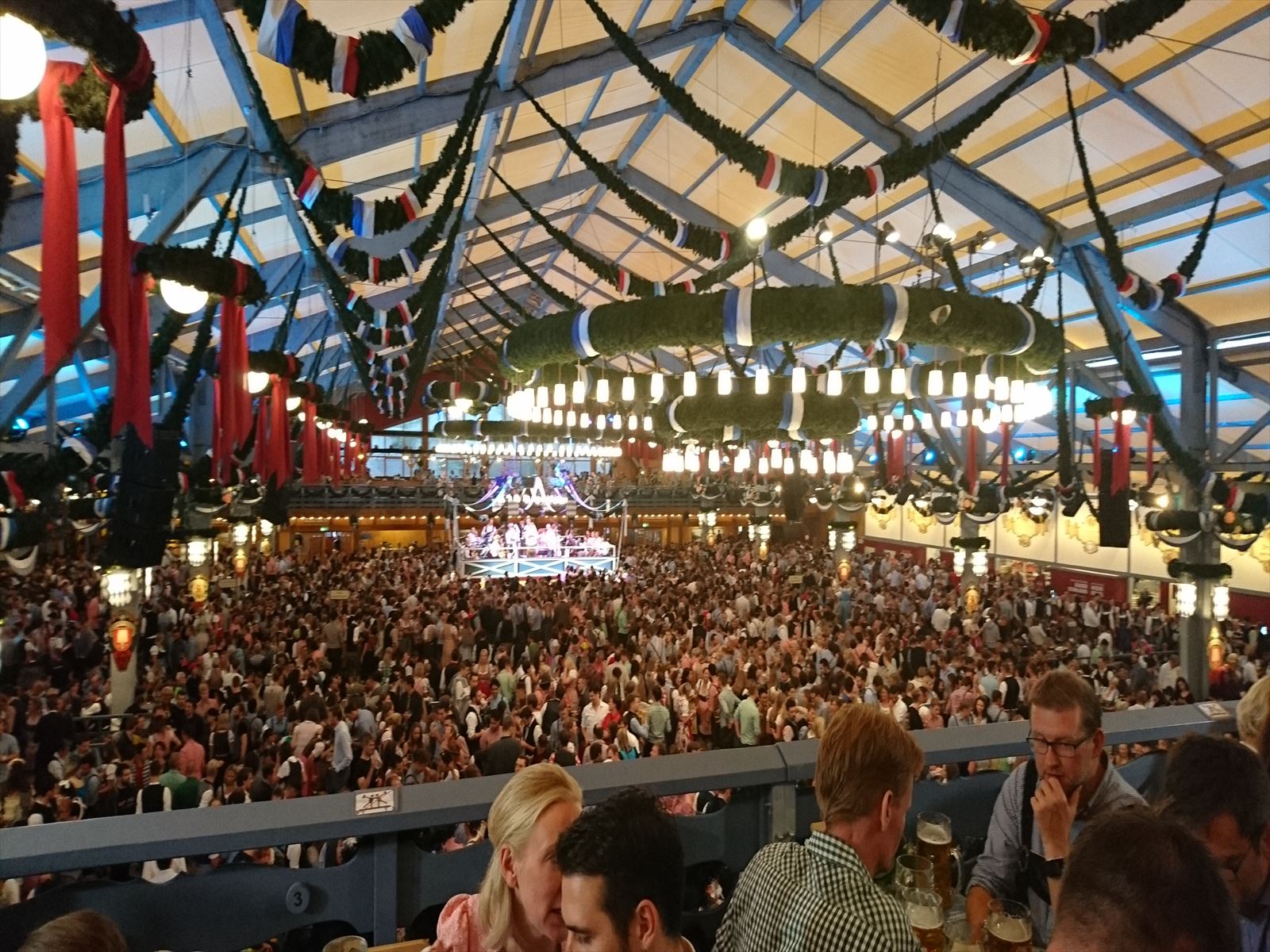
(ミュンヘンのビール祭り、「オクトーバーフェスト」では、収容人数約5,000人規模の巨大な仮設テントが十数カ所開設されるが、そのなかの一つの様子)
(A view of one of the dozen or so giant temporary tents set up at the Munich beer festival ‘Oktoberfest’, with a capacity of around 5,000 people).
1.フォッサマグナ
「地質学者ナウマン伝 フォッサマグナに挑んだお雇い外国人 (朝日選書) 」(矢島 道子 (著) 朝日新聞出版(刊))によると、ミュンヘン大学を卒業して1875年に来日したナウマンは、その後設立された東京帝国大学地質学科の初代教授として、全国の地質調査を進言、立案した。その後、1885年に帰国するまでの10年間、北海道を除く日本全国を広く調査、日本の地質構造について「日本高度階分布地図」として1885年開かれたベルリンの国際学会(万国地質学会議)で発表した。
日本列島は、地質学的には「ユーラシアプレート」と「北米プレート」の境、大地溝帯である「フォッサマグナ」によって、「プレート」が別れ、日本列島の西半分は「ユーラシアプレート」、北海道を含めた東半分は「北米プレート」と、「乗っている土台」が異なる。このフォッサマグナは、下図の肌色で描かれた、日本列島の中央、中部地方から関東地方にかけての地域を縦断する大地溝帯である。西縁は「糸魚川静岡構造線」(糸静線)となっているが、東縁については「新発田小出構造線」、「柏崎千葉構造線」等と諸説あり現在も結論は出ていない。先のコラムにも記したが、フォッサマグナは西縁の「糸静線」と混同されるが、図のとおりフォッサマグナは広大な「地溝帯」である。
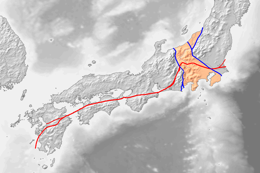
出典:ウィキメディア・コモンズ (Wikimedia Commons)
この「フォッサマグナ」の西縁に「地質構造を別けている岩石の繋がり」が新潟県糸魚川から静岡に至る大陥没地帯(糸静線)を発見、1885年「日本群島の構造と起源について」を発表、フォッサマグナを含め九州、四国、日本列島の地殻構造を詳しく発表した人物こそ、ナウマンである。彼は、その翌年1886年にこの地域を「Fossa Magna」(フォッサマグナ)と命名した。
地震に対するリスクマネジメント・ツールとして「地震保険キャプティブ」を記してきたが、日本全国の地震の発生に様々な点で関係していると考えられている大地溝帯である。
このフォッサマグナの日本海側の起点である糸魚川市に1994年「フォッサマグナミュージアム」がオープンした。フォッサマグナミュージアムの紹介が、次のように同ミュージアムホームページに記されている。
フォッサマグナミュージアムは、地球や日本列島の誕生をわかりやすく展示した、石の博物館です。石は、大地の生い立ちや生命進化を私たちに語ってくれます。石の種類が豊富な糸魚川は、日本列島の生い立ちを知る、日本で最も適した場所の一つです。日本列島を真っ二つにするフォッサマグナや糸魚川-静岡構造線、ヒスイ、太古のサンゴ礁でできた切り立った崖、活火山焼山など、石が語る日本列島の歴史が手にとるようにわかります。
2.中央構造線
上図には、関東から九州に伸びる「赤いライン」が記されている。断層の大規模な動きによって、断層の両側に違う岩石が並び、異なる地質の境界線になっている断層を「構造線」と呼ぶが、この赤いラインは、九州の八代から、徳島、三重、そして諏訪を経て、茨城から太平洋へ抜ける、1000Km以上もある長大な「構造線」であり、「中央構造線」と呼ばれるものであるが、この命名者もナウマンである。英語では、「中央構造線」はMedian Tectonic Line(MTL)と呼ばれ、この大断層を境にして日本海側は「内帯」、太平洋側は「外帯」と呼ばれている。
日本列島の地殻変動は、海側のフィリピン海プレート、太平洋プレートが陸側のユーラシアプレート、北米プレートに沈み込む際、そのエネルギーのベクトルが異なるため、「中央構造線」のなかでも「活断層化している区間」と「活断層化していない区間」が別れ、更に「活断層化している区間」でも、断層の動きと頻度が異なっている。
「大鹿村中央構造線博物館」のホームページには、岡田篤正京都大学名誉教授の論文「中央構造線活断層系の活動区の分割試案 (中央構造線のネオテクトニクス–その意義と問題点)」に依ると思われる次の説明がある。
地表に活断層のずれ動きが生じるのは数百年~数万年に1回で、1回の食い違いは10m以内です。しかし数10万年もずれ動きが繰り返されると、合計の食い違い量は数10m~10数kmに達します。この長期間の食い違いの速度を「活動度」と言い、ふつうは1000年あたりの平均値で表します。1000年平均で1m~10mの食い違い速度(変位速度)の活断層をA級、10cm~1mのものをB級、1cm~10cmのものをC級に区分します。
更に、このうち、「大きな“食い違い”」、つまり活動量が多く、断層型地震が起きた場合、大きな地震になる可能性のある「A級」とされている区間は、次のとおりである。
| 活断層区 | 場所 | 長さ(km) | 活動度 |
| 紀伊半島西 | 五条~紀淡海峡 | 70 | A |
| 淡路島 | 紀淡海峡~鳴門海峡 | 30 | A? |
| 四国北東 | 鳴門~伊予三島 | 106 | A |
| 四国中央 | 伊予三島~小松 | 47 | A |
つまり、1000km以上に及ぶ中央構造線のうち、「活動の度合いが高い区間」が紀伊半島から四国に集中しているのである。「地震保険やキャプティブは、関東圏、また南海トラフ等、地震の発生が強く懸念される地域のモノ」と考えることはできない証左である。
上図のように「世界最大の断層帯」と言われる中央構造線が走る地域では、大地震発生の可能性が大きく、地震保険の補償内容を確かにするためにもキャプティブ設立の検討は必要な企業戦略であると言えるであろう。
3.徳島県内の断層
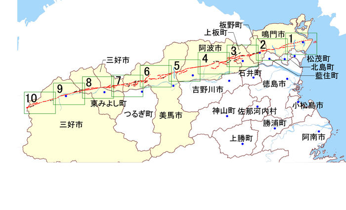
下の地形図は、国土地理院のホームページで公開されている「デジタル標高地形図」の「徳島県」のページから引用したものである。

南の四国山地と図の上部、徳島県(阿波)と香川県(讃岐)の県境、「阿讃山脈(讃岐山脈)」とに囲まれた徳島平野。徳島県内を走る「中央構造線」(三波川帯)は、この「阿讃山脈(讃岐山脈)」の麓を東西に貫く。

(出典:Map-It マップイット | 地図素材サイト(徳島県))
長大な断層、「中央構造線」のすぐ近くに存在する徳島県では、「地震リスクへの備え」に関しては、県が大きなリスク・アラート(リスク警戒)データを発信している。
徳島県のホームページには、「徳島県防災・危機管理情報(安心とくしま)」のページがあり、そこでは、下記「徳島県中央構造線活断層帯(讃岐山脈南縁)活断層図 区割り図」も示されていて、「ご覧になりたい地域の図隔をクリックしていただくと、詳細な活断層図にジャンプします。」と非常に詳細な活断層図のPDFを見ることができるようになっている。
(出典:徳島県ホームページ「徳島県防災・危機管理情報(安心とくしま)」)
4.地震碑が教えるキャプティブの必要性
リスクマネジメント・ツールである「キャプティブの効用を最大限に引き出す損害保険は地震保険」である。その点から筆者が注目したのは、この「徳島県防災・危機管理情報(安心とくしま)」の「防災コラム」のなかで、「南海地震を知る~徳島県の地震・津波碑~」と題して、「地震碑」に関する連載がおこなわれていたことである。
2008年11月13日の第1回、「『南海地震を知る~徳島県の地震・津波碑~』-春日神社『敬渝碑』」から始まって、最終回の2010年2月26日「『南海地震を知る~徳島県の地震・津波碑~』-南海地震津波『最高潮位標識』まで、実に37回に渡って徳島県内にある地震碑を記していった。その連載にあたって次の言葉が記されていた。
「南海地震を知る~徳島県の地震・津波碑~」の連載について
日本最古の津波碑 : 1364年正平南海地震津波の供養碑「康暦碑」徳島県海部郡美波町東由岐
地震・津波被害の歴史を知る資料として、「南海地震を知る~徳島県の地震・津波碑~」をまとめました。本県には、古い貴重な地震・津波碑が多く残されており、これらの碑には、今後の地震・津波防災に生かすべき有用な多くの教訓が刻まれています。
次回から、県内各地に残る過去の南海地震・津波に関する記念碑、供養碑や扁額などを紹介していきます。(添付資料参照:徳島県の地震・津波碑の位置)
産業技術総合研究所(産総研)名誉リサーチャー寒川旭氏が提唱した「地震考古学」を行政が率先しておこなっている見本である。
国土地理院のホームページでは、洪水、土砂災害、地震、津波等の「自然災害伝承碑」として記され、同ホームページには全国367市区町村1224基が公開されているが、これまで多くの地震、津波の被害に遭ってきた徳島地方では多くの碑が残されている。
「徳島県防災・危機管理情報(安心とくしま)」に「徳島県の地震・津波碑の位置」として場所が示されていたものは36基であった。(https://anshin.pref.tokushima.jp/docs/2012090400088/files/2008_0_122715854072.pdf)
「徳島県内の地震津波碑」徳島地方気象台ホームページには地震・津波碑を地震ごとに区分けしたリストが、「徳島県では、過去の南海地震により県南部の沿岸を中心に津波の災害を多く受けてきたことから、地震津波による被害の様子や後世への教訓等を記した石碑が多く建立されています。 これらの碑は、地元の方々以外にはあまり知られていないのが現状のようですので、ここで紹介させていただきます。」との言葉とともに下記のリストが記されていた。
| 正平地震
1361.08.03 |
慶長地震
1605.02.03 |
宝永地震
1707.10.28 |
安政南海地震
1854.12.24 |
昭和南海地震
1946.12.21 |
|
| 宍喰町※ | 最高潮位標識 | ||||
| 海部町※ | 大岩慶長宝永碑 | 鞆浦海嘯記 | |||
| 海南町※ | 観音堂地蔵尊台座 | 天神社石碑 | 天神社前南海大地震記念碑 | ||
| 御崎神社石碑 | 震災後50年南海道地震津波史碑 | ||||
| 千光寺額面 | 津波十訓 | ||||
| 熟田峠地蔵尊 | 最高潮位標識 | ||||
| 観音堂石段の標石 | |||||
| 牟岐町 | 大震潮記念碑 | 南海震災記念碑 | |||
| 観栄寺石碑 | 旭町南海地震記念碑 |
| 牟岐町における南海震災史碑 | |||||
| 最高潮位標識 | |||||
| 由岐町※ | 康暦の碑 | 王子神社石灯籠 | 最高潮位標識 | ||
| 東由岐浦修堤碑 | |||||
| 貞治の碑 | |||||
| 志和岐石柱 | |||||
| 阿南市 | 八幡神社常夜燈 | 住吉神社海嘯潮痕標石 | |||
| 小松島市 | 豊浦神社石碑 | ||||
| 徳島市 | 蛭子神社百度石 | ||||
| 松茂町 | 春日神社敬渝碑 |
※は旧町名のまま表示しています。
2006.03.31の合併により、海部町・海南町・宍喰町は海陽町に、日和佐町・由岐町は美波町になりました。
(「徳島県内の地震津波碑」徳島地方気象台ホームページより)
これだけの「地震碑」があるということは、「地震リスク」が顕在化する可能性が高い地域と言えるであろう。地震保険の備えが必要という「歴史の教え」であろう。しかし、地震国日本では十分な地震保険の補償枠、補償範囲を得ることが困難な状況である。海外の再保険会社の引受キャパシティを確保して地震保険の内容を満足のいくレベルにまで引き上げるツール、「キャプティブ」が必要ということではないだろうか。
今回のまとめ
東日本大震災を経験するまで、地震保険の実態を詳しく検証することはなかった。「当り前の保険」としか考えていなかったからである。しかし、東日本大震災の被害に対する「地震保険制度の頼りなさ」を知れば知るほど、「なんとかしなければ」という思いが強くなった。その思いを叶えてくれた存在が、米国の損害保険会社で勤務していた時に毎日携わっていた「キャプティブ」であった。
しかし、当時携わっていたキャプティブの保険種目は、火災保険がメインであり、西海岸を除いて地震リスクの少ない米国で地震保険を目にすることは少なかったため、「地震保険の引受キャパシティ(引受力)を海外の再保険会社の力によって補完する」という、現在グローバル・リンクが構築したビジネスモデルに接することは無かった。
多くの方々のアドバイスのおかげで、「地震保険の引受キャパシティ(引受力)を海外の再保険会社の力によって補完するためにはキャプティブが最善のツールである」ということに辿り着くことができた。その後、キャプティブの力を遺憾なく発揮できる「地震保険キャプティブ」をグローバル・リンクのメイン事業として開始、以降、地震保険、地震リスクに強い関心を持って臨むようになり、本コラムでも地震リスクをメインに記すようになっている。
さて、上記「中央構造線」の西の端を辿ると、そこは熊本である。2016年4月に発生した「熊本地震」の後、多くの被災者が「熊本には大きな地震は来ないと思っていた」と語っていたことを憶えている。しかし、歴史をひもとけば、熊本は、度々大きな地震、津波に襲われていたことが分かる。
1792年(寛政4年)に熊本を襲った大津波の犠牲者を弔う慰霊碑が熊本市西区河内町にある。1991年に噴火、火砕流が発生、43名の犠牲者を出した雲仙普賢岳は、200年前の1792年、日本の歴史上最大の火山災害を引き起こしている。前年から雲仙岳周辺では地震が頻発していたが、1792年2月10日普賢岳が噴火、溶岩流が流れ出した。その後、3月には雲仙火山の一つ、眉山近くで地震が続いていたが4月1日になり、2度の大地震によって眉山が大規模な山体崩壊を起こし、3億立方メートル以上というとてつもない量の土砂が有明海に流れ込んだ。
そのために発生した高さ20mを超える大津波は、島原のみならず対岸の熊本、天草に押し寄せ、犠牲者は約15,000人に達した。このことから、「島原大変肥後迷惑」という言葉が生まれ今に残っている。
このとき河内一帯の「庄屋」であった鹿子木量平(かのこぎりょうへい)は、後世に伝えるため「津波教訓碑」の建立を藩に願い出て、1795年多くの人々が拠出した資金で完成した。そこには「家から荷物を持ち出そうとした人の多くは溺死した。だから、津波が来たらすべてのことに優先してお年寄りを助け、幼い子供を連れてすぐに逃げなければならない。予め逃げ道を確認しておき、いざというとき迷ってはいけない」と記されている。
「今後30年で発生確率は70~80%」と言われている南海トラフ巨大地震に比べ、国内最大の活断層である「中央構造線断層帯」を震源とする直下型地震は、「今後30年以内0〜0.4%」と発生確率が低いと言われている。しかし、2016年発生した「熊本地震」の発生前の確率は「30年以内の発生確率0〜0.9%)」と低く、上述のとおり「地震は来ない」と多くの人々は思っていたのである。また、その後起きた「鳥取県中部地震」では、「未知の断層」が相次ぎ動き大きな地震となった。こういう点からも、「思い込みにとらわれない地震対策が必要である」と筆者は考えている。
キャプティブの設立は、実質的な地震保険コストを大きく低減させることは多くの実例が証明している。「キャプティブ」という「新しい発想」で、地震リスクへの対応を始めるべきタイミングではないだろうか。
執筆・翻訳者:羽谷 信一郎
English Translation
Risk Management (RM) 72 – Captives prepared for “Risk in place names” 6 (“Median Tectonic Line”, Tokushima)
The captive that Global Link will help establish will act as a reinsurer underwriting reinsurance from Japanese primary insurers, but furthermore, it will be a syndicate of ” Lloyd’s of London” in London and some of the world’s largest reinsurers that will ultimately underwrite most of the risks in the form of “retrocession”. One of these companies, the world’s largest reinsurer, is headquartered in Germany.
I often visited the headquarters for meetings and discussions with them. If the time of year is around autumn, I can occasionally attend the ” world’s biggest festival” held in that city.
Unfortunately, the world’s largest beer festival, Oktoberfest, held from mid-September to early October, was cancelled in 2020 and 2021 due to the “covid-19 disaster”.
Many of the participating Germans, both men and women, were dressed in ” national costumes that are more geographically close to Switzerland than German style”. More than six million people from all over the world attend the ” festival ” to “sing, dance, talk and drink beer” in Munich, a city in the heart of southern Germany.
In the early Meiji era, Heinrich Edmund Naumann was invited from Munich as a so-called “hired foreigner” to become the first professor of the Department of Geology and Mining at the Tokyo Imperial University (now the University of Tokyo).In a science textbook, he is listed as the discoverer of the fossil of an elephant that lived in Japan in ancient times and was named the Naumann elephant after him.
The National Institute of Advanced Industrial Science and Technology (AIST) Geological Survey of Japan (GSJ), to which I have often referred in this column, states on its website that “Dr. Naumann (Germany), the originator of the Naumann elephant name, came to Japan 130 years ago and contributed greatly to laying the foundations of Japanese geology”.
And, “The history of AIST (National Institute of Advanced Industrial Science and Technology) began in 1882 with the establishment of the Geological Survey of Japan (GSJ), a national geological survey organization. The geologist Naumann, who came from Germany, was deeply involved in the establishment of the Geological Survey of Japan”.
Naumann was a geologist from Germany. Naumann not only “left his mark on the name of the elephant”, but also contributed greatly to the development of Japanese geology to this day.
1. The Fossa Magna
According to the book “Geologist Naumann: The Employed Foreigner Who Challenged the Fossa Magna” (Asahi Sensho), written by Michiko Yajima (Asahi Shimbun Shuppan), Naumann came to Japan in 1875 after graduating from the University of Munich, and as the first professor of the Department of Geology at Tokyo Imperial University, he proposed and planned a nationwide geological survey. For ten years, until his return to Germany in 1885, he extensively surveyed the whole of Japan, except Hokkaido, and presented a map of the geological structure of Japan at the International Congress of Geology in Berlin in 1885.
Geologically, the Japanese archipelago is separated into two plates by the Fossa Magna, the Great Rift Valley at the boundary between the Eurasian Plate and the North American Plate, with the western half of the archipelago divided by the Eurasian Plate and the eastern half, including Hokkaido, by the North American Plate. The Fossa Magna is the Great Rift Valley that runs through the central part of the Japanese archipelago, from the Chubu region to the Kanto region, as depicted in the skin-coloured figure below. The western edge of the Fossa Magna is known as the Itoigawa-Shizuoka Tectonic Line (Itoshizu Line), while There are several theories about the eastern margin, such as the “Shibata-koide tectonic line” and the “Kashiwazaki-Chiba tectonic line”, and no conclusion has been reached to date. As mentioned in the previous column, the Fossa Magna is often confused with the Itoshizu Line on the western margin, but as shown in the figure, the Fossa Magna is a vast “rift valley”.
Source: Wikimedia Commons
On the western margin of the Fossa Magna, Naumann discovered a large depression from Itoigawa in Niigata Prefecture to Shizuoka Prefecture (the Itoshizu Line), which is connected to the rocks that separate the geological structure of the Fossa Magna, and published “On the Structure and Origin of the Japanese Archipelago” in 1885, detailing the crustal structure of Kyushu, Shikoku and the Japanese archipelago, including the Fossa Magna. The following year, in 1886, he published his first book, “The Structure and Origin of the Japanese Islands”. The following year, in 1886, he named this area the “Fossa Magna”. I have noted ”earthquake insurance captives” as a risk management tool against earthquakes, and the rift valley is thought to be related in many ways to the occurrence of earthquakes across Japan.
The Fossa Magna Museum was opened in 1994 in Itoigawa, the starting point of the Fossa Magna on the Sea of Japan side. The following is a description of the Fossa Magna Museum on the museum’s website
The Fossa Magna Museum is a stone museum that displays the birth of the earth and the Japanese archipelago in an easy-to-understand way. The stones tell us about the origin of the earth and the evolution of life. Itoigawa, with its rich variety of stones, is one of the best places in Japan to learn about the origins of the Japanese archipelago. The Fossa Magna, which cuts the Japanese archipelago in half, the Itoigawa-Shizuoka Tectonic Line, jade, steep cliffs made of ancient coral reefs, and the active volcano Yakeyama, all tell us the history of the Japanese archipelago as told by stones.
2. Median Tectonic Line
The “red line” stretching from the Kanto to Kyushu is marked in the diagram above. It is called the “Tectonic Line” because of the massive movement of the faults, where different rocks line up on both sides of the faults and form a boundary between different geological features. In English, it is called the “Median Tectonic Line”, and its namesake is also Naumann. In English, it is called the Median Tectonic Line (MTL), and the Sea of Japan side is called the Inner Zone and the Pacific side the Outer Zone, bordered by this great fault.
The crustal movement of the Japanese Islands is caused by different energy vectors when the Philippine Sea Plate and the Pacific Plate on the sea side subduct into the Eurasian Plate and the North American Plate on the land side. Therefore, even within the Median Tectonic Line, there are sections that are active faults and sections that are not active faults, and even within the sections that are active faults, the movement and frequency of the faults are different.
On the website of the Oshikamura Median Tectonic Line Museum, there is an explanation that seems to be based on a paper written by Atsumasa Okada, Professor Emeritus of Kyoto University, entitled “A Proposal for Dividing the Active Zone of the Median Tectonic Line Active Fault System (Neotectonics of the Median Tectonic Line: Its Significance and Problems)”.
The displacement of active faults on the earth’s surface occurs only once every several hundred to several tens of thousands of years, and each discrepancy is less than 10 meters. However, if the displacement is repeated for several hundred thousand years, the total discrepancy reaches several tens of metres to several tens of kilometres. Active faults with a displacement velocity of 1 m to 10 m per 1000 years are classified as Class A, those with a displacement velocity of 10 cm to 1 m are classified as Class B, and those with a displacement velocity of 1 cm to 10 cm are classified as Class C.
Furthermore, of these, the sections that were considered to be “Class A” with “large “discrepancies”, i.e. high activity and the possibility of a large earthquake if a fault-type earthquake occurred, are as follows.
| Active fault zone | Location | Length (km) | Activity level |
| West of Kii Peninsula | Gojo – Kitan Strait | 70 | A |
| Awaji Island | Kitan Strait – Naruto Strait | 30 | A? |
| Northeast Shikoku | Naruto – Iyomishima | 106 | A |
| Central Shikoku | Iyomishima – Komatsu | 47 | A |
In other words, of the more than 1000 km of the Median Tectonic Line, the “highly active section” is concentrated from the Kii Peninsula to Shikoku. This proves that earthquake insurance and captives cannot be regarded as something for the Kanto region, the Nankai Trough and other areas where there is strong concern about the occurrence of earthquakes.
As shown in the diagram above, in areas where the Median Tectonic Line, which is said to be the ” world’s largest fault zone”, runs, the possibility of a major earthquake is great, and it is a necessary corporate strategy to consider the establishment of a captive to ensure earthquake insurance coverage.
3. Faults in Tokushima Prefecture
The topographic map below is taken from the page of “Tokushima Prefecture” of “Digital Elevation Topographic Map” published in the homepage of Geographical Survey Institute (GSI).
Tokushima plain is surrounded by the Shikoku mountain range in the south and the Asan mountain range (Sanuki mountain range) at the border between Tokushima (Awa) and Kagawa (Sanuki) prefectures. The “Median Tectonic Line” (Sanbagawa Belt), which runs through Tokushima Prefecture, runs east to west through the foot of the Asan (Sanuki) Mountain Range.
(Source: Map-It Map-It – Map Material Site (Tokushima Prefecture))
In Tokushima Prefecture, which is located very close to the Median Tectonic Line, a long fault line, the prefecture has issued a major risk alert data on its “earthquake risk preparedness”. On the website of Tokushima Prefecture, there is a page called “Tokushima Prefecture Disaster Prevention and Risk Management Information (Anshin Tokushima)”, which also shows the “Tokushima Prefecture Median Tectonic Line Active Fault Zone (Southern Rim of Sanuki Mountain Range) Active Fault Map”. “Click on the area of interest to jump to a detailed active fault map”. and a PDF of a very detailed active fault map is available.
(Source: the website of Tokushima Prefecture, “Tokushima Prefecture Disaster Prevention and Risk Management Information (Anshin Tokushima)”
4. What Earthquake Monuments teach us about the need for captives
The risk and non-life insurance that maximises the effectiveness of captives as a risk management tool is earthquake insurance, and in this regard, the author noticed a series of articles on earthquake monuments in the ” Disaster Prevention Column” of the Tokushima Prefecture Disaster Prevention and Risk Management Information (Anzen Tokushima), entitled “Understanding the Nankai Earthquake – Tokushima Prefecture Earthquake and Tsunami Monument”.
The first article, “Understanding the Nankai Earthquake – Tokushima Prefecture’s Earthquake and Tsunami Monuments”, was published on 13 November 2008, and the last article, “Understanding the Nankai Earthquake – Tokushima Prefecture’s Earthquake and Tsunami Monuments – Nankai Earthquake Tsunami ‘Highest Tide Sign'”, was published on 26 February 2010. In this series of 37 articles, we have written about the earthquake monuments in Tokushima Prefecture. The following words were included in the series.
About the series of “Understanding the Nankai Earthquake – Earthquake and Tsunami Monuments in Tokushima Prefecture
Japan’s oldest tsunami monument: “Koreki-hi,” a memorial to the Shohei Nankai Earthquake and Tsunami of 1364, Higashi-Yuki, Minami-cho, Kaifu-gun, Tokushima Prefecture
As a resource for understanding the history of earthquake and tsunami damage, we have compiled a series of articles entitled “Understanding the Nankai Earthquake: Earthquake and Tsunami Monuments in Tokushima Prefecture”. There are many old and valuable monuments to earthquakes and tsunamis in Tokushima Prefecture, and these monuments contain many useful lessons that should be applied to future earthquake and tsunami disaster prevention.
In the next article, we will introduce some of the monuments, memorials and plaques related to the past Nankai earthquakes and tsunamis that remain in various parts of the prefecture. (See attached: Location of Earthquake and Tsunami Monuments in Tokushima Prefecture)
This is an example of the government taking the lead in “earthquake archaeology” as advocated by Dr. Akira Sangawa, a researcher emeritus at the National Institute of Advanced Industrial Science and Technology (AIST).
The Geospatial Information Authority of Japan (GSI) lists 1,224 monuments to natural disasters such as floods, landslides, earthquakes and tsunamis on its website.
The Tokushima Prefecture Disaster Prevention and Risk Management Information (Anshin-Tokushima) lists 36 monuments as “Tokushima Prefecture Earthquake and Tsunami Monument Locations”. (https://anshin.pref.tokushima.jp/docs/2012090400088/files/2008_0_122715854072.pdf)
The Tokushima District Meteorological Observatory website has a list of earthquake and tsunami monuments classified by earthquake: “Tokushima Prefecture has suffered many tsunami disasters in the past, mainly along the southern coast of the prefecture due to the Nankai earthquake, and many stone monuments have been erected to describe the earthquake and tsunami damage and lessons for future generations. These monuments have been erected by local people in other parts of the prefecture. These monuments are not well known outside of the local community, so we are pleased to introduce them here.” The following list was written with the words.
The presence of so many “Earthquake Monuments ” would indicate that the area is likely to be a “seismic risk” area. This is probably a ” lesson of history” that earthquake insurance is necessary to be prepared. However, it is difficult to obtain sufficient earthquake insurance cover and coverage in earthquake-prone Japan. This may mean that a tool, a ” captive “, is needed to ensure the underwriting capacity of overseas reinsurers and bring the content of earthquake insurance to a satisfactory level.
Summary of this issue
Until the Great East Japan Earthquake, I had never examined the reality of earthquake insurance in detail. This is because I had only considered it to be a ” natural insurance policy”. However, the more I learnt about the unreliability of the earthquake insurance system for damage caused by the Great East Japan Earthquake, the stronger my desire to do something about it became. This desire was fulfilled by a captive, which I was involved in every day when I was working for a non-life insurance company in the USA.
However, the captives I was involved in at the time mainly covered fire insurance, and earthquake insurance was rarely seen in the US, where there is little earthquake risk, except on the West Coast. Therefore, I had never come into contact with the business model that Global Link has now established, whereby the underwriting capacity of earthquake insurance is supplemented by the strength of overseas reinsurers.
Thanks to the advice of many people, we came to the conclusion that captives are the best tool to supplement earthquake underwriting capacity with the help of overseas reinsurers. Since then, Global Link has launched the ” earthquake insurance captive”, which can fully utilise the power of captives, as its main business, and has since taken a strong interest in earthquake insurance and earthquake risk, which is also the main focus of this column.
Now, if you follow the western end of the Median Tectonic Line, you will come to Kumamoto, where many victims of the April 2016 Kumamoto earthquake said they thought there would never be a major earthquake in Kumamoto. However, if you look back in history, you will find that Kumamoto has frequently been hit by major earthquakes and tsunamis.
Unzen Fugendake, which erupted in 1991 and caused a pyroclastic flow that killed 43 people, caused the biggest volcanic disaster in Japanese history 200 years ago in 1792. The previous year there had been frequent earthquakes in the area around Mount Unzen, but on 10 February 1792 Mount Fugen erupted and lava flows poured out. Then, in March, there was a series of earthquakes near Bizan, one of the Unzen volcanoes, but on April 1, two major earthquakes caused Bizan to collapse, and a tremendous amount of sediment, over 300 million cubic metres, flowed into the Ariake Sea.
The resulting tsunami, over 20 metres high, swept not only Shimabara but also Kumamoto and Amakusa on the other side of the sea, killing some 15,000 people. This led to the phrase “Shimabara is a great inconvenience and give trouble to Higo”, which has remained to this day.
At this time, Ryohei Kanokogi, the headman of the Kawachi area, asked the clan to erect a monument to the lessons of the tsunami. The monument was completed in 1795 with funds contributed by many people, and reads: “Many people who tried to take their belongings out of their houses drowned. Therefore, when the tsunami comes, you must, above all things, save the elderly, take your young children and run away immediately. Make sure you know how to get away and don’t get lost in an emergency”.
Compared to the Nankai Trough earthquake, which has a 70-80% probability of occurring in the next 30 years, a direct earthquake with its epicentre in the Median Tectonic Line Fault Zone, Japan’s largest active fault, has a lower probability of occurring, at 0-0.4% within the next 30 years. However, before the Kumamoto earthquake in 2016, the probability was as low as 0 to 0.9% (probability of occurrence within 30 years), and as mentioned above, many people thought that there would be no earthquake. Later, in the Chubu Tottori earthquake, an unknown fault line moved one after another, causing a major earthquake. From this point of view, the author believes that it is necessary to take measures against earthquakes without being bound by assumptions.
Many examples have shown that the establishment of a captive can substantially reduce the cost of earthquake insurance. It is time to start dealing with earthquake risk with a “new idea”: captives.
Author/translator: Shinichiro Hatani